All Activity
- Past hour
-

Central PA Winter 25/26 Discussion and Obs
MAG5035 replied to MAG5035's topic in Upstate New York/Pennsylvania
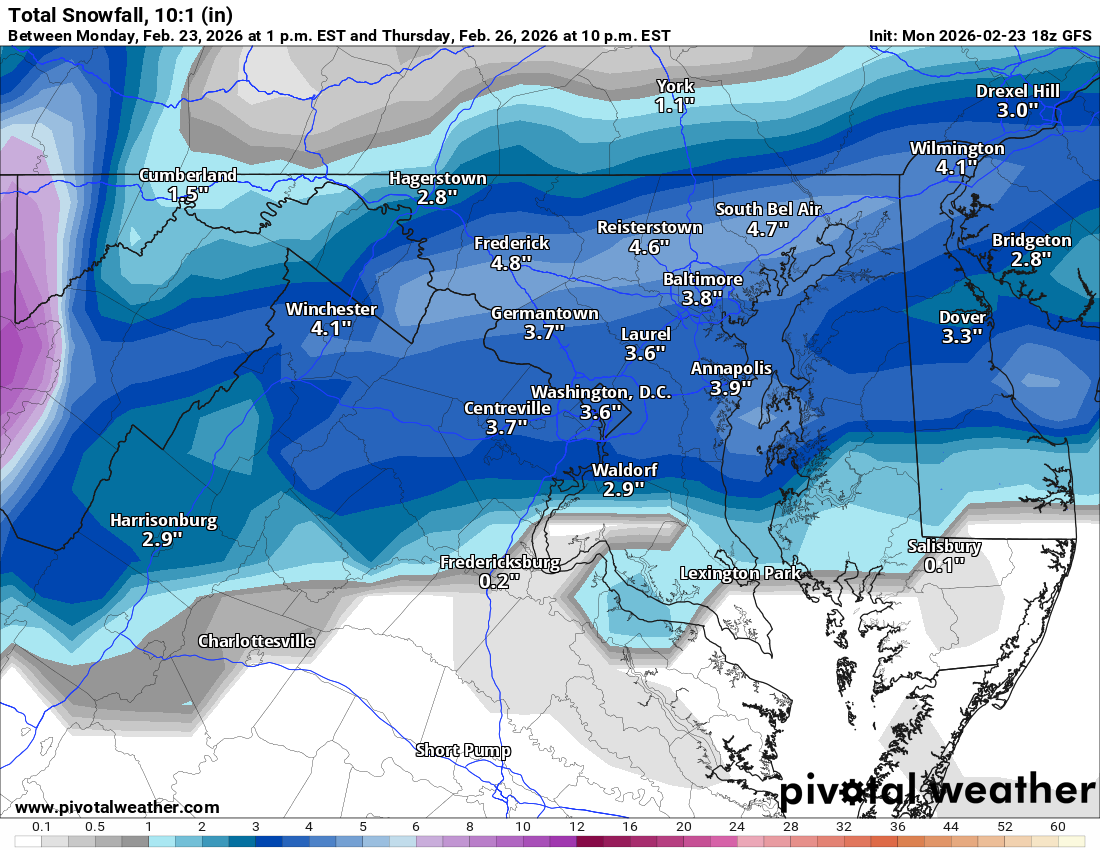
2.9” was what ended up calling the snow total here, about 1.3” from approx midnight to 8am Sunday morning and then another 1.6” from mid Sunday evening thru mid morning today. Some upslope stuff trying to set up so maybe can sneak a little bit more. This brings my season total to a fairly meh 28.7”, generally on par with the last 4 winters if winter ended today. Plenty of time obviously but it’s starting to get late. Clipper tomorrow night will likely favor NW PA, Laurels and perhaps down I-80 over to the Poconos. Track of the low staying in the lakes doesn’t bode well for much making it into the Sus Valley (downsloping). Then we’ll see what we have to work with for Thursday’s wave. Today’s suite has GFS/Euro ops skirting most precip south, Canadian half decent, and NAM/RRFS more mix/rain confining snows to northern PA. GFS/Euro ensembles look a little more amped on average vs their ops. I think most of us should see precip from this wave, my main concern is p-type issues. -

"Don’t do it" 2026 Blizzard obs, updates and pictures.
CTWeatherFreak replied to Ginx snewx's topic in New England
Anybody have a total for West Hartford? -
I have legit paid zero attention to this with work going on and the storm yesterday. This is a pretty good look with some decent cold in place and the usual mess of vorticity moving eastward. I might get pulled back in
-
Is there such a thing?
-
There's a bunch of 18-19s east of me but they missed the best of the def zone dump that sat over me for hours. This one has bigger drifts than the one last month but, because it's so much warmer, compacted and condensed quickly. Did I break 20? Probably but there's no place on my property that wasn't badly wind affected so I'll never really know. I think my back has aged out of fully appreciating 2 blockbusters in a month
-

"Don’t do it" 2026 Blizzard obs, updates and pictures.
sophware replied to Ginx snewx's topic in New England
In my area, about 10 minutes south of Providence, it's almost all powder. I have major health problems and was able to shovel a path to my car. Started out super wet last night but somehow ended up light. It's not just "not heavy," it's light. Can't make a snowball. Sorry to hear the people have cement-like snow. -
So I take most of the videos on my phone. I’ll then upload them to my computer before converting them on ezgif.com making sure the framerate and length are good, I then optimize the gif so that it doesn’t tank everyone’s bit rate on the site, resave to my computer, then upload to imgur.com where I can hot link the gif so it just pops up in the post.
-

"Don’t do it" 2026 Blizzard obs, updates and pictures.
TauntonBlizzard2013 replied to Ginx snewx's topic in New England
Still ripping here. Prob 1-2” an hour -
"Don’t do it" 2026 Blizzard obs, updates and pictures.
TauntonBlizzard2013 replied to Ginx snewx's topic in New England
That was Jan 22. This beats that. I didn’t really complain about this. Mid week it looked like a miss. -
Exactly 1 PM for that report so the extra .15 should get CP to about 21 inches. But it's CP so probably gets it to 19.9 .
-
Frederick Jack.
-
Agree this feels way lower impact than the system 4 weeks ago ironically.
-

February 2026 OBS & Discussion
donsutherland1 replied to Stormlover74's topic in New York City Metro
A monster blizzard has departed the region after leaving its mark in the record books. Central Park saw its 9th biggest snowstorm on record. Newark experienced its second largest snowstorm. Bridgeport's 20.0" snowfall tied February 17-18, 2003 for the second biggest on record. Both Islip and Providence set new records for their biggest snowstorm on record. 1 SE Warwick, RI picked up 36.2" of snow. New York City's 10 Biggest Snowstorms: 1 27.5", January 22-24, 2016 2 26.9", February 11-12, 2006 3 26.4", December 26-27, 1947 4 21.0", March 12-14, 1888 5 20.9", February 25-26, 2010 6 20.2", January 7-8, 1996 7 20.0", December 26-27, 2010 8 19.8", February 16-17, 2003 9 19.7", February 22-23, 2026 10 19.0", January 26-27, 2011 As a result, Winter 2025-2026 has become just the 10th winter with two 10" or above snowstorms in New York City. The others were 1895-1996, 1925-1926, 1960-1961, 1977-1978, 1995-1996, 2003-2004, 2009-2010 (3 such storms), 2010-2011, and 2013-2014. Even more impressive, Winter 2025-2026 will is on track to join Winters 1960-1961 and 1977-1978 as the only winters with two or more 10" snowstorms, a seasonal mean temperature of 32° or below and seasonal snowfall of 40.0" or above. Following the blizzard, tomorrow will be fair and unseasonably cold. Wednesday will be somewhat milder with some rain showers. A period of rain or wet snow is possible late Thursday and Thursday night. The ENSO Region 1+2 anomaly was +1.2°C and the Region 3.4 anomaly was -0.1°C for the week centered around February 11. For the past six weeks, the ENSO Region 1+2 anomaly has averaged +0.37°C and the ENSO Region 3.4 anomaly has averaged -0.32°C. Neutral ENSO conditions have now developed. Neutral ENSO conditions will continue through at least mid-spring. The SOI was +5.96 today. The preliminary Arctic Oscillation (AO) was +0.459 today. Based on sensitivity analysis applied to the latest guidance, there is an implied near 100% probability that New York City will have a cooler than normal February (1991-2020 normal). February will likely finish with a mean temperature near 31.5° (4.4° below normal). Supplemental Information: The projected mean would be 3.8° below the 1981-2010 normal monthly value. Overall, Winter 2025-2026 is on track for a seasonal mean temperature of 31.9°. If a 32.0° or below seasonal mean temperature occurs, that would be the lowest winter mean temperature since Winter 2014-2015 when the mean temperature was 31.7°. Winter 2025-2026 would only become the fourth winter of the 21st century with a mean temperature of 32.0° or below. -

Feb 22nd/23rd "There's no way..." Obs Thread
Herb@MAWS replied to Maestrobjwa's topic in Mid Atlantic
0.98” rain + melted snow — Columbia. -

"Don’t do it" 2026 Blizzard obs, updates and pictures.
ScituateMA replied to Ginx snewx's topic in New England
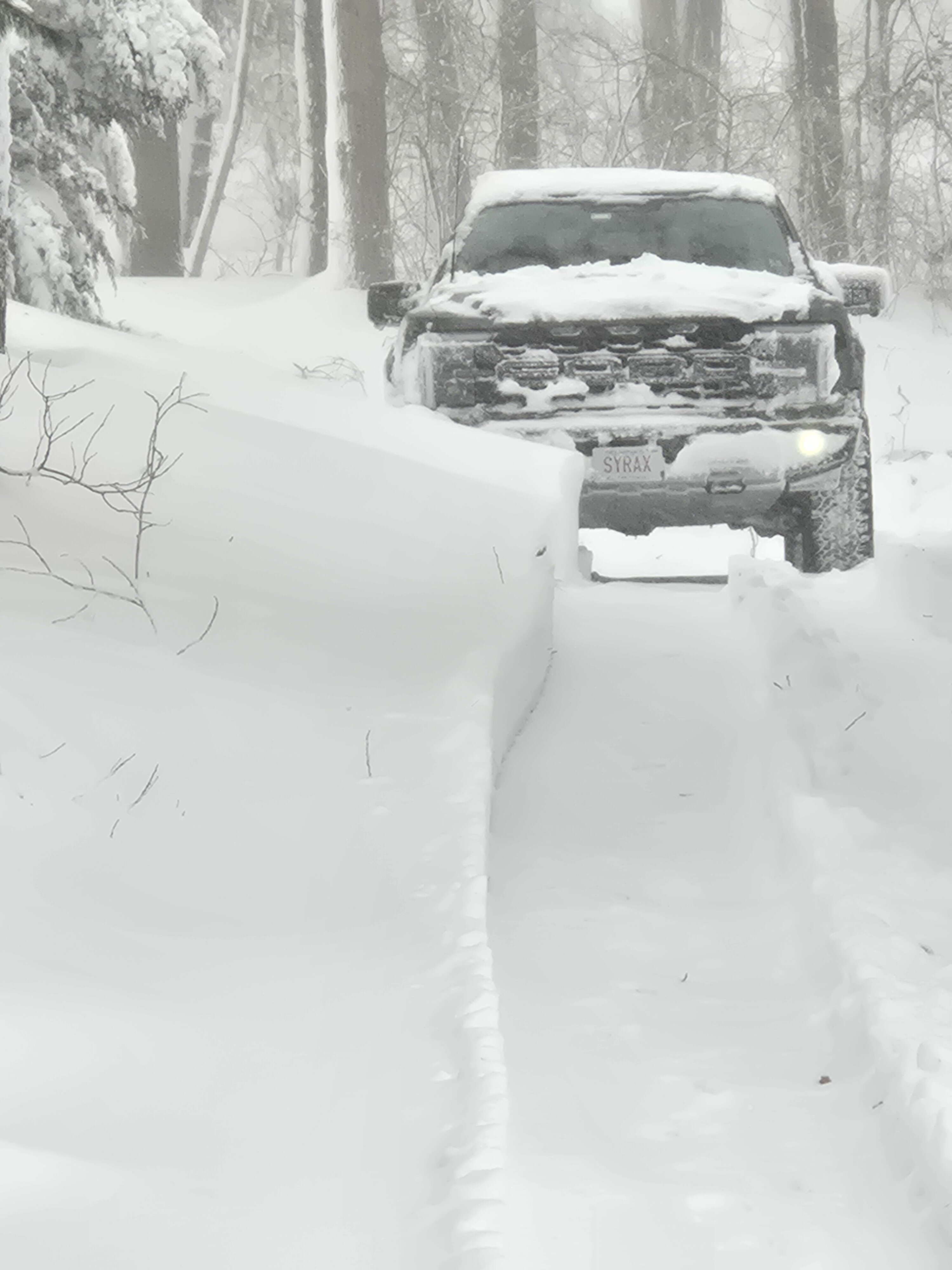
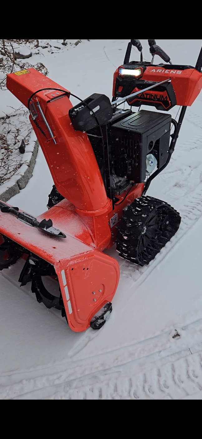
My raptor is on 35's The ariens ate 3 to 4 foot drifts the whole way down my moms 500 foot driveway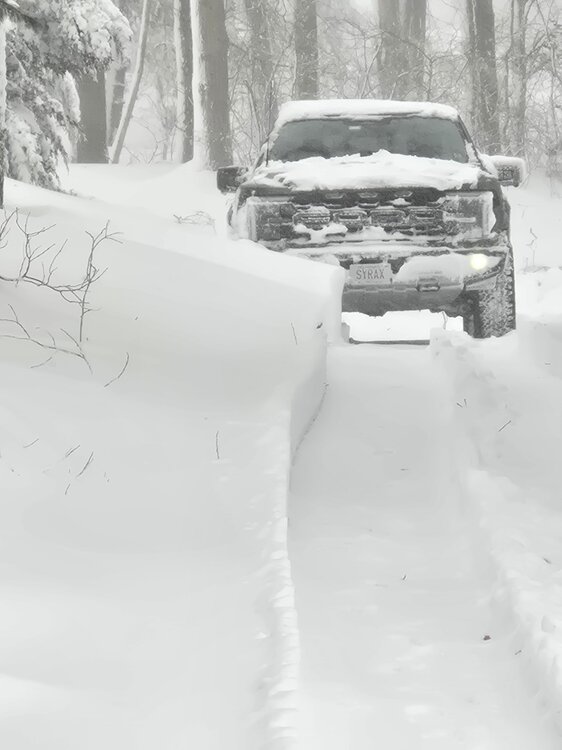

-
"Don’t do it" 2026 Blizzard obs, updates and pictures.
rnaude241 replied to Ginx snewx's topic in New England
These last 6 hours have been absolutely incredible. It still won't stop snowing here. -
I'll go with 11" here Thomaston, CT
-
Deep into April?
-
If you don’t mind me asking, which type of software are you using to embed those clips? I used to work in still photography years ago but never got a chance to get into film. Has always been kind of a dream to be able to create a documentary. You have a really good eye for the visual arts.
-

"Don’t do it" 2026 Blizzard obs, updates and pictures.
H2Otown_WX replied to Ginx snewx's topic in New England
Congrats man, how much OTG? -
Long long way to go folks.
-
lol

-

E PA/NJ/DE Winter 2025-26 Obs/Discussion
RedSky replied to LVblizzard's topic in Philadelphia Region
Brandon Copic live stream is wild Too much snow in Rhode Island -
Or Sussex County?
-