All Activity
- Past hour
-

January 2026 regional war/obs/disco thread
dendrite replied to Baroclinic Zone's topic in New England
What a time to be alive -

January 2026 regional war/obs/disco thread
ORH_wxman replied to Baroclinic Zone's topic in New England
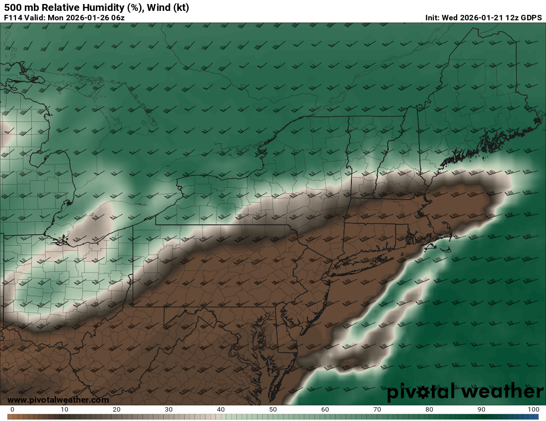
That’s basically what it is already on the solutions that don’t really energize the coastal (such as the icon at 12z)….but at least if that happens, this is a fantastic airmass and confluence setup to have a SWFE. Maximize the moisture. -
I had like 3-4” of sleet in VD storm 07 and ya it sucked. You don’t wanna be out in it getting pelted and it was and night and little breezy and just sounded like pebbles blasting my window.
-

Possible Record Breaking Cold + Snow Sunday 1/25 - Tuesday 1/27
forkyfork replied to TriPol's topic in New York City Metro
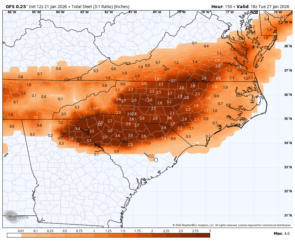
the precip will shut off before we can get much sleet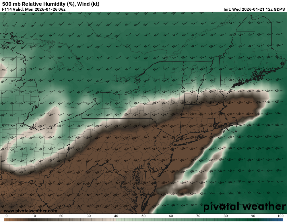
-
12z GEFS looks like it cut way back on precip.
-
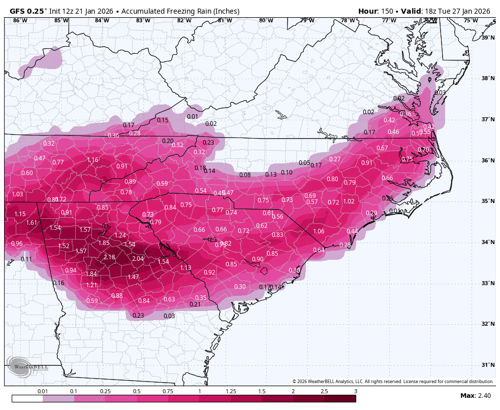
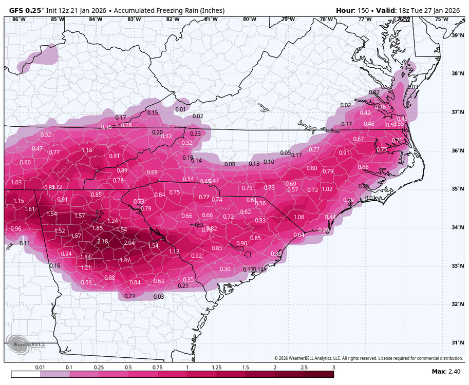
Cant imagine much worse set up, ice on top of a snow pack
-
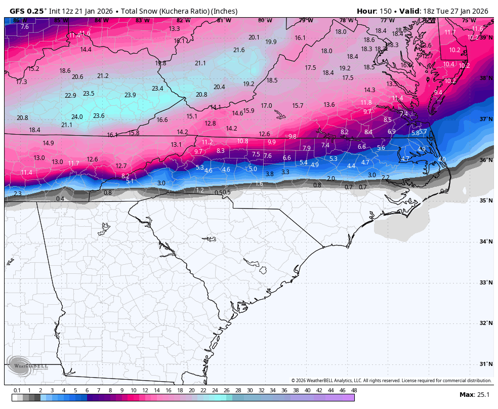
I’ve pretty much given up on getting major snow in the Triad, need the Canadian to go even further the north to miss the ice. The kids are gonna love the sledding. It’s going to be epic. But man, the power people, etc. Looks like it could be rough. For a lot of our state
-
Sweet bleeding deities - A SINGLE RUN of one model is NOT a trend. On top of those invoking the waking horror of the 0z runs --those were around a foot encapsulated in sleet to keep us all in a skating rink for weeks. In between the 6z runs pulled back from that and then GFS that JUST RAN was not that either. So, then the CMC comes along, always our most amped model (do we not remember such things year over year - a few years back it gave us 60 inches at one point six days out which was beyond hilarious for something that didn't even turn into a storm) - and it is, dear lord, shocking super amped, and we still even on that one get 6-12" before glaciating it in ice and it is a trend? I am a simple and dumb person, really, when it comes to atmospheric physics and fluid dynamics, but IF the high is what it is supposed to be, there is only so far north this can drive even with help from whatever ridging the CMC is showing back west to allow this - so... tl/dr putonbigpersonpants, certain people.
-

January 2026 regional war/obs/disco thread
TheSnowman replied to Baroclinic Zone's topic in New England
No one, ABSOLUTELY No one is touching that yard unless it’s me or my parents. NO one. I’m a Nazi with how it gets shoveled, AS is my dad. And it’s massively broken up old asphalt at this point, snow blowers would shoot rocks through the windows. They’d rather stay stuck at home vs. that. -
Flatter AIGFS fwiw
-

2025-2026 Fall/Winter Mountain Thread
buckeyefan1 replied to Buckethead's topic in Southeastern States

-
My Dad's cancer returned.
-

Possible Record Breaking Cold + Snow Sunday 1/25 - Tuesday 1/27
SnoSki14 replied to TriPol's topic in New York City Metro
This is an expansive and unusually cold Arctic airmass this time. I think it'll be very difficult for low to plow through it. -

January 2026 regional war/obs/disco thread
8611Blizz replied to Baroclinic Zone's topic in New England
Somebody will need to take Anthony's weapon off him. -
The question is, did he use performance enhancing drugs?.
-
Alright, ill try again this time. Ukie less amped than that crazy zonked 0z run.
-
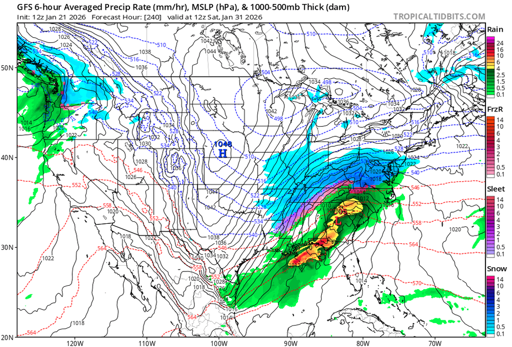
GFS for the win @ 234 in Long range
-
This is my fear of where the problems will truly occur. Wind picks up as this storm pumps on exit...After we have coated trees and power lines from the zr precip. Sunday noon and after could just be one breakage and compiling catastrophe after another.
-
January 21 1936: Warroad drops to a bone-chilling 55 below zero. 1922: The barometer at Collegeville hits 31.11 inches, a record high pressure reading for the state. For Wednesday, January 21, 2026 1863 - A severe coastal storm dropped heavy rain on the Fredericksburg area of Virginia. It disrupted a Union Army offensive in an ill famed "mud march." (David Ludlum) 1982 - The second of two major snowstorms to hit southern Minnesota came to an end. Minneapolis received 20 inches of snow in 24 hours to break the previous record of 17 inches in 24 hours established just a few days earlier. A record 38 inches of snow covered the ground following the two storms, with drifts ten feet high. (David Ludlum) 1985 - Three days of snow squalls at Buffalo NY finally came to an end. The squalls, induced by relatively warm water in Lake Erie, produced 34 inches of snow at the International Airport, with up to 47 inches reported in the suburbs of Buffalo. The New York "blizzard of '85" left many counties disaster areas. (19th-21st) (Weather Channel) (Storm Data) President Reagan was sworn in for a second term in the coldest Inauguration Ceremony of record. Cold and wind resulted in wind chill readings as much as 30 degrees below zero. (Sandra and TI Richard Sanders - 1987) 1987 - Low pressure over Minnesota produced high winds in the Northern Plains Region. Winds gusted to 66 mph at Rapid City SD, and reached 70 mph at Belle Fourche SD. (National Weather Summary) (Storm Data) 1988 - High pressure over northern Nevada and low pressure off the coast of southern California combined to produce high winds in the southwestern U.S. Wind gusts in the San Francisco area reached 70 mph at Fremont. (National Weather Summary) (Storm Data) 1989 - Cold and snow prevailed in the northeastern U.S. Up to 13 inches of snow was reported between Woodford and Searsburg in Vermont. Montpelier VT reported a wind chill reading of 42 degrees below zero. (National Weather Summary) (Storm Data) 1990 - Unseasonably warm weather prevailed across the state of Florida. Eight cities reported record high temperatures for the date, including West Palm Beach with a reading of 86 degrees. Rain in southern New England changed to freezing rain, then to sleet, and then to heavy snow during the late morning. Most of Massachusetts was blanketed with 6 to 10 inches of snow. (National Weather Summary) (Storm Data)
-
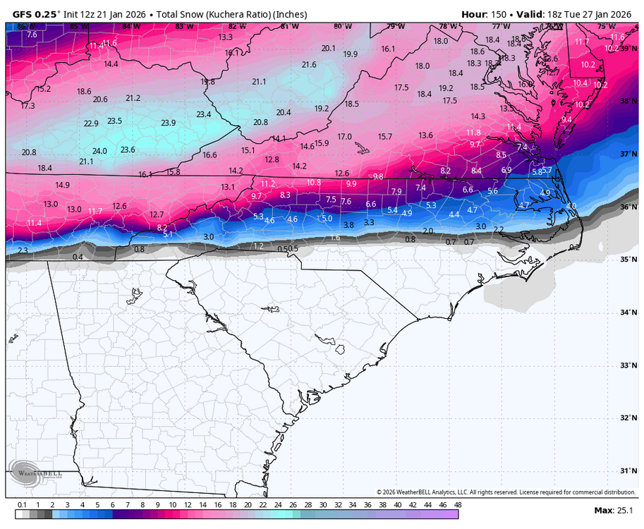
ratios will be slightly higher NW of 95, and that zone that gets a little less snow also gets more sleet after the flip, in the end it evens out...everyone ends up with like 8-10" OTG probably...area's NW do it with more sleet, along 95 with a quick heavy snow thump before a flip and more dryslot.
-
-
Getting some practice on these setups. A game for the redux
-
I am just trying to understand how it can cut like that? That is a stout banana high. I would think it would try to jump way earlier than that. But again. I dont know anything apparently.
-
In a meeting at work. Boss opens with “be prepared for next week it’s going to be a bad storm, i follow Jay’s Wintery Mix on Facebook and he is never wrong”. I almost fell out of my chair lol
-

January 2026 regional war/obs/disco thread
CoastalWx replied to Baroclinic Zone's topic in New England
Watch this become a SWFE lol