All Activity
- Past hour
-
-
DCA with an intra-hour 97°. I think we do stand a chance to make 100° today.
-
Best climo
-
99 at my station now but hit 100 a few minutes ago
-
^wow. They're a lock for 100. Probably Philly and Lancaster too!
-
Holly shit, 98 degrees F. Heat index 114 before noon Extreme Heat Warning until July 4, 08:00 PM EDT Current conditions at Wilmington Airport (KILG) Lat: 39.67°NLon: 75.61°WElev: 72ft. Fair 98°F 37°C Humidity 51% Wind Speed Vrbl 6 mph Barometer 30.04 in (1017.0 mb) Dewpoint 77°F (25°C) Visibility 10.00 mi Heat Index 114°F (46°C) Last update 2 Jul 10:51 am EDT
-
Yeah really the worst of this will be up in the DC region. Not that it won't suck here as well but the dp's up there are horrendous.
-
yeah it definitely stays cooler than it used to - I'd imagine midtown is pushing 100F at the moment. Heat waves like this in NY are horrible - the subway stations easily get to like 120-130F.
-
Extreme heat events such as this one, with tropical moisture, have a decent potential of ending with a bang.
-
98 here in Brooklyn
-
Would be nice to do pollution control without letting in more sun and heat.
-

Central PA Summer 2026 Discussion/Obs Thread
canderson replied to Voyager's topic in Upstate New York/Pennsylvania
Same here. Not as humid as yesterday so in the shade isn’t quite as oppressive yet. -

Central PA Summer 2026 Discussion/Obs Thread
Itstrainingtime replied to Voyager's topic in Upstate New York/Pennsylvania
My fully-shaded weather station is now reading 95.4 at 11:20am. -
NYC is the Central Park site, yes? The NYC subforum has been screeching for years about poor vegetation management on that location. For NCY to be 94° in essentially an over shaded, sheltered location at 11am bodes we for an upper 90s kind of day.
-
Yes apparent temp is a combo map. It's heat index when it's hot, wind chill when it's cold. All credit goes to @wxmeddler
-
regional round up: BOS at 91 (low of 78) EWR is at 96 already lol (low of 82) NYC at 94F (low of 82) - should be the first 100 there since the 2010s LGA at 94F (low of 84) - the Queens/Brooklyn heat island is absolutely fierce. PHL at 94F (low of 80) This is a proper Acela corridor heat wave.
-

2026 Mid-Atlantic Severe Storm General Discussion
dailylurker replied to Kmlwx's topic in Mid Atlantic
Justin Berk is honking on a flood threat for Sunday and Monday.- 885 replies
-
- 1
-

-
- severe
- thunderstorms
- (and 7 more)
-
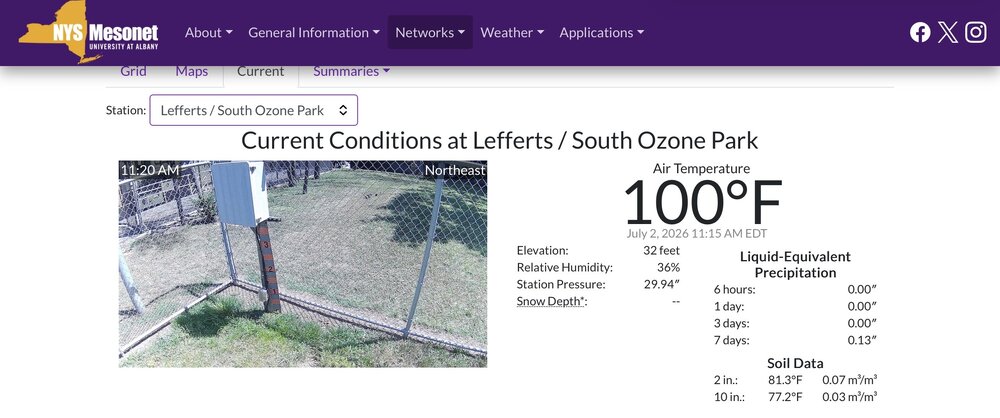
Lefferts/South Ozone Park now at 100.
-
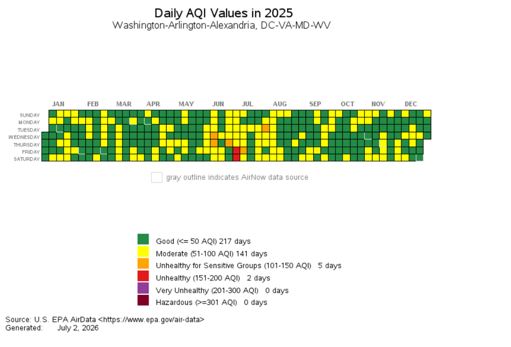
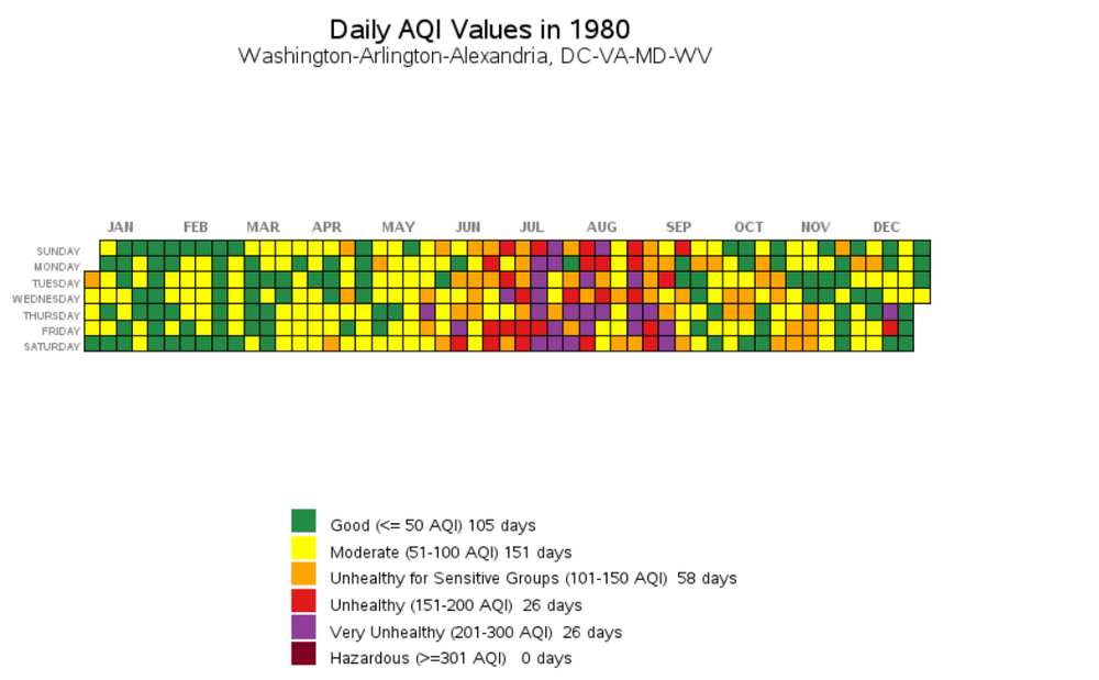
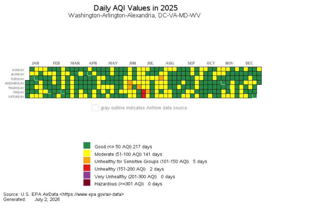
Hear hear - I work in urban planning so think about this stuff a lot. 2025 versus 1995 for the AQI... great visualization tool on this page https://www.epa.gov/outdoor-air-quality-data/airdata-tile-plot (which I think I got off this site years ago). sorry for the digression.. edit - adding 1980 for fun - thanks clean air act
-
DCA at 95 now.
-

E PA/NJ/DE Summer 2026 Obs/Discussion
Joshb32689 replied to PhiEaglesfan712's topic in Philadelphia Region
91/78 outside of Coatesville as of 1115am. Thinking we don’t break 100 today That 106 heat index is something else though -
Yeah, it's really strange, because you would expect downsloping to produce lower DPs in the western Piedmont not higher
.thumb.png.b822878da2da249afac8b29cfd045e25.png)
-
Already 97 in Crofton and 96 here east of Crofton in the woods. Wild DP and heat in the South River watershed.
-

2026-2027 Super El Nino
40/70 Benchmark replied to Stormchaserchuck1's topic in Weather Forecasting and Discussion
Yes, it will be better, but the question is how much better...as Chris says. -
Just north of there working. Can confirm. Its cooking and im already soaked lol


.png.96974298f8ec1a279f53f6b2cdbe468e.png)
