All Activity
- Past hour
-
What's going on with the Atlantic? Large scale BN anomalies all over. Do we think it's real cooling or just a function of the cooler air masses we've had cooling the very surface level but nothing else?
-
I'll take the 3km please
-
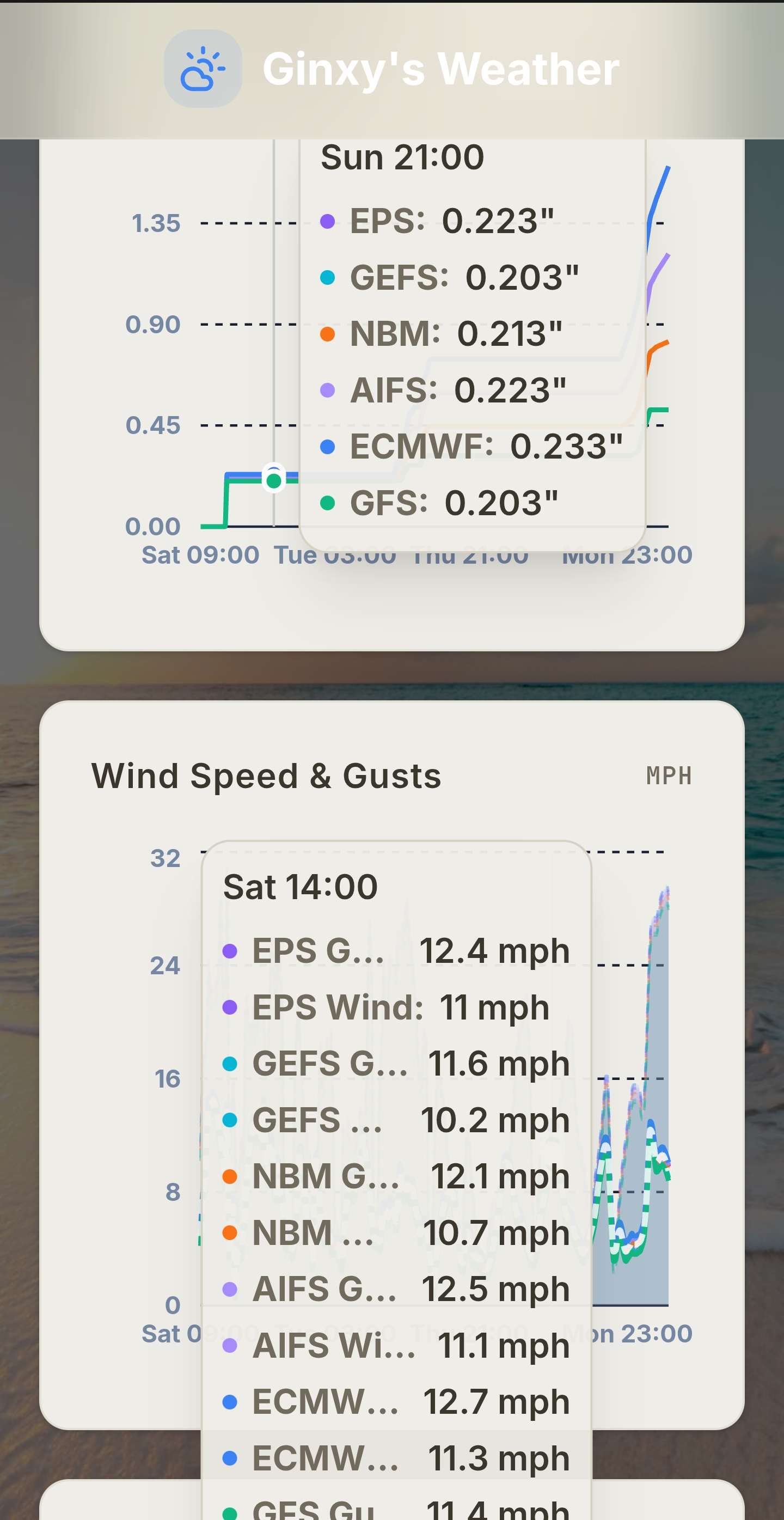
.25 seems likely for me today. Just had some sprinkles

-

2026 Mid-Atlantic Severe Storm General Discussion
Eskimo Joe replied to Kmlwx's topic in Mid Atlantic
Yup. Looks like down to I-70 to I-95. -
This stuff will thin out will be well in the 80s, but I mentioned this yesterday
-

Junorch obs and discussion 2026
TauntonBlizzard2013 replied to Damage In Tolland's topic in New England
Yeah, too bad none of us in this forum live in NJ. Looks like a meh day here, prob around 80 -
 Agree. Just got to keep watering the plants. See how drought tolerant the clover is. Grass is going quick.
 -
Its water.
-
Looks like the SLGT risk and MRGL risk lines were nudged southward a tad on 1300z SPC OTLK
-

Central PA Summer 2026 Discussion/Obs Thread
mahantango#1 replied to Voyager's topic in Upstate New York/Pennsylvania
Sounds like there is quite a bit of concern with these thunderstorms that will develop later today as they could become severe. -
 It definitely will. Just a question of when. My wag is September-October.
 -

Junorch obs and discussion 2026
Damage In Tolland replied to Damage In Tolland's topic in New England
I think you know the answer . That doesn’t wash Fert in -
I am 80% sure that you’ll have at least a quarter inch. and if it doesn’t rain, why can’t you just use your sprinklers?
-
Nothing special at all
-
-
Junorch obs and discussion 2026
TauntonBlizzard2013 replied to Damage In Tolland's topic in New England
We cloud. So much for a hot sunny Saturday -
Gotta say...the RRFS has been quite consistent in its evolution. It's really liked up around the Albany area
-

2026-2027 Super El Nino
snowman19 replied to Stormchaserchuck1's topic in Weather Forecasting and Discussion
I don’t think the new EURO ONI/RONI projections are far-fetched at all given the massive SOI crash, the continued big WWBs, the new DWKW, the record warm subsurface, +IOD development, ++PMM, OLR anomalies, MJO/ERW constructive interference and the extremely rapid surface warming that has started. This event is showing signs of going into a “runaway” Bjerknes feedback loop. I would not be surprised if we are into a super El Niño by August -

Central PA Summer 2026 Discussion/Obs Thread
canderson replied to Voyager's topic in Upstate New York/Pennsylvania
Will be driving back from Ephrata around 6 pm. Should be interesting. -
A bit of a change in plans. Going to go to Bennington, VT and start from there. There are some decent viewing spots. Secondary area (which would be only 30 minutes away) is Wigwam Western Summit in North Adams which looks like it has a tremendous view to the west. Really tough part about today is the mesoscale aspect of how this unfolds. The greatest potential seems to be well down into PA but given its a very late PM threat its probably not worth the 4+ hour drive.
-
i know right, seasonal snowfall here in one storm. 44.7" in New Haven, 50 in Middletown. And considering the date im willing to bet most of these are probably snow depth or 24hr totals combined.
-
Summers just the best.. look at all that beautiful pollen..
-
Already 78 here at 9am. Going to be a special day... Another hot afternoon ahead, H850 temps progged +16C to +18C, allow surface temperatures to climb well into the 80s for most and lower 90s in the urban NYC metro and NE NJ corridor
-
I got some meger rain last evening 3mm instead of 8, at one point WUN had me at 27mm/1" which I waved off. Nil overnight but any rain has been removed for today just overcast til 2pm then partly sunny for the rest of the weekend! For a while it showed a washout weekend like 2 weeks ago now just a blip. A dream pattern is shortly setting up with heat and 2 days of storm potential mid-week. Isolated storms so far with 8mm of rain mid-Tues.
-
Yes