All Activity
- Past hour
-
Most major models have the storm next weekend cutting under us from the Gulf and up the coast. That's a very strong signal this far out. GFS has it as well
-

Pittsburgh/Western PA WINTER ‘25/‘26
Burghblizz replied to Burghblizz's topic in Upstate New York/Pennsylvania
I doubt we get there even in the win scenario. I think the official 10th biggest is around 15” or 16”. While the official total tends to be on the higher side when it comes to seasonal totals, it’s usually on the lower side with major storms. Storms like Jan ‘94 and Jan ‘96 are nowhere to be found, even though parts of AGC/Wash/Westmoreland got 20”+. I don’t think that’s what we are looking at here, but man it would be nice. -
Gem keeps valley below freezing out to 72 the at 76 takes the low up the mountains and temps at 38
-

January 24-26: Miracle or Mirage JV/Banter Thread!
clskinsfan replied to SnowenOutThere's topic in Mid Atlantic
Just ran to the grocery store. It was complete madness. All I really needed was beer and hot dog buns ffs. Picked up 2 six packs of New Belgium trippel. Gonna be tuned up on Sunday watching the the snow dump and Championship Games. I imagine my shoveling skills are going to deteriorate about as fast as the roads out here. -
The December 26th storm did this. The NAM nailed the sleet in central Jersey when GFS was saying snow. The mix line always tends to punch north faster and further than what the GFS says.
-

“Cory’s in LA! Let’s MECS!” Jan. 24-26 Disco
RUNNAWAYICEBERG replied to TheSnowman's topic in New England
Crusher… -
DCA is 48F at 11am, 50F in Tenleytown.
-
Surrounded by 70+% open water, albeit running cooler than normal. Incredible. I wonder if the industrial chicken houses there even have insulation.
-
 cmc looks weaker stronger confluence from the high by Montreal
 -

January 24-26: Miracle or Mirage JV/Banter Thread!
mattie g replied to SnowenOutThere's topic in Mid Atlantic
I ride the line for a few hours even in my neck of the woods just west of the DC Beltway. Soundings and temp maps make it look OK, but I won't confident of that unless other guidance agrees. -

2025-2026 Fall/Winter Mountain Thread
Maggie Valley Steve replied to Buckethead's topic in Southeastern States
This sure looking like 48 to possibly a near 60 hour event for precipitation for the Mountains. Ugly ugly ugly. There is nothing good about this Major Winter Storm approaching catastrophic if these trends continue. -

Possible Record Breaking Cold + Snow Sunday 1/25 - Tuesday 1/27
SACRUS replied to TriPol's topic in New York City Metro
1/22 12z GFS AI AIGFS: Total QPF storm Total Snow / Sleet (10:1) -

Possible Record Breaking Cold + Snow Sunday 1/25 - Tuesday 1/27
eduggs replied to TriPol's topic in New York City Metro
I'll be following the ECM-AI closely too. Anecdotally it's done great this year. That and the NAM for how far north mixing gets. The AIs plus CMC are pretty amped - it looks like that's where we're headed. The GFS is heavily discounted in my mind. -

Possible Record Breaking Cold + Snow Sunday 1/25 - Tuesday 1/27
NJwx85 replied to TriPol's topic in New York City Metro
12Z GFS is about as perfect as it gets for our area. -

Possible Record Breaking Cold + Snow Sunday 1/25 - Tuesday 1/27
OrangeCTWX replied to TriPol's topic in New York City Metro
AI brings the primary into WV and ultimately brings the secondary next to the outer cape. GFS doesn’t really get close to doing either of those. -

January 24-26: Miracle or Mirage JV/Banter Thread!
DanTheMan replied to SnowenOutThere's topic in Mid Atlantic
The sleet/ice component is going to make this pretty memorable I think regardless of how much snow falls first -
GFS just absolutely demolishes people with 15-18in
-
Prob a pretty decent call right now based on most guidance. You can almost broadbrush 10-16 across SNE. Maybe go slightly more conservative on the islands. There also might be a stripe of slightly higher amounts if there’s good OES enhancement and CF enhancement in a few spots, but I wouldn’t want to forecast explicitly over 16” for any one spot.
-

Possible Record Breaking Cold + Snow Sunday 1/25 - Tuesday 1/27
Wxbear25 replied to TriPol's topic in New York City Metro
GFS is almost ideal for pretty much everyone in the sub-forum… messier phase leads to less pronounced mid-level features and quicker transition to the coast. of course it’s been a day late and a dollar short this whole time, so it can’t be trusted without other support but it’s at least nice to see oh, and it’s nasty little tendency to underdo mid-level warmth. Pretty big issue -

Possible Record Breaking Cold + Snow Sunday 1/25 - Tuesday 1/27
Stormlover74 replied to TriPol's topic in New York City Metro
It sucks at picking out warm layers so if the mesos show it i discount the gfs -

Possible Record Breaking Cold + Snow Sunday 1/25 - Tuesday 1/27
winterwx21 replied to TriPol's topic in New York City Metro
I'm at 18.5" here in Piscataway. Already a very good winter, so I'll be very happy even if this gets cut down to a 6 to 10 inch storm due to mixing. Would've loved all snow with a potential of a foot and a half like the models were showing a couple days ago, but I'm happy that we're looking at our best front end dump type of storm in quite awhile. This storm alone should get us close normal snowfall for an entire winter, and as you said we still have what is usually our best snow month (February) ahead of us. -

Central PA Winter 25/26 Discussion and Obs
GrandmasterB replied to MAG5035's topic in Upstate New York/Pennsylvania
GFS is super long duration due to the coastal influence. It’s a little bit alone in that aspect, but let’s hope it’s onto something! -

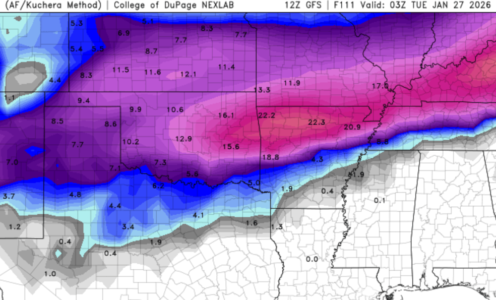
Central PA Winter 25/26 Discussion and Obs
AccuChris replied to MAG5035's topic in Upstate New York/Pennsylvania
12z GFS kuchera zoomed in on Harrisburg area . -

Possible Record Breaking Cold + Snow Sunday 1/25 - Tuesday 1/27
LawdogGRNJ replied to TriPol's topic in New York City Metro
Lots of discussion about amount total changes...Has the timing changed much? -

MO/KS/AR/OK 2025-2026 Winter Discussion
The Ole Bucket replied to stormdragonwx's topic in Central/Western States