All Activity
- Past hour
-

Rise of the Machines: January 18-19 Winter Storm Obs Thread
Damage In Tolland replied to WxWatcher007's topic in New England

-

January 18th Back Door NW Trend Snow OBS Thread
KamuSnow replied to Mikeymac5306's topic in Philadelphia Region
Maybe, but show me model output from the end of last week that had 5 -10" area-wide (west of the river anyway)? We may have underperformed in South Jersey, but I don't think we did over here. Regardless, woo hoo!!! -

Rise of the Machines: January 18-19 Winter Storm Obs Thread
powderfreak replied to WxWatcher007's topic in New England
Nice! -
Carver and others, The WxBell Euro AIFS ens snow maps have a flaw so major that the 12Z run (just for one example) had one member (#38) 300 miles offshore in the Gulf getting a foot of snow within a 6 hour period while the temp was 65F+! You read that right, a 2”/hour snowstorm with temps in the 60s. These maps are so flawed than even Joe Bastardi, himself, noticed the same problem a few weeks ago! If even Joe noted this, well….use these at your own risk. The regular EPS snow maps are otoh legit:
-
Classic Flash Freeze. Road & Air temps just above freezing. Get either light rain or snow, enough to get everything wet. Then clear skies post frontal turns everything to ice.
-
20.4/9.8 at 8:45 pm with NW 11 gusting 18 mph breeze. Chilly. WC feels like 8 to 5 degrees with those combos.
-
 HRRR is another 3-5 here. We’ll see
 -

Rise of the Machines: January 18-19 Winter Storm Obs Thread
Torch Tiger replied to WxWatcher007's topic in New England
Around 1.75" so far today -
Just a note in Eastern Hoco. Roads were a disaster this evening. My youngest should have had ice skates on the car instead of wheels. Accidents everywhere. Shows that this town with only .4 of snow is a cluster fuck. Untreated roads though so….
-
Rise of the Machines: January 18-19 Winter Storm Obs Thread
Damage In Tolland replied to WxWatcher007's topic in New England
That’s combined -

Rise of the Machines: January 18-19 Winter Storm Obs Thread
moneypitmike replied to WxWatcher007's topic in New England
Congrats! -

Winter 2025-26 Short Range Discussion
Torchageddon replied to SchaumburgStormer's topic in Lakes/Ohio Valley
Issued: 4:39 PM Jan. 18, 2026 – Environment and Climate Change Canada Snow squalls beginning overnight. Blizzard Monday afternoon and evening. What: Blizzard conditions with near zero visibility. Westerly winds gusting 70 to 90 km/h. Wind chills between minus 20 and minus 25. Snowfall accumulations of 20 to 40 cm. Locally higher amounts possible. When: Snow squalls beginning overnight. Blizzard conditions Monday afternoon through Monday evening. Heaviest snowfall amounts expected Monday night into Tuesday. Additional information: Lake effect snow squalls will begin overnight. Strong westerly winds will develop Monday afternoon, producing blizzard conditions in blowing snow. Winds and blowing snow will diminish Monday evening, however, snow squalls will continue into Tuesday. ### Travel will be dangerous and likely impossible due to near-zero visibility. Road closures are possible. Please continue to monitor alerts and forecasts issued by Environment Canada. To report severe weather, send an email to [email protected] or post reports on X using #ONStorm. For more information about the alerting program, please visit: https://www.canada.ca/en/services/envi This will mainly be for the northern Bruce peninsula i.e. Blizz. This is a terribly constructed 'Orange' warning for a blizzard; it doesn't specify that the heaviest snow is in the far north spots. In contrast, southern Bruce county is set to receive 5cm aft and eve (TWN). It doesn't label it as a 'lake effect blizzard' which this is (I'm doubtful I'll meet the criteria). It contradicts itself with the timing stating it will go on in the evening in one section then stating blowing snow will diminish Mon eve! -

Pittsburgh/Western PA WINTER ‘25/‘26
colonel717 replied to Burghblizz's topic in Upstate New York/Pennsylvania
There are arguments for both sides. If the storm is a little quicker and can outrun the High should get it north. Per the latest EURO the storm develops around hour 120. What is crazy is how the storm looks at hour 144, the temp here is 5 degree. Can you recall getting snow at that temp. I cannot. Coldest I can remember is snowing in teens. -
Rise of the Machines: January 18-19 Winter Storm Obs Thread
moneypitmike replied to WxWatcher007's topic in New England
I don't really know I do like that they now have these "event total" ones so you don't start adding amounts to what's already come down. -

Rise of the Machines: January 18-19 Winter Storm Obs Thread
SouthCoastMA replied to WxWatcher007's topic in New England
3.75" so far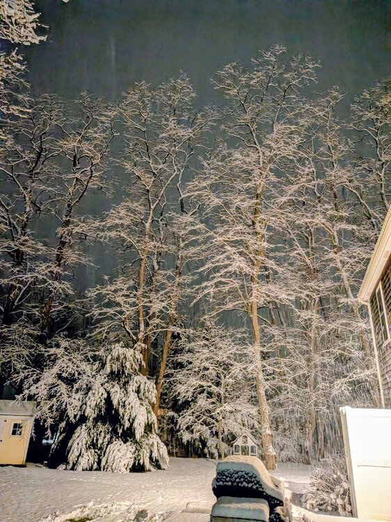
-
Down to flurries. Going to finish with 1.75" on bare ground. Still about 1" on untreated surfaces. Heavy sloppy snow. Everything will turn to a sheet of ice overnight.
-

January 18th Back Door NW Trend Snow OBS Thread
Kevin Reilly replied to Mikeymac5306's topic in Philadelphia Region
Just finished shoveling 2.0” so 3.3” on the day. There are diamonds shining in the snow. 26f partly cloudy stars appear that was dramatic. 5.1” on the weekend not bad when you thought you were getting 1-1.5” at best all weekend. We have a snow pack single digits almost a certainty next few days. Total snow for the year: 14.5” -
1/18: 0.5” 4.3” season total
-

Central PA Winter 25/26 Discussion and Obs
TimB replied to MAG5035's topic in Upstate New York/Pennsylvania
It’s on Reddit. I watch it from time to time. -

Rise of the Machines: January 18-19 Winter Storm Obs Thread
CCHurricane replied to WxWatcher007's topic in New England
These became mostly automated at some point in the recent past, correct? Feel like they’ve been far too volatile / unreliable vs. the previous iteration. -
Is February 94 showing up in the analogs yet? Ill take that but 100 miles south. https://www.meteo.psu.edu/ewall/NARR/1994/us0209.php#picture
-
While not an overperformer, I still have a solid 2”+ and it looks like a winter wonderland outside.
-

Storm potential January 17th-18th
sussexcountyobs replied to WeatherGeek2025's topic in New York City Metro
When he gets home. Tell him to shovel. He'll be ok. -

January 18th Back Door NW Trend Snow OBS Thread
Hurricane Agnes replied to Mikeymac5306's topic in Philadelphia Region
When the Euro and the NAM agree over multiple runs, then... -

Rise of the Machines: January 18-19 Winter Storm Obs Thread
Cobalt replied to WxWatcher007's topic in New England
@qg_omegahas the easiest job on planet earth in predicting warm East coast winters and has been wrong 2 years running. After predicting record warmth last winter and being off by 5+ degrees I’d have hopped over to the basket weaving forum if I was him. At least there’s less of a chance of being wrong over there.


.thumb.jpeg.f5c6ba9d911ec96b3b124f8606aee58e.jpeg)


