All Activity
- Past hour
-
Generally cooler weather will prevail through the weekend. A storm will bring a soaking rain to the New York City region Sunday night and Monday. A general 0.50"-1.50" rainfall with locally higher amounts is likely. The rain could end as flurries or a period of wet snow in some of the distant northern and western suburbs. Following storm, a shot of much cooler air could arrive on Tuesday. Lows in New York City could fall to the middle and upper 20s with highs in the upper 30s and lower 40s on Wednesday and Thursday. However, with the AO likely to remain generally positive through around March 20th, the cool period likely won't be as prolonged as had been the case during this past winter's cold regimes. Uncertainty about the closing 7-10 days of March has increased. The major weather story next week will be the super March heatwave that will develop in much of the western U.S. March monthly records are likely to be smashed in numerous cities, including Albuquerque, Flagstaff, Fresno, Las Vegas, Palm Springs, Phoenix, Reno, Salt Lake City, and Yuma. The ENSO Region 1+2 anomaly was +0.9°C and the Region 3.4 anomaly was -0.1°C for the week centered around March 4. For the past six weeks, the ENSO Region 1+2 anomaly has averaged +0.80°C and the ENSO Region 3.4 anomaly has averaged -0.23°C. Neutral ENSO conditions have now developed. Neutral ENSO conditions will continue through at least mid-spring. The SOI was +10.43 today. The preliminary Arctic Oscillation (AO) was +2.305 today. Based on sensitivity analysis applied to the latest guidance, there is an implied 70% probability that New York City will have a warmer than normal March (1991-2020 normal). March will likely finish with a mean temperature near 44.6° (1.8° above normal). Supplemental Information: The projected mean would be 2.1° above the 1981-2010 normal monthly value.
-
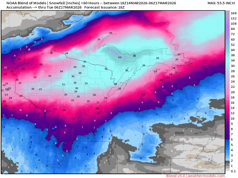
NBM 5.0:
-
From snow anus to snow anal.
-
Action
-

E PA/NJ/DE Spring 2026 Obs/Discussion
Ralph Wiggum replied to PhiEaglesfan712's topic in Philadelphia Region
High of 37 coming tuesday, high of 39 wednesday. It just snowed 2 days ago. Am I missing something? Sustained cold isnt really a thing this tme of year but a day of 2 BN here and there works. -
51 today. Blustery but still spent a lot of time outside with dog and kids.
-
North crew anal front this time?
-
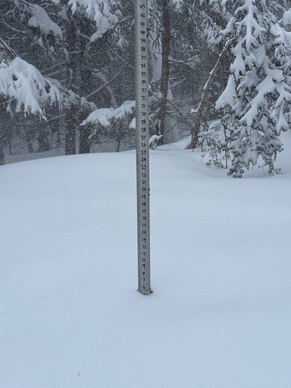
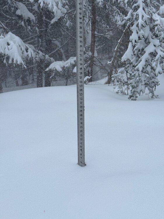
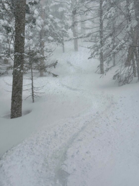
Another 6” between 8:30am and 4pm. Storm total 9” so far. Heavy snow. Depth at 3,000ft back up from 52” to 61”.

-
After Dec.8th been living on the margins all winter
-
Ladies and gentlemen, prepare yourself. We got one more left in us.
-
Let’s hoist em up regionwide
-

2026 Mid-Atlantic Severe Storm General Discussion
WxWatcher007 replied to Kmlwx's topic in Mid Atlantic
This one…has legs? -
I never really root for another March 2012 because it did result in an agricultural disaster as we got some cold shots the following April. From a pure meteorology standpoint, however, it was awesome.
-
-NAO trends for 3/23-29 have lead to BN signal NE: 4 days ago: Now:
-

E PA/NJ/DE Spring 2026 Obs/Discussion
JTA66 replied to PhiEaglesfan712's topic in Philadelphia Region
First ice cream truck sighting of the season. -
HWW issued up here with gusts up to 60mph possible Monday.
-
Mood flaking. Big dog or bust. Going to be an awesome storm for MSP
-
Agree. When you talk march 2012 you aren't talking mild, when you talk feb 2015 you aren't talking cold. Youre talking historic on a local level. And theres no sign of that here. For the SW its even worse because they are getting their march 2012 now,.but they already average way warmer.
-

E PA/NJ/DE Spring 2026 Obs/Discussion
PhiEaglesfan712 replied to PhiEaglesfan712's topic in Philadelphia Region
The problem is that it won't be cold enough to snow. Average highs are in the mid 50s and average lows are in the mid 30s. We are probably aren't going to stray too far from these averages the next few weeks. -

Central PA Spring 2026 Discussion/Obs Thread
Voyager replied to Voyager's topic in Upstate New York/Pennsylvania
Unbelievable. And here we (I anyway) freeze. I really hate that we've been "locked in" to this pattern all winter. -
There was a study done on the March 2012 heatwave and I believe they concluded that it was a 1 in 4,000 year event at the time. I still think it ruined some people’s perceptions of how a normal spring is supposed to look, even to this day. Then on the flip side you have Feb 2015 which was one of the coldest months in modern history. Not quite as anomalous as March 2012, but still a very impressive month.
-
E PA/NJ/DE Spring 2026 Obs/Discussion
Ralph Wiggum replied to PhiEaglesfan712's topic in Philadelphia Region
Hey, some of us are too busy over analyzing the fantasy snowstorm on the long range gfs. Right where we want it: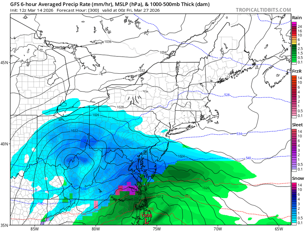
-
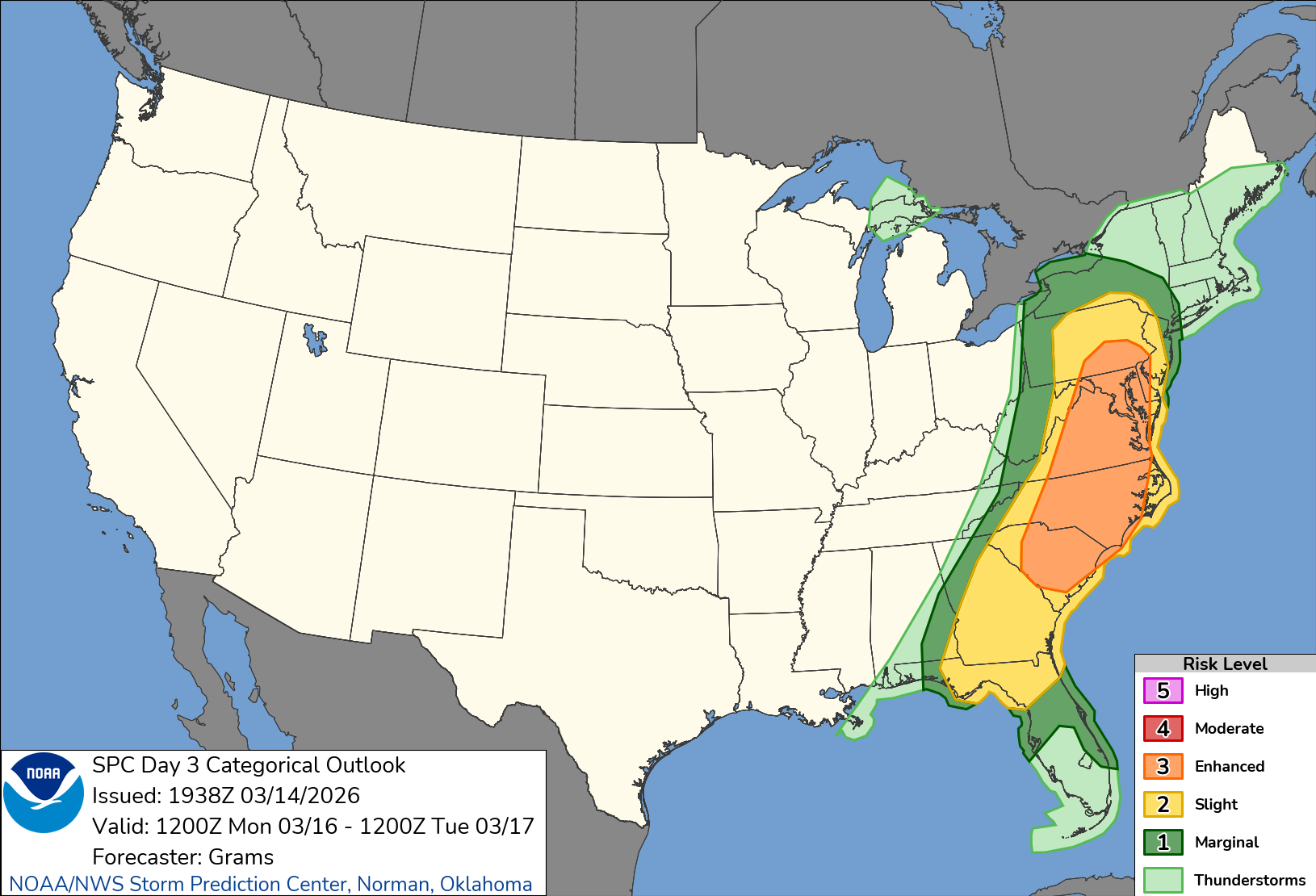
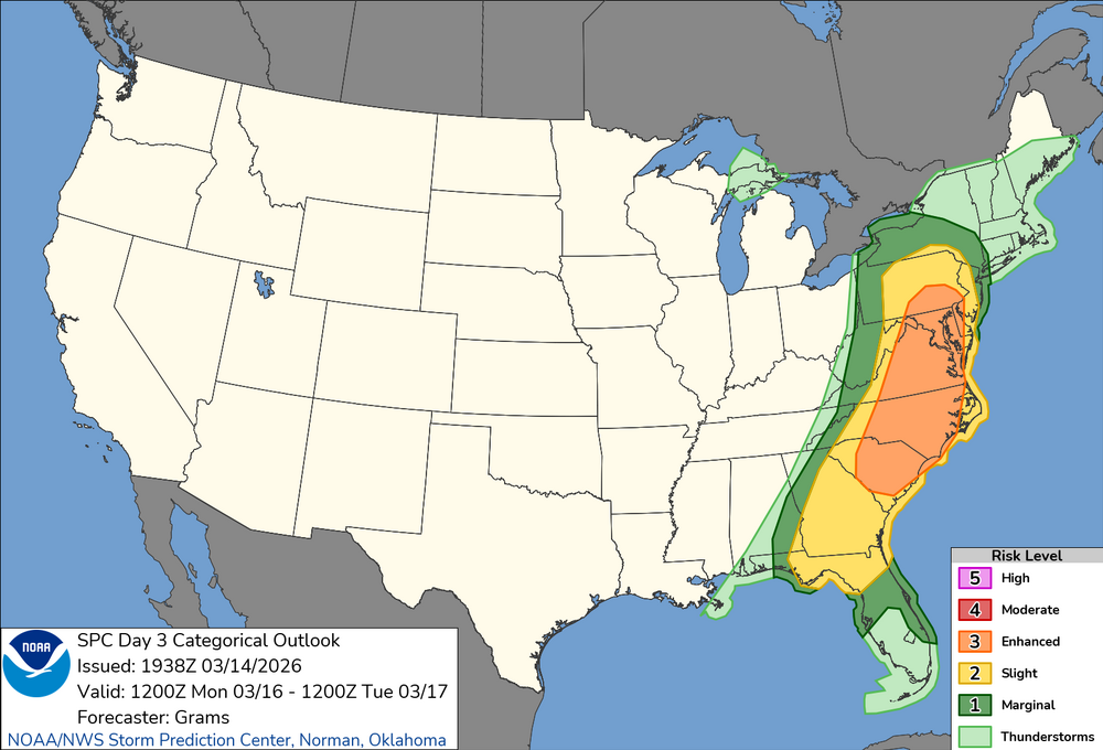
...Mid-Atlantic and Southeast... Primary changes this outlook are to add a 45 total severe probability along with minor northeast and southeast expansion to the categorical risk areas. Portions of the region, centered on SC to MD, may warrant an upgrade to a level 4/Moderate Risk in later outlooks. A large and deepening upper trough will eject east/northeastward out of the MS/OH/TN Valleys and across the Appalachians and into the Mid Atlantic/Northeast on Monday, with an expansive area of strong to intense wind fields aloft. A deep cyclone will move from Lower MI into QC, with an occluding cold front arcing southeast across the northern Appalachians, then south-southwest into the northern Gulf. This front will clear all but the FL Peninsula by Monday evening. Ahead of the front, seasonably rich low-level moisture characterized by 60s surface dew points will spread northward from the eastern Gulf/western Atlantic. Convection will likely be ongoing at 12Z Monday, low-topped along the Upper OH Valley to central Appalachian portion of the front to deep convection in the lee of the southern Appalachians to eastern FL Panhandle. A diurnal uptick in storm intensity, including potential for semi-discrete supercells ahead of the front, should occur from north FL to the Carolina Piedmont. Further intensification is anticipated midday into the afternoon as a confined corridor of moderate buoyancy likely develops just ahead of morning storms. Enlarged low-level hodograph curvature, in conjunction with favorable elongation of the mid/upper hodograph, should foster a mix of broken supercells south with line-embedded supercells in the reinvigorated QLCS north. With such intense 700-mb flow aptly timed with the diurnal heating cycle overlying rich low-level moisture, setup could yield an expansive severe weather day, including strong tornadoes and significant damaging winds. The degree of boundary-layer heating, as well as timing of convection that may outpace the front late D2 into early D3, will play key roles in how intense severe magnitudes may become. At present, the most likely corridor for significant/widespread severe appears centered on the eastern Piedmont to coastal plain from SC to MD around midday into the afternoon.
-
Slight and enhanced adjusted north and east
-
You mean in the discussion or did you hear something more specific? I didn't read it that way - it sounded more like they will continue to watch guidance and see what instability looks like.