All Activity
- Past hour
-
Beer
-
Snow?
-
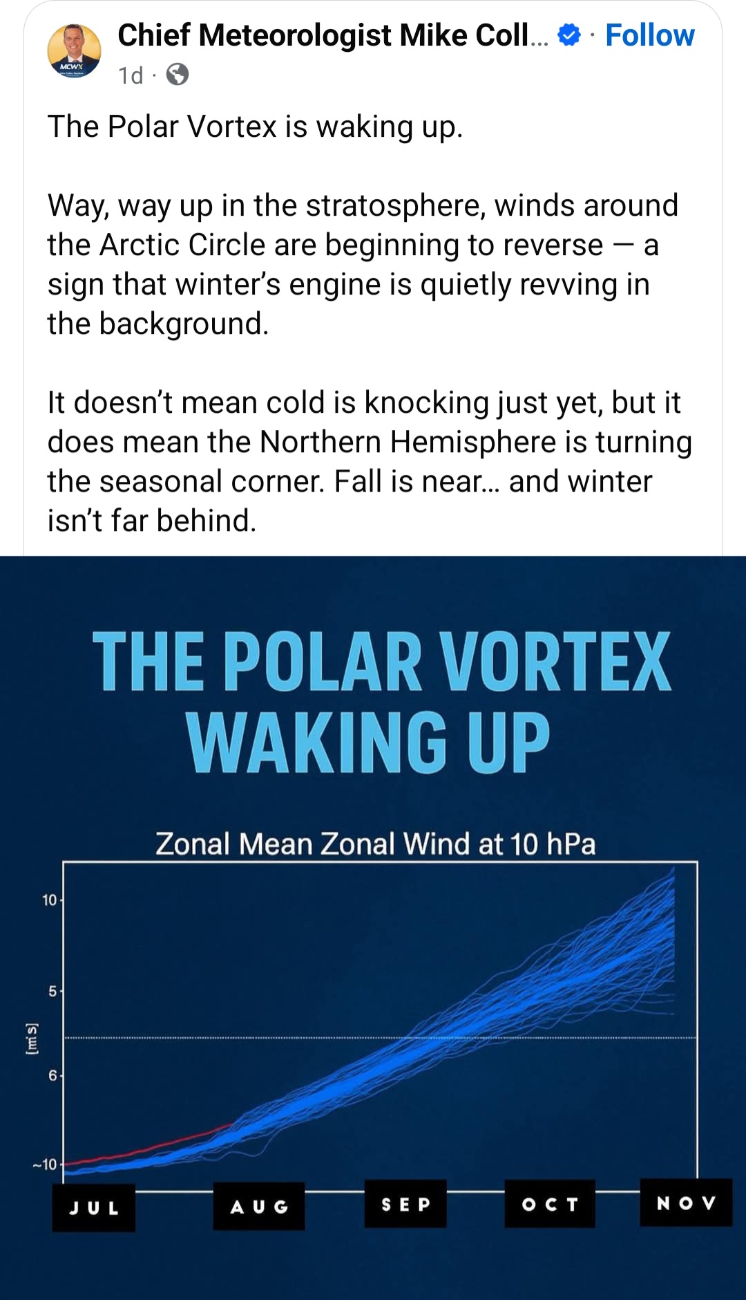
What the heck is the GFS doing..
-
 I wish it was a little warmer right now. 74 is ok but wish it was warmer
 -
 The second half of November is right around the corner! Love me some hoodie season.
 - Today
-
Why can’t every summer day be like this?
-
https://twitter.com/MikeMasco/status/1951616081518321994
-
Walk 18 each Saturday morning. 1st group out. Everyone else can wait. Needed a sweatshirt for first 6 holes this morning.
-
Thankfully aqi is down into the 30s here after 24 or so hours around 100. Sucks what you all are dealing with up north
-
 Models are looking hot in the long range though. Enjoy the fairly comfortable first 8 or 9 days of August. We're probably going to have a heat wave during the 2nd week of the month.
 -
 A break in the heat is now underway. The day started with another round of unseasonably cool readings. Low temperatures included: Bridgeport: 62° Danbury: 55° Farmingdale: 60° Islip: 60° New Haven: 61° New York City-Central Park: 63° New York City-JFK Airport: 62° New York City-LaGuardia Airport: 65° Newark: 62° Philadelphia: 64° Poughkeepsie: 52° White Plains: 58° Generally somewhat cooler than normal conditions will likely persist through the first week of August. It could briefly turn warmer for Monday and Tuesday before another somewhat cooler air mass arrives. The frontal passage will likely be dry for most of the region. There remain hints on the long-range guidance that a new round of heat could develop around August 10th. Parts of the region could see a return of 90° or above heat. The ENSO Region 1+2 anomaly was +0.6°C and the Region 3.4 anomaly was -0.2°C for the week centered around July 23. For the past six weeks, the ENSO Region 1+2 anomaly has averaged +0.48°C and the ENSO Region 3.4 anomaly has averaged 0.00°C. Neutral ENSO conditions will likely continue through the summer. The SOI was -8.01 today. The preliminary Arctic Oscillation (AO) was +0.017 today.
 -
We’re about to get a big hit it appears with heavy rain and much CTG lightning. BULLETIN - EAS ACTIVATION REQUESTED FLASH FLOOD WARNING NATIONAL WEATHER SERVICE CHARLESTON SC 443 PM EDT SAT AUG 2 2025 THE NATIONAL WEATHER SERVICE IN CHARLESTON HAS ISSUED A * FLASH FLOOD WARNING FOR... CHATHAM COUNTY IN SOUTHEASTERN GEORGIA... * UNTIL 645 PM EDT. * AT 443 PM EDT, DOPPLER RADAR INDICATED A NEARLY STATIONARY AREA OF THUNDERSTORMS OVER WINDSOR FOREST AND HUNTER ARMY AIRFIELD. AS MUCH AS 2.5 INCHES OF RAIN HAS FALLEN OVER THE PAST HOUR AND ADDITIONAL 1 TO 3 INCHES COULD FALL THROUGH 645 PM, RESULTING IN CONSIDERABLE URBAN FLOODING. PREPARE NOW FOR POSSIBLE CLOSED ROADS DUE TO FLOODING. HAZARD...FLASH FLOODING CAUSED BY THUNDERSTORMS. SOURCE...RADAR INDICATED. IMPACT...FLASH FLOODING OF SMALL CREEKS AND STREAMS, URBAN AREAS, HIGHWAYS, STREETS AND UNDERPASSES AS WELL AS OTHER POOR DRAINAGE AND LOW-LYING AREAS. * SOME LOCATIONS THAT WILL EXPERIENCE FLASH FLOODING INCLUDE... WINDSOR FOREST, HUNTER ARMY AIRFIELD, COFFEE BLUFF, MIDTOWN SAVANNAH, DOWNTOWN SAVANNAH, MONTGOMERY, GARDEN CITY, THUNDERBOLT AND VERNONBURG.
-
DFH 120 time. Limited release edition. The best yet imo. Might not age well like the other versions because of the the dry hopping, but it's so good no one would ever let it age anyway lol.
-
High of 77 after a low of 57. 76/58 now
-
Another massive weather system in TX, another wild swing...........and yet another MISS! Lucy is working overtime in Buda. The drought rages on. That was particularly heartbreaking. You could see the dark rain shaft but once again the life giving ship passes in the night.
-
Late September or early October out there today.
-

2025 Spring/Summer Mountain Thread
Maggie Valley Steve replied to Maggie Valley Steve's topic in Southeastern States
66 and moderate rain currently. -
 now that we hit august you can see the light at the end of the tunnel it wont be long now when you can wear your hoodie on a everyday basis..
 -
75° / 50°

-
It’s almost a given you can probably add 3 or 4 degrees to the current forecasted highs for this week. That’s sort of been a trend this summer.
-
77/57 at 4pm on August 2 in the MA. Hard to beat.
-
Euro AI goes bonkers with big heat over central/E NA and a few TC's staring you down. not sure how useful it is but if it's any kind of signal, we take

-
We sure did and the media was all over it. Low of 54, currently 75.


.thumb.png.4150b06c63a21f61052e47a612bf1818.png)