All Activity
- Past hour
-

2026-2027 Super El Nino
snowman19 replied to Stormchaserchuck1's topic in Weather Forecasting and Discussion
-
July 13 1933: An intense heat wave affects Grand Marais with a high of 90, extremely rare for that location. Most of Minnesota would exceed 100 degrees on this date. 1890: A tornado hits Lake Gervais north of St. Paul. People rush from St. Paul to help victims and look for souvenirs. One reporter notes that 'nearly everyone who returned from the disaster last evening came laden with momentoes (sic) denoting the cyclone's fury.' For Monday, July 13, 2026 1895 - A tornado struck Cherry Hill in New Jersey causing fifty thousand dollars damage. It also descended into the Harlem and Woodhaven areas of New York City killing one person, and finally ended as a waterspout in Jamaica Bay. (David Ludlum) 1975 - Dover, DE, was deluged with 8.50 inches of rain to establish a 24 hour record for the state. (The Weather Channel) 1977 - Lightning struck a key electrical transmission line in Westchester County of southeastern New York State plunging New York City into darkness. (David Ludlum) 1980 - Afternoon highs of 108 degrees at Memphis, TN, 108 degrees at Macon, GA, and 105 degrees at Atlanta, GA, established all-time records for those three cities. The high of 110 degrees at Newington, GA, was just two degrees shy of the state record. (The Weather Channel) 1987 - Unseasonably cool weather prevailed across the Midwest. Ten cities reported record low temperatures for the date, including Casper, WY, with a reading of 39 degrees. By way of contrast, record heat was reported in the eastern U.S., with highs of 93 degrees at Burlington, VT, and 101 degrees around Miami, FL. (The National Weather Summary) 1988 - There were just three reports of severe weather across the country, and just one record high temperature reported. Thunderstorms brought much needed rains to the Tennessee Valley area, producing nine inches at Senatobia, MS. (The National Weather Summary) 1989 - A thunderstorm at Albany, GA, produced 1.40 inches of rain in forty minutes, along with wind gusts to 82 mph. Afternoon highs of 98 degrees at Corpus Christi, TX, 110 degrees at Tucson, AZ, and 114 degrees at Phoenix, AZ, equalled records for the date. Greenwood, MS, reported 55.65 inches of precipitation for the year, twice the amount normally received by mid July. (Storm Data) (The National Weather Summary) Observances: 13 Mon National French Fry Day 13 Mon International Town Criers Day 13 Mon Beef Tallow Day 13 Mon Embrace Your Geekness Day 13 Mon Fool's Paradise Day 13 Mon National Delaware Day 13 Mon National No Splinters Day 13 Mon National Paul Day 13 Mon National Rock Day 13 Mon Gruntled Workers Day 13 Mon National Beans 'n' Franks Day 13 Mon National Barbershop Music Appreciation Day
-
I think the El Nino pattern is finally starting to take shape.
-
We picked up 0.09” additional which brings event total here to 0.97” and MTD 5.69”
-

2026-2027 Super El Nino
George001 replied to Stormchaserchuck1's topic in Weather Forecasting and Discussion
That’s certainly possible. Imo the issue my area (near Boston) has in super ninos isn’t just the temps, it’s temps + storm track (miller A setups which are more common in super Ninos are very prone to screwing us). In Michigan you have more buffer room with the temps than we do, and if we do get some MC forcing it could lead to more of an inside runner track which is good to you guys out west. -
Low of 63. I was surprised. Shockingly pleasant for mid-July in the swamp
-
 NBM argues BOS may not fall below 80F. BDL would have a legit shot of trying or even breaking their all time overnight low record
 -
I’d say most of central NC likely is above July normal amounts for the entire month and it’s still the first half of July. Yesterday’s rainfall was widespread and affected many areas that had missed out somewhat earlier in month. It seems the tide has turned on the drought looking forward with no signs of extended dry weather at all
-

Central PA Summer 2026 Discussion/Obs Thread
canderson replied to Voyager's topic in Upstate New York/Pennsylvania
Heat advisories up for Tuesday - not sure why they didn’t automatically extend through Wednesday. . -
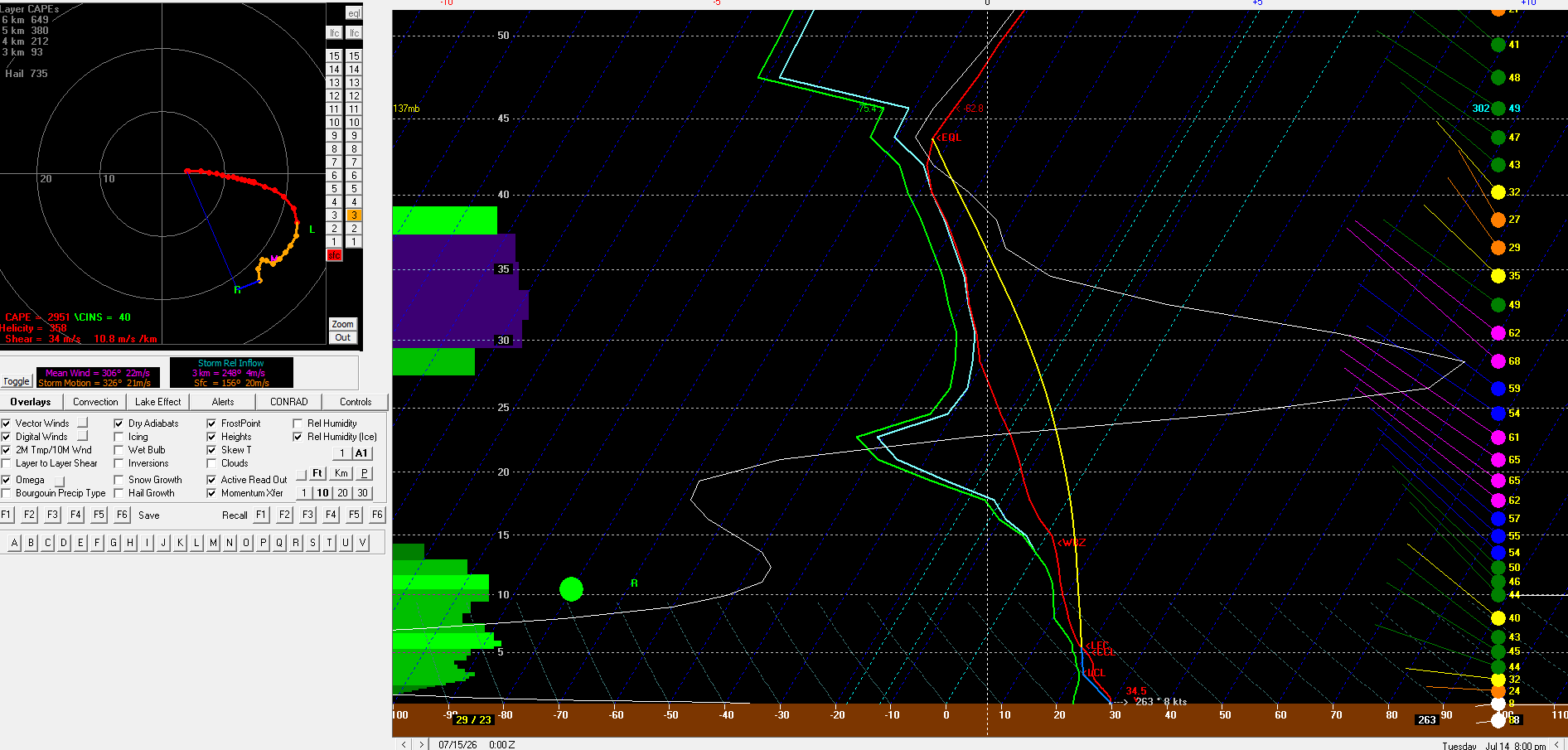
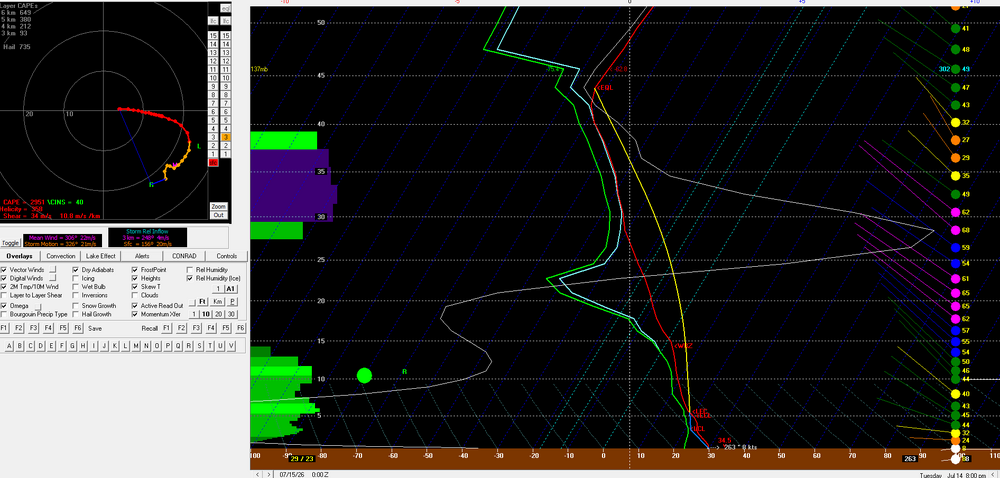
6z/13 NAM bufkit for BTV. About as impressive as an environment as you'll see around here out ahead of storms
-
-
Records: Highs: EWR: 100 (1966) NYC: 101 (1966) LGA: 99 (1966) JFK: 94 (1992) Lows: EWR: 57 (1940) NYC: 54 (1888) LGA: 58 (1990) JFK: 58 (1990) Historical: 1895 - A tornado struck Cherry Hill in New Jersey causing fifty thousand dollars damage. It also descended into the Harlem and Woodhaven areas of New York City killing one person, and finally ended as a waterspout in Jamaica Bay. (David Ludlum) 1922: The mercury hit 134 °F at Greenland Ranch in Death Valley, CA on July 10, 1913 the hottest reading of record for the World. The old world record has been revoked. Sandstorm conditions accompanied the heat. The high the previous day was 129° following a morning low of 93 degrees. The previous world record of 136 °F at El Azizia, Libya has been revoked The World Meteorological Organization (WMO)committee concluded that "the most compelling scenario for the July 13,1922 event was that a new and inexperienced observer, not trained in the use of an unsuitable replacement instrument that could be easily misread, improperly recorded the observation and was consequently in error by about seven degrees Celsius." Death Valley is now the Earth's Highest Temperature Record 1936: Mio, Michigan : The highest temperature ever recorded in Michigan: 112 °F. Dells, Wisconsin : The highest temperature ever recorded in Wisconsin : 114 °F. (Ref. Lowest and Highest Temperatures for the 50 States) (Ref. Additional Temperatures Listed On This Link) 1951: Rivers across eastern Kansas crest well above flood stage, causing the most significant destruction from flooding in the Midwestern United States at that time. Five-hundred-thousand people were left homeless, and 24 people died in the disaster. Click HERE for more information from the History Channel. 1964: Clouds, rain and a cool northeast wind holds the high temperatures in the upper 50s to mid 60s across West Michigan. The high of 59° at Grand Rapids, MI was only the second time in over a hundred years of record that the temperature did not reach 60° on a July day. Early morning lows dropped in ot the lower and middle 30’s across parts of the northern Plains. (Ref. Wilson Wx. History) 1975 - Dover, DE, was deluged with 8.50 inches of rain to establish a 24 hour record for the state. (The Weather Channel) 1977 - Lightning struck a key electrical transmission line in Westchester County of southeastern New York State plunging New York City into darkness. (David Ludlum) 1980 - Afternoon highs of 108 degrees at Memphis, TN, 108 degrees at Macon, GA, and 105 degrees at Atlanta, GA, established all-time records for those three cities. The high of 110 degrees at Newington, GA, was just two degrees shy of the state record. (The Weather Channel) 1982: Lightning struck a woman in Chesterfield County, VA . She was sitting on a metal swing set in her back yard, and though she could hear thunder, she did not go indoors. She heard a loud noise and felt pain. Lightning struck the swing set and traveled through her body to the ground. Her shoes were blown off her feet and she received burns on her back and legs. (Ref. Lightning - Virginia Weather History) 1987 - Unseasonably cool weather prevailed across the Midwest. Ten cities reported record low temperatures for the date, including Casper, WY, with a reading of 39 degrees. By way of contrast, record heat was reported in the eastern U.S., with highs of 93 degrees at Burlington, VT, and 101 degrees around Miami, FL. (The National Weather Summary) 1988 - There were just three reports of severe weather across the country, and just one record high temperature reported. Thunderstorms brought much needed rains to the Tennessee Valley area, producing nine inches at Senatobia, MS. (The National Weather Summary) 1989 - A thunderstorm at Albany, GA, produced 1.40 inches of rain in forty minutes, along with wind gusts to 82 mph. Afternoon highs of 98 degrees at Corpus Christi, TX, 110 degrees at Tucson, AZ, and 114 degrees at Phoenix, AZ, equalled records for the date. Greenwood, MS, reported 55.65 inches of precipitation for the year, twice the amount normally received by mid July. (Storm Data) (The National Weather Summary) 1993: Heavy rains of 3 to 5 inches in an hour caused flooding of streets and roads at Dodge City, KS. Standing water of one and a half to two feet was reported in southwestern Dodge City. In south central Kansas, heavy rains in Kiowa County caused widespread flooding and as much as 8 inches of rain was reported in portions of the county. The Rattlesnake Creek was out of its banks throughout the county and was reported to be as wide as five miles near the Edwards county line. Railroad tracks were washed out south of Kiowa County Lake. The water subsided around 5 AM the next day. Major flooding on the Mississippi River produced a record river crest at Quincy, IL of 32.3 feet; eclipsing the old record of 28.9 feet set in April 1973. At mid-month, only 5 of 28 bridges that cross the river into Illinois were open. (Ref. Wilson Wx. History) 1995: Many daily record high temperatures and three all time record highs were recorded as the deadly July 1995 heat wave continued unabated from the Midwest to the Atlantic coast. All time highs set included: Genoa, WI: 109°, Milwaukee, WI: 108°, La Crosse, WI: tied at 108°, Chicago, IL: 106°, Necedah, WI: 104°, Trempealeau, WI: 103°, Decorah, IA: 102° and Guttenberg, IA: 102°. Heat indices soared to well over 120° in many areas and close to 130° at Chicago, IL & Cedar Rapids, IA as dew point temperatures were in the upper 70’s to low 80’s. 553 people died in Chicago alone from the heat. (Ref. Wilson Wx. History) 1996: Annandale Weather Center had 2.11 inches rain in 24 hours from Hurricane Bertha. (Ref. Annandale Weather Records - KRIC)(Ref. More information about Hurricane Bertha) 2002: Winds up to 80 mph swept through Kingman, AZ damaged or destroyed dozens of homes. Four people were also injured from flying debris. In Chloride, winds were estimated at 100 mph which caused significant damage. (Ref. Wilson Wx. History) 2004: A violent tornado quickly developed across Woodford County, Illinois during the mid afternoon. This tornado was at F4 intensity as it demolished a manufacturing plant four miles west of Roanoke. Although 140 people were inside at the time, all escaped injury by reaching storm shelters a few minutes before the tornado's arrival. Steel beams and metal siding from the plant were found approximately three quarters of a mile east in a farm field. (Ref. Wilson Wx. History) 2008: A streak of 24 consecutive days (ending August 5th) of 90° or higher began on this date at Denver, CO. This shattered their previous record of 18 days established in 1901 and 1974. (Ref. Wilson Wx. History)
-
 Don't see this too often: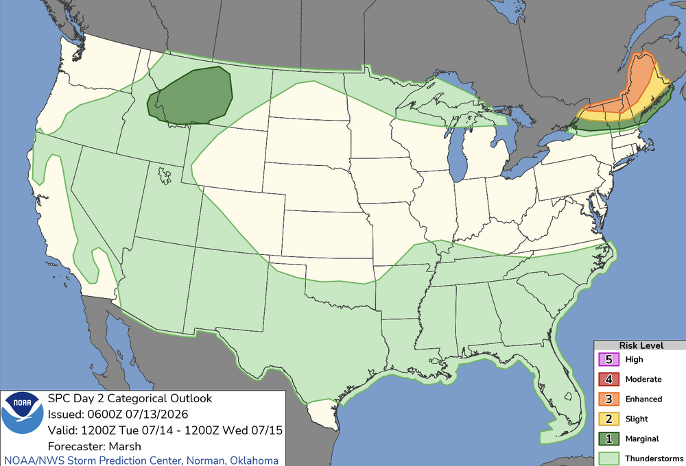
-
74 / 64 mid - upper 80s as ridge slowly builds in, centered by MN. Peak heat Tue - FRI with highest temps Tue / Wed upper 90s to some 100's into NJ South. Ridge pulls back and boundary fires up storms this weekend. Overall near to above normal the weekend to mid next week before next piece of het comes east and the Wstern Atlantics ridge builds into the Bermuda position towards the end of next week.
-
 While there are still some holdouts regarding global warming I think it is obvious that global warming is taking place. And yes the threat is looming..
 -
 At first glance the 500 mb height cinema's structural handling looks like roasting in the Lakes then shunting S of us.. but idiosyncratically air mass leads the SE Canadian SPC flex that happens later this week so a tranche of the heat burst (modeled 500 mb soaring to nearly 606 over IA!) gets pulled around that large scale change/leads. So... Tomorrow's about +19C at 850 mb with ample W to WNW boundary layer flow tumbling over the terrain... After a morning of full sun, we're definitely mixing through that layer. The adiabats would support a 1000 mb T of 96 ... so the 2-m slope T is probably close to 100F ... So NWS issuance of headlines. Using that as metric ..this is classic over topper. Probably falls short of a heat wave, but it will be intense for the probably thu Wed. Tuesday night lows may remain impressively elevated. This is different than the heat wave in that their be more breeze so that's a blessing.
 -
Well, not from an event like from my previous post, but DO have a drizzle/light rain/fog thing going on this morning. Temp in mid 60's, feels wonderful. High yesterday was 73.5 degrees, and that happened before noon, then it fell into mid-upper 60's and stayed there with rain on and off. Glanced at records to see where the 73.5 fell on the 'cool max' chart, lol nowhere close. Mind can't remember the event, but high on 7/13/1999 was 61 with about a 1/2" of rain. I don't think anything tropical was around then, although 1999 was a busy year.
-
Kind of shocked we don't have a general thunder area for Wednesday. I still think south of the Pike has chance for storms during the day and there would be a threat for strong/severe with any storms
-
Solar-nape season ends in 4 weeks.
-
Good disco from Marsh at SPC in the day 4-8 range Day 4-8 Convective Outlook NWS Storm Prediction Center Norman OK 0405 AM CDT Mon Jul 13 2026 Valid 161200Z - 211200Z ...DISCUSSION... All ensemble guidance suites are in broad agreement that the central US ridge will once again build westward in response to the development of a eastern North America long-wave trough during the forecast period. However, significant differences exist within and between ensembles regarding the timing and exact nature of this transition. At the start of the forecast period, a frontal boundary will be pushing south and west in the wake of a strong short-wave trough that moved across New England in the prior days. The trend over the past 48 hours is for this front to push farther south and west, bringing a continental dry airmass into New England and portions of the Mid-Atlantic. For example, several days ago ensemble guidance was in good agreement that the front would be draped across the Mid-Atlantic on Friday. Many, but not all, of the recent runs now push the front south into southern Virginia and northern North Carolina. This results in significant uncertainty regarding the potential severe weather environment on Friday (Day 5) across the Mid-Atlantic. For example, the GEFS mean temperature for Washington D.C. is 93F on Friday afternoon, while the EPS mean temperature is 102F. However, both ensembles have dewpoint temperatures in the 50Fs. Given the increasing uncertainty as to the location of the surface boundary on Friday and the overall quality of the severe weather environment, unconditional 15% severe probabilities for Friday are removed with this forecast. It is possible that severe probabilities may be reintroduced in later outlooks should it become apparent that the surface boundary washes out earlier than expected and quality low-level moisture is able to return sooner. That said, the front should begin to dissipate by Saturday in response to a mid-level trough digging southeast across the Great Lakes. This will allow rich boundary-layer moisture to advect northeastward into the Mid-Atlantic and southern New England. This increase in boundary-layer moisture and strong diurnal heating will allow for afternoon MUCAPE values between 1000-2000 J/kg, perhaps locally higher on Saturday and into Sunday. This unstable and vertically sheared environment will be ripe for thunderstorm/severe thunderstorm development ahead of any digging mid-level trough. However, as alluded to previously, the timing, magnitude, and number of these troughs is highly variable within the ensemble guidance, leading to too little confidence to pinpoint where and when unconditional severe probabilities should be added. As confidence in the timing, track, and strength of these embedded troughs becomes clear, severe probabilities will likely be needed somewhere across the region stretching from the Upper Midwest southeast into the Mid-Atlantic for one or more days. ..Marsh.. 07/13/2026
-
No, I do not want the bolded from this mornings LWX AFD - the 100s that is KEY MESSAGE 2...Forecast confidence decreases substantially late this week into the upcoming weekend, but the potential is there for both extreme heat and severe thunderstorms. Model guidance is in reasonably good agreement that the longwave pattern across the CONUS late this week into the upcoming weekend will feature troughing across the Pacific NW, ridging over the center of the country, and then troughing downstream across New England. Such a pattern will place us in NW`ly flow aloft. However, there`s considerable disagreement regarding the placement of individual shortwaves and their associated sfc fronts throughout that period. As a result, there`s a highly atypical amount of forecast spread for this time of year during that time window. Ensemble guidance has members showing highs anywhere from the upper 70s to the mid 100s each day Fri through Sun, with above average spread on Thu as well (mid 80s to mid 100s). So depending on which solution verifies, we could have anywhere from well below normal temps to record highs each day. Dry conditions are expected on Thu, but chances for storms start to increase for Fri, Sat, and Sun. Depending on how the pattern evolves, and which side of the frontal boundary we end up on, there could be a potential threat for severe thunderstorms. The forecast temp spread illustrates the unseasonable amount of baroclinicity that will be present, which should translate into unseasonably strong wind fields aloft as well. If we end up on the warm, unstable side of the boundary, the threat would likely be there for severe thunderstorms, with MCSs possible in NW`ly flow aloft. SPC currently has much of the forecast area highlighted in a 15 percent contour for severe thunderstorms on Fri, and WxNext2 AI guidance highlights additional threats for severe thunderstorms on both Sat and Sun. We`ll need to monitor trends over the course of the week, since this is a very conditional threat at the moment, given the atypically high amount of forecast uncertainty.
-
 shit, that is @weatherwiz daily attire (in the summer)
 -
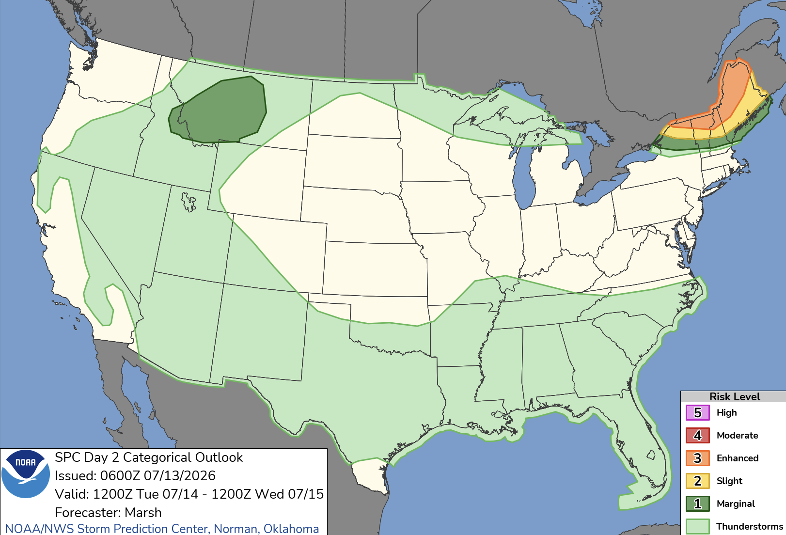
 Wow, SPC already in enhanced up in NNE
 -

2026-2027 Super El Nino
roardog replied to Stormchaserchuck1's topic in Weather Forecasting and Discussion
I feel like once you get into super Nino status that stronger might even be better here just because there should have a tremendous amount of moisture streaming into the country. Some of that is bound to try to make its way up this way like it did in 2015-2016. I guess if we have a record setting Nino then it’s something we’ve never experienced so technically there isn’t even an analog. - Today
-
The NBM shows WFO MQT reaching 99 degrees, which would place today in a 4-way tie for the all-time record (period of record since 1961). If downsloping can get the shoreline to 100 degrees, it will be only the 27th time 100 degrees has been recorded in the City of Marquette since the 1860s (including times with less reliable instrumentation and siting). The Ironwood WWTP site has not recorded a 100 degree temperature since the 1940s, while the Iron Mountain WWTP site has only reached 100 3 times since the 1940s (the IMT ASOS has never recorded 100 degrees F since it was installed in 1996). All of this to say, the level of heat today will likely (50+%) be on the level that most Yoopers would have to leave the UP to experience in their lifetimes. Overnight lows tonight only look to fall to the low to mid 70s, providing little relief for those without air conditioning.