All Activity
- Past hour
-
 I love those offers
 -
95/85 feels like 126. I think that is the highest feels like I have recorded. Walked outside and my glasses fogged over.
-

2026-2027 Super El Nino
Stormchaserchuck1 replied to Stormchaserchuck1's topic in Weather Forecasting and Discussion
Your Modoki Nino composite has cool anomalies in the east greater than warm anomalies in Nino 4. That's not accurate. Actually, a Modoki Nino typically has no negative anomalies anywhere in ENSO. +0.4c max in the west vs -0.6c max in the east is not an El Nino. -
Just eyeballing out my office window, it had improved a bit around 11am-12pm but has gotten thicker again since
-

2026 Mid-Atlantic Severe Storm General Discussion
wxmeddler replied to Kmlwx's topic in Mid Atlantic
Smoke can do a bunch of stuff but the two things that you see most often are: 1. Smoke can create differential heating on smoke vs. non smoke areas. Causing pseudo surface cold fronts. 2. Mid/Upper level smoke can absorb sunlight and transfer that energy to the surrounding environment; creating warmer mid-levels while also reducing surface heating. Both combined makes caps more robust than would otherwise be expected. -

E PA/NJ/DE Summer 2026 Obs/Discussion
JTA66 replied to PhiEaglesfan712's topic in Philadelphia Region
Pass. I threw out a crap ton of groceries the other week after the power outage. Can't afford to keep doing so -
 I would. Actually they were offering a thousand, hotel and transportation and flight out tomorrow. I almost bit
 -

2026-2027 Super El Nino
LakePaste25 replied to Stormchaserchuck1's topic in Weather Forecasting and Discussion
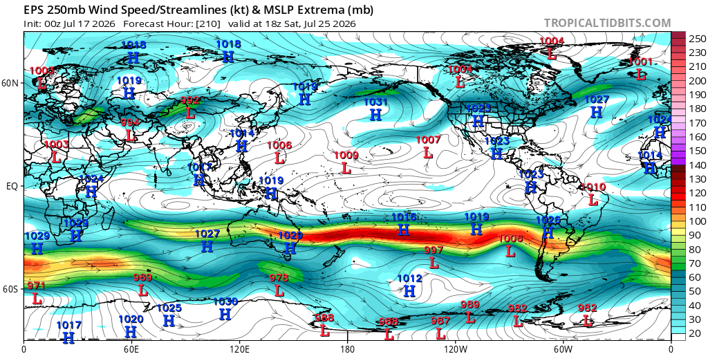
Jet extension is going full steam in the southern hemisphere winter, with copious amounts of snow in the Andes: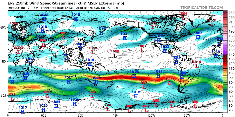
-
BWI VIS at 2mi. Not a huge improvement.
-
 As Ditty likes to say. "Finally some COC"
 -
 Looking even better now
 -
Will CAE finally reach 100? They’ve already reached 99.
-
 Sounds like I might not need to water our new plantings tomorrow. Glass half full.
 -
 134kt is pretty good for 7/20. A little snow and sleet mixed in too. KMWN 200458Z 28071G95KT 0SM -SHRA FG VV000 03/03 KMWN 200552Z 27067G78KT 0SM FG VV000 03/03 RMK SHRAB15E40 DZE40 KMWN 200652Z 28082G92KT 0SM -DZ FG VV000 02/02 RMK DZB30 KMWN 200759Z 28076G103KT 0SM -DZ FG VV000 01/01 RMK PRESFR KMWN 200955Z 27090G107KT 0SM -DZ FG VV000 02/02 KMWN 201150Z 27093G115KT 0SM -SHRA FG VV000 02/02 RMK SHRAB20 KMWN 201257Z 28099G116KT 0SM -SHRA FG VV000 02/02 KMWN 201355Z 28083G92KT 0SM -SHRA FG VV000 01/01 KMWN 201453Z 27079G95KT 0SM -SHRA FG VV000 01/01 KMWN 201555Z 27076G97KT 0SM -SHRA FG VV000 KMWN 201650Z 26076G104KT 0SM -SHRADZ FG VV000 01/01 RMK DZB30 KMWN 201750Z 27086G107KT 0SM SHRASN FG VV000 01/01 RMK DZE15 PEB15 SNB20 PEE45 KMWN 201854Z 27095G111 0SM -SHRASN FG VV000 01/01 KMWN 201952Z 280106G125KT 0SM -SHRASN FG VV000 02/02 KMWN 202052Z 280101G124KT 0SM SHRA FG VV000 02/02 RMK SNEPEB10PEE30 PK WND 280134/32 KMWN 202202Z 280103G126KT 0SM -SHRA FG VV000 02/02 KMWN 202250Z 28088G120KT 0SM SHRA FG VV000 02/02 KMWN 202345Z 28088G126KT 0SM SHRAPE FG VV000 02/02 RMK SHPEB40 KMWN 210050Z 28083G115KT 0SM SHRA FG VV000 02/02 RMK SHPEE35 KMWN 210055Z 29039G52KT 0SM FG VV000 05/05 KMWN 210155Z 30034G39KT 0SM FG VV000 06/06 KMWN 210251Z 28090G115KT 0SM 02/02 RMK T00200020 KMWN 210255Z 30039G54KT 0SM FG VV000 05/05 KMWN 210354Z 32034G43KT 100SM FEW/// SCT003 SCT030 05/05 RMK TPS LWR SCT055 W T00540045 KMWN 210459Z 32028G36KT 100SM FEW/// SCT003 SCT030 05/05 RMK TPS LWR FEW055 W T00540045
 -
Strong shear, lapse rates and high dews could counteract the lack of sun here especially with the fronts being nearby.
-
Pretty large enhanced risk area stretching back into NE OH tomorrow, on top of the broader slight risk area for MI / IN and the rest of OH. Seems to be some question as whether the pre-frontal trough vs. actual cold front will be the focus point though...
-
 Is it my imagination or does BOX update their forecasts less often than they did? Still a 7am discussion in there
 -
 You could consider checking out [url=https://retaildiscountprograms.online/#]visit the official website[/url] to understand how the process is handled.
 -

Central PA Summer 2026 Discussion/Obs Thread
Itstrainingtime replied to Voyager's topic in Upstate New York/Pennsylvania
-
Central PA Summer 2026 Discussion/Obs Thread
Itstrainingtime replied to Voyager's topic in Upstate New York/Pennsylvania
-
 An unseasonably strong shortwave trough amplifies as it swings across the Great Lakes region on Saturday as it advances towards the Northeast Saturday evening/overnight. As it does so, a cold front will push across the Great Lakes region during the day with a warm front lifting across the Northeast during the day on Saturday ushering in a warmer and more moist low-level airmass. Ahead of the trough features 40-45 knots of westerly mid-level flow with 30-40 knots of southwesterly flow in the lower-levels of the atmosphere which will contribute to 30-40+ knots of bulk shear, sufficient for storm organization. With the warm front approaching and a relatively uncapped airmass, extensive cloud cover along with scattered showers and thunderstorms are expected throughout the day and this does raise concerns about how much surface heating can occur and how much instability can build. Secondly, the timing of the rain and thunderstorms associated with a pre-frontal trough will be during the early evening, after peak heating. While instability would be a concern moving out of peak heating, as the warm front continues lifting through the region, the advection of higher theta-e air should help maintain what instability we have in place or even boost instability values a bit. CAMS are rather bullish in developing multiple rounds of thunderstorms across NY and PA with potential for multiple and concentrated swaths of damaging wind gusts and even potential for a few tornadoes given high helicity values. CAMS weaken this activity as it propagates across New England during the evening, however, given strong dynamics, increasing height falls, and at least weak instability (MLCAPE ~1000 JKG), localized damaging wind gusts and perhaps even an embedded tornado would remain possible as this activity crosses the region. As usual, the best potential for damaging winds or a tornado would be western sections. If instability turns out greater than forecast, there would be potential for a greater damaging wind threat across western MA and western CT.
 -
You could consider checking out [url=https://retaildiscountprograms.online/#]visit the official website[/url] to understand how the process is handled.
-
 Do they go down the aisle and select fatties?
 -
Need a big fat QLCS to blow and rain all the smoke out
- 1,035 replies
-
- 2
-

-

-
- severe
- thunderstorms
- (and 7 more)