All Activity
- Past hour
-
We got at least an inch last night in that last blast of snow in providence. Dunno if anyone will get a super accurate number but wow. And more snow Wednesday
-
it's a two wave system, wave 1 is definitely all snow for DC. Wave 2 night end as some mixed precip DC south but overall 90% of the precip is snow in DC on the AIGFS imo
-

Central PA Winter 25/26 Discussion and Obs
Mount Joy Snowman replied to MAG5035's topic in Upstate New York/Pennsylvania
Not sure if you know where to find them but here's a direct link to January's, just click the "Previous Version" link near the top to view prior months. Enjoy. National Weather Service -

Is we back? February discussion thread
Damage In Tolland replied to mahk_webstah's topic in New England
Aifs do -
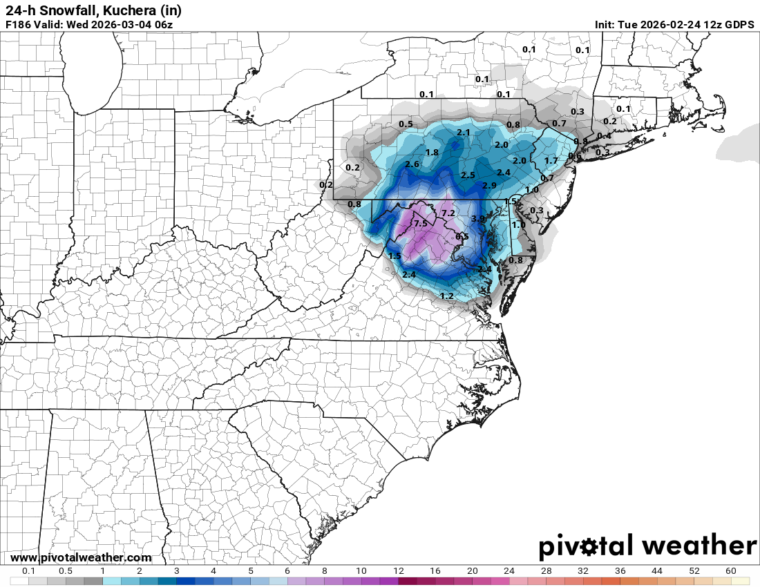
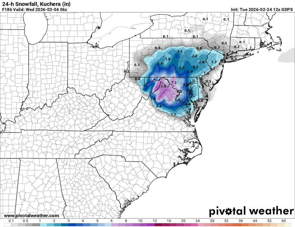
CMC has a nice little snow to rain event, drops 3-8" for most
-
Providence and Hartford are also wrong…should be 67.8 and 51
-
Gfs pretty active overall. Let’s make the public have a mental breakdown.
-

-

E PA/NJ/DE Winter 2025-26 Obs/Discussion
The Iceman replied to LVblizzard's topic in Philadelphia Region
I really only want .6” to get to 50” on the year then I don’t care. I won’t ever say no to more snow though. Regardless of white, the next two weeks are looking active. Could have some flood threats if it stays that way. -
That’s a very strong warm signal for being so far out, quite noteworthy IMO. Def something to keep an eye on to see if it trends towards something historic or just a run-of-the-mill early spring warm up.
-
Here you go:
-
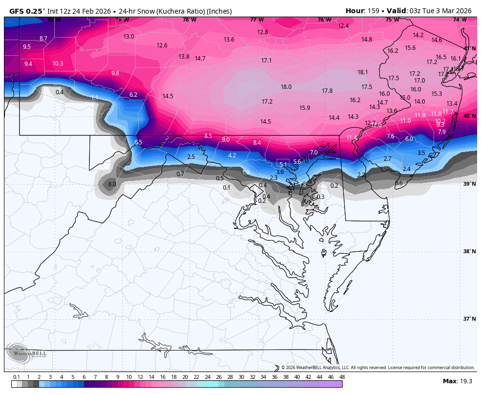
Gfs probably too cold on the southern side of this, could be a nice swfe for burbs and nyc though
-
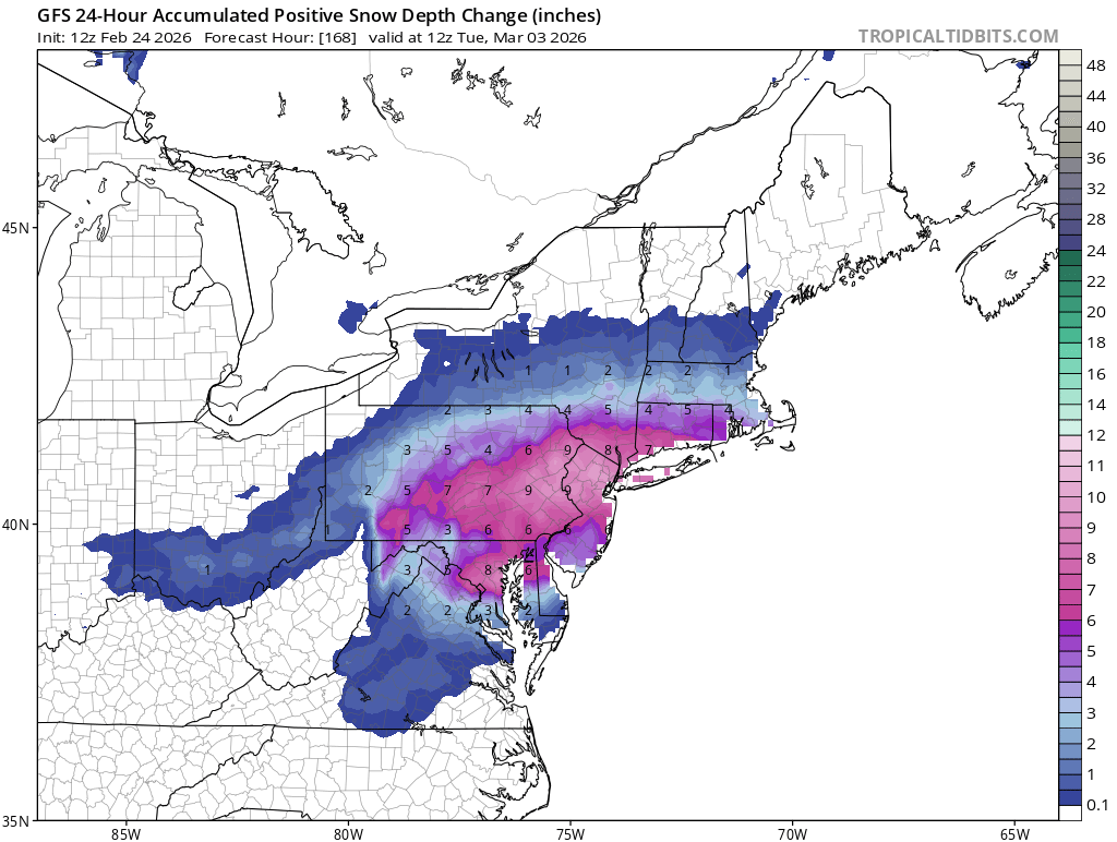
gets southern CT with 6"+
-
I have never had much interest in the thing later this week. I just don't see the win there...the flow is compressed and deamplifying with not enough ambient cold ahead of the wave...so in order to get enough precip we need a wave to amplify more to our west...but that would also mean warmer...it would take such a perfect thread the needle... But this wave next week I like. As much as I can like something at that range in a flawed but not horrible pattern anyways. Across most guidance it's been a little north but at day 5+ that's actually been where every eventual snow event was at that range...trend has been south from a week out...then back north some at the very end. The pattern looks meh on the means but if you dig in the TPV is displaced into a location that's worked late in the season before. It has some similarities to some of our late Feb early March snows of the past.
-
It looked to me GFS hits CT pretty good?
-
Well, I should have mentioned that when I posted I had little doubt that it would get shoved south as we approached it.
-
Oh wow! Please!! 4 days in the 60s a few near 70 lol
-
That is a dramatic tale. Glad no one died in a stampede! I had the same experience with people disbelieving. Times like that you get into weather chats with so many people lol. I'll probably never forget a random moment, standing in line at a 7-11 briefly talking to a dude who was in town from CO (and clearly very proud of his snow climo) who confidently told me how it was going to be nbd. He wouldn't believe me. I agree, once in a lifetime. For my location anyway, and my tastes, no winter has been better.
-

"Don’t do it" 2026 Blizzard obs, updates and pictures.
weatherwiz replied to Ginx snewx's topic in New England
The broad brush ranges certainly makes things much easier lol. But I can understand why there has been more of a movement to include more ranges and place greater emphasis on max/min zones. If you're in say an emergency planning vertical or DOT, landscaping, etc. the broad brush ranges often don't serve a great value (this is where the private sector come in because you can pay for greater local detail). Anyways very impressive to see that the short-term guidance and mesos absolutely nailed how this would evolve...literally to a T, especially with the evolution of the two bands and what would happen in between and even more impressive, the timing this would begin. These large events (or really any event) so there is much focus and so much sweat on analyzing QPF and QPF trends, snow maps and snow map trends and comparing from one model to another and one run to another run...that's a pretty terrible way to assess storm trends and evolution, IMO. In fact, on one of my lecture slides the professor even has stated in bold...these products do not explain why trends in storm track or precipitation intensity are there. This shall be another fun case study storm -
2/22-3 NE Blizzard: indices 1. PNA -1.2 2. AO +0.2 (neutral) 3. NAO +1.1 4-5. EPO/WPO: strongly negative (waiting on verification) 6. MJO inside circle both days 2/22: phase 3 2/23: either phase 3 or phase 2 (near border and thus waiting on verification) 7. AAM: -0.9 (moderate La Niñaish) 8. SOI: +6 9. PDO: negative 10. QBO (30 mb): strongly negative
-

Central PA Winter 25/26 Discussion and Obs
Jns2183 replied to MAG5035's topic in Upstate New York/Pennsylvania
I bit the bullet and downloaded state colleges record daily weather going back to 1894 and built a model to run 100,000 simulations. Got it to pass all over fitting tests, have a 99% percentile correlation, 94% interweek variability correlation, 98% intra- seasonal correlation based on auto-lag correlations. To have repeat of winter 1992-1993 and 1993-1994 back to back order not important it is a 1:1666 year event. To repeat the first four years of the 1960s 1:768 year event. Sent from my SM-S731U using Tapatalk -

Late February/Early March 2026 Mid-Long Range
Weather Will replied to WxUSAF's topic in Mid Atlantic
It is close to being good for many of us. Someone should start a thread Th. If it is still there.

-
I'd say we can toss Thursday now just about though in winters like this I would caution don't dump it totally. Because this is the type of winter it'll find a way to make a comeback and we get a couple of inches.
-
Funny thing about depth and snowfall totals. Providence where they had 38 inches has a max depth yesterday of 21 inches.
-
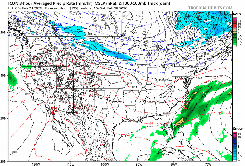
Nam and Icon try.. Icon bumped a good amount north at 12z