All Activity
- Past hour
-

December 2025 Short/Medium Range Forecast Thread
Matthew70 replied to John1122's topic in Tennessee Valley
What I’ve always seen is a -AO & -NAO always trump a -PNA. EPO is not as big of player when the other two are -. -
didn’t have much wind here, a couple gusts around 35mph surprising since this is usually a pretty windy spot, high was 52° at noon 36° now and no precip.
-

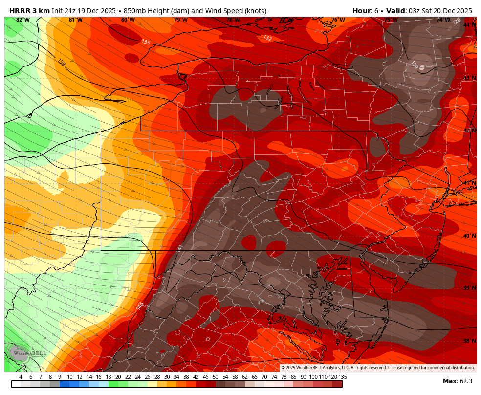
Central PA Winter 25/26 Discussion and Obs
MAG5035 replied to MAG5035's topic in Upstate New York/Pennsylvania
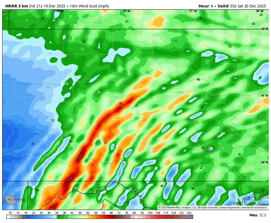
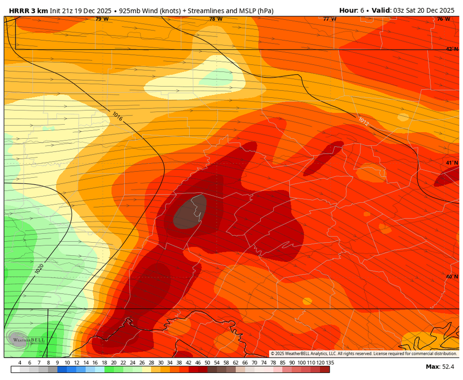
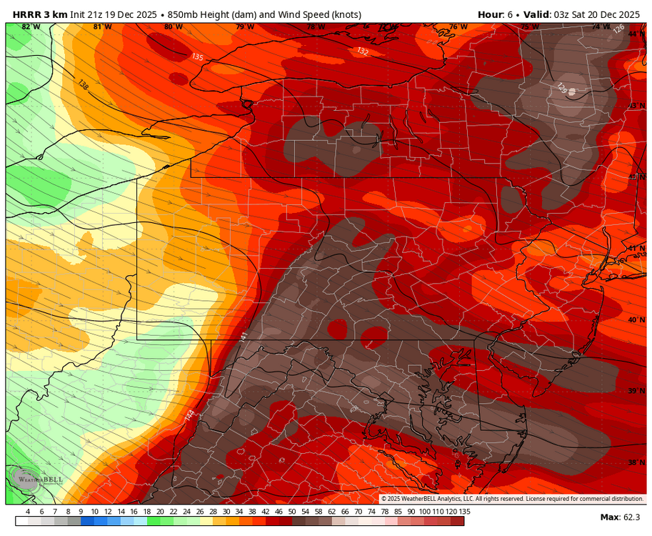
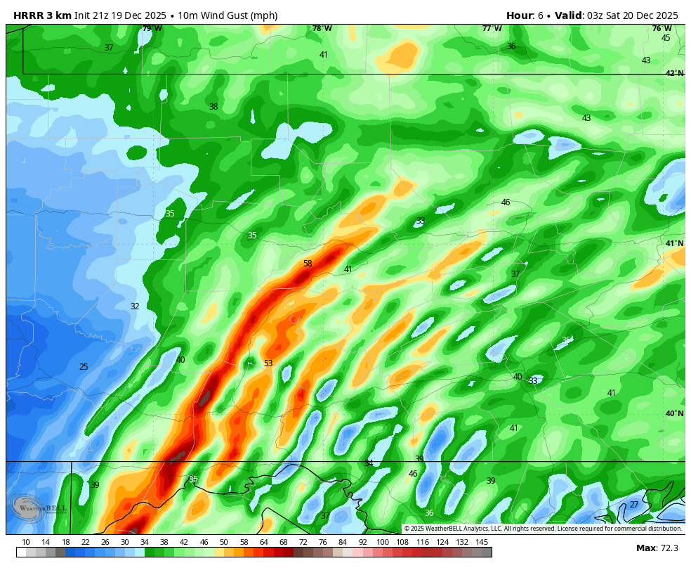
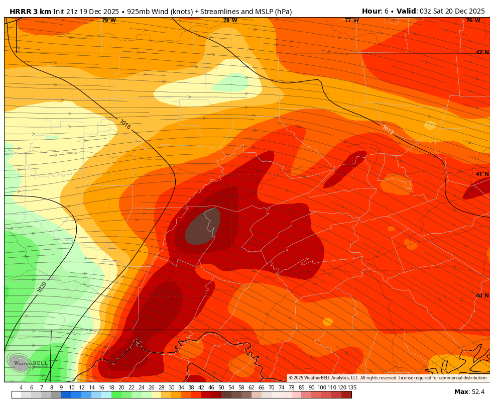
Somewhere in the ballpark of an inch of wind blown snow. There’s also been several snow squall warnings around as well with one currently stretching across I-99 from just north of Bellwood to Tyrone and extending over towards Lewistown The high wind warning worthy gusts in the actual warned counties may occur during the next several hours as near term guidance showing an enhancement of winds on and just east of the Allegheny Front centering on roughly the 7pm-midnight timeframe. Some HRRR images for 10pm Surface wind gusts (mph) 925mb winds (knots) 850mb winds (knots)
-
A report of snow out near Port Jervis.
-
See. I told everyone that this would happen and it is happening again.
-

Winter 2025-26 Medium/Long Range Discussion
Geoboy645 replied to michsnowfreak's topic in Lakes/Ohio Valley
This winter reminds me a lot of 22-23 just shifted 2 weeks earlier. Early cold and snowy period followed by a long period of storminess on the W Coast and warmth here in January. Hopefully this means we get a 22-23 like rally in February and it gets done by March 15th this time around. Madison and Green Bay recorded around 50 inches of snow in the Feb 15th to April 1st rally in 22-23. Something like that but a bit more spread the wealth and earlier would be nice to say the least. -

December 2025 Short/Medium Range Forecast Thread
Golf757075 replied to John1122's topic in Tennessee Valley
Just eye candy, but impressive.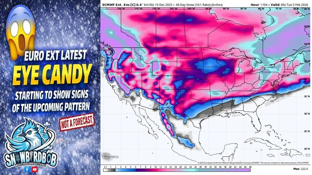
-

E PA/NJ/DE Winter 2025-26 Obs/Discussion
Birds~69 replied to LVblizzard's topic in Philadelphia Region
Down to 35 F here, dropping and with the winds, just beautiful... -
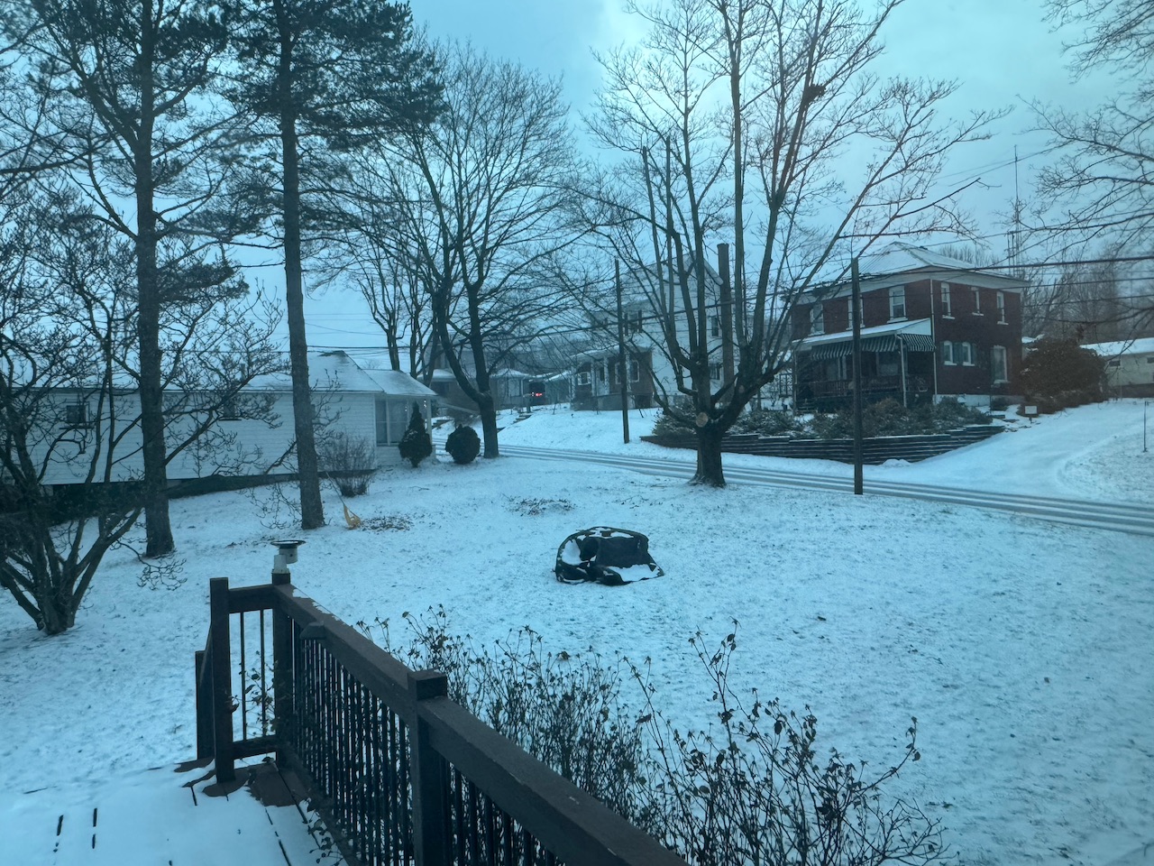
Pack was obliterated here. Only a few plow piles left in the most shaded area of the neighborhood.
-
Some flakes for the 23rd
.thumb.png.69d39eb5f0e45efa6beb684f50cd82ae.png)
-
Same here.
-

December 2025 regional war/obs/disco thread
Typhoon Tip replied to Torch Tiger's topic in New England
It can split NNE and SNE ( not sure i think you're in VT ?) anyway, the storm track can end up flopping like an unmanned fire hose because both tracks are supported ... sort of ending up between cutters and transfers... SNE rolls dice ending up shafted or SWFE 50/50 .. while mix gets to PF, and then it's powder snow up in CAR ... It's not impossible for easterly NAO's to even swash a warm sector or two. No coincidence we're seeing the operational runs flopping around as they have been. -
Ugh! Had to reset the timer for the Christmas lights. These power outages tend to be a bit inconvenient.
-
Model guidance brewing some big warmth for late next week. GEFS, GEPS, EPS all have it. Most of the country is modeled to be above freezing on Xmas. Our warmest day might come right after. Still waiting for a positive surprise in the mid-range...
-
December 2025 Short/Medium Range Forecast Thread
Golf757075 replied to John1122's topic in Tennessee Valley
What will build my confidence is when the epo turns negative, which may take some time but we will go from there. An ao/nao being negative can trump an awful pacific sometimes. -
Looks like low 50s for Xmas. Probably 60 or so the day after. Is what it is. Not hating it tbh.
-

December 2025 Short/Medium Range Forecast Thread
Carvers Gap replied to John1122's topic in Tennessee Valley
I think models are in a huge state of flux right now. They were wrong about the Baja lows. They are wrong about over-doing too many NW Pac lows. They could be overdoing the Aleutian and/or NAO and/or AO HL blocking. We have seen modeling miss on HL blocking at exactly this time of year, but we have seen it score. Just too early to tell. -
December 2025 Short/Medium Range Forecast Thread
Carvers Gap replied to John1122's topic in Tennessee Valley
I am mainly confident, because recent Nina climatology suggests there will be 10-14 days of very cold temps sometime between week 2-4 of January. Plus, this seems to be one of those years where warm-ups get shortened as they draw closer. We are in the "warm-up" which was originally modeled to be anomalous. This morning, I was running in 30+mph winds with wind chills in the 20s. If the more aggressive models are correct, the warm-up may be confined to Dec 24-28th. Might be the most talked about warm-up ever to only amount to about 120 hours of AN temps. LOL. I hope that is what happens!!! I am pulling for the NAO to occur, because I am tired of talking about the MJO (no offense meant to those who like it...it is effective). So far, this has fit Nina climatology like a glove.... -

Pittsburgh/Western PA WINTER ‘25/‘26
colonel717 replied to Burghblizz's topic in Upstate New York/Pennsylvania
Looks like this is back building again. I missed out most of the afternoon squalls. Hope these ramp up and head due east or go just south of me.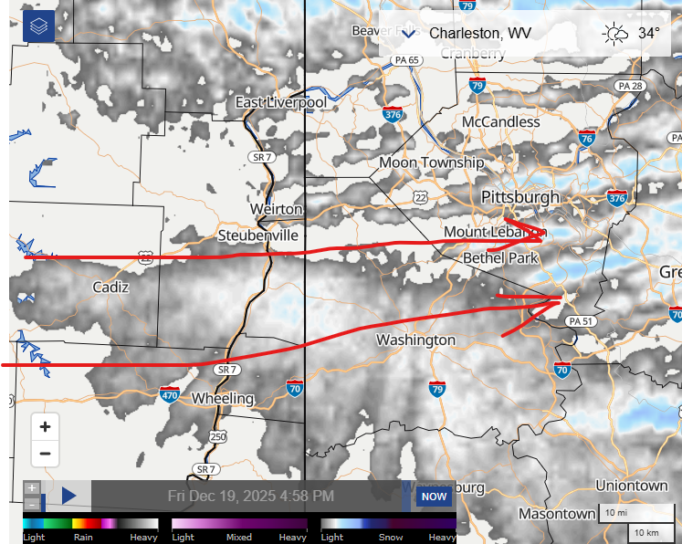
-
Gusted to 49mph in Syosset with the line
-
Meh...72" is like being fringed!
-
Down to 38 . Hopefully snow shortly
-
Hopefully it weakens as it heads east. 6 hours without power now.
-
GFS AI looks good. GFS op barely has precip lol.


.png.585601bd95dff62a1d3ed934af2a2c75.png)


