All Activity
- Past hour
-
Also not that it matters a ton (also it's being sunset soon) - the SREF maps over on the SPC page are already showing a mean Derecho Composite of 3 for part of Thursday afternoon/evening.
-

Junorch obs and discussion 2026
CT Valley Snowman replied to Damage In Tolland's topic in New England
I might be the Stein epicenter here. Local PWS stations are like .10-.15 MTD after last night's screw job. Everything is getting torched. -

2026-2027 Super El Nino
snowman19 replied to Stormchaserchuck1's topic in Weather Forecasting and Discussion
-
Digging this windows open weather.
-
Upper 30's/40's across the area this morning. Was a nice day yesterday with highs in the 70's, but breezy NW winds. Low dews. 70's today with scattered shwrs/stms, then back to cooler wx with more rain possible Wed.
-
I *will* say that the NCAR AI maps are VERY robust for Thursday - but they do tend to look at lot more serious than CSU and CIPS in general. So take with a grain of salt.
- 746 replies
-
- 1
-

-
- severe
- thunderstorms
- (and 7 more)
-
This is what LWX had in their AFD this morning re Thursday Beginning Thursday, a strong surface low will push east past the Great Lakes with a stemming cold front that will push across the Northeast and Mid-Atlantic. This cold front could result in multiple showers and thunderstorms throughout the region, with some becoming severe. There is already a 30%-45% severe probability noted in NCAR`s AI model, and a 15%-30% severe probability noted in CSU`s ML model. Timing and exact hazards are still the primary uncertainties being 5 days out, but early markers are definitely showing an early widespread severe risk with this system.
-
06z RRFS suggests that this may be more of a Thursday event for us, blowing up a cell right over the metro by midday. will be interesting to see what the 12z suite thinks, but I could see the d4 risk being shifted back west some
.thumb.jpg.9146b6d9aa092219118fa3de84d0e33c.jpg)
-
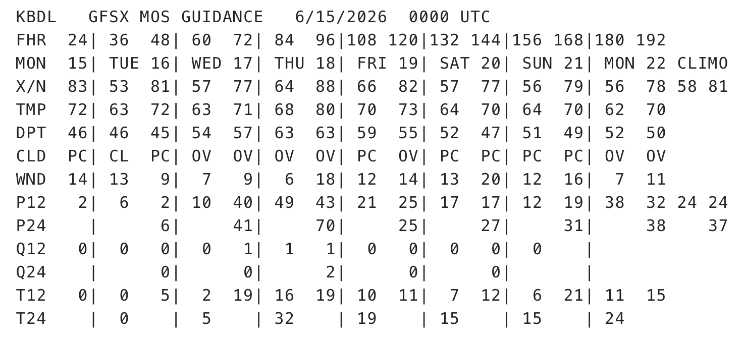
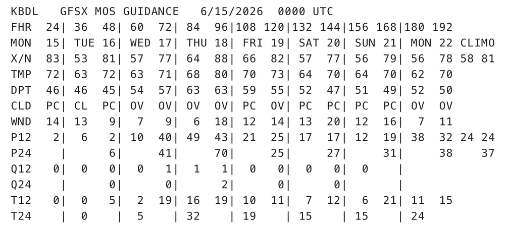
Extra log on the fire this week at BDL
-

E PA/NJ/DE Summer 2026 Obs/Discussion
The Iceman replied to PhiEaglesfan712's topic in Philadelphia Region
2.10" last night. We got trained on from 10:30 - 12:30. Lots of wind damage around the township too. Several trees down. -
Truth! Severe weather around here is a perfect example of what tiny factors can change about an event...no two events are the same even with seemingly nearly identical parameters. Snow gets all the glory of forecast busts - but I really think severe weather busts are MUCH more finicky.
- 746 replies
-
- 1
-

-
- severe
- thunderstorms
- (and 7 more)
-

2026-2027 Super El Nino
LakePaste25 replied to Stormchaserchuck1's topic in Weather Forecasting and Discussion
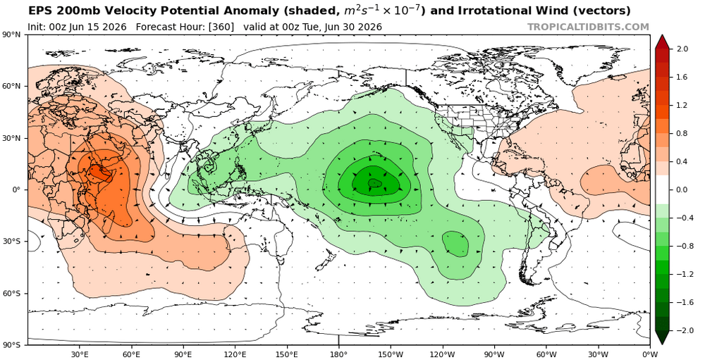
Ensembles really want to hang onto this W pac forcing too. Competing Nina influence for the foreseeable future.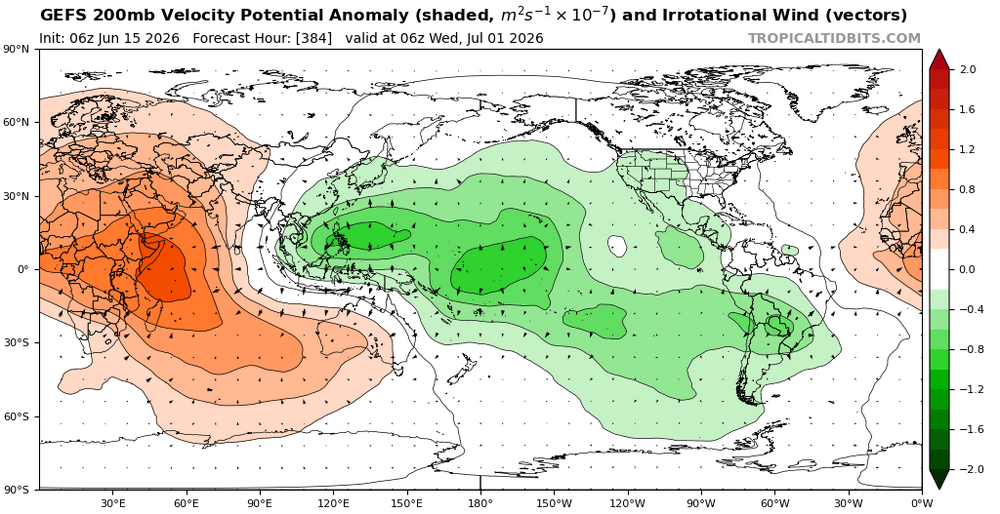
-

Junorch obs and discussion 2026
Damage In Tolland replied to Damage In Tolland's topic in New England
Maybe lack of rain too . Not washing it away -

2026 Mid-Atlantic Severe Storm General Discussion
Eskimo Joe replied to Kmlwx's topic in Mid Atlantic
I'm kind of in the same boat as you. Still, we've seen what marginal surface instability and good dynamics can do in these parts. -
Lucked into a couple of good storms last night and ended up with .96” for the night and 1.88” for the month.
-
I realize there's a drought meme popularity that's vying for second place behind this other sweeping notion that some grand Disclosure ( the extent of which assuredly will trigger an ontological shock ) is looming... But so far, at least around here? absolutely 0 physical manifestation of any problem with water deficit. We go through this every year - promoted by U.S. Drought Monitoring and their primary sales agent, Kevin, emceeing a desiccation presentation... And, we also read this every year, too: "We go through this every year" Yet, y'all just can't wait to pack the reception hall for his brilliant geophysical Ted Talk on the matter... I guess it's an easy audience. We become stimulation junkies at a species level. In the absence of even vaguely legitimate reasons for concern from just about any agency for triggering at all, we're creating urgency.
-
You hate to waste a summer month with those temperatures.
-
Whopping. 05" last night. The ground almost got wet! Wet, I tell you!
-
Even despite the factors this potential even has going for it - I'm kind of "meh" on it for now. Not necessarily truly meh - but I'm just not feeling it so far. Will see how things look once it gets closer in time. I suspect we won't really have any SOLID clarity until 11am the morning of lol.
- 746 replies
-
- 1
-
-
- severe
- thunderstorms
- (and 7 more)
-
Nice. We had some decent wind but nothing too crazy. We did pick up much need rain 1"+ - it has been dry here since Memorial Day weekend.
-
Actually looked at the forecast, and my high temps are still above normal this week. I know inland has "higher" expectations with AHATT
-
Great, now there is a whole lot of media hype about the "cold blob" of water south of Greenland. Isn't that this the manifestation of the AMO heading towards the negative phase?
-

E PA/NJ/DE Summer 2026 Obs/Discussion
LVLion77 replied to PhiEaglesfan712's topic in Philadelphia Region
Looking at the precip map, the Philly region south of Lansdale down to Wilmington DE did exceptionally well. The southern Poconos also did very well too. The Lehigh Valley and the far northern bucks and Montgomery counties did poorly. -

2026-2027 Super El Nino
40/70 Benchmark replied to Stormchaserchuck1's topic in Weather Forecasting and Discussion
I was just thinking that yesterday on a totally anecdotal level...the big heat this month hasn't seemed Nino like. Glad the empirical data jives with my hunch. -
Beautiful breezy morning here, I’m off work so the kids and I have been on the WV route 9 bike trail. June often delivers nice weather more than I expect.


.thumb.jpg.ad3a2e31d30aff035044689b311a0540.jpg)
.jpg.f05bdd5bcc7794e75b3ee9d9df3fafb7.jpg)