All Activity
- Past hour
-
Already done with the early bird special at Dennys? Bedtime for you soon
-

2025-2026 Fall/Winter Mountain Thread
BlueRidgeFolklore replied to Buckethead's topic in Southeastern States
I feel like we’ve seen this movie a dozen times. This will correct NW over the coming days. If you’re in the Southern Mountains from Highlands to Saluda, get ready. -
Yea, wind was a little sharp at times, but overall a very Colorado-style day.
-
I can barely remember my pin for my ATM card. When you get old and feeble the memories of past storms all bleed together. The snows from 1899 and 2016 are one in the same to me
-
Right there with you. It ain't right, I'm telling ya...a whole generation is going through their childhood without knowing what it's like! I was blessed to have a childhood with 1996, 2000, 2003, and 2006. But this time? I mean dang over a decade you'd think ONE time we could get something more than an inch or two to work out. And our yards in particular! There's some imaginary snow shield or something, smh I just don't get it, smh Yeah this one is far from resolved but you can't but feel like "Here we go again" when you see a model showing an unfavorable solution. Even the dang Ninos we've had in 18-19 and 23-24 didn't do jack diddly SQUAT. I mean we likely have another one coming next year so maybe we can try that again but man...rough!
-
Not putting any stock into the GFS rn. It’s scored the lowest outta all the models. .
-

January 2026 regional war/obs/disco thread
TauntonBlizzard2013 replied to Baroclinic Zone's topic in New England
Snowing right now -
18z gfs
-

Winter 2025-26 Medium/Long Range Discussion
DocATL replied to michsnowfreak's topic in Lakes/Ohio Valley
Carolina crusher. -
Which leads to the inevitable question Stormtracker continues to ponder...Do you feel lucky punk? Well do ya'?
-
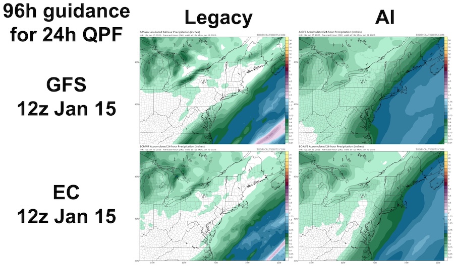
 Quoted the above to help consolidate our tallies and impressions into the same thread for rolling reference... I agree: for Jan 18-19 2026 event, my impression was the AI models crushed legacy physics models in the 2-5 day range... we had multiple legacy models and cycles showing 0 QPF beyond far southeast MA vs. AI models showing with remarkable consistency solutions like those below. Within 24-48h, legacy models including EC/GFS and hi-res models NAM/HRRR etc were helpful to refine details. Can anyone suggest an objective and easily accessible measure of verification if not QPF? Here are CoCoRaHS QPF estimates for 7a-7a, compared to guidance below, all 24h ending 12z 1/19/2026:
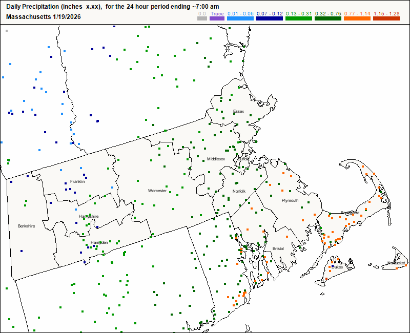
-
You should try and figure it out
-
Wasn’t the GFS predicting a crippling blizzard for this past weekend 100 hrs out?
-
Jeez, I have no idea where to go on that website. Just show us the money panels.
-

MO/KS/AR/OK 2025-2026 Winter Discussion
rockchalk83 replied to stormdragonwx's topic in Central/Western States
The GFS has been trash with this. It's inconsistent within itself and its ensembles. -

January 2026 regional war/obs/disco thread
ORH_wxman replied to Baroclinic Zone's topic in New England
My guess is we’ll get something or it won’t be that close. -
Wow, 2 feet for my area. Lock it in.
-

January 25/26 Jimbo Back Surgery Storm
Thrasher Fan replied to Jimbo!'s topic in Southeastern States
As we currently stand, the NE mets are doing a fine job of ignoring how flat the HP is over them. -
What does a Ji do on a day like this? Is this blue enough? Does the high wear off after each run? Too weak? Too strong? End up on the news pitching tent?
-
True
-
100% chance of it being really cold at least!
-
Anyone interested in maps from 18z GGEM, you can get them at the link below. Just be prepared to go back in time when you look at them. https://meteocentre.com/numerical-weather-prediction/forecast-systems.php?lang=en&mod=cmc_gdps
-

Possible Record Breaking Cold + Snow 1/23 - 1/25
Prue11 replied to TriPol's topic in New York City Metro
We have to hope the cold air coming in Friday isn’t as strong as forecasted. Less suppression -
This storm has me nervous lol. Getting close to something good, but I fear I may be a bit too north. It's still early though. I think you Tennessee folks may be in for a nice treat!
-

E PA/NJ/DE Winter 2025-26 Obs/Discussion
Mikeymac5306 replied to LVblizzard's topic in Philadelphia Region
In all seriousness, at least we'll wait for the NAM to get in range before considering a thread on here. Lot of details still need to get locked in.