All Activity
- Past hour
-

12/14: Sunday funday? Will the south win again?
nw baltimore wx replied to TSSN+'s topic in Mid Atlantic
For anyone wishing for LWX to issue warnings, we almost always do better when they play catch-up. I don't need to see my house in the pink map. Just let it snow! -
Yeah, SNE has been in rough shape as well. C/NNE have done much better. Tracks have not been right for the stretch of coast from NJ to LI to SEMa.
-

December 2025 Short/Medium Range Forecast Thread
Daniel Boone replied to John1122's topic in Tennessee Valley
Good,valid point. Post this in the Main Forum and you'll have many going Nuts over there ; particularly the Warmanista and GW brainwashed One's. They'd probably justify the Model's doing that. Fact is, GW is real to a degree but, the Cause and Forecasted Rate is off. Not to say your Post is about GW, just giving an Opinion on why you're right on your Suspicion. -

Saturday night/Sunday 12/13-12/14 Jawn
Duca892 replied to Ralph Wiggum's topic in Philadelphia Region
Went to work expecting around an inch for Whitehall and leaving work and expecting around 2-3in. Nice nice -
Really coming down here now, starting to accumulate on grass/vegetation, not much on the roads yet though. Temp is just below 32f, so hopefully it starts dropping soon and we see some higher ratio stuff move in
-

Pittsburgh/Western PA WINTER ‘25/‘26
meatwad replied to Burghblizz's topic in Upstate New York/Pennsylvania
URGENT - WINTER WEATHER MESSAGE National Weather Service Pittsburgh PA 1141 AM EST Sat Dec 13 2025 OHZ057-058-PAZ021-WVZ002-140215- /O.UPG.KPBZ.WW.Y.0024.251213T1800Z-251214T1800Z/ /O.EXA.KPBZ.WS.W.0008.251213T1800Z-251214T1800Z/ Muskingum-Guernsey-Allegheny-Brooke- Including the cities of Pittsburgh Metro Area, Wellsburg, Zanesville, Follansbee, and Cambridge 1141 AM EST Sat Dec 13 2025 ...WINTER STORM WARNING IN EFFECT UNTIL 1 PM EST SUNDAY... * WHAT...Heavy snow expected. Total snow accumulations between 4 and 7 inches. * WHERE...In Ohio, Guernsey and Muskingum Counties. In Pennsylvania, Allegheny County. In West Virginia, Brooke County. * WHEN...Until 1 PM EST Sunday. * IMPACTS...Travel could be very difficult. PRECAUTIONARY/PREPAREDNESS ACTIONS... Please report snow or ice accumulations by calling 412-262-1988, posting to the NWS Pittsburgh Facebook page, or using X @NWSPittsburgh. && $$ -

12/14: Sunday funday? Will the south win again?
winter_warlock replied to TSSN+'s topic in Mid Atlantic
True.. lol
-

Saturday night/Sunday 12/13-12/14 Jawn
Albedoman replied to Ralph Wiggum's topic in Philadelphia Region
Folks, I have stuck to my guns. This map says it all - South Mtn special with banding. Lollipops of more than 6 inches across S Mtn region. Be prepared for a winter storm warning to be issued. for some areas during the storm event. This is a "now" event -lets see what happens I go by physical geography, not by dam roads as do the models. Bear Creek is going to love this storm -
The 12z RGEM would be pretty interesting for the western lakeshore and secondary snowbelt at times overnight tonight through Sunday! It also looks plenty snowy for the inland core snowbelt.
-

December 14th - Snow showers or Plowable snow?
moneypitmike replied to Sey-Mour Snow's topic in New England
Even managed to get me close to the 2-3 range. I wonder if any of that is from stuff falling today. -

Saturday night/Sunday 12/13-12/14 Jawn
RedSky replied to Ralph Wiggum's topic in Philadelphia Region
The era of it always snows at night -
Over the weather…. You suck as a human being, but you are smarter than that. You damn well know this is about more than just weather, it’s about how you treat people. You have a superiority complex and put kind hearted people who yes do wishcast a bit down and call them stupid. Fuck you
-
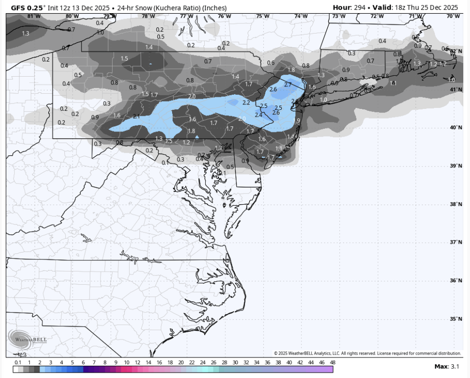
Gfs says what big warmup. Also 2 storms in the long range
-
GFS is really funny. two events on Dec 25 and 27

-

Central PA Winter 25/26 Discussion and Obs
MAG5035 replied to MAG5035's topic in Upstate New York/Pennsylvania
The HRRR is suggesting that right at the very beginning when it precip arrives into the LSV. I would think it would be brief if it happens. Surface starts above freezing but 850mb and 925mb level are plenty cold to start the event and cool further as the event progresses. I think this event should get the rest of the LSV solidly on the board in terms of first synoptic snowfall. -

December 14th - Snow showers or Plowable snow?
dendrite replied to Sey-Mour Snow's topic in New England
Did mekster draw this?
-

2025-2026 ENSO
vegan_edible replied to 40/70 Benchmark's topic in Weather Forecasting and Discussion
for real. its never EVER that serious, sorry that he went off on you -

December 14th - Snow showers or Plowable snow?
JKEisMan replied to Sey-Mour Snow's topic in New England
HREF looks good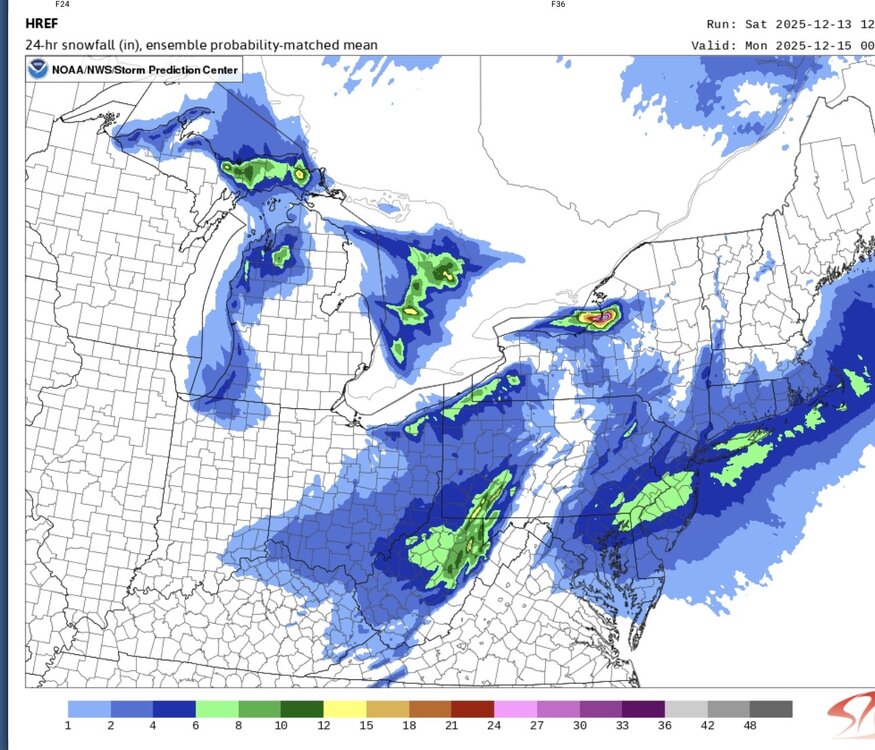
-
 IF this possible moderate " snow event " pans out and is the real deal that makes most people in this forum ( besides Snowy ) Happy then no offense to Anthony or anyone else but I suggest that WeatherGeek2025 ,,,, be the person to start the next storm discussion as well and IF he does good again , heck he can do it for the rest of the winter !!!!
 -
I wouldn’t worry about that too much. I’m in eastern PA and earlier this week we had an event that the HRRR said would be all or mostly rain. Instead my area got a nice C-2” event with some 3” spots.
-
worried this might end up like feb 16-17 2024 (if any of all remember that—quick moving system in the nighttime). forecasted then was 3-5" for DC but ended up with a coating. I don't think this will happen however because the airmass is colder than then
-
I go with greater than 50% coverage >= 1", but that's highly subjective. Sometimes if it seems to meet that criteria but looks wrong, I'll call it a trace. Pretty sure I am a lot less restrictive than airports. Anyone else notice how fast they go to zero snow cover while all around them is still buried? I think as soon as a bare spot is visible, they call it a trace or something like that.
-
Unhinged isn’t the word. That was psychotic. Completely mental. Truly terrifying. Wishing death and suicide on people over the weather. I seriously hope he gets the psychiatric help he obviously, desperately needs
-
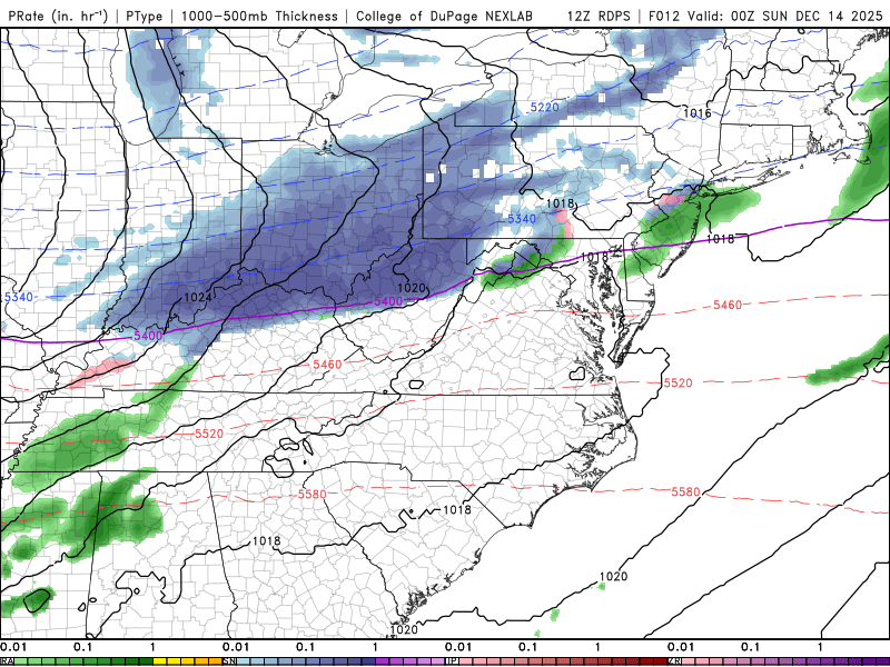
Here comes the system
-
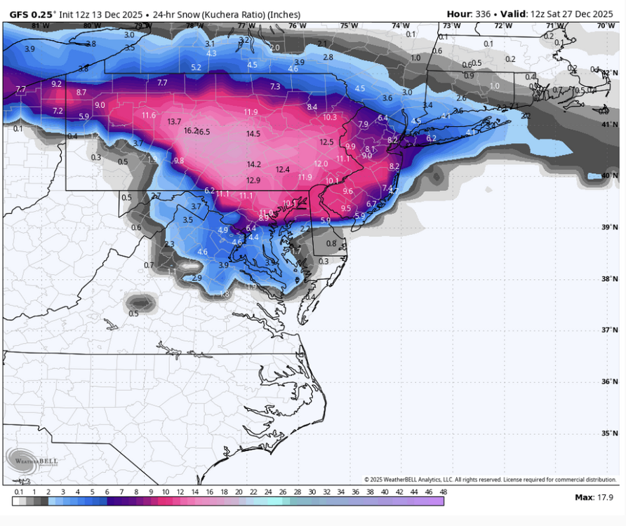
That CAN'T be right, puts a high bullseye on the Virginia high desert country....


.thumb.jpg.ad3a2e31d30aff035044689b311a0540.jpg)