All Activity
- Past hour
-
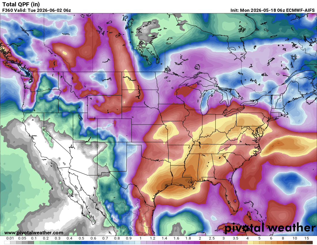
As of now, precip being focused to our west means flooding/flash flooding W of the Apps and just run of the mill above average rainfall with daily storm chances here.
-
-
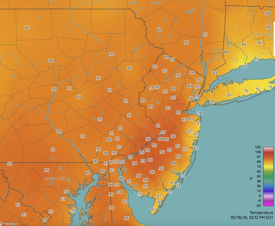
Ewr is "only" 88 on a se wind but yeah just west of there is baking
-
The backdoor cold front cooldown idea for today was a complete fail. Probably 98 or 99 for tomorrow, but yeah hitting 100 wouldn't be a surprise.
-

2026-2027 Strong/Super El Nino
forkyfork replied to Stormchaserchuck1's topic in Weather Forecasting and Discussion
my area is currently in its hottest developing nino may heat wave on record -

2026-2027 Strong/Super El Nino
A-L-E-K replied to Stormchaserchuck1's topic in Weather Forecasting and Discussion
still coping with the winter cancel -
Euro craps the bed for Wednesday's storms and looks the worst for the weekend rain, and it still has 1-2” for everyone. AI is a deluge.
-
90 here
-
Up to 94 from a forecast of 89. Is there a tripe digit in the makings tomorrow and / or wed?
-

E PA/NJ/DE Spring 2026 Obs/Discussion
PhiEaglesfan712 replied to PhiEaglesfan712's topic in Philadelphia Region
You'll be back to mid-50s weather by Saturday. It's been that type of spring. -
So precip being pushed more west....uhm, this has happened since last year. I sure hope we can all cash in.
-
Currently a 97 near TTN. Cooking over the interior of NJ today.
-
92/66 here.
-
93 currently. Pool is waiting for 5:01 haha
-
Yep 89 around here as well. Valley FTW. Dews are coming up as well. We take.
-

2026-2027 Strong/Super El Nino
michsnowfreak replied to Stormchaserchuck1's topic in Weather Forecasting and Discussion
I would never count on a "good" winter in a strong nino. But I also wouldn't just assume that the stronger the nino the worse the winter will be. There are other pieces of the puzzle besides enso. -
Cooler down this way, 82. Lawn starting to show a bit of burn.
-
2026-2027 Strong/Super El Nino
michsnowfreak replied to Stormchaserchuck1's topic in Weather Forecasting and Discussion
They dig and dig to find this stuff lol. -
89F so far at BDL. They should be able to tickle 90.
-
87.1/64 So wet , so moist, so free
-

2026 Mid-Atlantic Severe Storm General Discussion
Stormchaserchuck1 replied to Kmlwx's topic in Mid Atlantic
I just saw my first cloud!- 339 replies
-
- 1
-

-
- severe
- thunderstorms
- (and 7 more)
-

2026 Mid-Atlantic Severe Storm General Discussion
SnowenOutThere replied to Kmlwx's topic in Mid Atlantic
Thoughts on today? I listed out some of my thoughts in the Discobs thread but do we have any hope of a boundary causing forcing? -
Hmm I'm not sure it's a wet pattern right now
-
91F.. I'm usually 5-7 degrees cooler than DCA, not today.
-
Got nailed by a bowing segment at the workplace. Probably around 60 mph gusts. Power went out, generator has kicked in.