All Activity
- Past hour
-
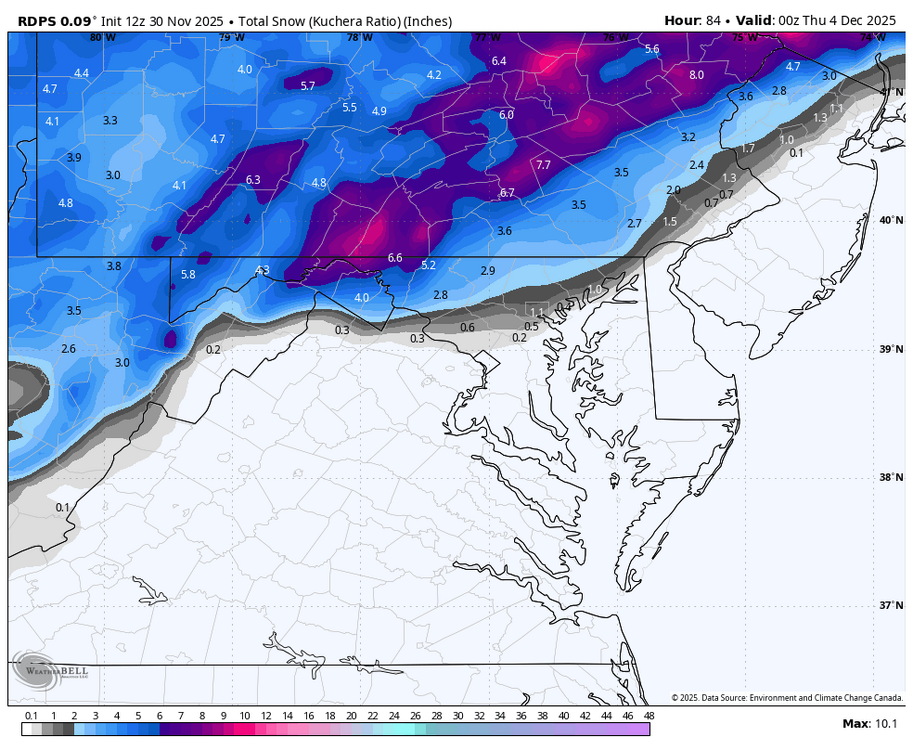
Doesn't make sense - they have 2" for Bel Air, then 43% of getting 1"+ 1" is much more realistic around here - the 12z GFS looks like ~1", less SE
-
First Winter Storm to kickoff 2025-26 Winter season
UnitedWx replied to Baroclinic Zone's topic in New England
More like Tuesday afternoon. Looks like I'll be out plowing by midnight/2am if the timing on the models holds -

First Winter Storm to kickoff 2025-26 Winter season
CoastalWx replied to Baroclinic Zone's topic in New England
It will -

First Winter Storm to kickoff 2025-26 Winter season
CoastalWx replied to Baroclinic Zone's topic in New England
Gfs looks about right to me in terms of reasonable solutions. -
E PA/NJ/DE Winter 2025-26 Obs/Discussion
KamuSnow replied to LVblizzard's topic in Philadelphia Region
-

Central PA Fall Discussions and Obs
canderson replied to ChescoWx's topic in Upstate New York/Pennsylvania
A dusting in the city -
I believe a good comparison would be December 5/6 2009. Offshore track resulting in hours of white rain. Areas just north and west had a moderate accumulation. Actually a perfect benchmark track.
-

2025-2026 Fall/Winter Mountain Thread
Maggie Valley Steve replied to Buckethead's topic in Southeastern States
GSP mentioned Winter Weather Advisory coming either later this afternoon or tomorrow morning for all of the Mountain areas including the SW Mountains for tomorrow night. Looks like snow changing to freezing rain event. They are also mentioning the next event would be Thursday night into Friday with snow likely for all areas including Asheville/Hendersonville before changing to sleet/freezing rain. The upcoming medium range continues to advertise a fast progressive pattern with moisture every day or two into next week. -
Yes you will
-
First Winter Storm to kickoff 2025-26 Winter season
dryslot replied to Baroclinic Zone's topic in New England
Its the furthest east of all guidance, I'm not sure what to make of that as i didn't follow how it has been this summer and only going on how it was last winter and it was off a bit then too. -

First Winter Storm to kickoff 2025-26 Winter season
TauntonBlizzard2013 replied to Baroclinic Zone's topic in New England
Gfs is a toaster here. Looked a bit worse than 6z -
32.4° -SN has begun
-
Is tomorrow’s system thread worthy or nah?
-
DocATL started following December 2025 General Discussion
-
Pittsburgh PA Fall 2025 Thread
Rd9108 replied to TheClimateChanger's topic in Upstate New York/Pennsylvania
Its all about the banding whether we bust high or not. Regardless "we should" see our first real snow accumulation for the season. -
Well storm starts developing in about 24hrs so pretty much should know an outcome by tonight. If models can’t get a storm right 36hrs out well then I ain’t going to waste my time on them the rest of the winter lol
-

First Winter Storm to kickoff 2025-26 Winter season
dendrite replied to Baroclinic Zone's topic in New England
I mean the euro op has to come NW at this point…right? -
First Winter Storm to kickoff 2025-26 Winter season
dryslot replied to Baroclinic Zone's topic in New England
It was more consolidated and tracked over 41/69 at 983mb. -
-
That step down process really worked for us last year.. we got nailed before the gulf coast got theirs.. oh wait
-
First Winter Storm to kickoff 2025-26 Winter season
radarman replied to Baroclinic Zone's topic in New England
That double lobe thing mostly gone, with the primary low moving NE off Delmarva and deepening. Nice looking run. -
More in line with Rgem outcome now. And more matches nws forecast.
-

First Winter Storm to kickoff 2025-26 Winter season
powderfreak replied to Baroclinic Zone's topic in New England
Pretty good consensus on somewhere in Middlesex or Worcester County, north of the mix line, is where the best chances are at a jackpot. -
Nam isn't, but Rgem is, though not as good as Gfs. Still, like I posted earlier, I would like to see the Nam and icon come for the ride.


.thumb.jpg.138963c52d552f88690c2547543b7419.jpg)
