All Activity
- Past hour
-

Overnight Wednesday, November 5, 2025 Wind Event
Baroclinic Zone replied to weatherwiz's topic in New England
Meh -
track would be a banger month or two later but should be a white rain event at best imby few models selling some LES making it's way into NE IL, riding obviously

-
 Yeah the wind woke me up, it was ripping pretty good but thankfully appeared to be just above treetop level here.
 -

November 2025 general discussions and probable topic derailings ...
Ginx snewx replied to Typhoon Tip's topic in New England
8 to 10 above 2500 nice hit -

Overnight Wednesday, November 5, 2025 Wind Event
moneypitmike replied to weatherwiz's topic in New England
Top gusts at PWM has been 38. -
-

Overnight Wednesday, November 5, 2025 Wind Event
Sey-Mour Snow replied to weatherwiz's topic in New England
Didn't even hear a gust -
There are no exaggerations involved since its stuff that has already happened. The warmer the seasons get, the more they are falling into these repeating patterns. Both the actual patterns and the model error or bias patterns. It’s a reliable feature for better long range forecasting.
-
Those enhanced trades in the CPAC are destructively interfering with MJO propagation, which is why it has really slowed down. While I believe it does propagate into phase 6, I have serious doubts as to what happens once it starts getting into phase 7…
-
WBAL still mentioning snow for early next week. Nothing accumulating but exciting all the same
-

Central PA Fall Discussions and Obs
mahantango#1 replied to ChescoWx's topic in Upstate New York/Pennsylvania
Wind was insane last night. Even though I only had a gust of 37 (because I live down in the hollow) If i'd walk up on the hill from my house I could hear those winds were much stronger. Wife was in bed when that came through and she said it sounded like there was thunder with it (probably explains why my German Shepherd was not on the porch, she went and hid). Picked up .05 rain with that too. -
 What we know when we look back.. Blend of Model gust tool was 15 MPH conservative---just not a valid-useful product for this situation. I e en checked the 19z issuance yesterday--- cant use it for this kind of CAA pattern with 35 MB difference between the departing New England low and the Central Plains high pressure system.
 -
Not bad. Im going to wait until tomorrow to really dive into this thing and see where this goes. Sent from my SM-G998U using Tapatalk
-

Overnight Wednesday, November 5, 2025 Wind Event
Torch Tiger replied to weatherwiz's topic in New England
Yeah even ack was barely gusting 55ish.. Not sure BOS/ORH peak but looked like around 50 ish. Meh -
Still out but it’s no big deal. The only thing in my fridge is some Kraft cheese and beer.
- Today
-
RR is messing with you.
-

Overnight Wednesday, November 5, 2025 Wind Event
HoarfrostHubb replied to weatherwiz's topic in New England
Halloween was much more interesting -
Was still blasting well after midnight... max gusts since 2AM this morning. Also news accounts of trees down in Queens etc. KACK: Nantucket, Nantucket Memorial Airport, MA, United States [48kt, 25m/s] KBDR: Bridgeport, CT, United States [45kt, 23m/s] KBOS: Boston, Logan Intl Arpt, MA, United States [43kt, 22m/s] KBVY: Beverly, Beverly Municipal Airport, MA, United States [42kt, 22m/s] KCQX: Chatham, Chatham Municipal Airport, MA, United States [42kt, 22m/s] KEWB: New Bedford, New Bedford Regional Airport, MA, United States [41kt, 21m/s] KEWR: Newark, Newark Intl Arpt, NJ, United States [46kt, 24m/s] KFOK: Westhampton Beach, NY, United States [43kt, 22m/s] KFRG: Farmingdale, Republic Airport, NY, United States [44kt, 23m/s] KGON: Groton/New London, CT, United States [47kt, 24m/s] KHPN: White Plains, NY, United States [41kt, 21m/s] KHWV: Shirley, Brookhaven Airport, NY, United States [43kt, 22m/s] KISP: Islip, Long Island Mac Arthur Airport, NY, United States [43kt, 22m/s] KJFK: JFK Intl Arpt, NY, United States [42kt, 22m/s] KLGA: New York, La Guardia Airport, NY, United States [47kt, 24m/s] KMDT: Harrisburg, Harrisburg Intl Arpt, PA, United States [40kt, 21m/s] KMTP: Montauk, Montauk Airport, NY, United States [41kt, 21m/s] KNHK: Patuxent River, Naval Air Stn, MD, United States [43kt, 22m/s] KOQU: N. Kingston / Quonset, RI, United States [45kt, 23m/s] KORH: Worcester, Worcester Regional Airport, MA, United States [44kt, 23m/s] KPVC: Provincetown, MA, United States [43kt, 22m/s] KPVD: Providence, RI, United States [44kt, 23m/s]
- 50 replies
-
- 1
-

-
- wind damage
- power outages
- (and 1 more)
-
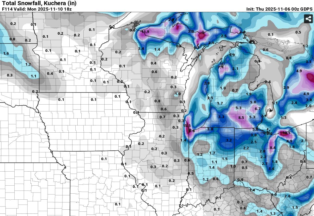
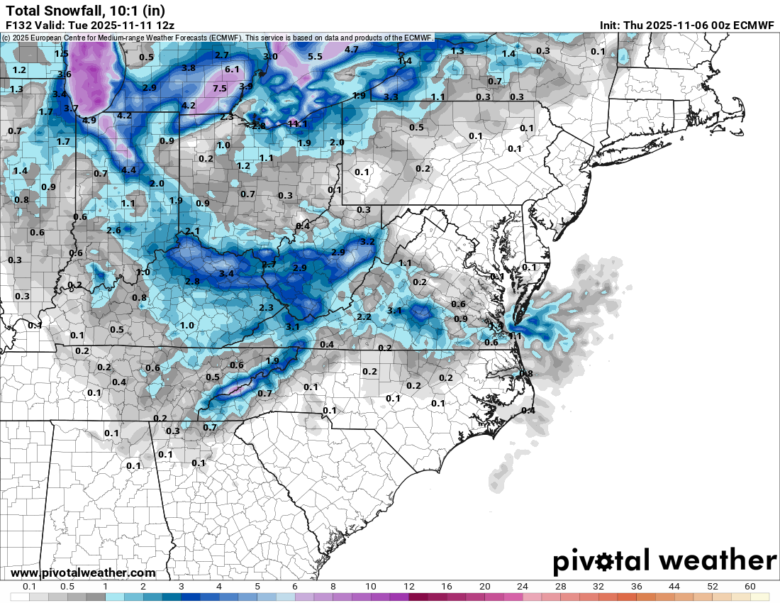
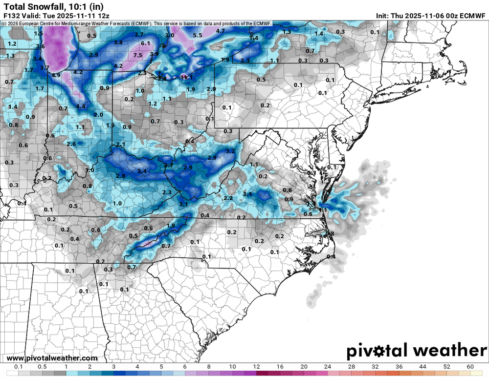
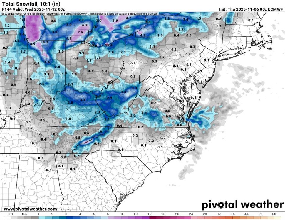
The 06z GFS is starkly different than other modeling regarding snow shower chances. We'll see which way they go over the next 48-72 hours. This may be an all winter trend, as it seems is often the case of very different outcomes being shown by it and the Euro until the last minute.
-
Not that I know of
-

Overnight Wednesday, November 5, 2025 Wind Event
Modfan2 replied to weatherwiz's topic in New England
Decent fail with the models on this one; maybe one decent gust at 2am. Hopefully DIT didn’t hit too many leaves on his morning run. -
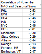
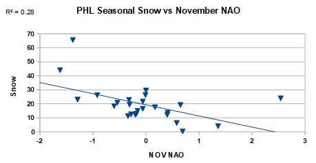
The recent flip to NAO- in modeling is positive for this winters snowfall in the northeast. Below is the correlation of November NAO with total winter snow for the La Ninas since 1950. During La Nina, there's a negative correlation of November NAO with total winter snow in the northeast; i.e, negative Nov NAO tends to produce more snow. Also included a plot for Philly to illustrate.
-

2025-2026 ENSO
donsutherland1 replied to 40/70 Benchmark's topic in Weather Forecasting and Discussion
While those weren’t La Niña winters, I expanded the very limited dataset to include all years with rapid warming of ENSO Region 3.4 from a cool December figure. The response in January and February was the same with or without those two cases. -

Central PA Fall Discussions and Obs
Voyager replied to ChescoWx's topic in Upstate New York/Pennsylvania
My peak gust was 18.9 mph just after 1:00am according to my station. -
The QBO should be at a large - number heading into Dec-February. It's rare to see it below -20 in the winter months just due to timing. We are living almost in a golden era that it's happened three times since 2015. Each was a pretty cold winter for a good portion of the forum area, or at least had a very cold section of winter. The only other times it was at -20 in January was 1959 and 1966. That said, how negative it is doesn't matter as much as it's direction. As long as it's dropping, we're good, if it's negative but rising, it's less good. We are in month 6 of it being negative. As a rule, it drops for 9-12 months in a row once it turns negative. So it should start rising between March and Juneish, meaning we should be good for winter. A lot of our notable/legendary winters were with it falling.