Search the Community
Showing results for tags 'wind damage'.
Found 7 results
-
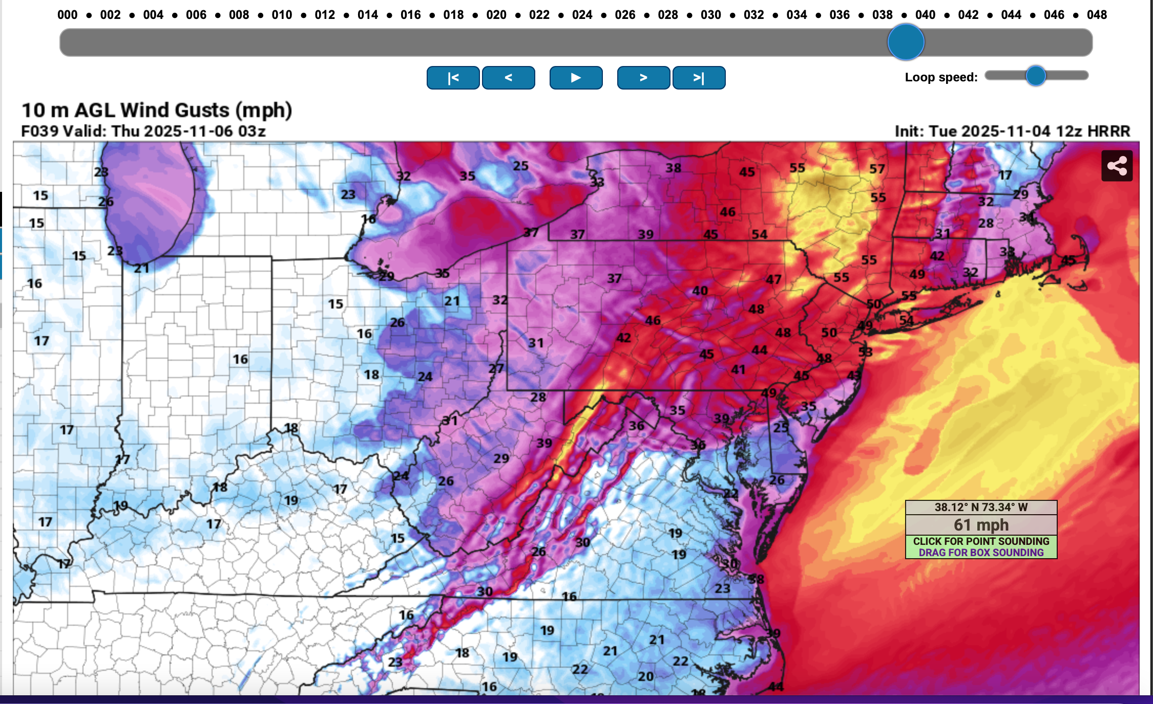
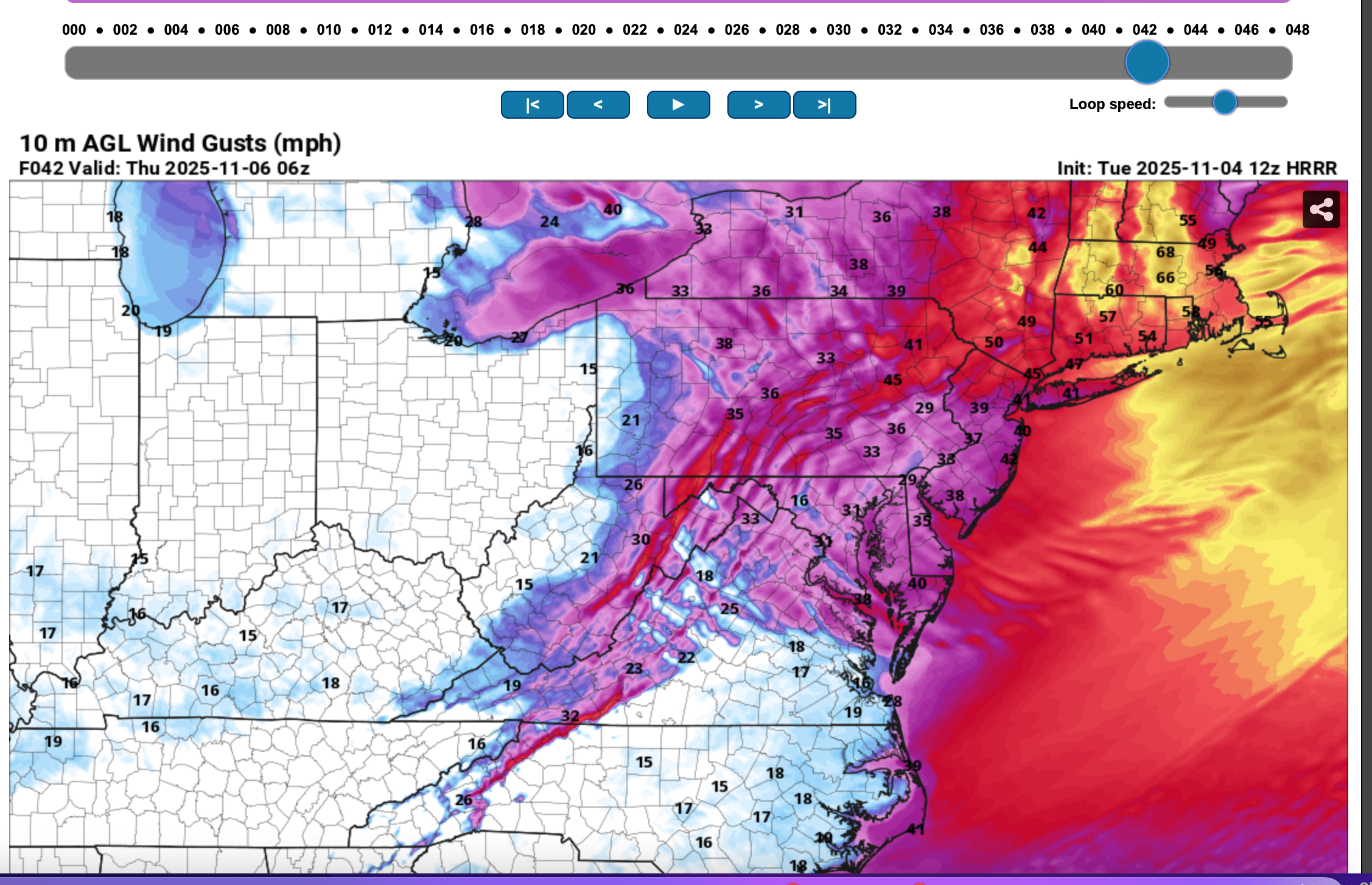
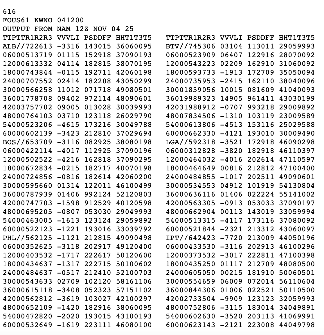
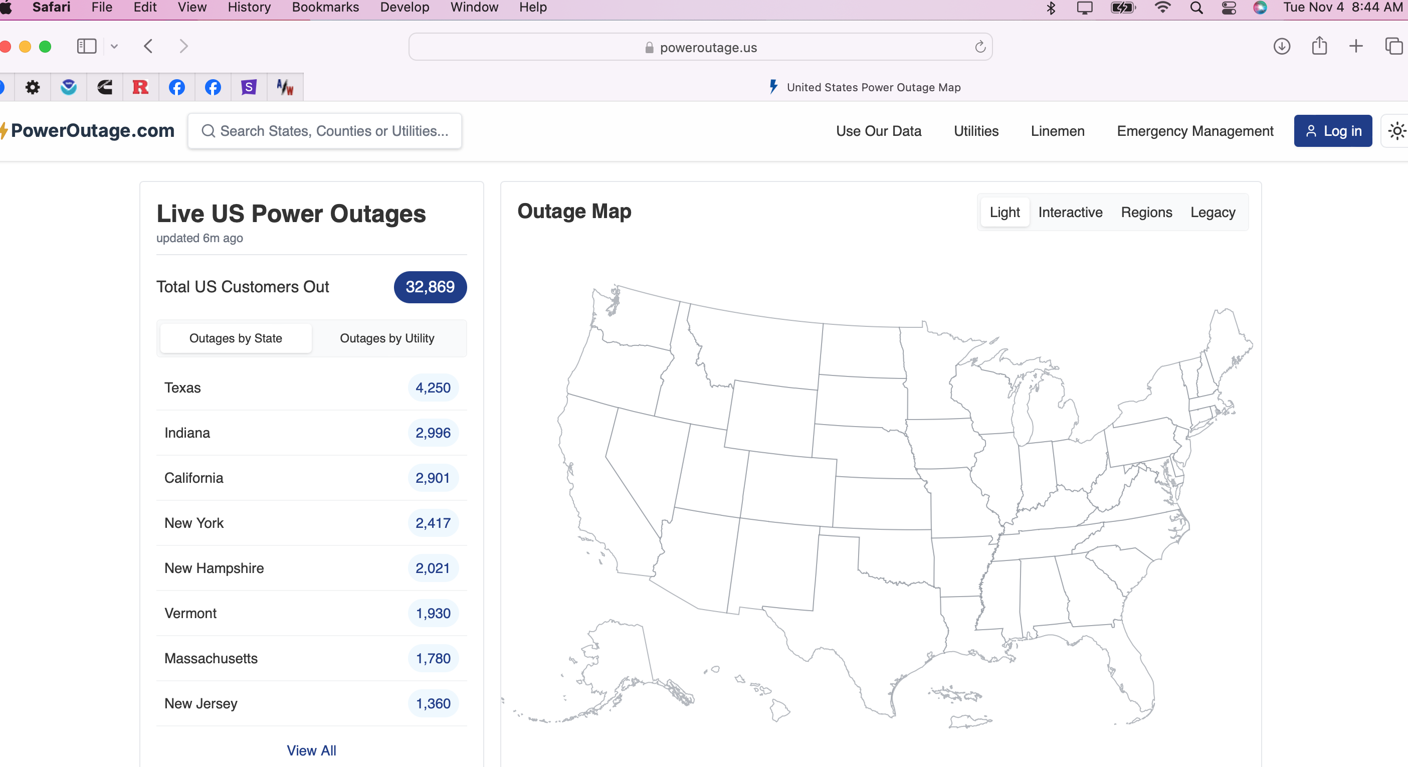
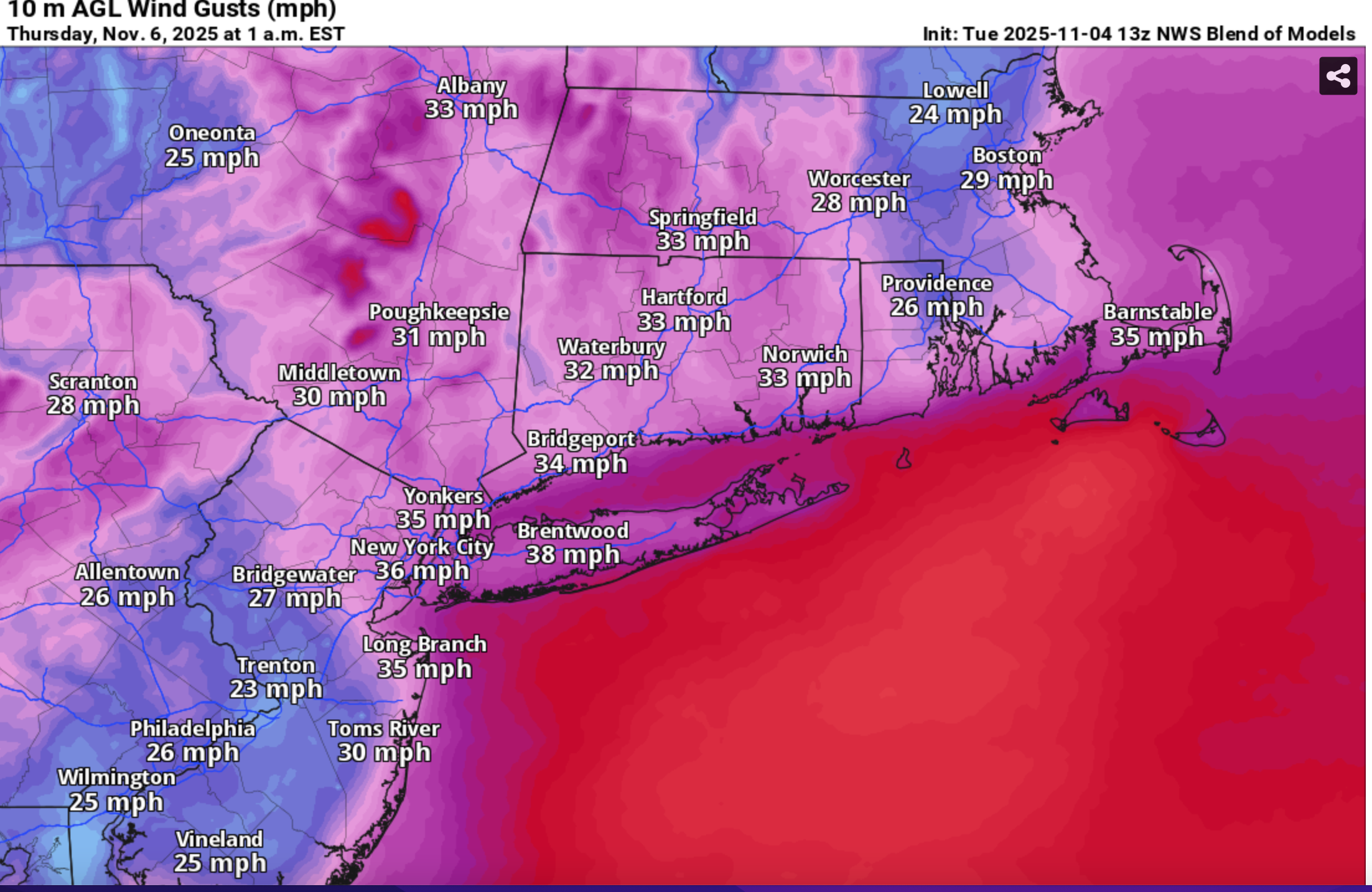
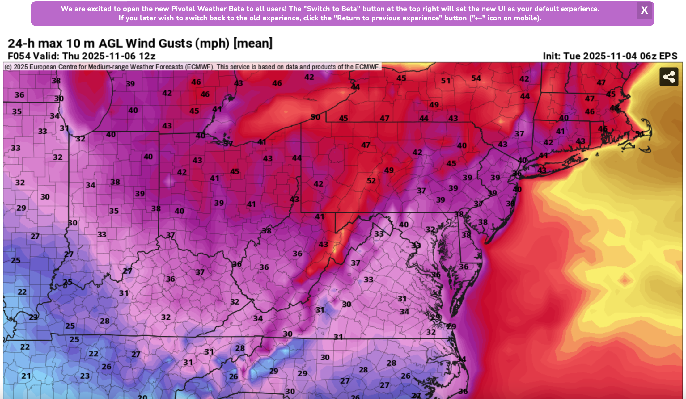
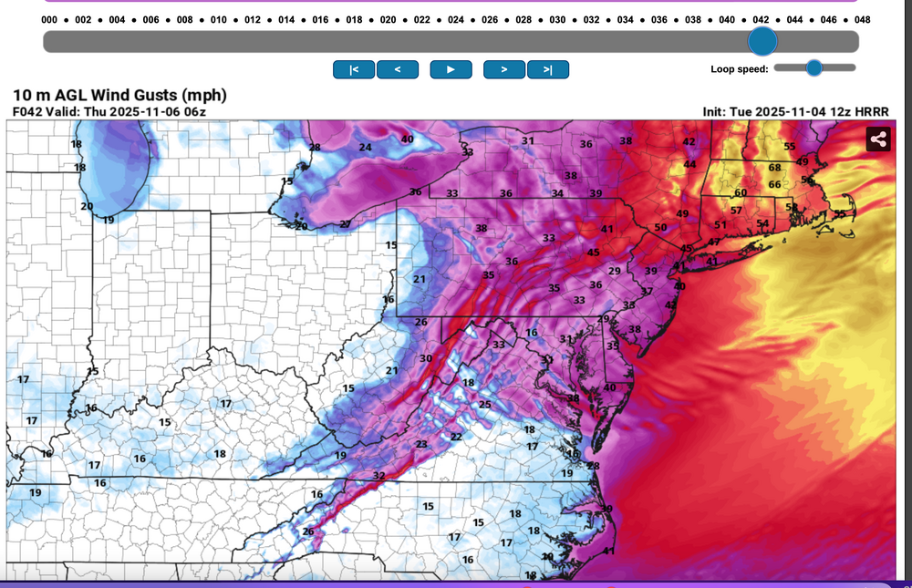
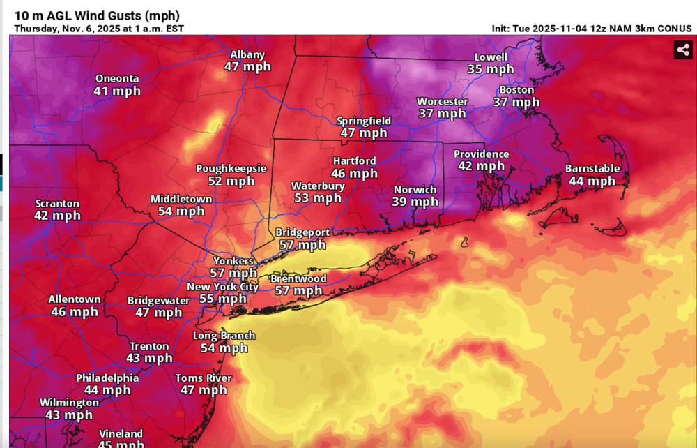
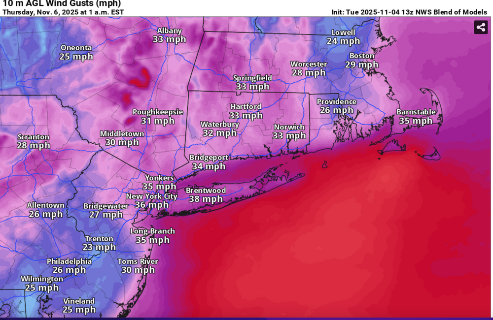
 Please follow whatever NWS OKX PHI ALY and BOX issues on the coming Wednesday night wind and tides. From our subforum standpoint have tagged wind damage for Wednesday night's brief but significant wind event associated with a 55-65KT 850 MB Cold Air Advection jet overhead. No guarantees, so the worst case 12z/4 HRRR and NAM suite max wind gusts should be 5 MPH too high but nevertheless, we should see more power outages than this morning (attached), and I expect at least a few night time -Thursday morning detours travel delays due to downed tree branches especially ridges and through NYS-CT. This will impact air travel for arrival departures Wednesday evening possibly into Thursday morning. Lapse rates look unstable for a few hours Wednesday evening up to at least 900MB, with strong subsidence drying in the wake of the Wednesday evening cold frontal passage adding to momentum transfer. A 12 hour 500MB HFC of over 150M amplifies in its east-southeast trek across NYS into New England Wednesday evening, briefly increasing the nw 850MB jet behind it to 65 kt or a bit higher. PA/NJ look to be on the southern fringe of the greatest impact which should be NYS and New England. It's an early call so no guarantees but I think its worth an eventual wind Watch or Advisory. I expect at least half the airports in the NYC metro area to hit at least 40 kt, possibly reaching 50 KT? Wind gust potential diminishes rapidly in our NYC subforum area by dawn Thursday. BLOWOUT Tide Thursday morning?: There is a chance that parts of the east facing coasts at just after midnight Thursday morning's LOW tide cycle will see a blow out tide less than -1.6' MLLW because of this brief period of wnw wind. Added HRRR max gusts at 10P/5 and 1A/6, the 12z/4 FOUS with my own personal trigger of 27KT BL wind as a threshold of wind event concerns, the 844AM today power outages with the relatively light sub 40KT gusts. Then I added the 3K NAM sampler max wind gusts, the more conservative Blend Of Models wind gust forecast and the the EPS marginal advisory wind gust modeled prediction. 1058A/4


- 68 replies
-
- 5
-

-

-
- wind damage
- power outages
- (and 1 more)
-
Follow and. further NWS updated advisory statements and possible police detours. Now that yesterdays has passed, backside wind gusts will be increasing to 40 MPH throughout the area this afternoon, with scattered or isolated gusts to 50 MPH breaking a few tree limbs and even causing rain softened ground to permit fully leaved trees to possibly topple. This would be life threatening to those unfortunately in the path of limbs breaking. Be aware of possible detours and delays this afternoon-evening. Air travel continues to be impacted, especially Noon to near midnight with certainly delays, and probably some cancels. Using the 00z/31 EPS max wind gust tool, max gusts are anticipated to be 45-50 MPH with the SPC HREF Fire MINIMUM wind gust tool offering at a minimum, near 40MPH gusts on land, except 50 MPH one the ridges and of course on the water. I do not have access to other sounding wind gust tools. 714A/31
-
Good Tuesday morning Dec 10 to everyone... I'm hoping patience works for winter snow - NYC metro. In the meantime, a fairly high impact storm is likely with potential for a squall line forming NJ coast into w CT during Wednesday afternoon contributing to downward transfer of some of the 80KT Southwest Jet. OKX already has High Wind Watch for the primary damaging wind threat area. I've added a few starter graphics-click for clarity. Includes base maps of NWS rainfall, wind gusts and also somewhat differing opinions of the Excessive rain potential from the 00z/10 guidance. One personal note of concern: Drought monitor and excessive rainfall potential don't seem to be a coherent match but I haven't checked everything regarding the monitor. 8A/10
-
Please follow all current and future NWS watches, Warnings and statements. This thread can serve as the one stop shop for both forum participant expectations and observations. Already as of Friday afternoon December 8, flood related watches have been issued for a wide area centered on the I-95 corridor with wind damage potential expected to lie east of I95, excepting possibly in isolated severe thunderstorms later Sunday. Wet snowfall accumulations could slow travel in the Poconos northeastward Midnight to Noon Monday morning. 19Z/8 December Blend of Models snowfall and and rainfall through Monday has been added to show some of the basis of the watches/concerns. Wind guidance has decreased during the past couple of days as the cold front and associated low pressure system drift across the NYC subforum late Sunday and intensifies a little slower. GEFS 18z/8 wind guidance for 50KT gusts as seen through Polar Wx is less than 40% for the eastern tip of LI. This lower wind expectation may also limit coastal flooding to more of a minor event. No matter, there is time for the models to adjust the expected results. So we have an event...not sure how serious but it will impact travel over our area. Continue monitoring the models, including ensembles and of course NWS products. 820P/8 At 851AM Monday December 11 posted review data. The wind did not work out on 50 knots gusts. The rain and snow did. So far, I've seen about 20 streams or thereabouts from southern New England to Philly to either be or forecast to go into minor flood, and one or 2 may go to moderate. Power outages were mostly NYS and ne PA where wet 31-33F snowfall exceeded 4" and wind gusts may have added to power outages. High Point NJ had 5" at 1500'. Modeling was overall good... especially the elevation dependent clarity on positive added snowfall. 19/
-
Another tropical related event is coming to much of the area as described by our IDA outlook thread participants. It may push the summer totals to near record levels, and possibly start the month of September with a months worth of rainfall in just one day, maybe even in 6 hours. Public impacts will be serious in some areas from the I-95 corridor and LI northward. Thank you for participating.
-
Snow begins in spurts this afternoon-evening NJ and ne PA and reaches NY and se NYS LI 9PM -3AM and CT 4A-8A Monday. Heaviest continuous snowfall Monday LI/NJ/nePA, but the heaviest delays til Monday afternoon-night in CT. Power outages should become numerous Monday afternoon-evening ne NJ/se NYS/southern CT and all of LI. Coastal flooding for 3 successive high tide cycles beginning late morning-midday Monday with the worst moderate to major flooding possible with the late Monday night high tide cycle. Starter graphic is the snow depth as of Sunday morning 7AM.
-
Caution: VERYYYYYYY early and this could end up much less robust than outlined below, if the northern and southern streams don't phase, or phase early enough into a closed LOW somewhere over NYS/PA/OHIO. (something always changes from what we see 7 days away but it's posted since there may be some discussion about the potential). Modeling has been trending to a large sub-1000MB sfc low early next week, with it's maximum strength in the mid Atlantic states. Ensembles to start, offer a solid 1" of rain and wind gusts 40 MPH. 12z/24 EPS/GEFS 850MB wind at 06z/1 is around 45KT, not the operational magnitude of the southerly GFS 65KT, GGEM 70KT, ECMWF 75KT, found over LI. Added the baseline D7 graphics from WPC and view these as a start. Added 12z/24 GFS lower wind field for LGA. The Richardson # preliminarily in this single 12z/24 member cycle allows downward from roughly 925MB. (50 KT). Also added the EC PWAT (tropical connection briefly 1.6"+). The 12z/24 operational EC has KI mid 30s generating lightning s of LI suggesting a High Shear Low Cape wind event. Strongest wind threat this early in the modeling is LI/CT. (did not say 50 KT gusts will occur but based only on the modeling, it's possible). A very small chance of some backside snow cover higher terrain western-northern suburbs.... To avoid disappointment on a big wet wind storm not happening, prepare for the more routine WPC scenario, BUT monitor.
- 212 replies
-
- 11
-
-
-
- wind damage
- heavy rain
- (and 1 more)