Search the Community
Showing results for tags 'coastal flooding'.
Found 14 results
-
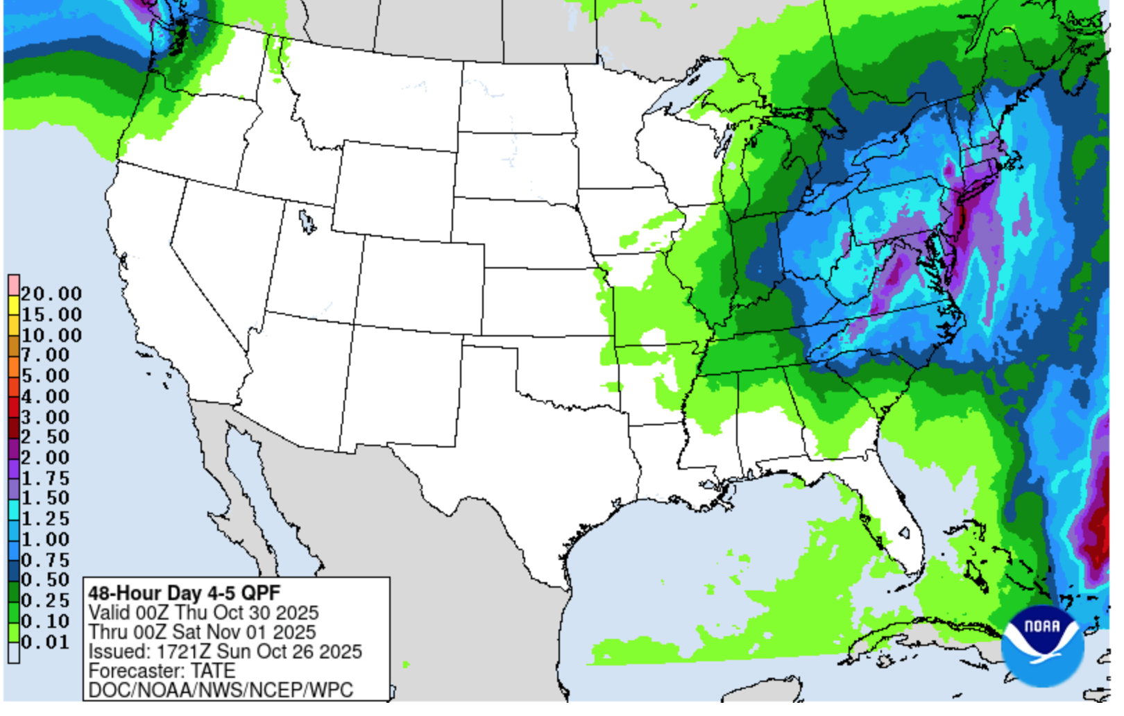
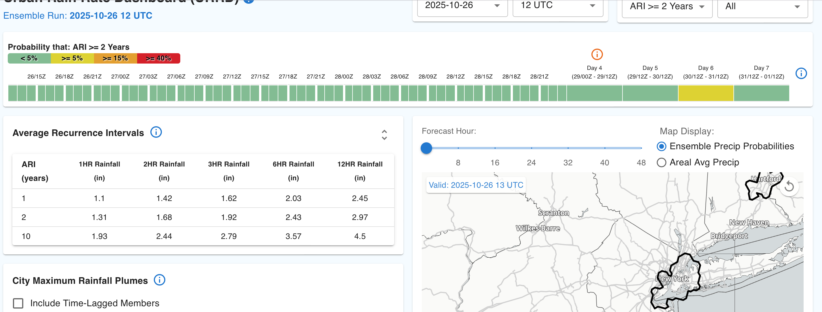
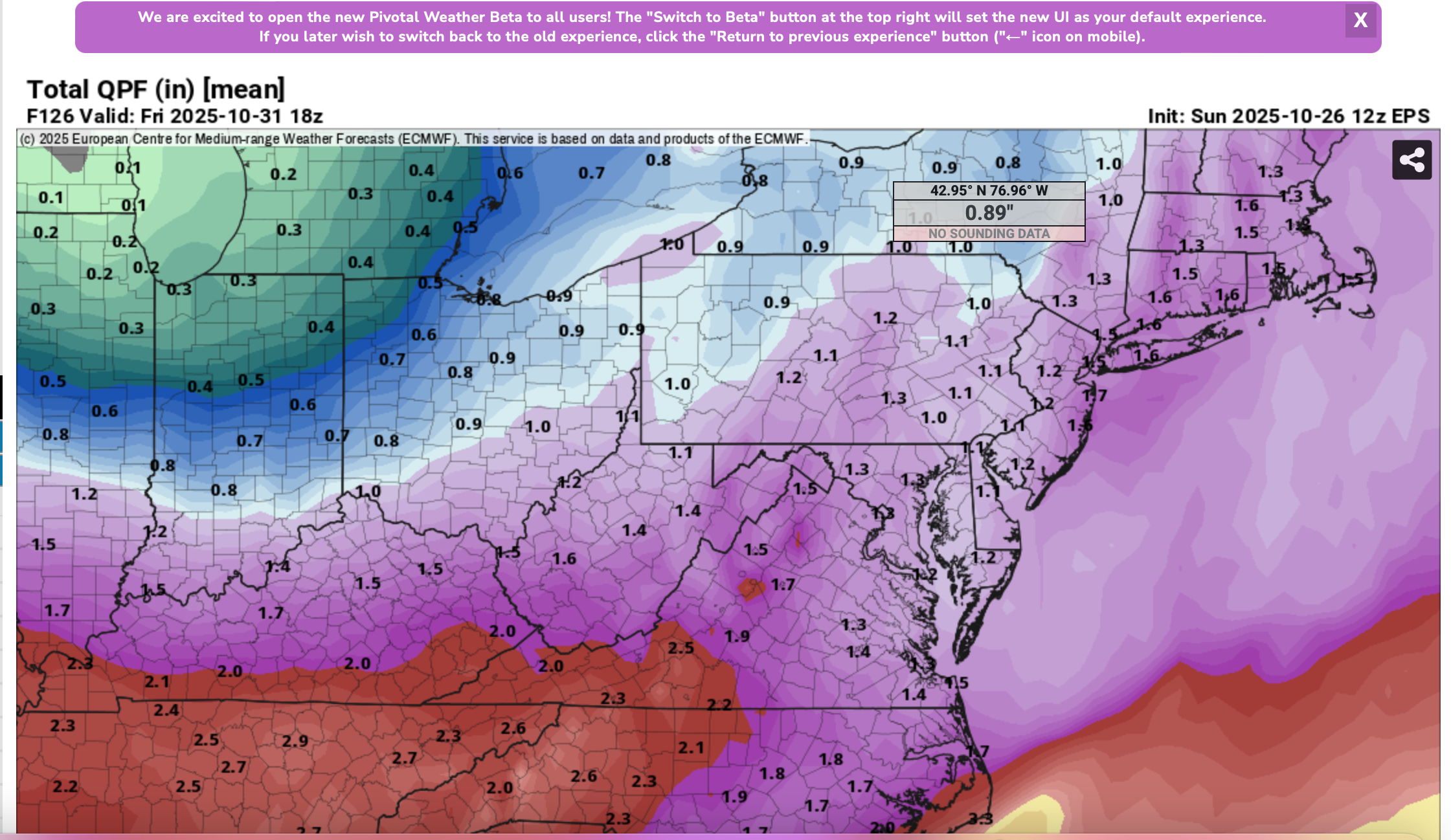
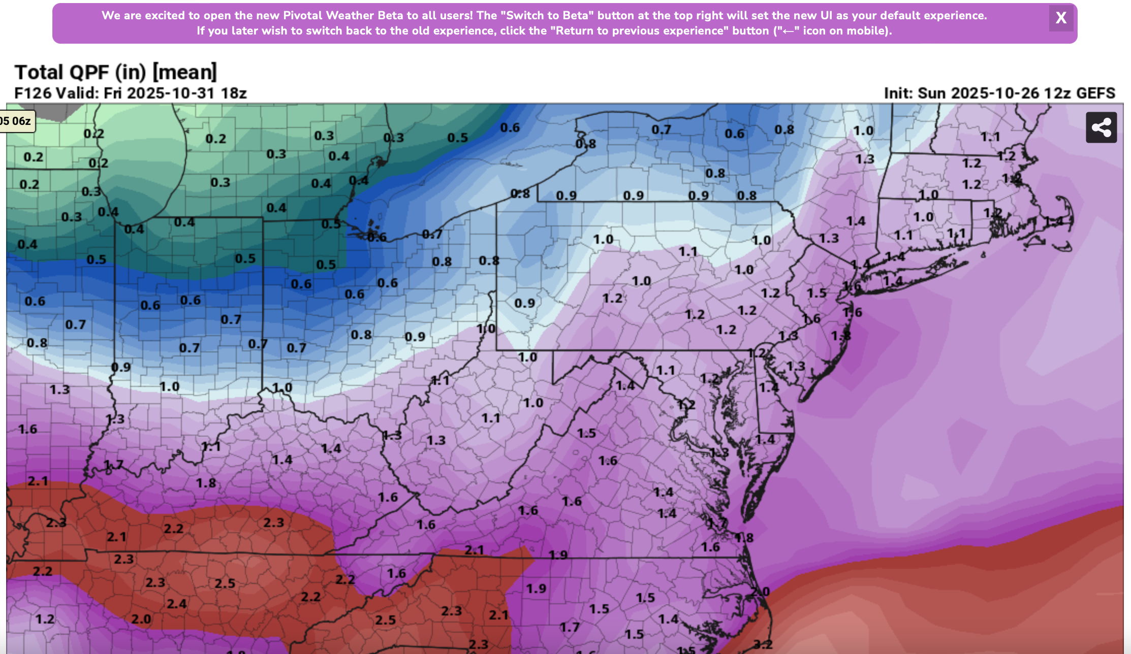
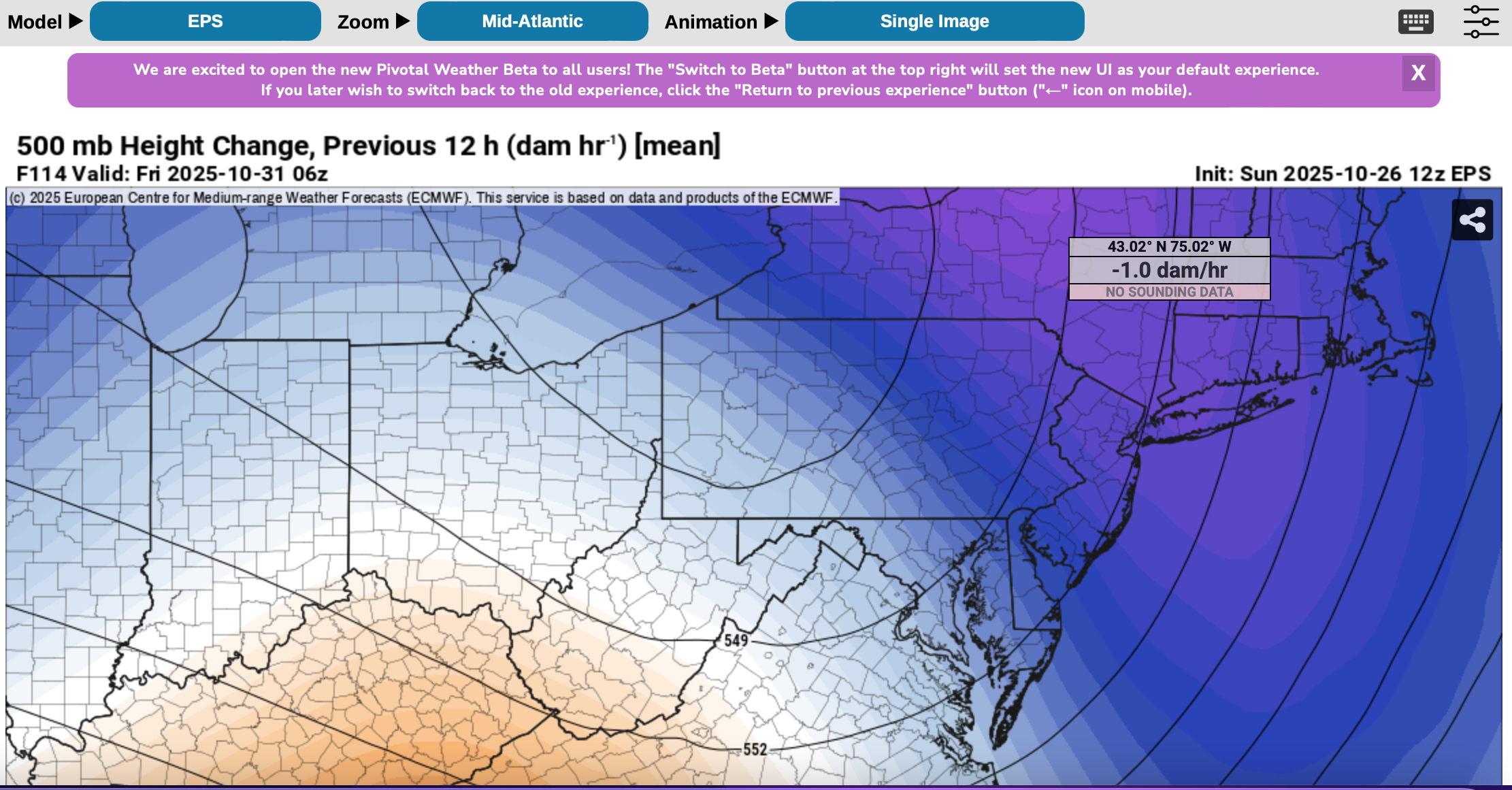
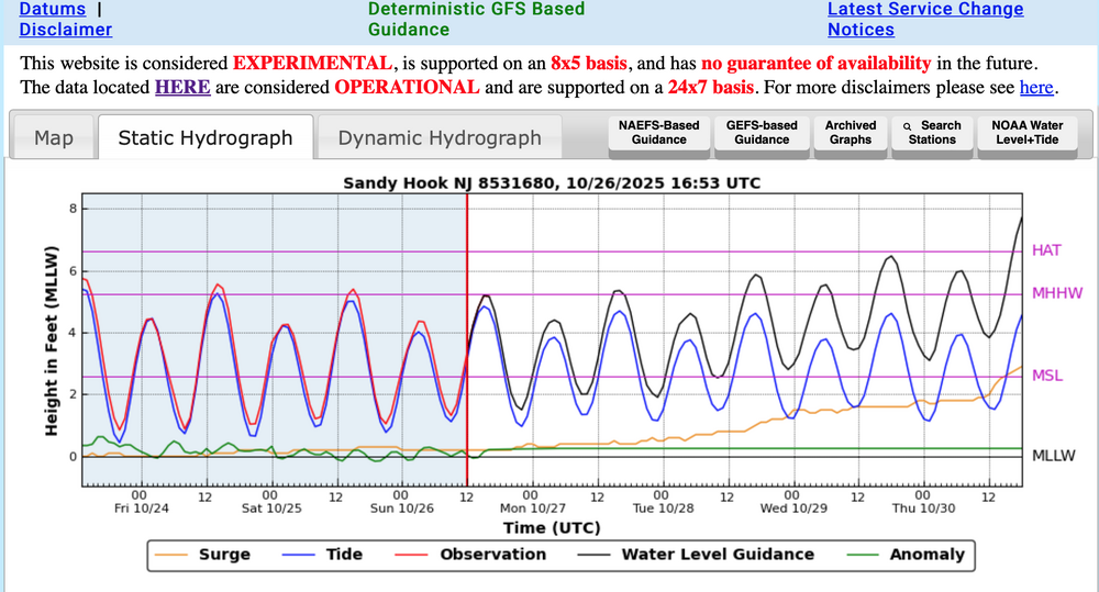
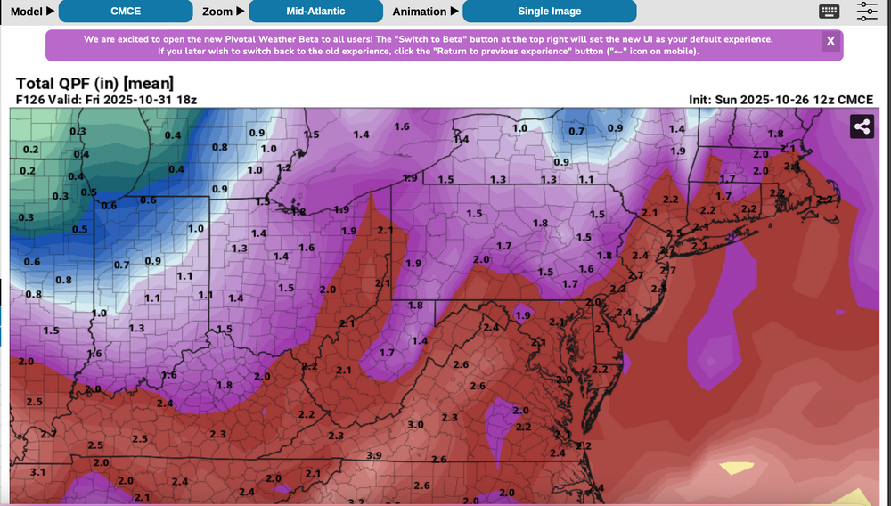
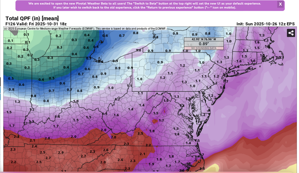
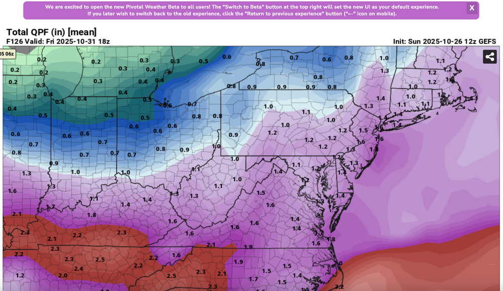
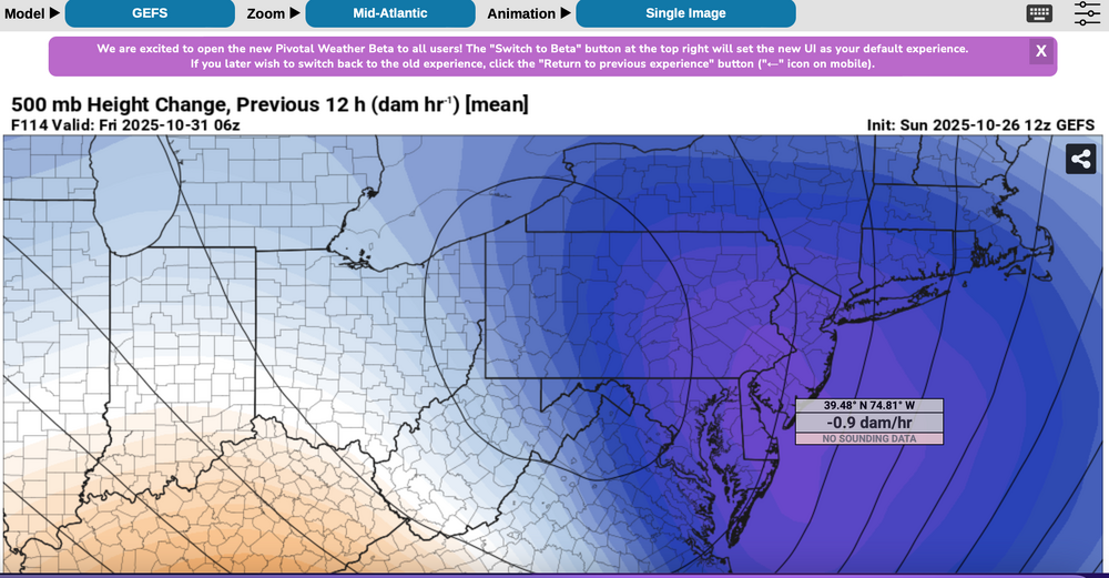
 Please follow any NWS Watches, warnings, statements that may arise from this coming minor or moderate event. This is a D4-5 advance heads-up thread for those who have a need to be advised. Modeling has plenty of spread in solutions so that the ensembles are somewhat muted. There is no doubt in my mind that some sort of minor or possibly moderate impact event is coming. Modeling has been wavering for the past 4 days and hopefully uncertainties resolve by mid week. If I had plans as a motorist or via air travel Thursday-early Friday, I'd think about delays and how to minimize adverse impact, then possibly implement changes Tuesday or Wednesday Timing of the 6-10 hour worst case is uncertain. Beneficial rainfall should result in October totals at all NWS OKX-Upton climate sites roughly 3.3-4.3", within about 1/2" of normal. Not everyone will get 1"+ but the attached Sunday afternoon 10/26 WPC guidance is a best estimate for D4-5. Rainfall still could end up less than indicated. A graphic of average return interval (ARI) for various event amounts, at NYC, is attached-not alarming. This could still end up a routine event although I think wind can add impact. Rainfall intensity during one of the rush hours combined with potential for a period of east-southeast wind gusts 45-55 mph on the remaining wet fully leaved trees may result in a scattering of broken limb caused power outages, similar to the 10/12-13 event. Lunar cycle argues for maximum worst case coastal flooding in the minor category. Modeling from P-Surge is attached. It might be too robust (follow NWS), suggesting a worst cause 3 ft surge along parts of the coasts during the Thursday afternoon-evening high tide cycle (using Sandy Hook as example). Lowered pressure this time compared to 10/12-13 contributes to the surge. Please be aware ensembles are not showing much more than 50-55knot se inflow here, limiting potential for excessive rainfall and surge. There is a slightest chance for isolated severe however CAPE seems to be very limited, despite the favorable strong shear and diffluent upper level flow. A 100-150M 12 hour 500 MB Height Fall Center circles northeastward from the southeast central USA into PA/NJ early Friday. That helps drive the relatively short duration heavy rain event. Presuming the upper Low continues to evolve northward through PA into NYS the eastern Great Lakes there should be a progressive rapid improvement sometime Friday morning. Westerly winds may gust 25-35 MPH at times during Halloween evening but hopefully without any showers in the area. Ensemble rainfall from several modeling centers has been attached as something to look back upon Saturday 11/1 when all the totals are in. The 500MB ensembles attached also show the 12 hr HFC. Fairly modest in comparison to some of the operational cycles we've been seeing the past several days. If the 5h ensemble pattern prevails or is further west, then we've tracked a routine event. The thread current headline will eventually update if moderate impact potential decreases. For now this hopefully adequately summarizes what is on the table for rain/wind/coastal concerns. Let's see if its worth tracking. 620P/26
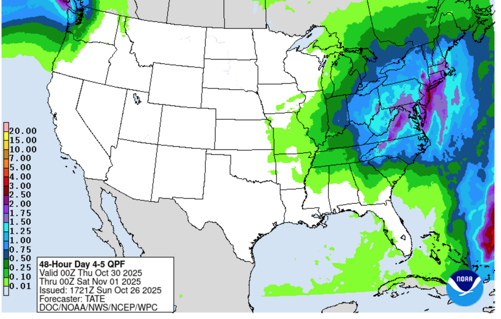


- 246 replies
-
- 12
-

-

-
- heavy rain
- damaging wind? squalls?
- (and 2 more)
-
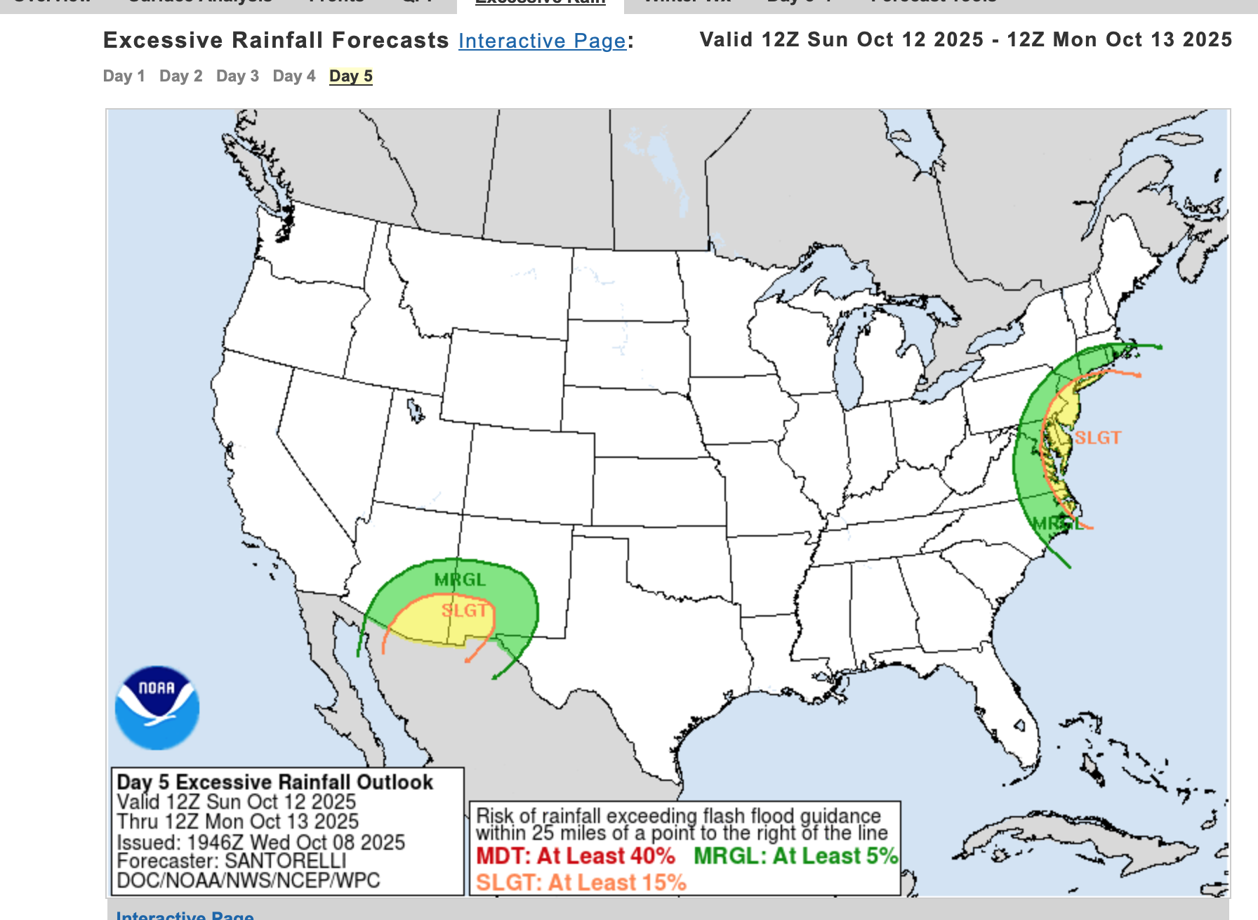
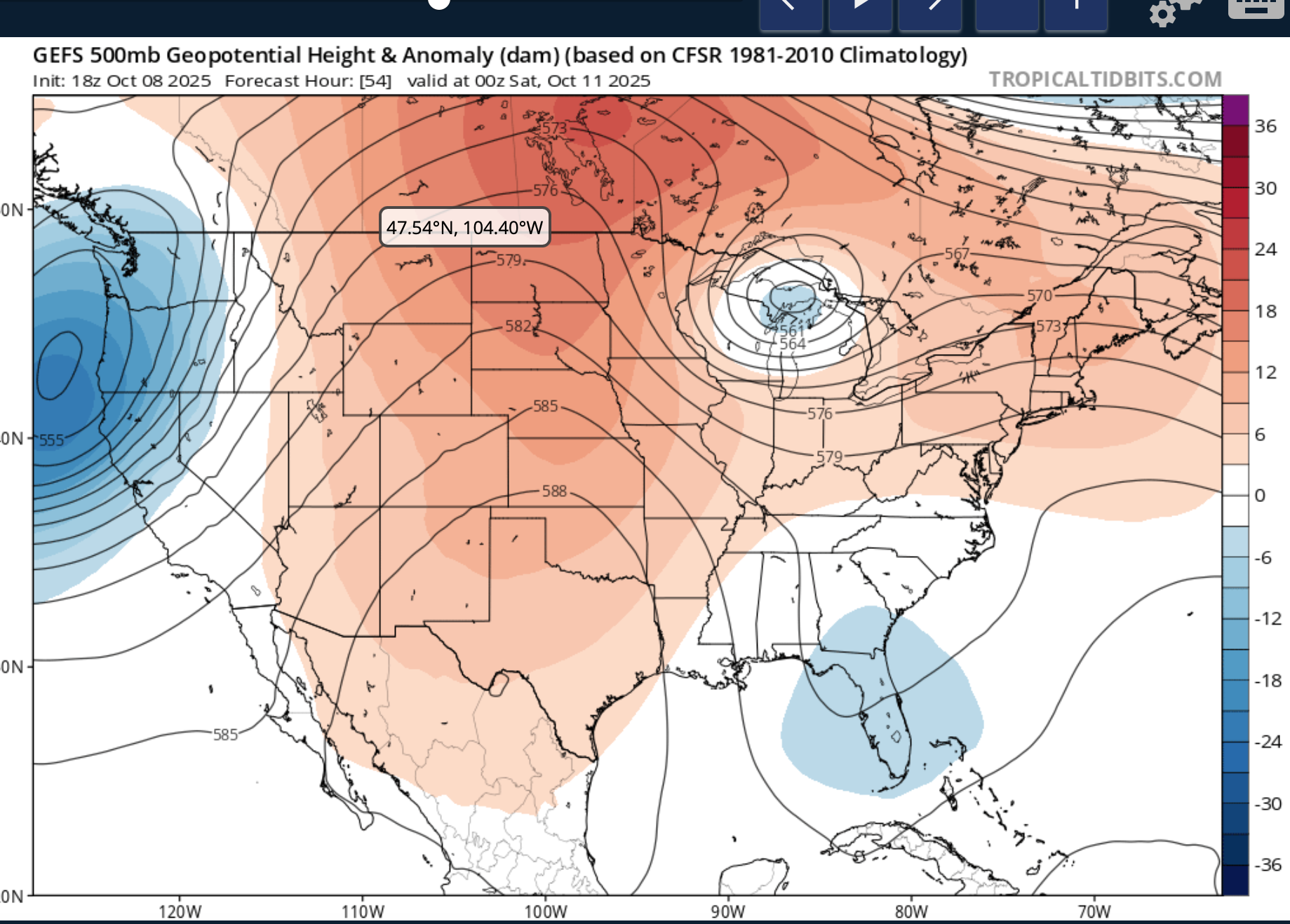
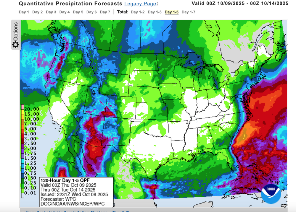
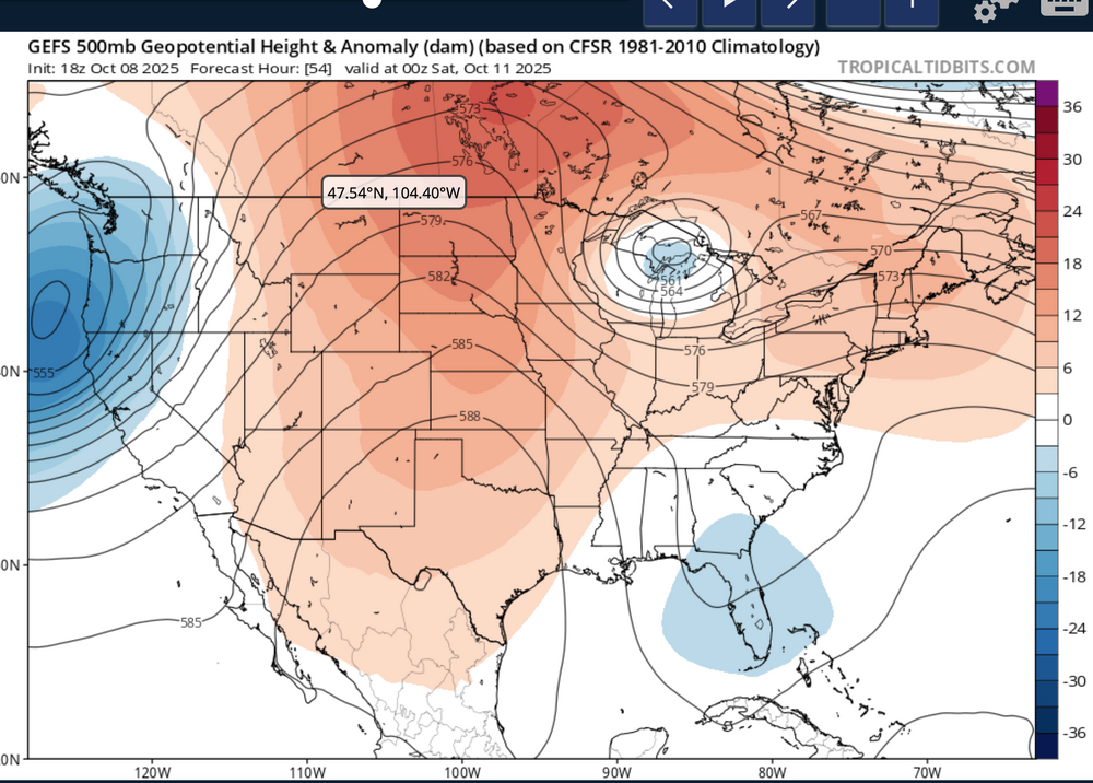
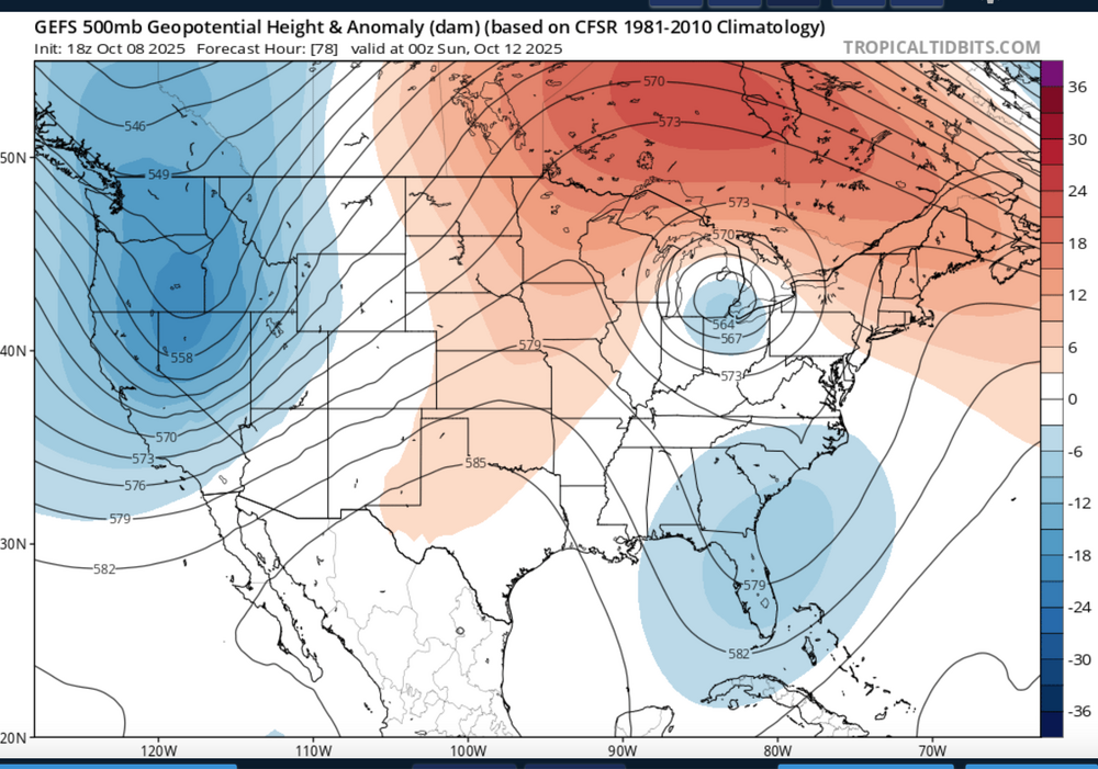
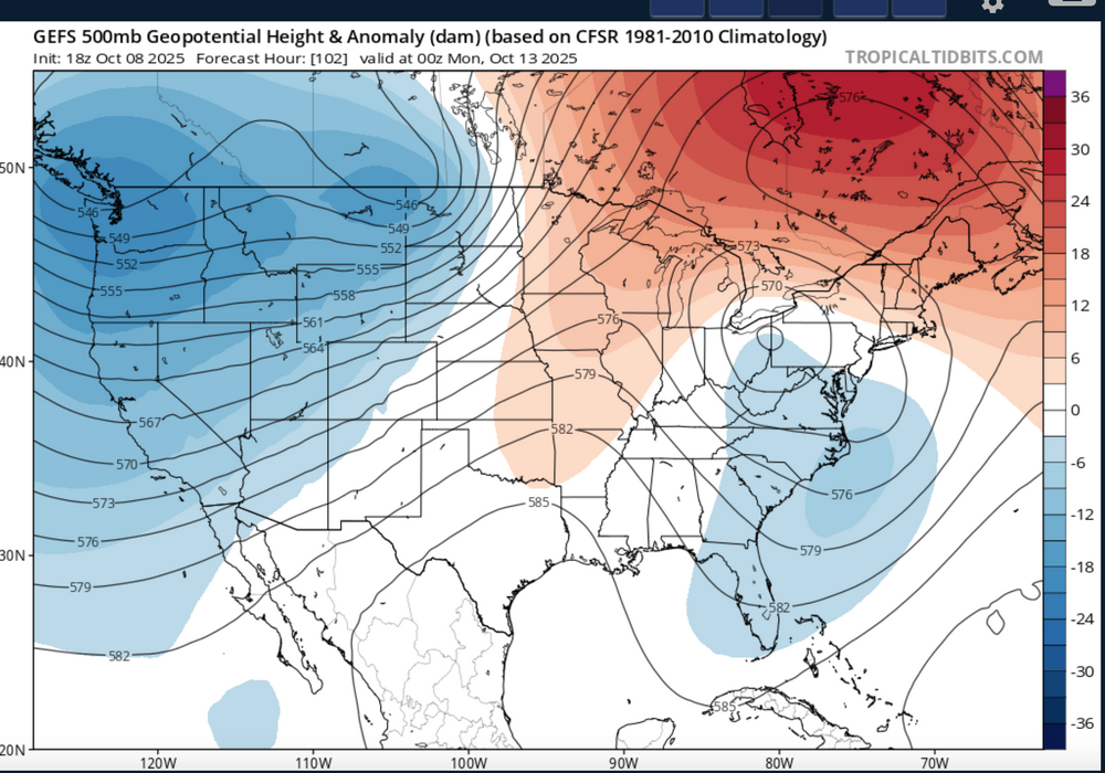
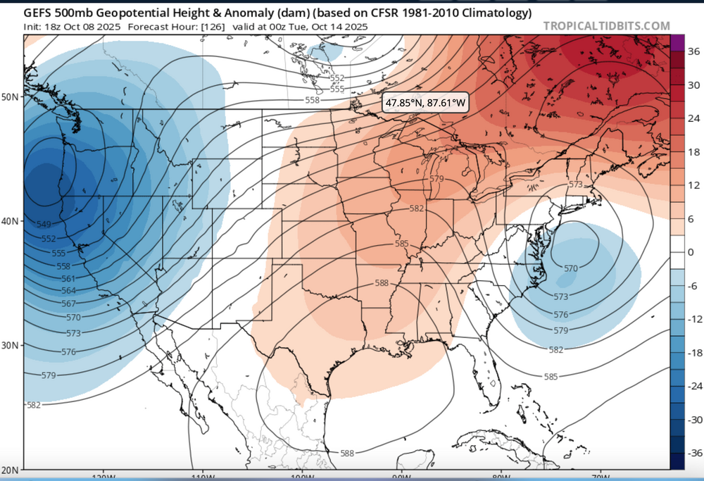
Nor'easter coming Sunday-Monday though track uncertain ranging from coastal hugger e of NJ worst case scenario to further southeast and less impact. Graphics added are the Wednesday afternoon's WPC 5 day rainfall forecast ending 00z Tue 10/14, The WPC D5 concerns for excessive rainfall issued this Wednesday afternoon - Isolated 4" in the slight risk area but general 1-2" foreseen for much of the NYC subforum between 6AM EDT Sunday and 6AM Tuesday. Also added 4 successive 24 hr forecasts of the evolving 18z/8 GEFS 5H field which I hope repeats this winter... a phaser with a southeastward diving cold core strong short wave through the Great Lakes this weekend that ingests-draws northward - the moist trough currently developing along the se USA coast and results in a fairly intense storm along the mid Atlantic coast by Sunday. The EC EPS 24 hr max wind gust tool has been cyclically consistently offering 60+ MPH in the western Atlantic and 50+ MPH along parts of the NJ-LI coasts. If this occurs, in conjunction with heavy rainfall, fully leaved tree branches would break or even uproot in some locations. No guarantees on wind strength at this time The strong chilly high pressure system that is developing into our area now will become part of a eastern Canada block and set up a strong easterly gradient over our area and should result in multiple cycles of at least minor coastal flooding with a pretty strong potential for at least one high tide cycle moderate coastal flooding (even outlier LOW PROB spotty major) for either the midday Sunday or midday Monday high tide cycle along the NJ coast. Full moon is past us so the astronomical higher tide cycles are lowering and helps reduce the chance of more than moderate coastal flooding. Still this is 4-5 days away, so intensity, track and system evolution are not locked into a worst case scenario and will ultimately determine impacts. Erosion will occur...severity unknown. It appears the ECAI has been most cyclically stable predicting this storm for our NYC subforum dating back to I think the 00z/4 cycle. Did not look at standard deviations departures of the 850 MB inflow but suffice to say, its stronger that normal. PWAT generally near 1.5" minimizes potential for much greater than 4" though the 2" PWAT axis lies just offshore. Thread headline Original thread headline below, adjusted 422 PM Saturday 10/11 "Potentially" powerful Nor'easter Sun-Mon 10/12-13/25 with needed rain-especially south of I84, and fairly high impact sct coastal gusts 50+ MPH and possibly moderate or greater coastal flooding at the midday Sun and Monday high tide cycles. posted 741PM/8

- 731 replies
-
- 9
-
-
-
- heavy rain
- damaging wind
- (and 2 more)
-
Periods of rain, some of it heavy at times is destined for most of the NYC subforum Friday-Saturday as low pressure develops off the mid Atlantic coast into a vertically deep slow moving cyclone. PW increases at times to near 1.7" in warm advection along the inverted trough Friday then the pinwheeling PWAT circles back around our area Saturday. Gusty northeast-east winds Friday morning to 35 MPH and the constancy of northeast flow this week at the time of the highest tides in Sept should yield at least minor coastal Flooding within 2 hours of high tides Friday and possibly moderate coastal flooding at the highest tide cycle Saturday or Sunday as the backwash of the offshore storm shoots some 45 MPH north-northeast winds down the NJ coast by Sunday morning. The previous 3-4 day rains are attached, and the numbers for this coming one may exceed 6" again in parts of the NYC subforum. If so, where? It's possible, despite all this projected rain, that flooding might be imited to a few small areas. Too early to be sure as of 447PM/27. The EPS has been most aggressive with this system since 9/24 cycles and the 12z/27 EPS mean rainfall is attached. These values are quite high and much higher than the GEFS 12z/27 cycle with the GEPS midway between. If it causes fresh water flooding---where? Not sure this will be very much freshwater flooding except possibly NJ/CT/urban LI. This topic should serve also for the rainfall reports. at 505PM added the tag power outages. If this rainfall develops per the more aggressive 12z/27 EPS mean, rain softened ground from this past weekend combined with new 2+" rainfall may allow spotty power outages due to tree uproots of still fully leaved trees.
- 886 replies
-
- 3
-
-
- heavy rain
- flooding potential
- (and 2 more)
-
The above hopefully encapsulates the likelihood of two upcoming significant east coast storms. Changes will occur from the some of the attached supporting graphics but we're in line for more significant weather and I'm sort of concerned about flood potential. This time maybe wet snowfall NYC.? Please consider limiting NYC snow enthusiasm with the stats attached from Don, at least until we get Jan 4-5 (if snow is still in the possibilities). It is hoped the Bluewave produced lack of 2" snowfall at CP can be put to bed, but it's possible that next Sundays probable wintry event will shift a little more inland with rain dominating along the coast. The event for the 10th could be brief snow or ice to heavy rain and snow melt, presuming we accumulate anywhere close to the attached 00z/31 EPS prob of 4" axis. Wind damage graphic via the EPS for the 10th... expectations are more of an e-ne wind (nor'easter we hope) for the 7th with gust potential 40-50 MPH along the coast and maybe minor coastal flooding (tide cycles are LOW for this storm). The event around the 10th "may" have stronger winds gusts vicinity 60MPH along the coast and a better chance of coastal flooding (tide cycles 10" higher to start). Power outages possible but impossible to predict without 24 hour confidence on wind gusts/qpf amounts/ptype/temp if and when it snows. This thread was started since I think there is general interest in snow, also flood potential for this weather interested forum. I may comment once/day but it's all yours. OBS for the 6th-7th will go in here. For whatever occurs the 10th...may have to separate out the OBS in a supplemental thread late 9th, but that's 10 days away and at least a portion of these ensemble expectations may be less than out looked through the 00z/31 cycle and therefore less impact and more routine. No guarantees here but definitely worth monitoring. Edited title 1156AM-Jan 6 to include obs and tags added obs and sleet. Edited title 645 AM Jan 8 iso include OBS for Jan 9-10 and removed the ? behind damaging wind.
- 3,610 replies
-
- 11
-
-
-
- snow
- heavy rain
- (and 5 more)
-
Another significant weather event is headed our way, about 7-8 days after the last. By the time the first day of winter officially starts, we may see a little snow or ice for the interior and substantial rainfall that could prompt flood and coastal flood statements for our area. Sunday-Thursday "potential pair" of wet events that could eventually change to ice or wet snow, especially I84 elevations Tuesday-Wednesday. Substantial rainfall is outlooked... probably at least an inch for virtually the entire NYC subforum and possibly """isolated 6"""" worst case. Not saying 6" will occur but it's in some of the advance modeling and it could end up over the fish. Persistent northeast winds for possibly up to 4-5 days could be a coastal flood problem. A disturbance in the southwest USA today-Wednesday 12/13 migrates east, ingesting short waves from the northern stream and a juicy one out of the Gulf of Mexico. Then it apparently plods northeast along the east coast. How close the upper low comes up here before fading east is with the traditional uncertainty and TBD, but it will be interesting to monitor. There could be a significant banding signal well to the northwest of the upper low and if that upper low holds together longer and eventually makes it up to the south of LI by the start of winter., it will have produced quite bit of impact here. That is still very uncertain and not a lock. Modeling seen through 06z/13: EC-EPS is basically one and done by late Tuesday, but it even flags interior snowfall, the GEFS is most robust for wintry weather and the CMCE, a slightly warmer model, also has some wintry stuff a little further north of I84. All ensembles agree on accumulations Adirondacks. This is another El Niño event, that is particularly juicy (see FL coast pressure intensity), and has a noticeable RRQ of the upper jet near the Canadian Maritimes (southern-northern stream merge) to assist upward motion. Will there be two events next week? or just one centered on Monday? Title update 6AM Saturday from the original that follows: added Damaging gusts LI/CT. A single or pair of nor'easters Noon Sun Dec 17, 2023 - Thu evening Dec 21. Potential: flooding rain I95 corridor, persistent gusty ne wind driven tidal flooding episodes next week, change to ice or snow interior elevations by Tue morning.
- 489 replies
-
- 11
-
-
-
- flooding rains
- coastal flooding
- (and 4 more)
-
Uncertainty but I think there will be substantial northeast-east isobaric gradient developing sometime in this time frame with tides starting out 1/2-3/4 foot higher than than that of current Ophelia impact. This combined with the continued daily constancy of onshore flow that began Sept 22 for NJ-DE-MD suggests to me increased beach erosion-coastal flooding """potential"""" beyond that of Ophelia Questions: If this low pressure system does form, can it muster subtropical characteristics and la-lo track of the center. Worthy of monitoring. Right now I can't grab anything from the FSU web site to check phase diagrams. I added the EPS 24 hr QPF ending Saturday morning suggesting something going on late this coming week.
-
454AM Wednesday Jan 12: title and tags adjusted to drop Saturday, focus late Sunday-Monday morning for what appears to be an 18 hour storm of snow-rain-snow. Heaviest snow tends to be modeled west of the I-95 corridor but ensembles still warrant continued concern for the axis of heavy snow including I95. At this point far too uncertain but where it snows for 12 hours, widespread 6+" seems likely. Also a 6 hour period of potential 50 kt inflow gusts is possible for the coasts Sunday morning and if it occurs with the dawn Monday high tide, would result in coastal flooding, magnitude unknown. This does not appear to be a long duration storm (24 hours+) but it should be intense for a few hours Sunday night or Monday morning. Again track uncertain, and sensitive to the intensity of the surface low. There still is opportunity that this will track too close to our area for much snow but there are several days to adjust the track and resultant precipitation type. It does appear there will be a general inch to 1.5 inches of qpf with this system, maybe thunder too. A big storm with large scale impacts entire east coast-Appalachians. The only reason I didn't highly stronger wording for impact, is that this will occur later Sunday and the following Martin Luther King Jr. Holiday. --- At this 6-7 day lead time 8PM Sunday Jan 9 issuance, options are fairly wide open. For now, a light or moderate event 'seems' likely but absolutely not a lock, nor is a heavy event excluded. This event still could be demolished to zero by what happens off New England on the 14th, or what follows between the 19th-22nd. However there already has been discussion the past several days for the coming weekend. Ending 12z/9 the past 6 cycles of the ECMWF op, the last 4 cycles of the CMC GGEM [LI 3 cycles, I84-4 cycles] have some sort of snow event, especially I84. Maybe the GFS via it's 18z/9 cycle is shifting snow emphasis on the 16th for our area instead of bombing off the coast on the 14th? Having reviewed ensembles: 12z/9 EPS/GEFS/NAEFS all have some sort of frozen event is coming to the northeast USA, along and north of I80 including LI. Have added the broad coverage low chance WPC D7 issued at 17z/9, the EPS 24 hour qpf ending 12z/17 and the 12z/EC 850 MB low (GEFS so far has nothing, still favoring the 14th but not as far south and west as previous). NAEFS products for 00z/17 are added including previous 24 hr qpf, 00z sfc temp in C, and the sfc pattern. There will be quite a few model changes-conflicts and this could end up having been a wasted effort... but it seems worthy of further scrutiny as our next possible significant snow or ice event for at least a portion of the NYC subforum.
-
Please follow National Weather Service warnings/statements. Starting from another 10 degree morning in NYC, a rapidly changing weather scenario will cause some power outages, accidents (despite a Holiday weekend) and slippery travel for a time in a fairly large portion of the forum, in part due to at least 42 consecutive hours of freezing temperatures on non snow covered ground, and beginning near sundown when the impact of solar insolation lessens. Exactly who gets how much of what is being determined by member observations with model and forecast contributions enhancing, but not hyping interest. Coastal flood threat as per OKX. Usually we like at least 12 hours of gale force onshore flow to build the water levels, but with the astronomically higher tide cycle, 980s MB pressure at Monday morning high tide, an inch of rain in the 6 hours up to high tide emptying from rivers-streams, there should be enough surge and incoming wave action to cause coastal flooding. Working a bit against the flooding NYC southward along the NJ shore is the onslaught of wind abating and turning southerly near the time of high tide. Certainly the early part of the morning high tide cycle looms larger. If you're in a tidal inundation area, follow NWS statements. I'd park my car with parking laws in mind where it can't get flooded. Wind damage: several 12z/16 HRRRX graphics are appended. Please use the legend. Midnight to 6AM is best chance for damaging wind , to occur in a 3hour period ranging from near 2A NYC to near 5A e LI. Gusts to 60 kt possible e LI with gusts 45 kt possible NYC metro airports. I could be too conservative. Have cell phones charged and be prepared for no internet early Monday. Many of our members, even to western LI will be reporting a bit of snow or sleet late today (some are from Ocean Effect already). mPing will be helpful especially for us inland folks just north of I78 where an hour or 2 error in the precip phase change from snow to sleet/freezing rain or rain can mean an inch or two of snow. The 12z HRRR, HRRRX, and 3K NAM seem to support slightly more snow than maybe some are anticipating. Whether that occurs is unknown. No matter, if you have heart problems and live north of I80, you may want some assistance removing slush laden with maybe 3/4" of rain (glop). And of course have your resources to clear it by 6PM Monday when temperatures falling below freezing start the solidifying process. {The HRRRX amounts may be too large by 2", so it is a slower to change model with 1/4-1/2" everywhere up through I84 by 06z, so that could bias the amounts high there. edited in at 1036AM} ICE: I think parts of the I84 corridor including Sussex County NJ may have pockets of damaging ice near 4AM Monday when the ice combined with wind gusts 45 MPH in the ridges could be enough to knock out some power. Monday afternoon-evening: The trough aloft passage and influx of colder air should wring out areas of 0.1-1" snowfall in the steep moist lapse rates associated with the cold pool aloft, including NYC-LI.
-
637AM Sunday: : headline updated to Major near blizzard and added power outages. Major near blizzard Nor'easter coming. I would not plan on driving anywhere on Monday in northern NJ, ne PA, se NYS and ditto CT Monday afternoon-night, MA Monday night. NYC my guess is a foot, possibly more before mixed Monday night. Otherwise, amounts between 1-2 feet from I78 northward with lesser 8-18 inches CT and MA where rain/sleet invades later Monday night. Isolated 30" possible nw NJ, or ne PA into the Catskills by the time this storm ends early Wednesday.. Drifts 3-4 feet. Power outages possible Monday afternoon and night from northern NJ northeastward to CT and Boston from a combination of heavy wetter (heart attack for the hear tcondition vulnerable) snow and northeast wind gusts of 40-55 MPH. Snow starts central NJ around 3 PM, northern NJ-ne PA 6-10P, CT around dawn Monday. Worst of the storm NJ/PA sunrise Monday-midnight Monday night, CT Monday afternoon-night. Coastal flooding may be major near the midnight Monday high tide cycle? Follow NWS. ---- 615AM Saturday: Imperfect probably messy big snowstorm is coming, imperfect in that modeling the past 24 hours is drifting north and suggesting a dry slot late Monday will allow enough warming for sleet (rain LI) to I80 including all of I95 Monday night so that the stratiform burst of 1-2"/hr Heavy snow during Monday, especially afternoon, becomes bands of snow in the interior late Monday night-Tuesday, some areas probably recovering Tuesday with several hours of no precip. So, my own single forecaster point of failure but use of ensembles could be too pessimistic about the sleet/rain intrusion. For NYC... I'll start with 6" with possibly as much 1/2" late 31. Hope that its mostly snow after 00z/2 but even if, snow ratios may be down to 7 or 8 to 1?? I dont' want to cap NYC since am uncertain about dry slot. Sleet/rain/freezing rain may be getting involved Philly to Toms River during Monday morning. There may be a period of near blizzard conditions on LI centered Monday afternoon? BUT, I don't want to call it a blizzard for fear of easily missing criteria. The point of this paragraph, is that I think Monday, especially afternoon should be the worst period of travel and if models continue this, in future cycles through Sunday morning, then I think it would be a recommended no travel for that 6-12 hour period to limit accidents and allow plows to maintain passable-less slippery conditions for first responders. Snow may be wet on LI/Monmouth-northern Ocean Counties in NJ if 6" at 32-33F, we would have power outages... still too early to be sure. CT I84... continue to notice some multimodeled lesser snowfall there, so while I think a big snow there, cautioning myself. Coastal flooding: see NWS statements/flood watches already posted and no change from yesterday with the late Monday evening high tide cycle most favored for flooding (within 2 hours either side of the time of high tide) Graphics are the 00z/30 EPS as a base amount, the 00z/30 EC IR prediction for 06z/Tue showing the dry slot penetration, and the NWS 09z/30 prob for 6" or more of snow by 12z Tues. That's the reasoning basis for this update.
- 2,426 replies
-
- 4
-
-
-
- heavy snow
- ice pellets
- (and 3 more)
-
504AM update on Friday (24 hours after initial issuance). Withdrew from the title INDIRECT. --- 333PM Friday about 33 hours after issuance. Changed title to Moderate - MAJOR impacts, tags changed from tropical weather to hurricane gusts, heavy rain changed to flooding rains, RC and CF remain as they were It is becoming more apparent via modeling through the 12z/20 cycle, tho follow NHC, that this storm wants to turn northwest and make landfall anywhere between Block Island to Sandy Hook. Where and intensity? IFFFF Henri still passes east of Montauk, that will be fortunate for LI/CT. Follow NHC, and updated collaborated models and experienced statistical output of Tropical verification. Strongest gusts and largest waves & storm surge should be east of the center on the Atlantic side of the the storm, but beware all the east and northeast facing inlets LI Sound. RC obviously dangerous, and possibly even for experienced surfers. SHOULD BE ZERO casualties due to RC and high Surf. There is enough info out there now that asks us be smart about living safely. Wind: potential from a combination of squall gusts 40 (to possibly ~ 65kt) and preceding heavy rains near and east of the center track, to uproot and snap fully leaved trees, with 'potential' for long duration power outages. Therefore east of the center track, charge your phones, have fuel ready for generators (outdoor exhaust only) and maybe rent a couple of movies since along and east of the center internet connectivity may be lost. TOR (s): maybe? mainly northeast quad of Henri Sunday morning. Rainfall: Looks like 3" near and west of the center of passage, but pockets of surprise amounts elsewhere in the interior? Max by Tuesday in the lingering weakened remnant state??? Maybe isolated 10" somewhere??? Coastal Flooding: dependent on timing with the high of the tide cycles this weekend. This will be a pretty big storm, with varying impacts. Worthy of monitoring updates and being cautious about outdoor activity late Saturday-Sunday. ---- Below from Thursday 5AMish 8/19/21 Follow NHC and NWS collaborated guidance on the path and impacts of Henri upon our NYC subforum. Astronomiically higher than normal tides combined with some onshore flow and building seas should result in pockets of significant coastal coastal flooding this weekend. Presuming the direct path of Henri remains e of LI, we are probably spared a tide cycle of major coastal flooding. Vulnerable regions to typical minor coastal flooding should monitor NWS statements for an event that may be larger than the typical minor events encountered through the year Rip Current: Appears to me difficult to avoid the risk of dangerous rip currents this weekend. What might be good for surfers as exposed Atlantic shores coastal waves build to 6 feet, will be life threatening for most, if not all swimmers. Follow NWS and local official guidance including that of life guards. Heavy rain: The combination of a trough(s) extending northwest of Henri and PWAT nearing 2" again, may develop pockets of intense slow moving showers well northwest of Henri's passage. There could be isolated 3" amounts in our NYC subforum. Henri winds: 34 KT gusts probably remain east of our subforum but follow NHC guidance. 19/457AM
- 1,603 replies
-
- 1
-
-
- hurricane gusts
- flooding rains
- (and 2 more)
-
Snow begins in spurts this afternoon-evening NJ and ne PA and reaches NY and se NYS LI 9PM -3AM and CT 4A-8A Monday. Heaviest continuous snowfall Monday LI/NJ/nePA, but the heaviest delays til Monday afternoon-night in CT. Power outages should become numerous Monday afternoon-evening ne NJ/se NYS/southern CT and all of LI. Coastal flooding for 3 successive high tide cycles beginning late morning-midday Monday with the worst moderate to major flooding possible with the late Monday night high tide cycle. Starter graphic is the snow depth as of Sunday morning 7AM.
-
Good Wednesday morning everyone, I've followed a recent example on the New England forum and offer this topic as a start over at 1PM with obs-nowcasts. The tags included hopefully cover the gamut of potential amounts. If we are certain about daily records being exceeded please add and ditto if we get top 20 at any xmacis climate site. Thank you all for contributing to the excitement-anticipation of a pretty good nor'easter.
- 1,011 replies
-
- 3
-
-
- heavy snow
- sleet
- (and 4 more)
-
Edit topic: 525A Wednesday 12/16: No change in thinking including uncertainties along I95. I just cannot shake the basics: S+ axis is usually 90 miles left of the 850 low and the northern half of the 700MB low and the deformation zone near 500 MB with contribution from the nose of the 850MB 50-65 kt easterly jet (moisture transport). This favors I84 and banding casts northwest to a central PA - east central NY area (roughly IPT-ALB) where 20-25" seem probable within 60 miles of that axis - at least in the high terrain, but must consider mountain shadow lesser amounts in the leeward valleys. There a multiple models showing that axis. In our forum, I think most everyone will see a period of sleet near or after midnight and that the bulk of the snow occurs in a 6-10 hour period prior ~ midnight, but that there will be a tail of moderate to heavy snow toward dawn with still 1-4" after sunrise Thursday on top of whatever occurs before sunrise---the heavier 4" potential ne PA, extreme nw NJ, se NYS and CT {where 5" may occur in 2-3 hours after sunrise Thursday}. Drifts to 4 feet possible ne PA, se NYS and northern CT where 18" accumulates since winds will gust 30-40 Mph at times overnight. NYC CP still 6-10" in my mind but shakey and may be too high because of only 10-1 snow ratios at best, sleet and possibly rain compacting as well as temps near 33F at times during the night. The power outage concerns continue near I95 with 45-50 MPH gusts (9P-6A). Coastal flooding - please see NWS offices for minor or moderate near the time of high tide Thursday morning. Finally, even if it rains or is above freezing w LI and Monmouth/northern Ocean County NJ tonight--- there could be sudden icing near sunrise Thursday when the wind switches from northeast to north and drops temps 5-10F in an hour, and iceing the residue and make travel very hazardous again in leftover new snowfall. Otherwise temps in the I84 corridor ~20-25F throughout the event. Will add some graphics by 6AM on wherever the last page of the thread. NOT a top 20 for NYC...best chance is MPO-POU axis in our forum. This is my last topic update for this event. Edit Topic: 445 AM Tuesday 12/15: NO change in thinking. Except for the outlier south GFS/GEFS, all systems appear go for a major snowstorm as outlined below in the 6AM Monday topic update. Will detail in the latest page by 545AM. 00z/15 EC/NAM/RGEM/UKMET/GGEM/UKMET operationals on board! There will be multiple (~12 graphics of supporting model documentation-most probabilistic and 2 day top 20 snowfalls in the available period of record). --- Edit Topic headline at 6AM Monday 12/14/20. Please monitor NWS Watch-Warnings for this storm and associated statements and still uncertainty on where highest impact. There is/was some overall slight southward shift in the guidance in the past 24 hours and so my uncertainty for the forum is northern CT-Catskills, and LI/I95 southeastward. WPC still has 1.5"+ qpf just s of I80-LI and 3/4" into northern CT. If you have travel plans Wednesday into Thursday I95 northwestward from VA through WV, PA, NJ, NYS and southern New England it's probably a good idea to consider changes, based on your NWS or other favorite media outlet forecasts. I think this will be a top 20 snow storm for a few parts of our NYC subforum (basically ~ 1 foot will prompt that review) but unsure where. For now between I95 to I84. Anticipating (not guaranteed) widespread closures or delays for all transportation systems I95 corridor northwestward Wednesday evening into Thursday morning,. For those who have access and wish to do so, you can calculate an experimental storm index to get an idea of what is probably coming. I don't want to presume more than Major yet (crippling is the next step up). Here is some information. https://www.ncdc.noaa.gov/snow-and-ice/rsi/?nesis Still variability in northward extent of heavy 1 foot snow ranging from the NAM Adirondacks to the GFS-RGEM I80-LI. UKMET is still quite far north. Ensembled r/s line looks to remain mostly south of I80-LI but awfully close, close enough to think sleet, rain or freezing rain mixes in for a time after the initial Wednesday evening thump for LI and s of I80. EPS continues almost unyielding on the widespread 8-18" snowstorm (isolated 2 feet possible in the banding somewhere north of I80-LI). Major power outages possible wherever the 6" of 32-33F wet snow accumulates along with wind gusts of 40-50 MPH. If this were to occur, it would most likely develop between 9 PM and midnight Wednesday evening per consistent modeling of snow onslaught and wind gusts increasing past 30 MPH. Am targeting LI south coast and NJ coast but this will require 6" wet snow (32-33f). Isolated wind gusts above 50 MPH possible on those coasts. Snowfall rates of 1-3"/hr possible in northward transiting bands Wednesday-evening/ night. Where these tend to park on the northern extent of the storm, will probably be the 2 feet of snow, especially with ratios drier than 10 to 1 (maybe 13 to 1). NWS has the multi model ratio blend tool and BUFKIT can assist for those who have that tool. There could be closing bands of moderate snowfall Thursday morning after sunrise into early afternoon as the comma head tends to fold southeastward behind the eastnortheastward departing storm. Clearing the first few inches of snow around 8-10PM Wednesday will make it easier to remove the additional snow Thursday morning. Where it's wet-caution for those with heart conditions., This strong easterly surface gradient (northeast wind) between the cold 1035MB high over Quebec and and the probable 995-1000MB low near Cape May early Thursday will produce minor to moderate coastal flooding, for the Thursday morning high tide cycle. Follow NWS statements. No graphics update with this topic edit. --- Edit Topic time at 506AM Sunday... otherwise an 18-24 hour nor'easter coming with the uncertainties continuing as previously listed below. HIGH impact late Wednesday afternoon into Thursday morning with many cancellations probable of whatever activities in this Pandemic. It's 5-6 days away but taking my cue from our participants, have separated Wednesday-Thursday (16-17) from the prior 5 day (14-18) topic. Modeling is showing the potential for a 6"+ snowfall for a large part of the NYC forum area, somewhere between the I95 corridor and I90. There is model uncertainty regarding the intensity of the upper air and surface systems but enough information in the models to monitor this storm for possible high impact in parts of the NYC subforum. Some potential exists for nearly a foot of snow in a small portion of the forum area, IF everything comes together correctly... but it's too early to be sure and it's best not to focus on the higher amounts yet. Banding in the DGZ could make for as much snow along and north of I84 as may occur closer to the storm center in NNJ where the snow could be a lot wetter. Usually it takes -3 to -5C at 850MB this early in the season with wind off the 40's SST, for snow not to change to rain. So LI and the NJ coast are presently in the modeled greatest uncertainty region whether it's mostly rain or snow. Astronomically high tides Wednesday and Thursday mornings seem destined to allow some coastal flooding within 2 hours of high tide, but this is going to be driven by storm intensity and wind direction. Just too early have a good handle on flood potential but I would think minor at a minimum. Not posting a topic for late Friday-Saturday Dec 18-19 as that storm could easily pass to our south. Just good enough to know that appears to be a highly unusual week, potentially, for the NYC forum to have up 3 different snow events of varying magnitude in a 6 day period. Added this afternoons NWS ensemble driven D6 chance of more than 3" of snow, which has increased considerably over the past 24 hours. I also added the GEFS probability of half a foot of snow or more... use the legend color (greens-yellows edging past 65%) for your area of interest. The Dec snowfall's in NYC since 2010, 2nd column from the right. and The daily almanac for NYC CP-Wednesday Dec 16...the 5.3 " is the daily snowfall record. Small chance of daily record snowfall??
- 3,762 replies
-
- 9
-
-
-
- heavy snow
- heavy rain
- (and 3 more)
-
 March 11th 2017 605pm entry: Very cold air mass overhead the Northeastern US tonight. temperatures for Sunday morning lows are around 10-12F over the Cape. Forecasted temperatures won't break 25 the next two days Sunday and Monday. This arctic air mass will be the reason we can expect a snowstorm to occur some time Monday night through Wednesday morning depending upon if the storm slows down at all, right now the 12z and 18z runs today show a progressive but easterly track with less phasing, although I don't think this is about a less of a phase. While common knowledge dictates that the stronger the phase the further west the storm tracks is correct most of the time, the 18z GFS and NAM are both east of the 12z runs positions, and therefore show a faster transfer of energy between the clipper (primary) low and the coastal storm that takes over earlier on the latest guidance. Given nature of the H5 trough, this should allow the coastal storm to intensify rapidly and be in the lower 970mb range, rather than the higher 988mb range the GFS has. Therefore winds should gust between 70-90mph, 70mph if the GFS is right or 90mph if the stronger solutions are correct. Remember the faster the transfer of energy between the primary OH Valley low and the coastal low off the coast of SC occurs, then the further eastward it will travel, I don't expect a far east track, but one down the middle of today's guidance, over the benchmark, east of ACK and CHH of around 970-980mb low pressure center producing a few feet of snow from DC to BOS with NYC to BOS receiving the mega amount of snowfall of around 24-30" of snow. Coastal New England including Cape Cod should remain all snow and receive up to 34" of snow. Those are my thoughts right now, subject to change.