Search the Community
Showing results for tags 'heavy rain'.
Found 22 results
-
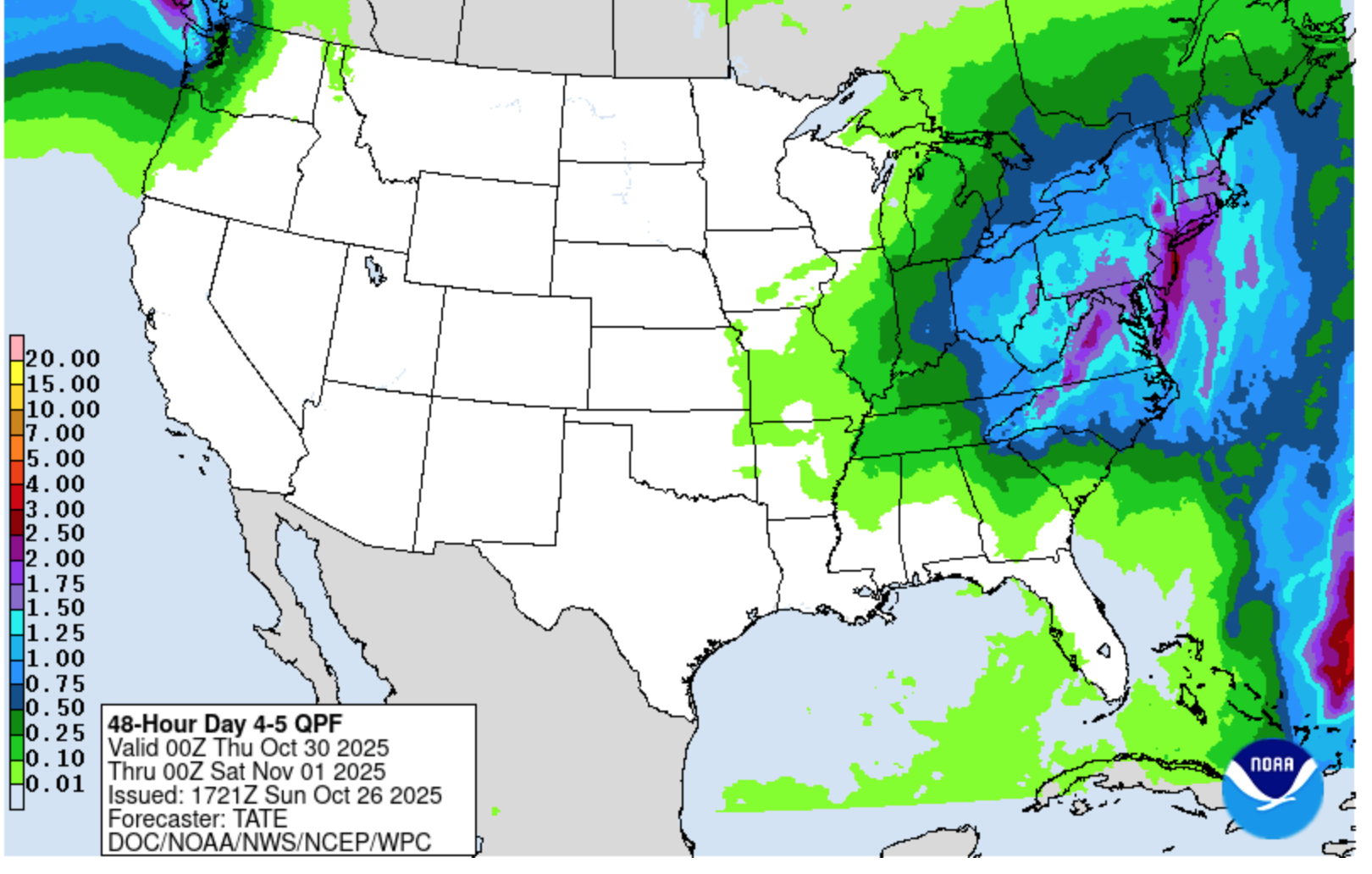
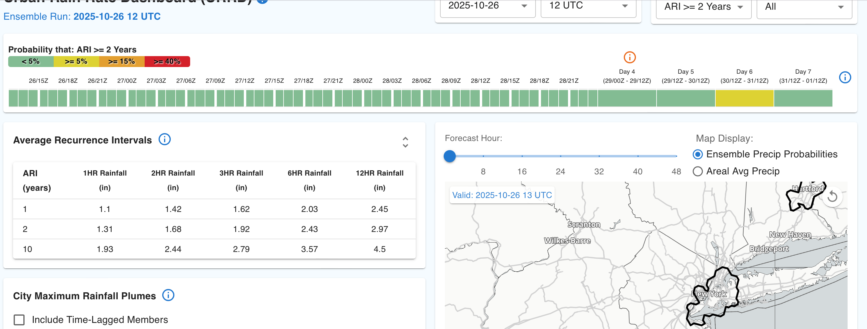
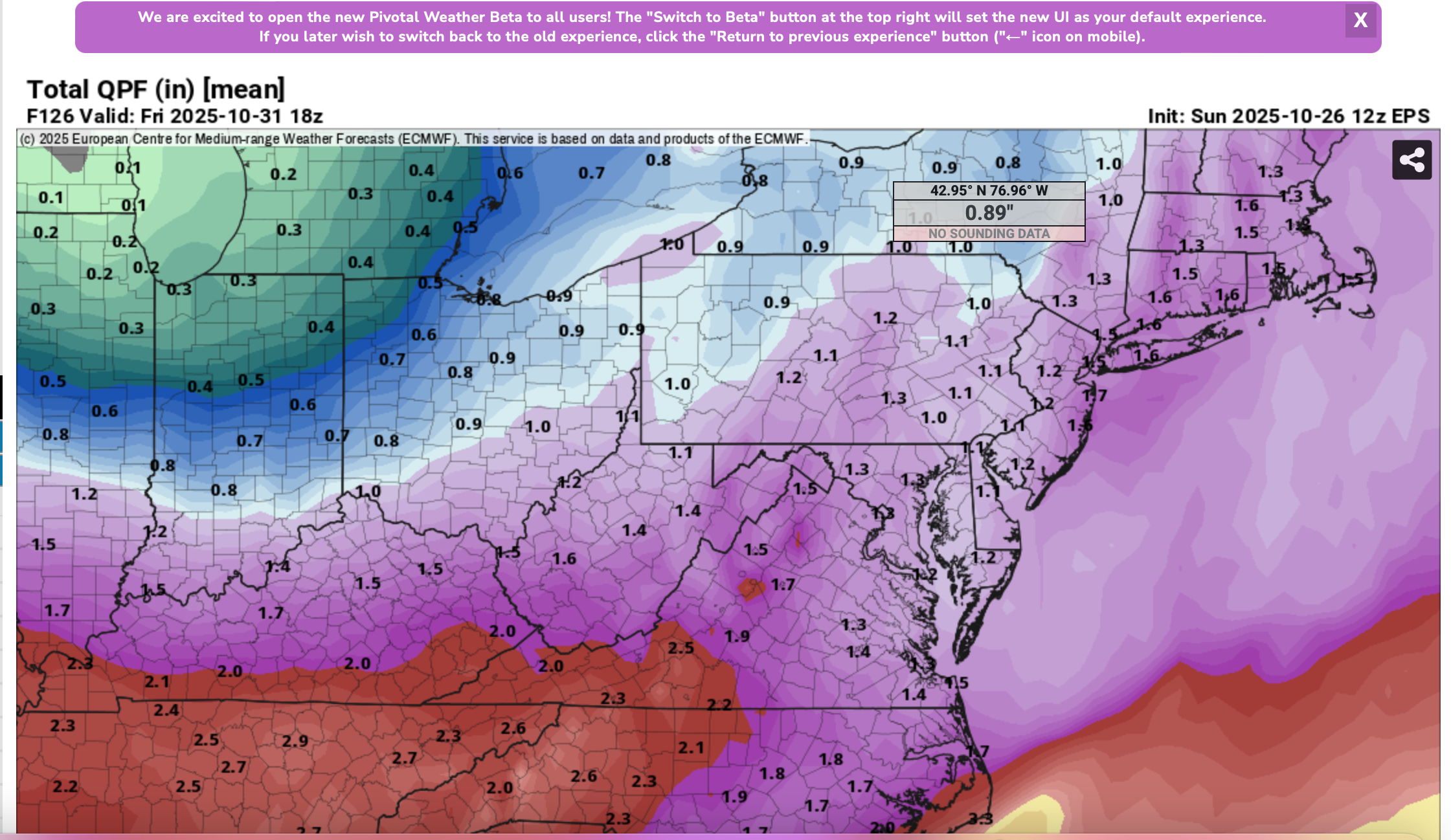
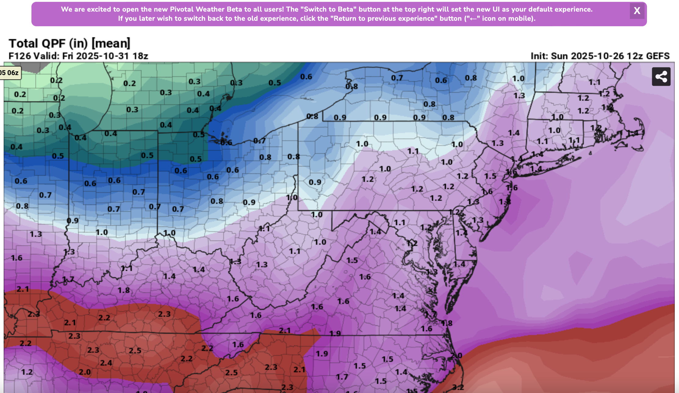
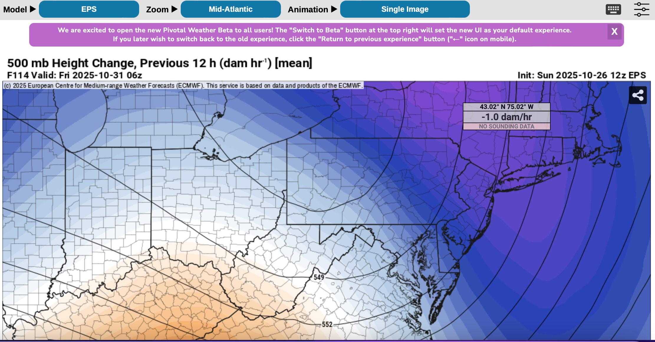
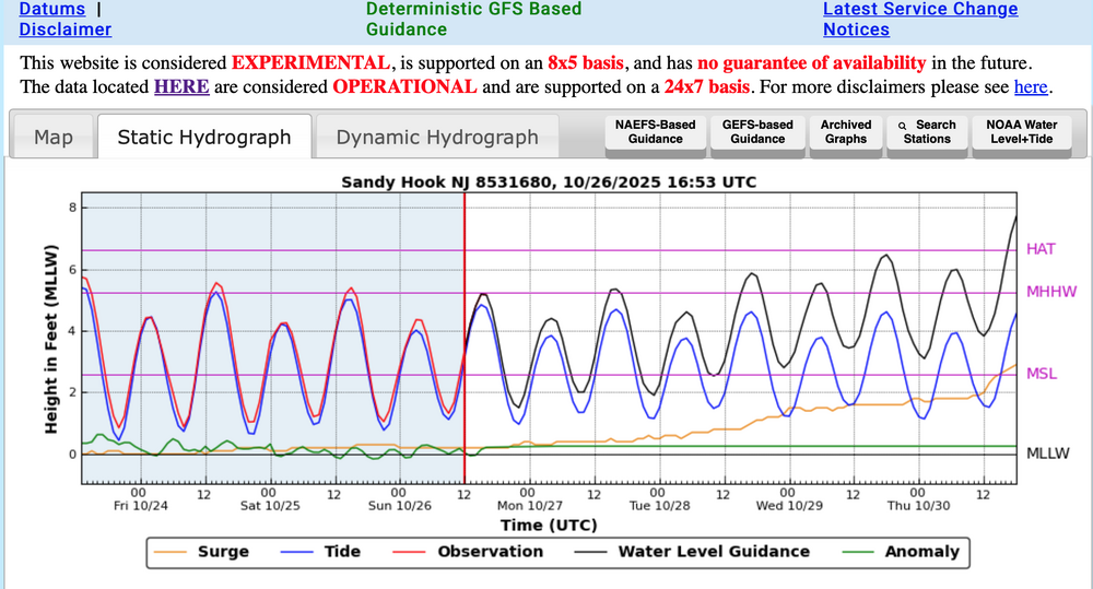
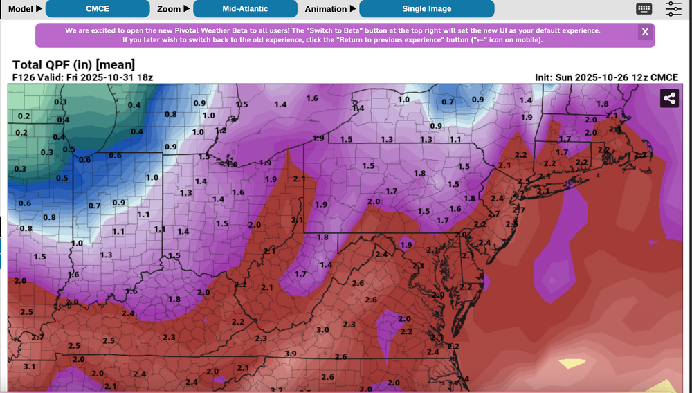
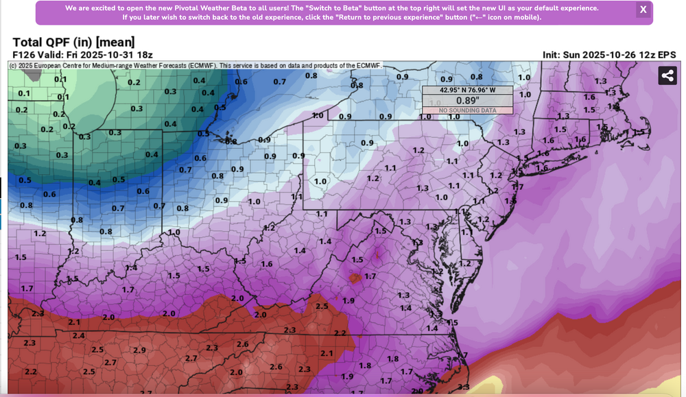
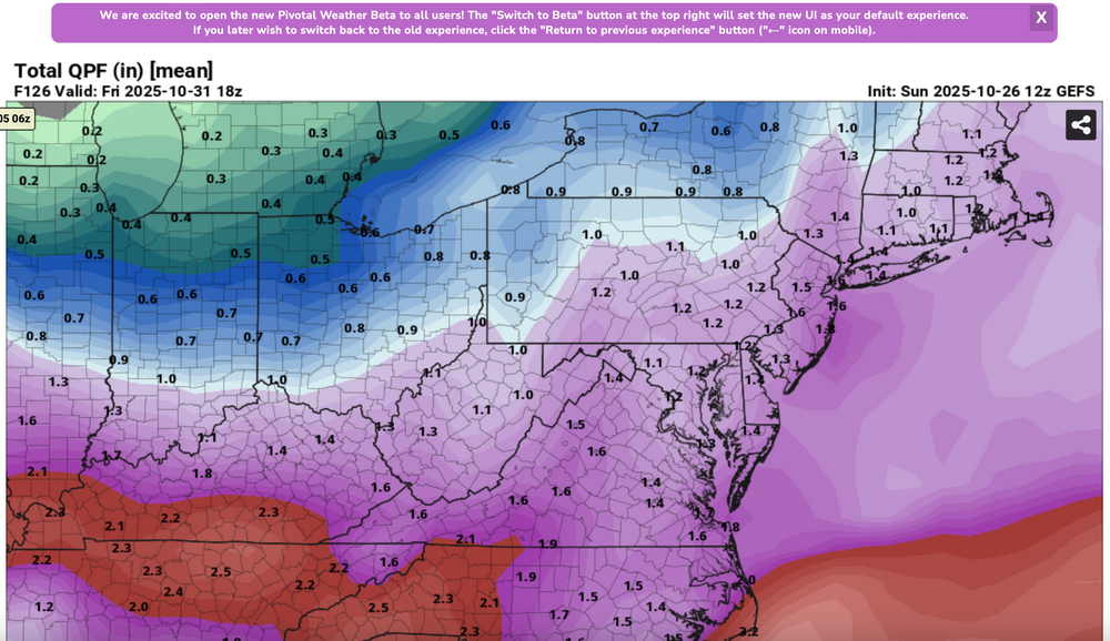
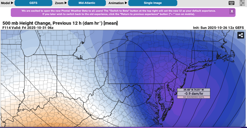
 Please follow any NWS Watches, warnings, statements that may arise from this coming minor or moderate event. This is a D4-5 advance heads-up thread for those who have a need to be advised. Modeling has plenty of spread in solutions so that the ensembles are somewhat muted. There is no doubt in my mind that some sort of minor or possibly moderate impact event is coming. Modeling has been wavering for the past 4 days and hopefully uncertainties resolve by mid week. If I had plans as a motorist or via air travel Thursday-early Friday, I'd think about delays and how to minimize adverse impact, then possibly implement changes Tuesday or Wednesday Timing of the 6-10 hour worst case is uncertain. Beneficial rainfall should result in October totals at all NWS OKX-Upton climate sites roughly 3.3-4.3", within about 1/2" of normal. Not everyone will get 1"+ but the attached Sunday afternoon 10/26 WPC guidance is a best estimate for D4-5. Rainfall still could end up less than indicated. A graphic of average return interval (ARI) for various event amounts, at NYC, is attached-not alarming. This could still end up a routine event although I think wind can add impact. Rainfall intensity during one of the rush hours combined with potential for a period of east-southeast wind gusts 45-55 mph on the remaining wet fully leaved trees may result in a scattering of broken limb caused power outages, similar to the 10/12-13 event. Lunar cycle argues for maximum worst case coastal flooding in the minor category. Modeling from P-Surge is attached. It might be too robust (follow NWS), suggesting a worst cause 3 ft surge along parts of the coasts during the Thursday afternoon-evening high tide cycle (using Sandy Hook as example). Lowered pressure this time compared to 10/12-13 contributes to the surge. Please be aware ensembles are not showing much more than 50-55knot se inflow here, limiting potential for excessive rainfall and surge. There is a slightest chance for isolated severe however CAPE seems to be very limited, despite the favorable strong shear and diffluent upper level flow. A 100-150M 12 hour 500 MB Height Fall Center circles northeastward from the southeast central USA into PA/NJ early Friday. That helps drive the relatively short duration heavy rain event. Presuming the upper Low continues to evolve northward through PA into NYS the eastern Great Lakes there should be a progressive rapid improvement sometime Friday morning. Westerly winds may gust 25-35 MPH at times during Halloween evening but hopefully without any showers in the area. Ensemble rainfall from several modeling centers has been attached as something to look back upon Saturday 11/1 when all the totals are in. The 500MB ensembles attached also show the 12 hr HFC. Fairly modest in comparison to some of the operational cycles we've been seeing the past several days. If the 5h ensemble pattern prevails or is further west, then we've tracked a routine event. The thread current headline will eventually update if moderate impact potential decreases. For now this hopefully adequately summarizes what is on the table for rain/wind/coastal concerns. Let's see if its worth tracking. 620P/26
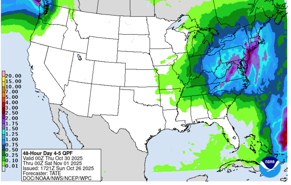


- 246 replies
-
- 12
-

-

-
- heavy rain
- damaging wind? squalls?
- (and 2 more)
-
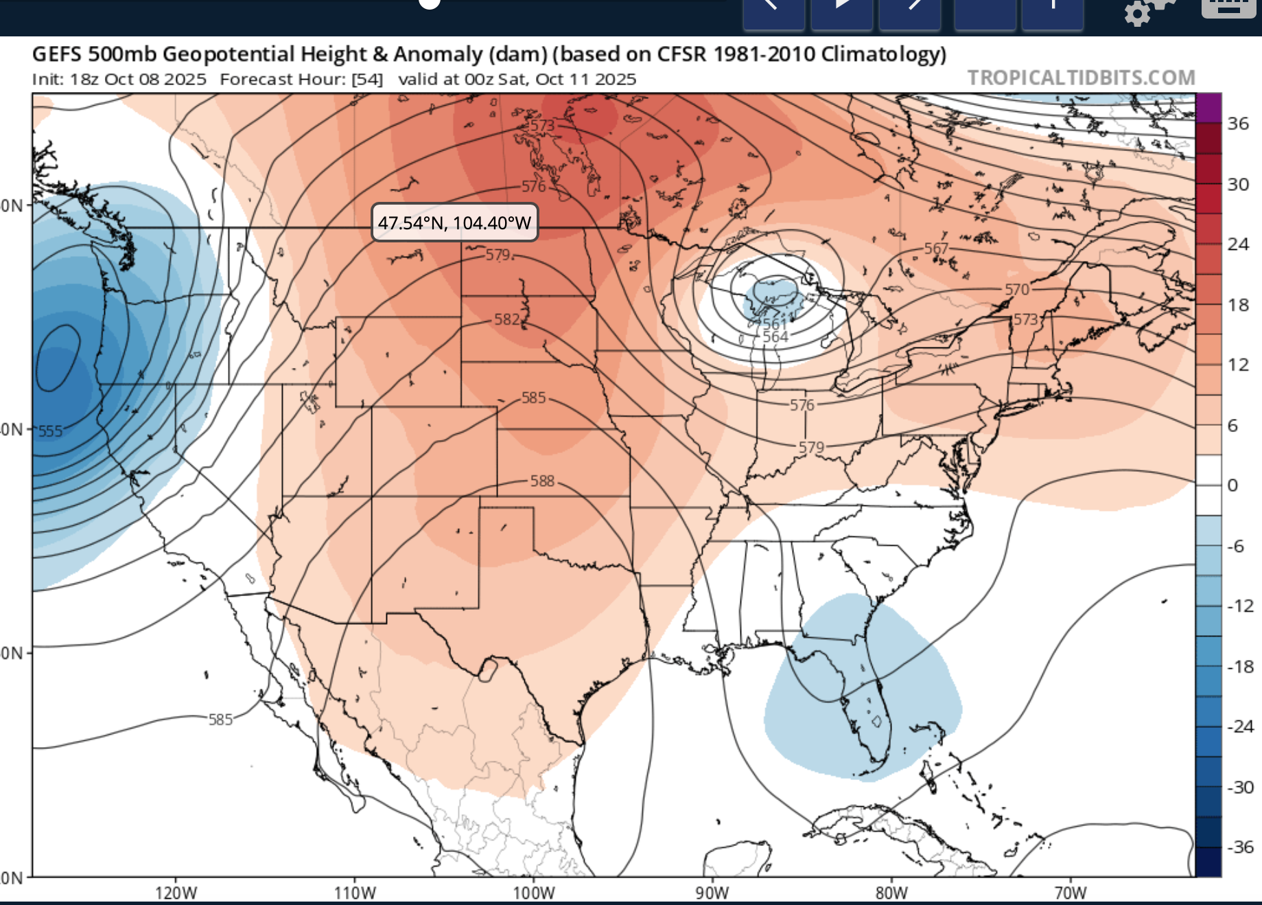
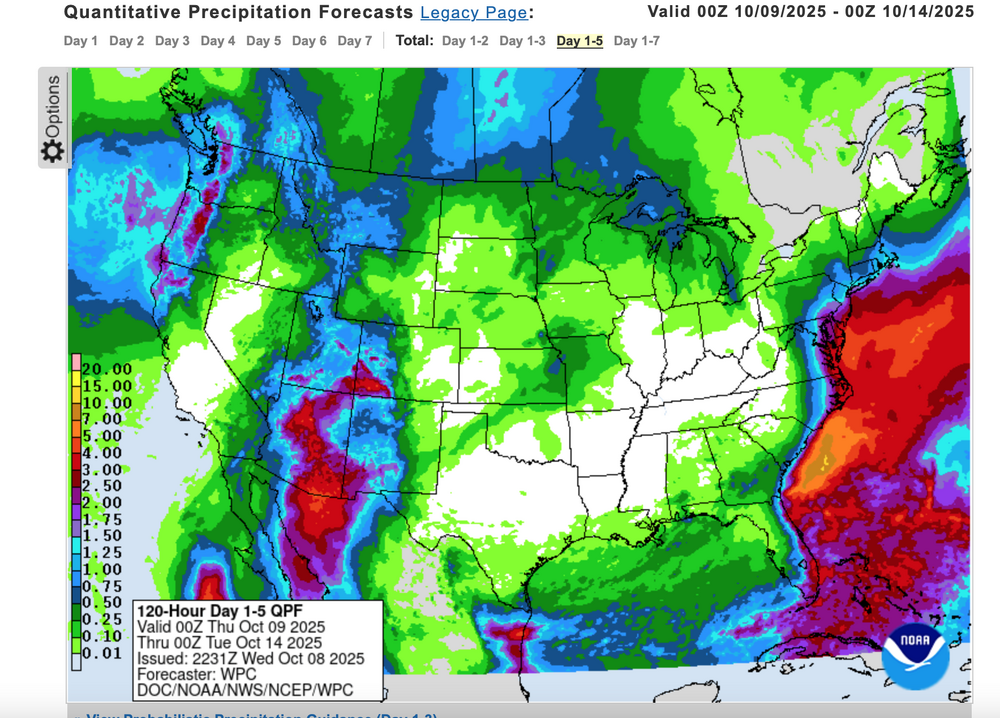
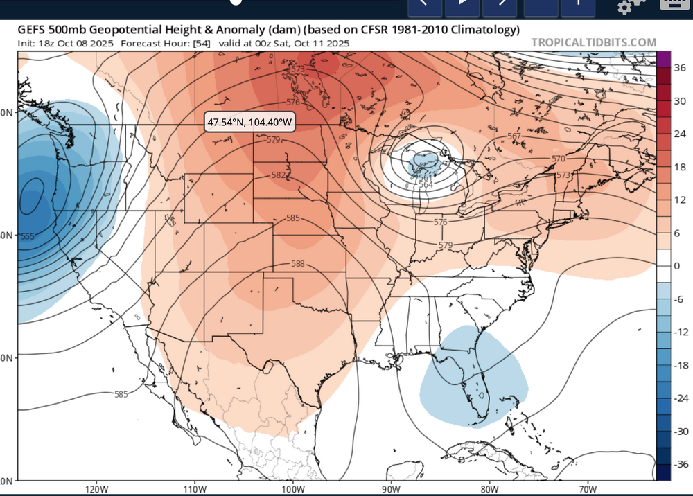
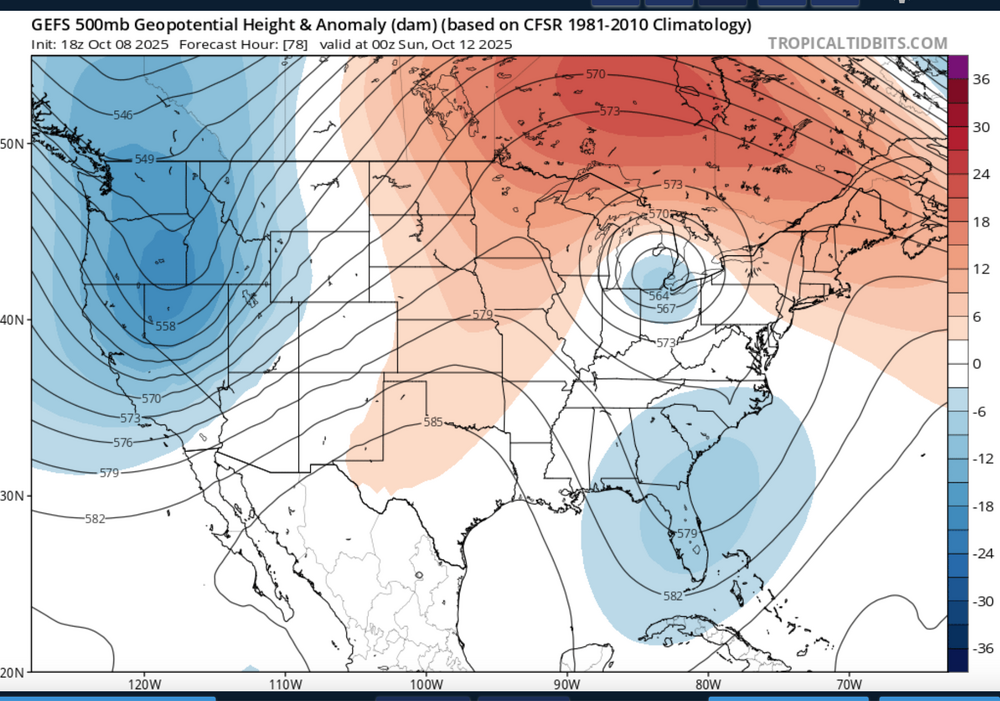
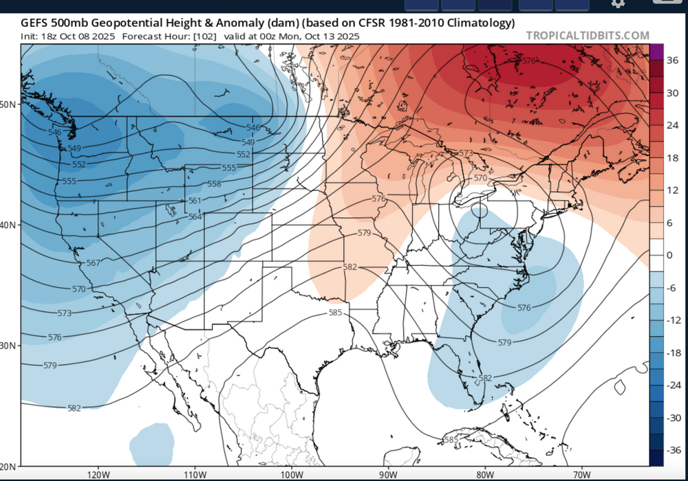
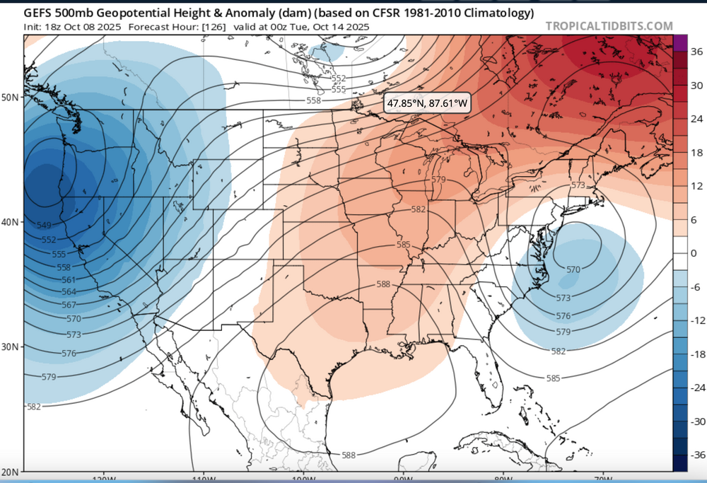
Nor'easter coming Sunday-Monday though track uncertain ranging from coastal hugger e of NJ worst case scenario to further southeast and less impact. Graphics added are the Wednesday afternoon's WPC 5 day rainfall forecast ending 00z Tue 10/14, The WPC D5 concerns for excessive rainfall issued this Wednesday afternoon - Isolated 4" in the slight risk area but general 1-2" foreseen for much of the NYC subforum between 6AM EDT Sunday and 6AM Tuesday. Also added 4 successive 24 hr forecasts of the evolving 18z/8 GEFS 5H field which I hope repeats this winter... a phaser with a southeastward diving cold core strong short wave through the Great Lakes this weekend that ingests-draws northward - the moist trough currently developing along the se USA coast and results in a fairly intense storm along the mid Atlantic coast by Sunday. The EC EPS 24 hr max wind gust tool has been cyclically consistently offering 60+ MPH in the western Atlantic and 50+ MPH along parts of the NJ-LI coasts. If this occurs, in conjunction with heavy rainfall, fully leaved tree branches would break or even uproot in some locations. No guarantees on wind strength at this time The strong chilly high pressure system that is developing into our area now will become part of a eastern Canada block and set up a strong easterly gradient over our area and should result in multiple cycles of at least minor coastal flooding with a pretty strong potential for at least one high tide cycle moderate coastal flooding (even outlier LOW PROB spotty major) for either the midday Sunday or midday Monday high tide cycle along the NJ coast. Full moon is past us so the astronomical higher tide cycles are lowering and helps reduce the chance of more than moderate coastal flooding. Still this is 4-5 days away, so intensity, track and system evolution are not locked into a worst case scenario and will ultimately determine impacts. Erosion will occur...severity unknown. It appears the ECAI has been most cyclically stable predicting this storm for our NYC subforum dating back to I think the 00z/4 cycle. Did not look at standard deviations departures of the 850 MB inflow but suffice to say, its stronger that normal. PWAT generally near 1.5" minimizes potential for much greater than 4" though the 2" PWAT axis lies just offshore. Thread headline Original thread headline below, adjusted 422 PM Saturday 10/11 "Potentially" powerful Nor'easter Sun-Mon 10/12-13/25 with needed rain-especially south of I84, and fairly high impact sct coastal gusts 50+ MPH and possibly moderate or greater coastal flooding at the midday Sun and Monday high tide cycles. posted 741PM/8

- 731 replies
-
- 9
-
-
-
- heavy rain
- damaging wind
- (and 2 more)
-
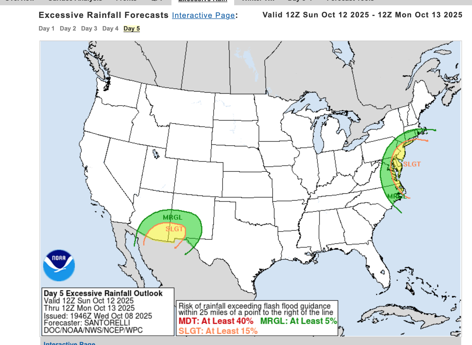
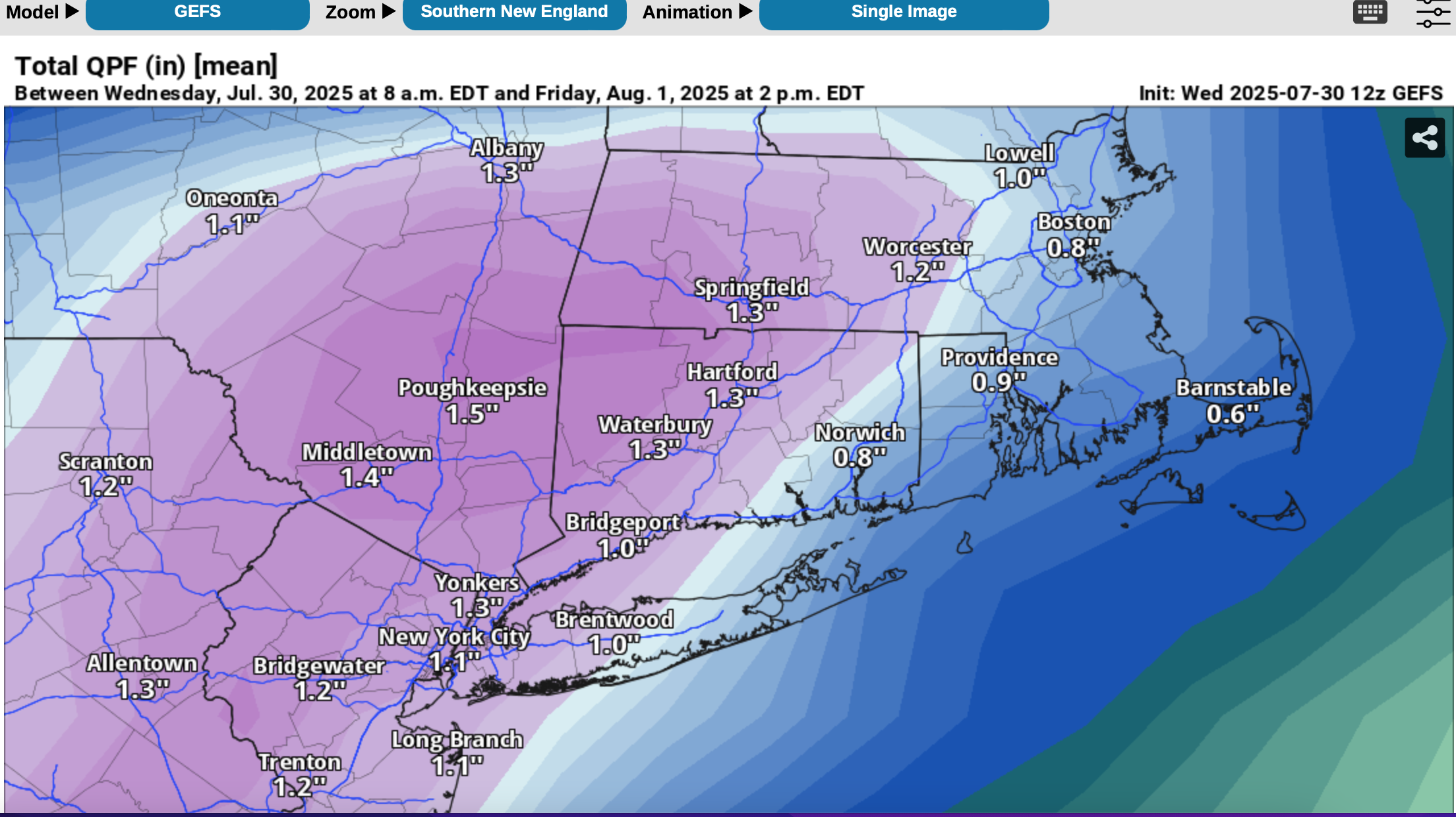
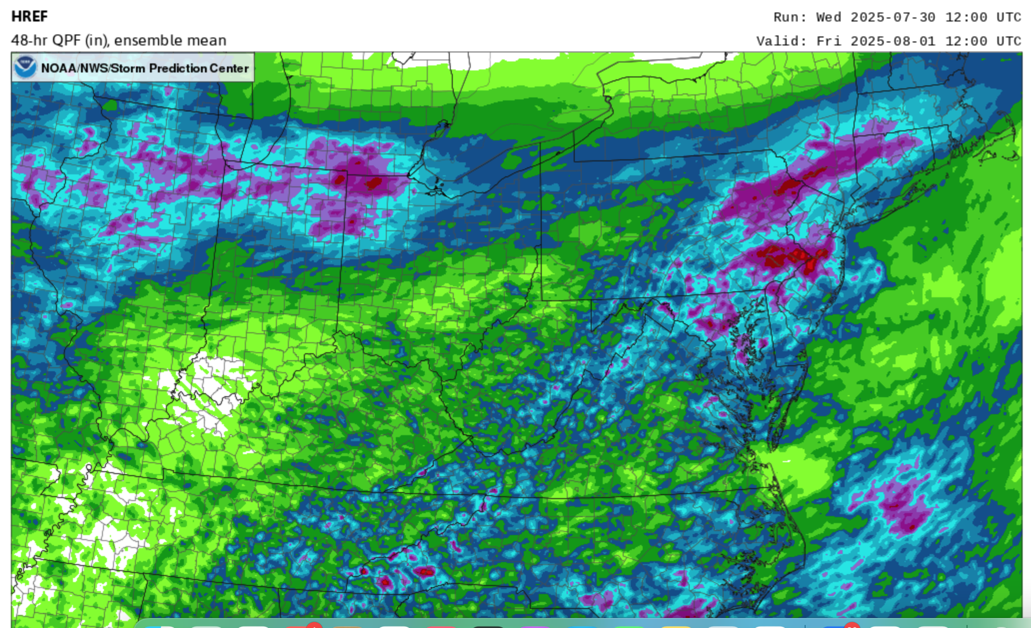
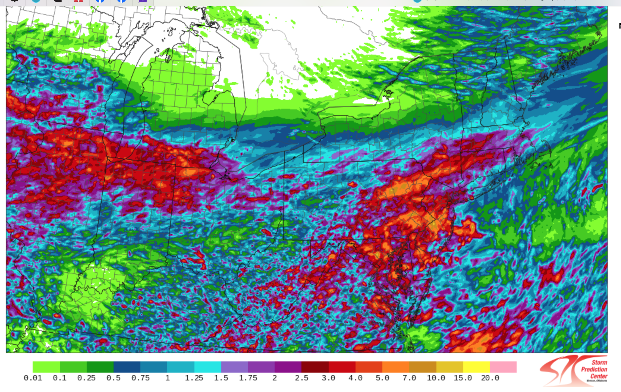
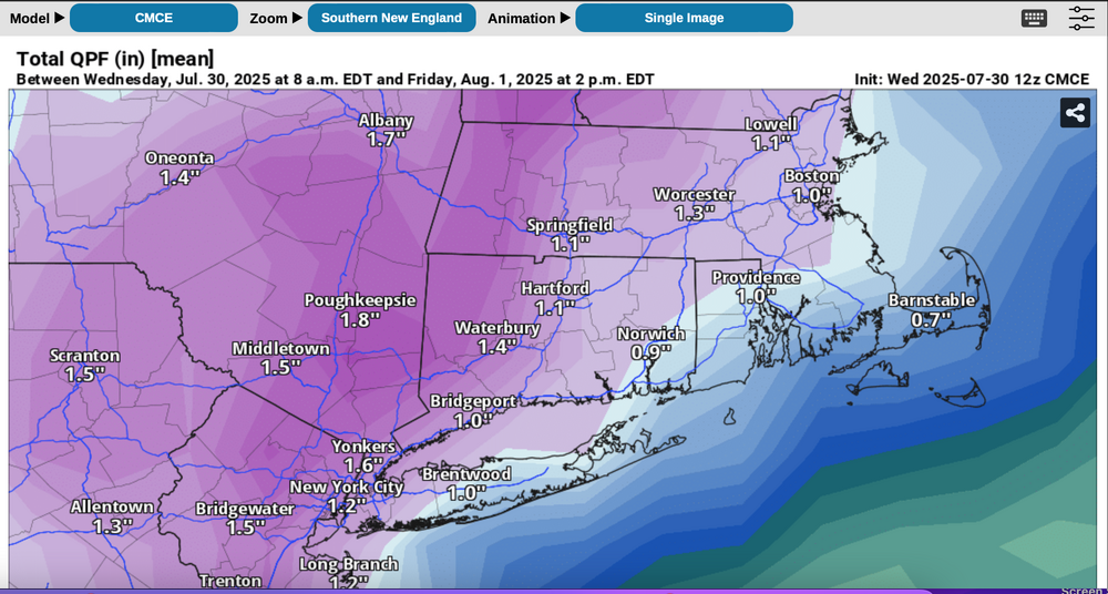
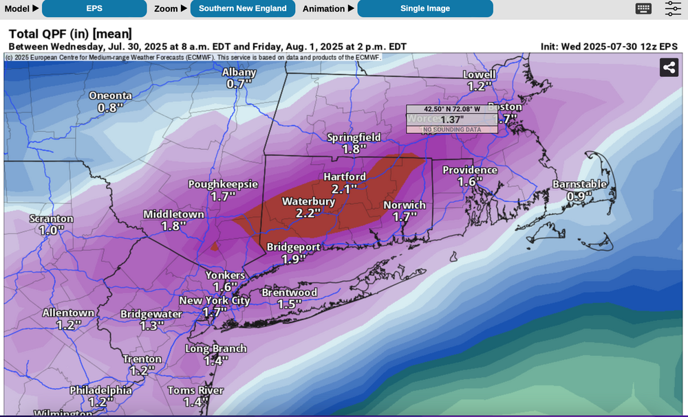
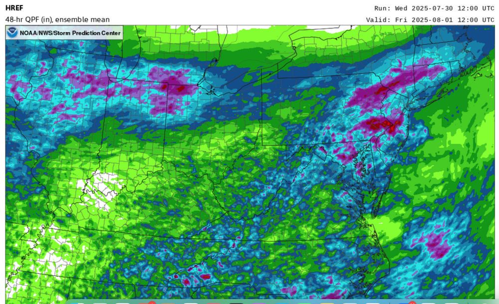
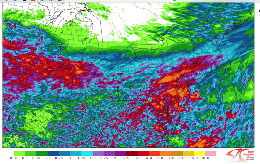
Follow NWS warnings-statements. A flood watch has just been issued by the NWS for a portion of the NYC subforum. I'd prepare for some delays Thursday-Thursday evening, possibly a few detours. If a road is flooded, don't cross it---turn around-done drown. Not worth the risk. We dont know where exactly 4+" of rain should occur but the potential exists as a slow moving frontal boundary possibly ends as a near northeast gale for LI. Plenty of PWAT (1.5"+) along with the RRQ of a strong confluence zone 5h-3H et across northern Maine-the Maritimes causes large scale overrunning of the southward sagging frontal boundary Thursday-Thursday night when the bulk of the heavy rain occurs. For now, it appears the region from I78 northward is vulnerable to excessive short fuse runoff but the HREF added graphic shows the isolated 7+ inches POTENTIAL(browns from the legend) just south and west of our NYC subforum. Nevertheless, this should be a somewhat interesting 48 hour period. For reference have added the 12z Wed 7/30 ensembles CMCE, EPS, GEFS as well as the 48 hour MEAN rainfall from the SPC HREF ending 12z Friday with magenta 1.5"+, and the MAX potential rainfall from the HREF which suggests isolated 7-possibly 10" but primarily southwest of the NYC subforum. See legend but dont take location verbatim and. dont necessarily believe 7+ can occur. Antecedent conditions are not excessively wet so large rivers are not likely to flood, but small streams, especially near urban areas could see overflow Flash Flood response.

-
Good Tuesday morning Dec 10 to everyone... I'm hoping patience works for winter snow - NYC metro. In the meantime, a fairly high impact storm is likely with potential for a squall line forming NJ coast into w CT during Wednesday afternoon contributing to downward transfer of some of the 80KT Southwest Jet. OKX already has High Wind Watch for the primary damaging wind threat area. I've added a few starter graphics-click for clarity. Includes base maps of NWS rainfall, wind gusts and also somewhat differing opinions of the Excessive rain potential from the 00z/10 guidance. One personal note of concern: Drought monitor and excessive rainfall potential don't seem to be a coherent match but I haven't checked everything regarding the monitor. 8A/10
-
Periods of rain, some of it heavy at times is destined for most of the NYC subforum Friday-Saturday as low pressure develops off the mid Atlantic coast into a vertically deep slow moving cyclone. PW increases at times to near 1.7" in warm advection along the inverted trough Friday then the pinwheeling PWAT circles back around our area Saturday. Gusty northeast-east winds Friday morning to 35 MPH and the constancy of northeast flow this week at the time of the highest tides in Sept should yield at least minor coastal Flooding within 2 hours of high tides Friday and possibly moderate coastal flooding at the highest tide cycle Saturday or Sunday as the backwash of the offshore storm shoots some 45 MPH north-northeast winds down the NJ coast by Sunday morning. The previous 3-4 day rains are attached, and the numbers for this coming one may exceed 6" again in parts of the NYC subforum. If so, where? It's possible, despite all this projected rain, that flooding might be imited to a few small areas. Too early to be sure as of 447PM/27. The EPS has been most aggressive with this system since 9/24 cycles and the 12z/27 EPS mean rainfall is attached. These values are quite high and much higher than the GEFS 12z/27 cycle with the GEPS midway between. If it causes fresh water flooding---where? Not sure this will be very much freshwater flooding except possibly NJ/CT/urban LI. This topic should serve also for the rainfall reports. at 505PM added the tag power outages. If this rainfall develops per the more aggressive 12z/27 EPS mean, rain softened ground from this past weekend combined with new 2+" rainfall may allow spotty power outages due to tree uproots of still fully leaved trees.
- 886 replies
-
- 3
-
-
- heavy rain
- flooding potential
- (and 2 more)
-
The above hopefully encapsulates the likelihood of two upcoming significant east coast storms. Changes will occur from the some of the attached supporting graphics but we're in line for more significant weather and I'm sort of concerned about flood potential. This time maybe wet snowfall NYC.? Please consider limiting NYC snow enthusiasm with the stats attached from Don, at least until we get Jan 4-5 (if snow is still in the possibilities). It is hoped the Bluewave produced lack of 2" snowfall at CP can be put to bed, but it's possible that next Sundays probable wintry event will shift a little more inland with rain dominating along the coast. The event for the 10th could be brief snow or ice to heavy rain and snow melt, presuming we accumulate anywhere close to the attached 00z/31 EPS prob of 4" axis. Wind damage graphic via the EPS for the 10th... expectations are more of an e-ne wind (nor'easter we hope) for the 7th with gust potential 40-50 MPH along the coast and maybe minor coastal flooding (tide cycles are LOW for this storm). The event around the 10th "may" have stronger winds gusts vicinity 60MPH along the coast and a better chance of coastal flooding (tide cycles 10" higher to start). Power outages possible but impossible to predict without 24 hour confidence on wind gusts/qpf amounts/ptype/temp if and when it snows. This thread was started since I think there is general interest in snow, also flood potential for this weather interested forum. I may comment once/day but it's all yours. OBS for the 6th-7th will go in here. For whatever occurs the 10th...may have to separate out the OBS in a supplemental thread late 9th, but that's 10 days away and at least a portion of these ensemble expectations may be less than out looked through the 00z/31 cycle and therefore less impact and more routine. No guarantees here but definitely worth monitoring. Edited title 1156AM-Jan 6 to include obs and tags added obs and sleet. Edited title 645 AM Jan 8 iso include OBS for Jan 9-10 and removed the ? behind damaging wind.
- 3,610 replies
-
- 11
-
-
-
- snow
- heavy rain
- (and 5 more)
-
Added 12z/26 Blend of models rainfall, the WPC 22z/26 three day rainfall forecast, and a sample from the 18z/26 HRRRX ending 18z/Thursday, which in my mind shows the potential narrow axis of 2-3"+ of rain. If that ends up over the Passaic River Basin, then minor flooding would resume on parts of the Passaic. We'll have to wait for reality to know what will result. There should be an axis of 2-3" rainfall near I95 and it could result in moderate impact for travel Thursday morning. This in addition to the overnight-Wednesday morning dense fog impact will mean some difficulties for air and surface travel. An additional 0.2-0.6" could fall in the NYC subforum 1P Thu-7P Friday with bands of rain/drizzle in the convergent surface trough region west from the departing low pressure system off New England, and to the north of the weakening upper low moving eastward off the mid-Alantic coast. If 2 inches occurs in Central Park by Friday night, that would push December into the top 5 rainfall (7.12"), and the year to #11 (59.23"). Central Park rainfall seems to have a pretty good chance of exceeding 1.5" but there is always uncertainty on qpf. So, another significant rain event is on the way. The 48 hour qpf from the SPC HREF, HRRR, RRFS from 00z/27 and 12z/27 cycles could be helpful perspectives if and where the potential exists for 3" of rain from this event. This thread headline and/or tags may update if the NWS issues flood watches.
-
Please follow National Weather Service warnings/statements. Starting from another 10 degree morning in NYC, a rapidly changing weather scenario will cause some power outages, accidents (despite a Holiday weekend) and slippery travel for a time in a fairly large portion of the forum, in part due to at least 42 consecutive hours of freezing temperatures on non snow covered ground, and beginning near sundown when the impact of solar insolation lessens. Exactly who gets how much of what is being determined by member observations with model and forecast contributions enhancing, but not hyping interest. Coastal flood threat as per OKX. Usually we like at least 12 hours of gale force onshore flow to build the water levels, but with the astronomically higher tide cycle, 980s MB pressure at Monday morning high tide, an inch of rain in the 6 hours up to high tide emptying from rivers-streams, there should be enough surge and incoming wave action to cause coastal flooding. Working a bit against the flooding NYC southward along the NJ shore is the onslaught of wind abating and turning southerly near the time of high tide. Certainly the early part of the morning high tide cycle looms larger. If you're in a tidal inundation area, follow NWS statements. I'd park my car with parking laws in mind where it can't get flooded. Wind damage: several 12z/16 HRRRX graphics are appended. Please use the legend. Midnight to 6AM is best chance for damaging wind , to occur in a 3hour period ranging from near 2A NYC to near 5A e LI. Gusts to 60 kt possible e LI with gusts 45 kt possible NYC metro airports. I could be too conservative. Have cell phones charged and be prepared for no internet early Monday. Many of our members, even to western LI will be reporting a bit of snow or sleet late today (some are from Ocean Effect already). mPing will be helpful especially for us inland folks just north of I78 where an hour or 2 error in the precip phase change from snow to sleet/freezing rain or rain can mean an inch or two of snow. The 12z HRRR, HRRRX, and 3K NAM seem to support slightly more snow than maybe some are anticipating. Whether that occurs is unknown. No matter, if you have heart problems and live north of I80, you may want some assistance removing slush laden with maybe 3/4" of rain (glop). And of course have your resources to clear it by 6PM Monday when temperatures falling below freezing start the solidifying process. {The HRRRX amounts may be too large by 2", so it is a slower to change model with 1/4-1/2" everywhere up through I84 by 06z, so that could bias the amounts high there. edited in at 1036AM} ICE: I think parts of the I84 corridor including Sussex County NJ may have pockets of damaging ice near 4AM Monday when the ice combined with wind gusts 45 MPH in the ridges could be enough to knock out some power. Monday afternoon-evening: The trough aloft passage and influx of colder air should wring out areas of 0.1-1" snowfall in the steep moist lapse rates associated with the cold pool aloft, including NYC-LI.
-
Active Pacific pattern assisting downstream northeast USA blocking of two large 500MB trough passages next week. This should result in at least one Nor'easter and possibly a classic fall severe weather event if a 985MB low moves northward through central PA. Max isolated rainfall potential of ~7" somewhere in the NYC subforum (interior) would lead to isolated Flash Flooding but the dry October of generally less than 1/2" so far in NYC 'should' limit the flash flood threat. There has been more rain I84 northward so the flood threat may eventually be targeting the interior NYS/CT portion of our forum. The general non-astronomically high tide cycles should at least partially limit the potential for moderate coastal flooding. Of greater concern appears to be softening of the ground by next weeks rains and the probability for a period of 45-55MPH wind gusts on fully leaved wet tree branches in parts of the area, which would lead to a power outage problem. At this Friday October 22 608AM issuance time, it's far too early to focus on the details. The headlines of this topic will adjust a bit as we move through the weekend, including tags. For now have left SVR and FF out of the tags. 430P/Saturday the 23rd added the FF Tag. 7P/Sunday the 24th increased general rainfall to a range of 2.5-8" up from 1.5-4".
- 306 replies
-
- 4
-
-
- heavy rain
- damaging wind
- (and 1 more)
-
This first event is slated mainly for Monday night-early Tuesday night but with a pulse of showers, some heavy occurring overnight Sunday night and potential for bands of high wind and or heavy rain remaining in the NYC subforum into early Wednesday, depending on the departure of the eventual nor'easter. Max gust for e LI may get close to 70 MPH with wind damage 'potential' of 50 MPH gusts s of I84 in CT into far se NYS through ne NJ. Fully leaved tree branches with potential for sodden ground uproots Tuesday due to heavy rainfall and the gusts should result in pockets of power outages from simply broken branches. If it looks extensive, we will update the topic title. Max rainfall seems to be targeting CT/se NYS/NYC metro-ne NJ but proximity of max inflow-moisture transport still showing modeling variability for the primary target. In any case... it appears likely that along and north of I78 there will be periodic showers overnight with new rainfall by sunrise ranging from a few hundredths to possibly 1". After a break Monday, bands of heavy showers should be developing north and northwest into the area Monday evening and slow their northwest to west progress Tuesday before turning southward later Tuesday night. By 8AM Wed, isolated 6" rains may have occurred with a general 1.5-3" in the subforum. FF potential while initially limited by recent dryness, the rainfall rates and amounts in banding will eventually determine where any FF potential will be realized-it's just too early to determine, as of this 720PM Sunday writing. Please follow all future NWS warnings/statements. Let's see what the OBS herein tell us about the modeling by Tuesday night. Edited title rainfall up from 1.5-4 iso 6, to 2-5, iso 8. Edited title at 1025A/26 to like 40-60KT gust focused on CT-LI.
- 228 replies
-
- 4
-
-
- heavy rain
- flash flooding
- (and 2 more)
-
September second dawns with NYC having been doused with ~7.2" of rain from the remnants of IDA, resulting in death and major flooding in the NYC metro area. September normal rainfall is about 4.31". The target is 10" for September, which is possible and would be a first time in the 150+ year history (POR back to 1869) of CP record keeping. AND, iffff we get to 10", can the 3 month total in 2021, exceed the 3 month ASO 2011 total of 34.43"? There may be opportunity, dependent on the latter half of December steering flow. Have not checked other 3 consecutive month totals for CP in the database, so there may be an even larger value somewhere in there.
-
Nowcasting the the frontal boundary period of strong thunderstorms w heavy rain, lightnng strikes, hail, mainly along and south of I80 this evening. NYC seems to be on the north fringe but worthy of monitoring. There may be a second batch after 1AM Tuesday?
-
650A Tuesday Aug 31: adjusted headline with mdi-iso Major impact esp NJ/LI, Dropped PRE since no TC and therefore no criteria. 6AM Sunday August 29 thread title update. Added general 2-8" rainfall, added possible PRE, and withdrew the ? of direct or indirect. Description of increasingly likely impacts around 7AM Sunday. This issuance makes the presumption that IDA will be our next Tropical Storm and move north into the Gulf states, shearing out into the Northeast or mid Atlantic states 500MB confluence zone next week. For now the risk of all the tags above is low, but worthy of monitoring. It's possible our first rain (if indeed IDA spreads rain into our NYC subforum?) might arrive late on August 31st. Think at this point, antecedent soil saturation and streamflow conditions will assist determining whether there will be any renewed stream flooding, if indeed IDA does dump a stripe of 3-6" of rain in a portion of our subforum. Chance of 35+ KT wind gusts is also low with the main contribution of IDA, rainfall, to Septembers total. Tides are fairly low so am not anticipating any problem with tides, at least not at this Thursday August 26th thread initiation. Attached the 12z/26 GEFS 500 MB membership for 12z Wed Sept 1 to show the confluence zone and also the 12z/26 24 hr qpf from the EPS and GEFS. For now these show a glancing blow to our south with a complete subforum no rain miss still possible, but not likely. The WPC Day 6-7 forecast issued 1622z/26 confirms the potential for at least some rain.
- 511 replies
-
- 2
-
-
- heavy rain
- tropical gusts
- (and 1 more)
-
Have started a low confidence thread since the impacts could be significant for part of our area. Ensembles imply that whatever the remnants of Fred, they track northward into the eastern USA with its own PWAT blob and potential for squally gusts of 30-40 knots passing into our very close to our area PA/NJ/LI southward to the Delmarva during the middle or end of next week. Indirectly and of interest to me is that the seeming evolving pattern will have a separate moisture blob somewhere in VA-MD, parked there by the Saturday morning CFP in our NYC subforum. That separate blob of moisture, I think, has a good chance of being pushed northward, into our area early next week, well ahead of the Fred remnants. IFFFFF, we get both blobs of RH overriding the northward drifting warm front, I think we'd be talking over 5" of rain somewhere in the mid Atlantic states. So at this early early stage as my own heads up: Do we see only the advance frontal moisture arrive next week, or do we receive leftover Fred moisture (possibly two fairly large rain events)? Added 00z/12 deterministic single member EC PWAT for early next week showing northward advancing moisture pools.
-
553P/12: South of I80 and also all of LI: probably no snow except possibly a short period of wet snow, melting on contact Friday. For the interior suburbs, especially elevations nw to ne of NYC, this could become a problem wet snow impacting power, and for those with heart conditions - safe removal of the water loaded accumulations. Shovels and plows may be of value in the hilly areas Friday morning,. Banding is likely to occur Thursday night-Friday in the northwest sector of the upper low that will enhance precipitation rates in some areas. EPS 850MB easterly inflow as of the 12z/12 cycle was twice that of the GEFS, Therefore, the ensemble snowfall yield from the GEFS is minimal - under 1" while the attached EPS is considerably more. It's too early to be overly confident of 6+" of wet snow, in parts of the extreme nw part of the forum, but certainly possible. IF 6" were to occur at 33F, I'd be thinking of power outages by 9AM Friday. Snow water ratio's may be less than the 10 to 1 used by the ensembles. It should be noted that the WPC Monday outlook for 3+" of snow is only spotty 10% chance in the Catskills. I think this is largely based on the GEFS. Still marginal temps and a breakdown in the 850MB inflow to a weaker GEFS solution would nix the risk of heavier snow. The bulk of any snow should accumulate during Thursday night, lingering into Friday with possibly a second batch of trailer heavier snowfall in the wraparound band Friday evening, especially CT/MA high terrain. As the snowfall rates lessen during midday Friday and afternoon, it could change back to rain. It is an interesting situation and not unheard of. Even last May 9 we had accumulative snow in some of the suburbs, so I don't think of this as a new normal. In summary: Looks interesting for the hilly areas northwest to northeast of NYC. How much and is it worthy of a thread, we'll know in 5 days. I'll be following the NAM/GFS positive snow depth change... that to me becomes the minimum to look for, once it is consistently established from cycle to cycle. And of course, Kuchera and NWS products. Small chance gusty winds 40-45KT e LI Friday?. Meanwhile, LI/CT/se NYS, ne PA should pick up a general melted combined rain/snow of 1-2", iso 3"?
-
Topic Edit 508AM: Added HIGH IMPACT and the time back in to the topic and extended 4 hours. Strongest winds in NJ/ne PA/se NYS roughly 10PM-4A, NYC/se NYS 1A-6A, LI/CT 2A-to possibly as late as 9A/25 e tip of LI. Minimum wind gust on LI 55 MPH with max 75MPH, NYC-se NYS minimum wind 50 MPH isolated max 70 MPH. Please follow NWS on all warnings/statements. I'll leave it yourselves to add graphics etc as need be. I'll begin an OBS-NOWCAST thread by 6A. Have not looked at soundings but everything else discussed in yesterdays 518AM topic edit below including HSLC SVR's continues. We may reach within 2F of the record 66F-2015 max temp for Christmas Day at CP. Flooding of some of the larger rivers, if it is to occur, may be delayed 24 hours or more after after the rain quits Christmas morning, Max rainfall axis in our forum looks to me to be CT, isolated 4", not including snowmelt runoff. If anything is missed, please let me know. Thank you. Topic Edit 518AM Wednesday 12/23: No significant changes. The prime threat period might by 2 hours too fast but not enough evidence to change the primary initialization period of weather related issues. My assessment tells me to prepare, without science, for many many thousands without power starting 9PM to midnight Christmas Eve evening, and then across se NYS, LI, CT, MA beginning midnight to 6AM Christmas morning. Gusts NYC airports should be 45-55kt, with potential for isolated 65KT LI/CT/MA. I expect SVR's for the HSLC lines of heavy showers to help focus the primary short-fuse threats. Lower chance of any damage northeast PA but ridges there will be most vulnerable there to ~ 55 MPH gusts. There is limited science on power outage wind damage with leaved trees, without, softer unfrozen ground versus frozen but I don't have this information nor any private services predictive algorithms. I still think that wind damage will prevail as the most important aspect of this storm, but please follow NWS flood watches, warnings as issued, due to the combined snowmelt and new widespread NYC subforum rainfall of 1-2", with isolated 4" potential inland-most of this in a 9 hour period during Thursday night, Any snow on the backside is exceedingly minor on the I84 high terrain. There actually might be a little better chance for a slight coating of snow Christmas night with the weakening trough aloft passage. --- Topic edit at 526AM Tuesday the 22nd: Changed the title to WILL be accompanied by damaging wind LI, and restricted the period of accumulative snow to the interior. I think the wind damage potential is the largest threat from this rapidly deepening 980s surface low moving northward up the front into NYS predawn Christmas. SVR's possible (in my mind likely, even if no lightning) for High Shear Low Cape (HSLC) heavy showers.The Richardson (R)#/wind profile combo on the NAM and even GFS tells me 45kt+ gusts all the major airports in NYC sometime between 10P/24 and 5A/25 . This is further supported by multiple models 80KT+ 850MB winds over LI, in some cases around 90-95kt. From my looking at R# and wind grab, this has the most favorable potential in my past 3 months of examining to realize downward transfer 50-65KT from the lowest 25 to 50 MB of the boundary layer. Whether an isothermal sounding in the lowest part of the boundary layer, or even a slightly inverted sounding can diminish-mute the potential, I don't know. What I do think, is that a lot of folks could wake up with lights out Christmas morning across LI, and possibly NJ/CT. Flooding potential to me looks the same as it did yesterday-previous days, all a matter of qpf, snowmelt combo to prompt a few rivers into minor or eventually moderate flood stage, even as temps plummet from 60ish near midnight Christmas morning, to near freezing by ~ Noon Friday. Please follow NWS closely on flood potential-they have more tools than I. Snowfall, accumulation less than 1 inch probably restricted in our forum counties only I84 high terrain northwestward. I'll copy this to the last page of this topic and add a couple of wind profiles there. The future posts will look at FOUS BL winds, which I think will exceed 34kt at LGA and BOS around 06z and 12z/25 respectively. IF not, then I'm a little too severe on my wind expectations. Also, I'll be adding shorter term wind gust potential graphics, especially Wednesday onward. (corrected many typos 826A) --- Below from the origination date of Friday evening the 18th. This topic is started primarily because of the recent operational model cycles at one time or another offering a more than ordinary 12-18 hour period of weather here near Christmas, on top of melting snow. Always uncertainty. Uncertainties abound, including how far inland can a couple of hours of 60 degree temperatures penetrate to melt the snowpack, and will there be any hazardous snow accumulation closer than the hilly western and northern suburbs? Add to that, is there an inversion thats prevent excessive low level winds from reaching the ground.? Snowpack will be melting a bit the next few days,, til a sudden brief surge of 60 degree warmth Thursday evening or very early Friday morning, associated with a strong cold front. That front is embedded within a high amplitude trough. It's slowed by a strong 1030-35MB high anchored near the Maritimes, and there is potential for northward moving low pressure along the front, as it traverses across the NYC forum. Max rainfall should be concentrated just inland (se or sse surface wind) and combined with remaining snow, may? be enough to promote some small stream flooding? Flooding will be dependent on how much snow melts on the 24th/early 25th combining with around 1" to possibly 2" of rain, prior to the sharp cool down to near freezing by midday the 25th. Current 12/18 river response models to multiple ensembles are not alarmed at this point so I don't want to make this look worse than it will be. Of greater concern is the ECMWF cyclic offering of 60+ MPH gusts to LI (50 inland) which may cause some damage. Recent experience with the storm of the 16th-17th suggests to me, that we will need at least 60 MPH gusts to see significant damage along the coasts and ridges. It's possible - IF the 850MB southerly jet can exceed 75 knots, preferably 85 knots. The 18z/18 GFS has 80 knots for e LI and the 12z/18 EC has near 100 knots for all of LI. IF the ECMWF were to verify, it would be lights out for many and not a pleasant Christmas morning. Timing of the event probably sometime at night (6P/24-6A/25 EST) Snow: Backside snow doesn't often accumulate significantly with temperatures falling rapidly from the 60s to near freezing. Thinking best chance I84 corridor high terrain sometime Friday morning the 25th. Graphics: 1) 12z/18 EC 850 wind. EC surface gusts, GEFS chance of 60 MPH wind gusts early Christmas and finally, the WPC qpf forecast from ~18z/18. 608P/18
- 227 replies
-
- 7
-
-
-
- heavy rain
- flooding potential
- (and 2 more)
-
Good Wednesday morning everyone, I've followed a recent example on the New England forum and offer this topic as a start over at 1PM with obs-nowcasts. The tags included hopefully cover the gamut of potential amounts. If we are certain about daily records being exceeded please add and ditto if we get top 20 at any xmacis climate site. Thank you all for contributing to the excitement-anticipation of a pretty good nor'easter.
- 1,011 replies
-
- 3
-
-
- heavy snow
- sleet
- (and 4 more)
-
Edit topic: 525A Wednesday 12/16: No change in thinking including uncertainties along I95. I just cannot shake the basics: S+ axis is usually 90 miles left of the 850 low and the northern half of the 700MB low and the deformation zone near 500 MB with contribution from the nose of the 850MB 50-65 kt easterly jet (moisture transport). This favors I84 and banding casts northwest to a central PA - east central NY area (roughly IPT-ALB) where 20-25" seem probable within 60 miles of that axis - at least in the high terrain, but must consider mountain shadow lesser amounts in the leeward valleys. There a multiple models showing that axis. In our forum, I think most everyone will see a period of sleet near or after midnight and that the bulk of the snow occurs in a 6-10 hour period prior ~ midnight, but that there will be a tail of moderate to heavy snow toward dawn with still 1-4" after sunrise Thursday on top of whatever occurs before sunrise---the heavier 4" potential ne PA, extreme nw NJ, se NYS and CT {where 5" may occur in 2-3 hours after sunrise Thursday}. Drifts to 4 feet possible ne PA, se NYS and northern CT where 18" accumulates since winds will gust 30-40 Mph at times overnight. NYC CP still 6-10" in my mind but shakey and may be too high because of only 10-1 snow ratios at best, sleet and possibly rain compacting as well as temps near 33F at times during the night. The power outage concerns continue near I95 with 45-50 MPH gusts (9P-6A). Coastal flooding - please see NWS offices for minor or moderate near the time of high tide Thursday morning. Finally, even if it rains or is above freezing w LI and Monmouth/northern Ocean County NJ tonight--- there could be sudden icing near sunrise Thursday when the wind switches from northeast to north and drops temps 5-10F in an hour, and iceing the residue and make travel very hazardous again in leftover new snowfall. Otherwise temps in the I84 corridor ~20-25F throughout the event. Will add some graphics by 6AM on wherever the last page of the thread. NOT a top 20 for NYC...best chance is MPO-POU axis in our forum. This is my last topic update for this event. Edit Topic: 445 AM Tuesday 12/15: NO change in thinking. Except for the outlier south GFS/GEFS, all systems appear go for a major snowstorm as outlined below in the 6AM Monday topic update. Will detail in the latest page by 545AM. 00z/15 EC/NAM/RGEM/UKMET/GGEM/UKMET operationals on board! There will be multiple (~12 graphics of supporting model documentation-most probabilistic and 2 day top 20 snowfalls in the available period of record). --- Edit Topic headline at 6AM Monday 12/14/20. Please monitor NWS Watch-Warnings for this storm and associated statements and still uncertainty on where highest impact. There is/was some overall slight southward shift in the guidance in the past 24 hours and so my uncertainty for the forum is northern CT-Catskills, and LI/I95 southeastward. WPC still has 1.5"+ qpf just s of I80-LI and 3/4" into northern CT. If you have travel plans Wednesday into Thursday I95 northwestward from VA through WV, PA, NJ, NYS and southern New England it's probably a good idea to consider changes, based on your NWS or other favorite media outlet forecasts. I think this will be a top 20 snow storm for a few parts of our NYC subforum (basically ~ 1 foot will prompt that review) but unsure where. For now between I95 to I84. Anticipating (not guaranteed) widespread closures or delays for all transportation systems I95 corridor northwestward Wednesday evening into Thursday morning,. For those who have access and wish to do so, you can calculate an experimental storm index to get an idea of what is probably coming. I don't want to presume more than Major yet (crippling is the next step up). Here is some information. https://www.ncdc.noaa.gov/snow-and-ice/rsi/?nesis Still variability in northward extent of heavy 1 foot snow ranging from the NAM Adirondacks to the GFS-RGEM I80-LI. UKMET is still quite far north. Ensembled r/s line looks to remain mostly south of I80-LI but awfully close, close enough to think sleet, rain or freezing rain mixes in for a time after the initial Wednesday evening thump for LI and s of I80. EPS continues almost unyielding on the widespread 8-18" snowstorm (isolated 2 feet possible in the banding somewhere north of I80-LI). Major power outages possible wherever the 6" of 32-33F wet snow accumulates along with wind gusts of 40-50 MPH. If this were to occur, it would most likely develop between 9 PM and midnight Wednesday evening per consistent modeling of snow onslaught and wind gusts increasing past 30 MPH. Am targeting LI south coast and NJ coast but this will require 6" wet snow (32-33f). Isolated wind gusts above 50 MPH possible on those coasts. Snowfall rates of 1-3"/hr possible in northward transiting bands Wednesday-evening/ night. Where these tend to park on the northern extent of the storm, will probably be the 2 feet of snow, especially with ratios drier than 10 to 1 (maybe 13 to 1). NWS has the multi model ratio blend tool and BUFKIT can assist for those who have that tool. There could be closing bands of moderate snowfall Thursday morning after sunrise into early afternoon as the comma head tends to fold southeastward behind the eastnortheastward departing storm. Clearing the first few inches of snow around 8-10PM Wednesday will make it easier to remove the additional snow Thursday morning. Where it's wet-caution for those with heart conditions., This strong easterly surface gradient (northeast wind) between the cold 1035MB high over Quebec and and the probable 995-1000MB low near Cape May early Thursday will produce minor to moderate coastal flooding, for the Thursday morning high tide cycle. Follow NWS statements. No graphics update with this topic edit. --- Edit Topic time at 506AM Sunday... otherwise an 18-24 hour nor'easter coming with the uncertainties continuing as previously listed below. HIGH impact late Wednesday afternoon into Thursday morning with many cancellations probable of whatever activities in this Pandemic. It's 5-6 days away but taking my cue from our participants, have separated Wednesday-Thursday (16-17) from the prior 5 day (14-18) topic. Modeling is showing the potential for a 6"+ snowfall for a large part of the NYC forum area, somewhere between the I95 corridor and I90. There is model uncertainty regarding the intensity of the upper air and surface systems but enough information in the models to monitor this storm for possible high impact in parts of the NYC subforum. Some potential exists for nearly a foot of snow in a small portion of the forum area, IF everything comes together correctly... but it's too early to be sure and it's best not to focus on the higher amounts yet. Banding in the DGZ could make for as much snow along and north of I84 as may occur closer to the storm center in NNJ where the snow could be a lot wetter. Usually it takes -3 to -5C at 850MB this early in the season with wind off the 40's SST, for snow not to change to rain. So LI and the NJ coast are presently in the modeled greatest uncertainty region whether it's mostly rain or snow. Astronomically high tides Wednesday and Thursday mornings seem destined to allow some coastal flooding within 2 hours of high tide, but this is going to be driven by storm intensity and wind direction. Just too early have a good handle on flood potential but I would think minor at a minimum. Not posting a topic for late Friday-Saturday Dec 18-19 as that storm could easily pass to our south. Just good enough to know that appears to be a highly unusual week, potentially, for the NYC forum to have up 3 different snow events of varying magnitude in a 6 day period. Added this afternoons NWS ensemble driven D6 chance of more than 3" of snow, which has increased considerably over the past 24 hours. I also added the GEFS probability of half a foot of snow or more... use the legend color (greens-yellows edging past 65%) for your area of interest. The Dec snowfall's in NYC since 2010, 2nd column from the right. and The daily almanac for NYC CP-Wednesday Dec 16...the 5.3 " is the daily snowfall record. Small chance of daily record snowfall??
- 3,762 replies
-
- 9
-
-
-
- heavy snow
- heavy rain
- (and 3 more)
-
This topic for Friday-Sunday dual event is posted with much lower issuing confidence than the topics of 11/11-15, and 11/30-12/01. There may be several verifiable flood (not flash flood) warnings for rivers-small stream in northern NJ-northwest of I95 by Sunday morning from a widespread 1-2" rainfall, isolated 3" possible. There is a small chance for 45+ MPH gusts. It appears the best chance of verifiable hazards will be along the I84 higher terrain where ice or snow can occur. The ice or snow amounts 3-4 days in the future cannot be counted on to be more than 1 tenth inch glaze or more than 3" of snow, though the option exists for heavier snowfall north of I84. Lead precipitation Friday afternoon and night is associated with a reinforcing cold front. Rain NYC. However the I84 corridor may see some wet snow Friday night? mPING. Saturday: Chilly rain most of the NYC forum, heavy at times with 1-2" general, isolated 3". I84-best chance that there could be some ice Saturday before cooling thicknesses and the rapidly developing low change precipitation to some snow before it ends Saturday night or Sunday morning. mPING may be quite helpful. Winds: Depends how fast the storm develops. If a 998MB low is south of Islip Saturday-then brief northeasterly gusts 40-50 MPH Saturday would be possible on LI and the NJ coast, otherwise I think there may be a better chance of northwest wind gusts 45-50 MPH Saturday night or Sunday morning as the storm moves rapidly past Boston. After further review, I don't think tidal flooding will be a significant threat Saturday. Starter graphics: 6 hr FFG..shows the vulnerable areas. Once yesterdays wave off rising river waters passes Wednesday night, I'll add some small stream guidance-if it applies. Added the 12z/1 GEFS prob of 1". Yellow is up around 75-80% chance. The 12z/1 EPS also has 1-1.5" as does the 12z/1 NAEFS. Final starter graphic is a 52 member NAEFS blend of where the sfc low will be and it's intensity Saturday evening. You'll note the yellow color northeast of the center... that implies greater variability of the pressures there..and could mean that the surface low will be further northeast by Saturday evening. Good luck with this... I hope this topic will produce some verifiable NWS hazards. 521P/1
- 373 replies
-
- 6
-
-
- heavy rain
- wind event
- (and 2 more)
-
Caution: VERYYYYYYY early and this could end up much less robust than outlined below, if the northern and southern streams don't phase, or phase early enough into a closed LOW somewhere over NYS/PA/OHIO. (something always changes from what we see 7 days away but it's posted since there may be some discussion about the potential). Modeling has been trending to a large sub-1000MB sfc low early next week, with it's maximum strength in the mid Atlantic states. Ensembles to start, offer a solid 1" of rain and wind gusts 40 MPH. 12z/24 EPS/GEFS 850MB wind at 06z/1 is around 45KT, not the operational magnitude of the southerly GFS 65KT, GGEM 70KT, ECMWF 75KT, found over LI. Added the baseline D7 graphics from WPC and view these as a start. Added 12z/24 GFS lower wind field for LGA. The Richardson # preliminarily in this single 12z/24 member cycle allows downward from roughly 925MB. (50 KT). Also added the EC PWAT (tropical connection briefly 1.6"+). The 12z/24 operational EC has KI mid 30s generating lightning s of LI suggesting a High Shear Low Cape wind event. Strongest wind threat this early in the modeling is LI/CT. (did not say 50 KT gusts will occur but based only on the modeling, it's possible). A very small chance of some backside snow cover higher terrain western-northern suburbs.... To avoid disappointment on a big wet wind storm not happening, prepare for the more routine WPC scenario, BUT monitor.
- 212 replies
-
- 11
-
-
-
- wind damage
- heavy rain
- (and 1 more)
-
Leading mid level frontogenesis (FGEN) developing northeastward ahead of remnant DELTA will probably begin showers-sprinkles over NJ/NYC during Sunday afternoon-evening. Subsequent intensifying bands of FGEN associated with a probable sfc low crossing NJ Monday to Cape Cod early Tuesday will lead to periods of moderate to heavy rain with gusty east winds briefly nudging 35 knots coastal LI to Sandy Hook NJ for a time Monday. PWAT generally 1.5 to 1.9" through the event should result in widespread 1"+ of rain with 3"+ more likely reserved for parts of the upslope Poconos, then across central-ne NJ to LI with Isolated 4.5" possible. Best chance of 4.5" seems to be across Ocean Middlesex Counties of NJ "IF" it is to occur. Quite a bit of cold air damming is anticipated and temperatures north of the surface low may only be in the upper 40s and 50s during the day Monday throughout the forum (coldest north of LI, and across se NYS down into extreme nw NJ). Heaviest rain should be done by 11PM Monday evening, but leftover periods of cyclonic flow drizzle and bands of showers associated with the trough axis passage will occur into the early daylight hours Tuesday. Flash Flood Guidance is high so flash flooding unlikely though ponding of water is expected to slow travel at times Monday (in part caused by short periods of heavy rain and some leaf clogged drainage basins). We need the rain.
-
Despite the fact that it hadn't rained for more than two weeks (Sept 10th general last significant rainfall), the upcoming pattern will probably produce two significant rainfall episodes, Tuesday and then Wednesday-early Thu. One or both of these could result in a few NWS issued Flash Flood Warnings with total 60 hour rainfall in a few spots of the NYC forum exceeding 4 inches. PWAT will be more than 1.5" most of Tue-Wed exceeding 2 inches for brief periods. Isolated SVR may occur along to east of I95 (including LI) but that is a low chance and not tagged as the primary subject matter and not outlooked by SPC this Sunday morning Sept 27 We may want to check for updates on SVR potential early this coming workweek. Have added the Sunday morning D3 WPC Excessive Risk rainfall potential for Tuesday and suspect there will be another issued tomorrow for Wednesday (maybe axised a bit further east). mPING reports will be helpful (flooding and even damaging wind). Hopefully a few of our members will have some 4+" reports by Thursday (max rainfall = very low chance could be 8" but that will require unusual overlapping heavy swaths and so a very low probability, but mentioned due to multiple models trying for this in or near our area). Otherwise, areas of showers/drizzle late today through Monday will precede the Tuesday-Wednesday events, and could produce spotty 1/4" amounts by Monday night. 832A/27