All Activity
- Past hour
-
Cell SW of Culpepper pushing 50,000 feet there's your Big Boy!
-
Easton (ESN) hits 100°
-
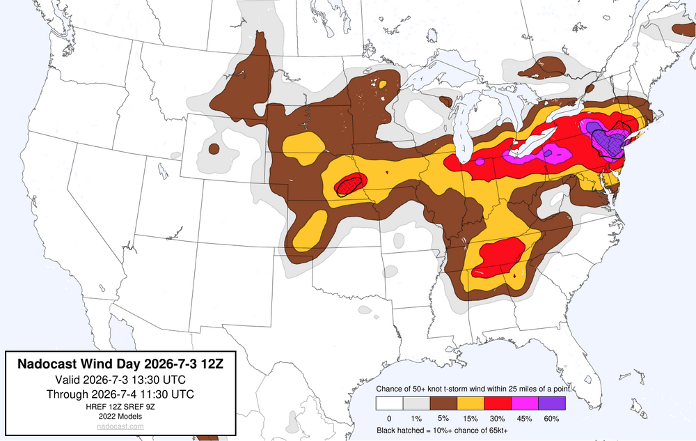
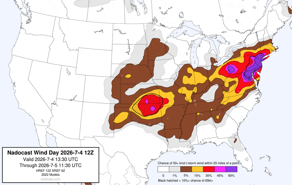
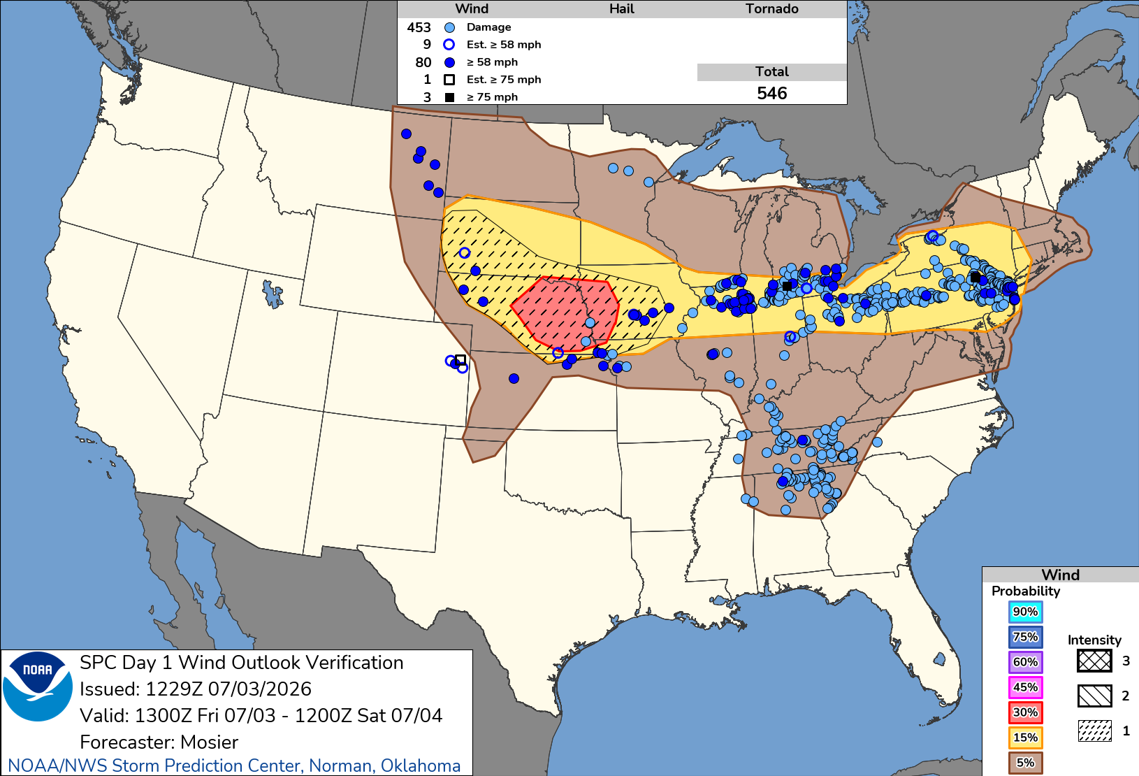
More severe wind gust potential with the storms later as the nadocast also did very well yesterday. data.nadocast.com/viewer.html Forecast for yesterday with the verification Forecast for today into tonight

-
Andddd the USAF fighters were nuts. Probably not going to see a concentrated air power demo before my time on this Earth runs out lol.
-
We were just in Leitersburg where we spent $25 to tickets and $45 in food and the beer wall to find out what the big disclosure from Disclosure day was. They have a little weather station at the theatre and it is a sweet 103. Car therm confirmed. The chickens are staying confined to under bushes and trees right now. I am glad this nonsense is coming to an end soon. Need rain badly.
-
RDU has hit 100F and it is likely that here now as clouds have cleared.
-
Agreed. Was mentioning this earlier. You can see that on the Naval Academy, BWI, Ft. Meade and PG mesonet sites. Looks like it's running right along I-97.
-
 Unbelievable
 -
 Two days ago they had low 90s here and for awhile I thought Monday had a shot not that was before all the clouds and shower chances started showing up
 -
Just received about 2" of rain in 20-30 minutes Sent from my SM-G991U using Tapatalk
-
The pictures (and shots on TV) from DC are just epic. What a celebration of our nation!
-
Hrrr seems to be pushing rain back to 4-6z hopefully it’s right
-
Hard to be 100% sure with all the ground clutter on radar, but looks like there’s a bay breeze boundary in southern AA and Calvert counties.
-
101/72/112 Was out briefly breeze makes it not feel quite as thick humidity wise.
-
Wow Inner Harbor (DMH) spikes to 104° Frederick (FDK) hits 100°
-
98/69
-
Impressive LSR for that warned cell which collapsed just to the southwest of Luray. Classic microburst:
-
101.5 again today. Still a bit of time to beat that before convection begins.
-
Picturized.
.thumb.gif.8c221d01c70bc323eab0359fffceafb1.gif)
-
AFSOC was even better.
-
Temp. dropped from 95 to 84 in a thundershower that dropped .07" rain.
-
Impressive 18z sounding from IAD: Surface CAPE of ~3,100 DCAPE of ~1,400 Lapse rage of -8.4°c/km Classic robust wet microburst sounding. One red flag for more widespread convection is the convective temp of 100° and a 700mb temp of almost 11°, which is still pretty capped. If we get shielded over with cirrus, then we might lose the oompf needed to get the more robust cluster and line segments going.
-

2026 Mid-Atlantic Severe Storm General Discussion
high risk replied to Kmlwx's topic in Mid Atlantic
Dew points have legitimately crashed. That doesn’t seem to be hindering storm development to the west, and irs probably increasing the wind threat (with larger downdraft cape), but it *might* limit coverage a bit.- 943 replies
-
- 2
-

-
- severe
- thunderstorms
- (and 7 more)
-
Fort Belvoir (DAA) and Lake Anna/Bumpass (7W4), and Fredericksburg (EZF) all hit 100°. We definitely seem to be running just a degree or two warmer today in the air temperature department.
-
 It is at 140kt (category 5) and expected to decrease to 130 kt and go up to 150 kt while being directly on track for the Northern Mariana Islands (USA)


.gif.242221a93707315a3de5ec5eb5ef08e1.gif)
