All Activity
- Past hour
-

September 2025 OBS-Discussion centered NYC subforum
psv88 replied to wdrag's topic in New York City Metro
82. Summer hanging on? -
Surprised the system right off NC isn't showing up on anyone's radar. It seems to be quite close to tropical storm level, with winds about 55 kph.
-
Inland for the big + departures
-
And it looks to screw the NW crew for the most part (possibly entirely). We could all use some rain drops.
-
Ravens beat the spread again. They are 2-0 vs the line this season. These are the same betting odds that currently has them tied for #1 super bowl favorite.
-
Just drove from Nags Head back through currituck. It's terrible. It was pouring on the beach. Then not so much through southern Currituck until north of Grandy and downhill again. Very gusty. Nasty. Feels damp but non tropical.
-
Please just hold the heavy/steady stuff off until AFTER 12:00 pm tomorrow in western Montgomery County.
-

2025 Atlantic Hurricane Season
WxWatcher007 replied to BarryStantonGBP's topic in Tropical Headquarters
Not tropical but plenty of impacts -

Fall 2025 Medium/Long Range Discussion
A-L-E-K replied to Chicago Storm's topic in Lakes/Ohio Valley
not seeing any end to the mild weather anytime soon -
And spread out over 24-48 hours. Not much consistency on when it’s raining for the metro areas.
-
This is an interesting take regarding AMO activity. The conclusion makes sense when you connect volcanic events during the inactive period timeframes. https://www.science.org/doi/10.1126/science.abc5810 Multidecadal climate oscillations during the past millennium driven by volcanic forcing
-
If we do in fact end up below 100 ACE, I think we need to seriously reconsider the 3 main factors the majority of people use for tropical seasonal forecasts…..ENSO state, MDR SSTs and the overall AMO state
-
Above average temps will couple with it. Nina is almost always warm/wet cold/dry.
-

September 2025 OBS-Discussion centered NYC subforum
anthonymm replied to wdrag's topic in New York City Metro
That pacific look is awful actually for the eastern US. The strongest warm anomalies are in the western pac. I think this is gonna reinforce western Aleutian ridging and troughing over the rockies. Should be a very familiar feeling winter for the I95, similar to the last few years with western storm tracks/great lakes cutters. - Today
-
Now that we're in CAM range, what really stands out to me is that this is going to me much more of a showery event than the rain shield I was expecting.
-
Congrats on the red tag!
-
Hatteras buoy is now reporting sustained 35 kt wind with gusts approaching 50 kts. Likely to be an unpleasant day on the obx
-
We're getting there... slowly... it at least appears better than last night's you posted.
-
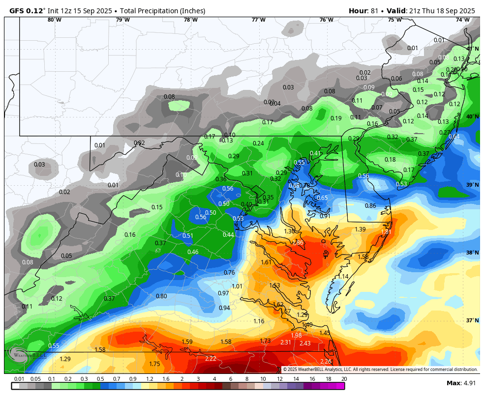
WB 12Z GFS for midweek.

-

September 2025 OBS-Discussion centered NYC subforum
Dark Star replied to wdrag's topic in New York City Metro
I guessing upwelling from the Hurricane that scooted off to our east about 2 weeks ago? -
If this indeed turns out to be this year's nadir, I find that interesting - it'd be the earliest of all recent seasons, regardless of magnitudes, whence the nadir took place

-

September 2025 OBS-Discussion centered NYC subforum
Brian5671 replied to wdrag's topic in New York City Metro
wonder what's causing that cold patch off our coast? -
So... As we start to see all the " Hype factor " for this upcoming Winter.... A new one just popped up. It's the CFS model and it shows very cold air for December, January, and February for much of the Central and Eastern US. I'm just not sure if that is a reliable model or not ( at least compared to the other Global models ).
-

September 2025 OBS-Discussion centered NYC subforum
SACRUS replied to wdrag's topic in New York City Metro
Latest SST anomaly -
boy is this weather boring.....and fantastic. Could definitely use some rain. trails and streams are bone dry.