All Activity
- Past hour
-
Records: Highs: EWR: 98 (2022) NYC: 96 (1939) LGA: 96 (1987) JFK: 94 (2022) Lows: EWR: 44 (1938) NYC: 46 (1938) LGA: 50 (2021) JFK: 48 (2023/2021) Historical: 1830: Shelbyville, Tennessee was turned into "a heap of ruins" as a tornado moved east through the center of the town. This tornado destroyed 15 homes and 38 businesses along with churches and other public buildings. Losses were estimated to be as high as $100,000. A book was said to be carried seven miles away. 1858: A tornado moved across Warren County and devastated the town of Ellison, IL about 14 miles southwest of Monmouth. Only 3 cabins were left standing. 19 people were killed, and 60 injured, along the tornado's 5 mile long track. (Ref. Wilson Wx. History) 1889 - The Johnstown disaster occurred, the worst flood tragedy in U.S. history. Heavy rains collapsed the South Fork Dam sending a thirty foot wall of water rushing down the already flooded Conemaugh Valley. The wall of water, traveling as fast as twenty-two feet per second, swept away all structures, objects and people. 2100 persons perished in the flood. (David Ludlum) 1927: Springtime of 1927 saw 18.64 inches of rain fall in the Peoria, IL area. This established their wettest Meteorological Spring (March, April, May period) on record. (Ref. Wilson Wx. History) 1934: Early season heat gripped central Illinois. Springfield reported its earliest triple-digit high temperature on record, with a temperature of 101°. (Ref. Wilson Wx. History) 1941 - Thunderstorms deluged Burlington KS with 12.59 inches of rain to establish a 24 hour rainfall record for the state. (The Weather Channel) 1954: Sioux Falls, SD recorded their latest snowfall on this date when a half inch was reported. (Ref. Wilson Wx. History) 1961 : Boston, MA suburbs experience a late freeze. (Ref. NOAA Boston Weather Events) 1983: Albany, NY experienced its wettest spring season in 109 years of records with 19.54 inches while Philadelphia, PA also had their wettest spring with 21.85 inches of precipitation. (Ref. Wilson Wx. History) 1985 - Severe thuunderstorms spawned forty-one tornadoes across the Lower Great Lakes Region and southeastern Ontario which killed 74 persons. (Storm Data) 1987 - Thunderstorms in New England produced wind gusts up to 90 mph at Worcester, MA, and Northboro, MA, and hail an inch and a half in diameter at Williston, VT. Unseasonably hot weather prevailed in the northeastern U.S. The afternoon high of 94 degrees at Portland, ME, was a record for the month of May. (Storm Data) (The National Weather Summary) 1988 - Hot and humid weather prevailed in the eastern U.S. Thirteen cities reported record high temperatures for the date. Cape Hatteras, NC, reported their first ninety degree day in May in 115 years of records. "Dust buster" thunderstorms in northwest Texas drenched Amarillo with more than three inches of rain. (The National Weather Summary) 1989 - Thunderstorms produced severe weather and torrential rains in northern Indiana, northern Ohio and southern Lower Michigan. Saint John IND was drenched with four inches of rain in two hours, and Woodland MI was deluged with two inches in twenty minutes. Pittsburgh PA reported a record 6.55 inches of rain for the month of May, with measurable rain reported on twenty-five days during the month. (The National Weather Summary) 1990 - Afternoon and evening thunderstorms developing along a warm front produced severe weather from northwest Texas to southeastern Louisiana. The thunderstorms spawned sixteen tornadoes, including thirteen in northwest Texas. One tornado hit the town of Spearman, TX, causing more than a million dollars damage, and seven other tornadoes were reported within twenty-five miles of Spearman. Thunderstorms over northwest Texas also produced baseball size hail at Monahans, and wind gusts to 80 mph at Paducah. (The National Weather Summary) (Storm Data) 1991: May record seven consecutive 90°+ days-- DC May's record high temperature 99°, low 78° are both all time highs for May. Norfolk, VA hit 100° setting a new all-time record high for the month of May and Philadelphia, PA hit 97° tying their May record high set the previous day. This was the warmest May on record in Washington, D.C. The city also observed a record 11 days of 90-degree heat. (Ref. Wilson Wx. History) 1997: Mount Washington, NH recorded 95.8 inches of snow for the month which exceeded the previous May snowfall record by 43.6 inches. (Ref. Wilson Wx. History) 2013: The 2nd of the top 10 weather events for 2013 was EL Reno, Oklahoma tornado of May 31, 2013. Part of the multi-day storm outbreak caused $2 billion in damage. The EF3 that traveled through the western suburbs of Oklahoma City was the largest tornado ever observed with a width of 2.6 miles. It took eight lives including four tornado chasers.
-
.02" yesterday from an NWS predicted 1.00" - 2.00". 5.42" total for May. Normal 3.60". First above normal month since last September.
-
I think it’s gypsies down there. That area was in a bad drought for years
-
0.62 for the storm, 6.50” for May. Very wet month
-
Yeah even less here, just under .2" Suns bursting out, should outperform the mid 60s forecast for today. And should dry out a bit for you
-
Just over an inch here. Definitely some winners and losers with this one. Think I landed pretty much in the middle.
-
60 / 54 cloudy and windy gusts to 27. Some breaks in clouds now should start to become bigger breaks later but still more clouds than sun much of the day till later this PM. Upper 60s / Low 70s beyond the overnight highs. 0.82 in the bucket here. Clears out tomorrow starting off cool low 70s , stepping up warm Monday clear sunny - low - mid 70s, Muchar warmer Tue - clear and low 80s / mid 80s in the warmer spits. Wed - Fri - warmer areas first 90/low 90s other wise mid - upper 80s. Perhaps next shot at rain is Friday night / Saturday with weak fontal system. Overall warm to hot the 6/5 - beyond, the tenedncy for the onshore flow seems less than past ridge expansion coming up.
-
As am I. Curious too if we have a late summer and into fall heat push, so maybe higher departures then.
-
Lots and lots of power outages around here. Those strings winds must’ve done a number on tree branches.
-
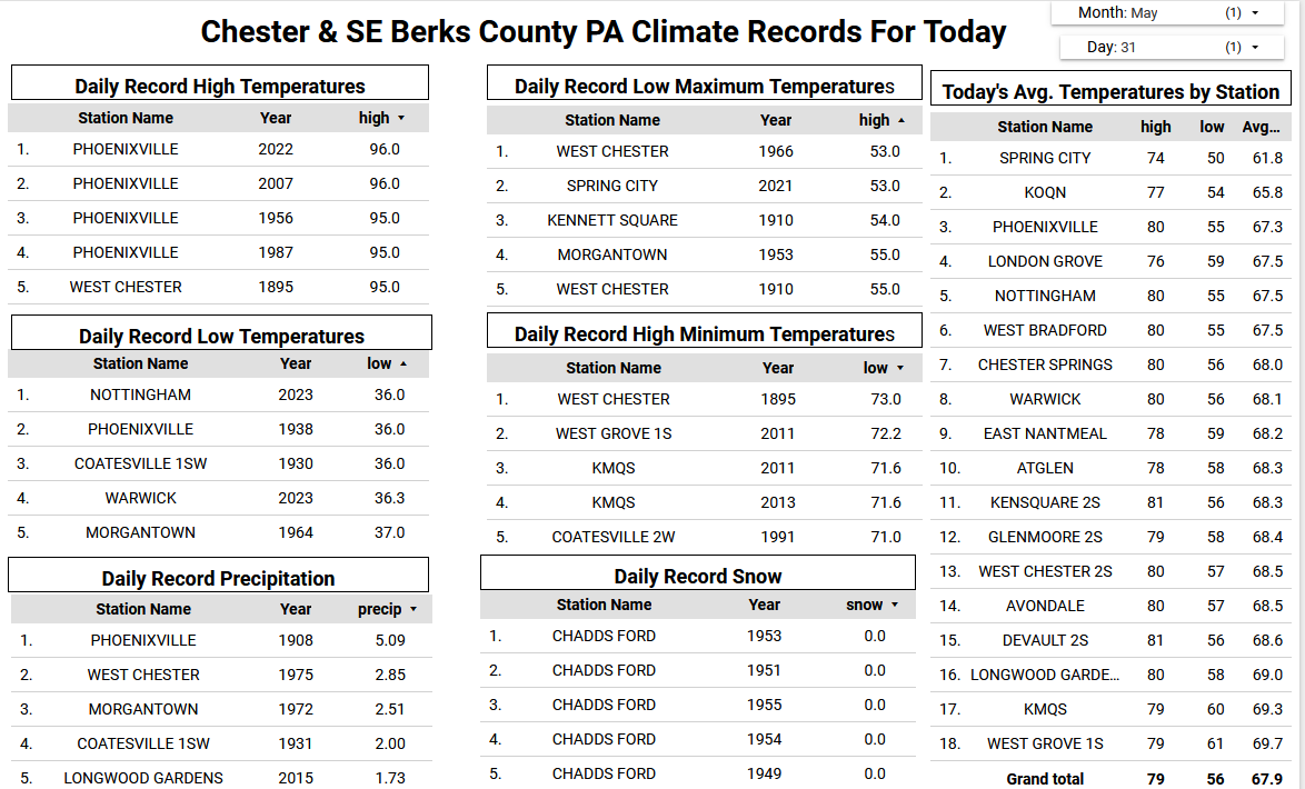
It looks like rainfall across the area ranged from as little as 0.48" at Atglen to as much as 1.51" at Devault. One more round of showers may cross the area late this afternoon and early evening with a strong cold front. We finally clear up tomorrow and begin a stretch of our best weather so far this spring. Most spots except the higher ridges should reach 80 degrees by Tuesday with low to mid 80's for all by Thursday.

-

E PA/NJ/DE Spring 2025 Obs/Discussion
ChescoWx replied to PhiEaglesfan712's topic in Philadelphia Region
It looks like rainfall across the area ranged from as little as 0.48" at Atglen to as much as 1.51" at Devault. One more round of showers may cross the area late this afternoon and early evening with a strong cold front. We finally clear up tomorrow and begin a stretch of our best weather so far this spring. Most spots except the higher ridges should reach 80 degrees by Tuesday with low to mid 80's for all by Thursday.
-
1.62 last 24 hours, 1.3 came in about 30 minutes yesterday. Fun facts from the my weather station. May 2025 had 2526 minutes of rain, or roughly 42 hours with 7.02” October 2024 had 32 minutes of rain with .06” of rain.
-
 DCA _ NYC _ BOS ___ ORD _ ATL _ IAH ___ DEN _ PHX _ SEA 1.6 2.2 2.3 2.6 0.2 0.8 0.4 1.3 0.5
 -
Not really a bust since the heavy rain was always going to be NW of our area. This was always going to be an under 1 inch storm for us. The sun coming out so early was a bit of a surprise, but it's awesome to have it most of the day. This is no *lull* either (I don't know why TV Mets use this stupid word, they're like robots), we're not going to be getting anything else today.
-
I knew it was going to bust. Had the feeling for days
-
1.3” for the event. Officially the wettest May in Harrisburg history.
-
Canada needs to change their flag from this, to this


-
Could add a little today with scattered showers/storms in the forecast.
-
5.2" for the month per my station. That's a little more than average for May.
-
The sun is in and out of the clouds overall it looks like a mostly rain free weekend for us.
-
Some heavy rain overnight. 4.41" for the day. Up to 12.51" for the month
-

2025 Lawns & Gardens Thread. Making Lawns Great Again
dendrite replied to Damage In Tolland's topic in New England
@Damage In Tolland
-
"last winter was cold"
-
partly sunny here after .56 of rain last nigh
-
Stats from Carlisle... Rainfall yesterday was 0.67". Overnight I recorded 0.11" for an event total of 0.78". Tentative total precip for May is 8.81" and YTD is 15.31". Low this morning was 54.7. Very low pressure for the end of May. My pressure bottomed out at 29.38" early this morning. The cold front has not reached us yet as the pressure has been steady all night, right around 29.41".