All Activity
- Past hour
-
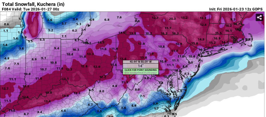
We are certainly rooting for the GFS in our necks, it’s how this can produce close to memorable #’s for us. 15+ is not out of the question with a few minor changes overall.
-

Pittsburgh/Western PA WINTER ‘25/‘26
colonel717 replied to Burghblizz's topic in Upstate New York/Pennsylvania
AIGFS has trended to squash total on north end over last 3 runs, but we remain unchanged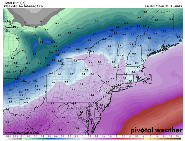
-
First time all week it's had a friendlier run, lol
-
-

Possible Record Breaking Cold + Snow Sunday 1/25 - Tuesday 1/27
Northof78 replied to TriPol's topic in New York City Metro
3 improved, 2 neutral, overall big south/stronger confluence trend -
CMC definitely improved over 00z
-

Central PA Winter 25/26 Discussion and Obs
canderson replied to MAG5035's topic in Upstate New York/Pennsylvania
GFS is a bulldog with this storm -

“Cory’s in LA! Let’s MECS!” Jan. 24-26 Disco
SeanInWayland replied to TheSnowman's topic in New England
This has been hashed out endlessly in football forums far and wide. It apparently takes about 1 1/2 weeks until the acclimation process kicks in to the point you are better off. Short of that, you are best off getting there the day before. -

January 2026 regional war/obs/disco thread
Torch Tiger replied to Baroclinic Zone's topic in New England
Pd2 sucked jmo, and this weekends is not much different. Everyone knows I like powerful storms and that ain't it. Hopeful the next is -

1/24-1/25 Major Winter Storm - S. IL, IN, MI and OH
Brian D replied to A-L-E-K's topic in Lakes/Ohio Valley
My Dr. told me once that N folks are a hearty bunch. Our bodies are tuned to rapid changes, so we adjust quickly. After this cold, 30 will feel like t-shirt wx. While 30 in the Fall warrants a winter coat. -

January 24-26: Miracle or Mirage JV/Banter Thread!
EHoffman replied to SnowenOutThere's topic in Mid Atlantic
Maybe I'll get...just a little rimey. -
Canadian and Reggie both have weird mini max and mins.
-
 A bit drier I think more than even warm, I don't see any 18+ totals anywhere on the GGEM.
 -
Not really. It is definitely a touch warmer up top this run. But its been pretty damn consistent.
-
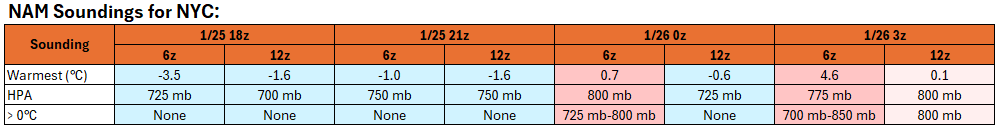
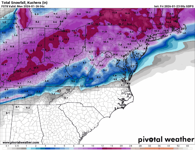
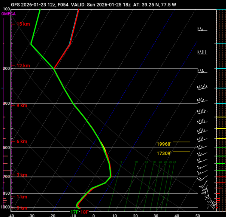
 The NBM's average snow-liquid ratio was down to 10.0:1 for the 1/23 12z output vs. 16.5:1 for the 1/23 0z output. In short, it was starting to come in line with what is typical for high QPF snow events. Given the warming that is expected at 650 mb-800 mb, which will change the precipitation to sleet in New York City and its nearby suburbs and south and east from there, I suspect that a storm average 7:1 to 9:1 is probably more likely. That will still translate into a significant snowfall for the New York City area. Initially, little has changed regarding the DGZ and vertical profile of temperatures during the onset to the height of the storm. Conditions are forecast to be almost ideal for dendritic formation. Hence, snow-liquid ratios will probably start at 13:1 to 15:1 and then fall as the mid-levels begin to warm prior to the change to sleet. Snowfall rates could approach 1"-2" per hour during late Sunday morning into the early Sunday afternoon as an area of powerful 700 mb frontogenic forcing moves across the region. The NAM had been the most aggressive model with the push of warm air aloft at 6z, but it backed off at 12z, due to a combination of a weaker/more southward primary low and overall reduction in amplification at 500 mb. The RGEM had moved in a similar direction as the 12z NAM during the 6z cycle but then reversed itself at 12z. A comparison of the 6z and 12z NAM soundings for NYC for select points in time is below. With the models continuing to shift about, it makes little sense to pursue hunches or preconceived notions into blind alleys, throw darts to guess which specific model solution will verify, or to ride any single model and the roller coaster of emotions it brings with each cycle. Thus, continuity at this point is a better approach than lurching in one direction or another only to crash one's forecast. To me, it still appears that New York City and nearby areas will likely see a storm total of 6"-12" of snow and sleet. Areas to the south and east of New York City could see 4"-8" amounts. Pockets of 12"-18" amounts are possible well north and west of New York City, most likely in parts of northeastern Pennsylvania, Orange County, Dutchess County, and Sussex County. There remains some uncertainty concerning mid-level and surface storm evolution and tracks, and perhaps somewhat greater uncertainty regarding a potential primary-secondary storm handoff. Model skill is improving and will improve markedly today as the lead time shortens during the day. For now, it appears that the models are slowly working toward a consensus. At present, there's no compelling need to make changes up or down in storm total snow/sleet amounts.
-
 Canadian looks 8-12 verbatim
 -

January 24-26: Miracle or Mirage JV/Banter Thread!
H2O replied to SnowenOutThere's topic in Mid Atlantic
I doubt Fx Co go at all next week with only 3 days and then 2 teacher workdays -

Possible Record Breaking Cold + Snow Sunday 1/25 - Tuesday 1/27
EastonSN+ replied to TriPol's topic in New York City Metro
Update. Improved: NAM CMC RGEM Did not improve: ICON GFS Waffles. -
this is near Leesburg
-
GGEM QPF kinda looks like that rufus run
-

January 24-26: Miracle or Mirage JV/Banter Thread!
North Balti Zen replied to SnowenOutThere's topic in Mid Atlantic
My comment , fwiw, was aimed at the main thread freakouts…freakouts in here are acceptable lol -

Possible Record Breaking Cold + Snow Sunday 1/25 - Tuesday 1/27
NJwx85 replied to TriPol's topic in New York City Metro
It’s a bit less than the GFS but not terrible. -
GGEM is a beatdown for a lot of folks here. 8+ for metro areas thanks to a big thump. Bit colder as well.
-

Possible Record Breaking Cold + Snow Sunday 1/25 - Tuesday 1/27
lee59 replied to TriPol's topic in New York City Metro
This should be a good nowcast storm. So many variables. Long Island looks to be good up front snows, then sleet or freezing rain and back to snow. -
Pittsburgh/Western PA WINTER ‘25/‘26
colonel717 replied to Burghblizz's topic in Upstate New York/Pennsylvania