All Activity
- Past hour
-

11/8-11/10 First Snow and Lake Effect Event
donsutherland1 replied to Geoboy645's topic in Lakes/Ohio Valley
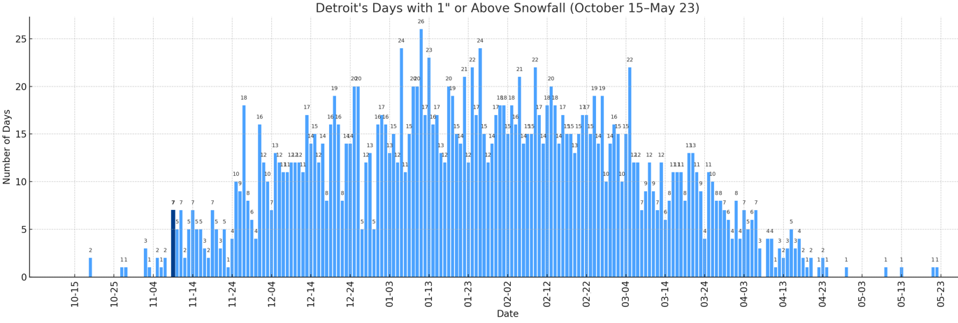
With 1.2" of snow earlier today, Detroit saw 1" or more snowfall for the 7th time on record for November 9. November 9 is the earliest date with 7 or more such snowfalls.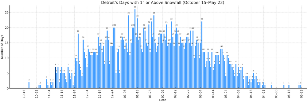
-
@CAPE enjoying this ravens O line performance?
-

November 2025 general discussions and probable topic derailings ...
Brewbeer replied to Typhoon Tip's topic in New England
Just pointing out the hypocrisy, carry on Sprinkling here in Bridgeport, about to ferry over to LI -
I just signed into YouTube tv and am doing a 20 minute free preview of NFL Sunday Ticket just to see some snow falling.
-
11/8-11/10 First Snow and Lake Effect Event
Paulie21 replied to Geoboy645's topic in Lakes/Ohio Valley
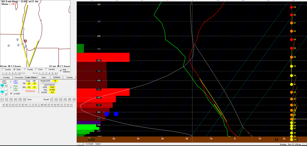
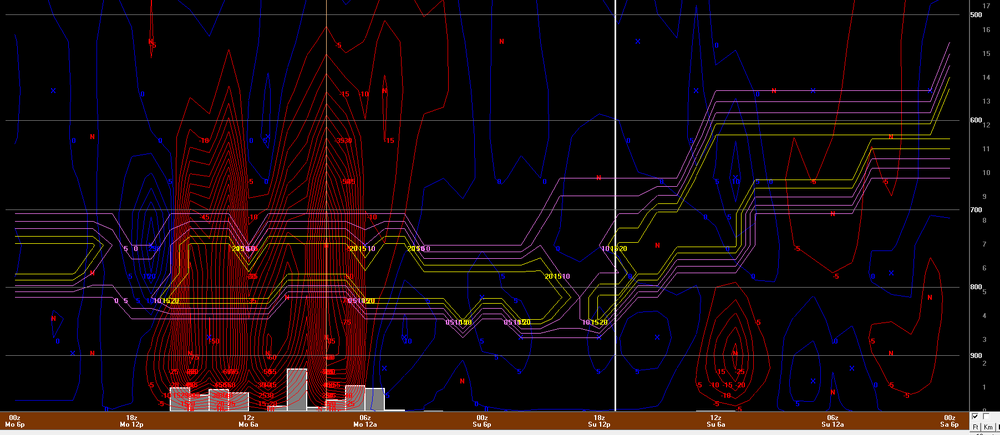
Airmass tonight into tomorrow features H5 temps from -39C to -41C approximately and H85 temps at around -10C. Meanwhile lake temps are in the low 50s, I'm using 51 so using 11C. Pretty impressive lapse rates and given EL levels are approaching 25kft the lake induced CAPE may be near 1500 J/kg on the new HRRR. Values overall are 'extreme' for a few hours for KCGX and LM3 per bufkit. Seems like a fairly decent fetch along the lake, included 925mb RH% and streamlines as a visual. Pretty tremendous omega values co-located with the DGZ will only add the big flakes/aggregates, also seen on the overview image. Likely not as noteworthy given we already have plenty of lake induced CAPE but liking the theta-e contours in the vertical for some weak symmetric stability. Some limiting factors may be subtle low level inversions at times along with moisture depth/saturation throughout the layer. Think another issue may be a bit of directional shear at times will wobble the band enough to limit those high accumulations in a single area.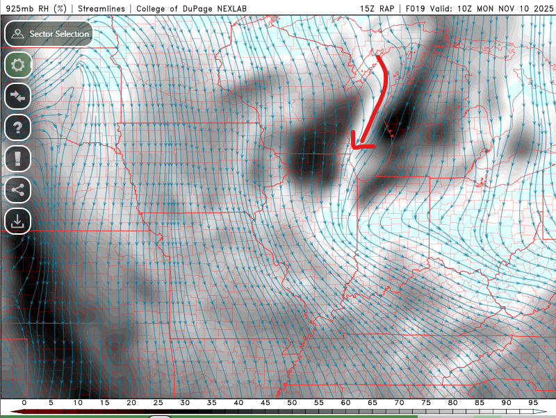
-

11/8-11/10 First Snow and Lake Effect Event
Chinook replied to Geoboy645's topic in Lakes/Ohio Valley
The changeover from rain to snow produced some heavier snowfall rates here in Toledo. I believe my place got over 2" before 10:00, and we still have snowflakes and 35 degrees. -
Euro next Monday
.thumb.png.95ee14267e3d8cab5020836bb004406f.png)
-

November 2025 general discussions and probable topic derailings ...
WinterWolf replied to Typhoon Tip's topic in New England
Lol..silly stuff. Clickbait wording. -

11/8-11/10 First Snow and Lake Effect Event
mimillman replied to Geoboy645's topic in Lakes/Ohio Valley
Pretty nuts if this pans out Tonight Snow showers, mainly after 9pm. The snow could be heavy at times. Some thunder is also possible. Low around 28. Blustery, with a north wind around 20 mph, with gusts as high as 30 mph. Chance of precipitation is 90%. New snow accumulation of 11 to 17 inches possible. Monday Snow showers likely, mainly before 9am. The snow could be heavy at times. Some thunder is also possible. Mostly sunny, with a high near 36. West northwest wind around 15 mph, with gusts as high as 25 mph. Chance of precipitation is 70%. New snow accumulation of 2 to 4 inches possible. -
Can you ever just enjoy BN? The jet is too strong, Cold to our north. Raging pacific. The cold is too deep, cold to our south. If we listened to you last week, it would be approaching 70 mid month. I find your posts very informative, but with an endless warmth the world is ending agenda. You undermine your own intelligence with it (and you are intelligent)
-

November 2025 general discussions and probable topic derailings ...
Ginx snewx replied to Typhoon Tip's topic in New England
Snow football Bears Giants -
Congratulations on the new job.
-

Central PA Fall Discussions and Obs
Blizzard of 93 replied to ChescoWx's topic in Upstate New York/Pennsylvania
Lake event, their Warning is impressive. Winter Storm Warning URGENT - WINTER WEATHER MESSAGE National Weather Service Chicago IL 1121 AM CST Sun Nov 9 2025 ILZ103>105-108-100330- /O.CON.KLOT.WS.W.0001.251110T0300Z-251110T1800Z/ Northern Cook-Central Cook-Southern Cook-Eastern Will- Including the cities of Oak Lawn, Park Forest, Beecher, Orland Park, Cicero, Northbrook, Schaumburg, Crete, Lemont, Palatine, Evanston, Oak Park, Calumet City, Oak Forest, Des Plaines, La Grange, Peotone, and Chicago 1121 AM CST Sun Nov 9 2025 ...WINTER STORM WARNING REMAINS IN EFFECT FROM 9 PM THIS EVENING TO NOON CST MONDAY... * WHAT...Dangerous to impossible travel conditions due to intense lake effect snow expected. Snow rates in excess of 3 inches per hour, localized total snow accumulations of 12 to 18 inches, and northerly wind gusts in excess of 30 mph are expected. * WHERE...Central Cook, Eastern Will, Northern Cook, and Southern Cook Counties. * WHEN...From 9 PM this evening to noon CST Monday. * IMPACTS...Snow rates in excess of 3 inches per hour will cripple travel, including during the Monday morning commute. Strong northerly wind gusts in excess of 30 mph will lead to greatly reduced visibility, especially near the Lake Michigan shoreline. Periods of thundersnow will occur, as well. * ADDITIONAL DETAILS...Lake effect snow is often very localized, with conditions varying from safe to dangerous across just a few miles. Snow totals in the Winter Storm Warning area may vary considerably from one location to the next. -
11/8-11/10 First Snow and Lake Effect Event
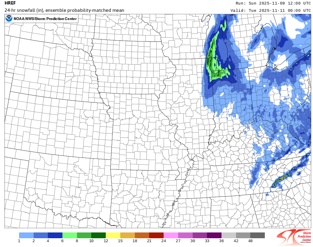
donsutherland1 replied to Geoboy645's topic in Lakes/Ohio Valley
The 12z HREF:
-

November 2025 general discussions and probable topic derailings ...
Cobalt replied to Typhoon Tip's topic in New England
Ryan Maue purposefully uses language like this to generate reactions on social media, particularly from people who use such tweets as examples of anthro climate change proponents being "extremists" or "doomists". It's funny, because beneath that veil he likely is more aligned with the people who get reactionary when he uses such phrases as "climate breakdown". He served as the chief scientist at NOAA under Trump, and at the time was known for minimizing humanity's role in recent climate trends. Maybe that implies that there's a good bit of sarcasm in that tweet's wording, but it is not the first time he's done such a thing. - Today
-
The official Chicago records have been at O’Hare since 1980 and were at Midway 1942-79. Prior to that they were even closer to the lake. Keeping this in mind: the official Chicago record heaviest Nov snowfall for a single storm is 12.0” (11/25-6 of 1895). That was from a strong low (rather than pure Lake Effect) that moved from N Miss to E of MI per old wx maps. Like @donsutherland1said, it’s highly unlikely this will even be close to 12” officially. (I saw that he mentioned that 4”+ is reachable though).THE FOLLOWING IS THE UPDATED LIST OF THE LARGEST SNOW EVENTSDURING THE MONTH OF NOVEMBER FOR CHICAGO DURING THE PERIOD OFRECORD...WHICH IS SINCE 1884:RANK DATES EVENT SNOWFALL /IN/-----------------------------------------1. NOV 25-26 1895 12.02. NOV 20-21 2015 11.23. NOV 6-7 1951 9.34. NOV 26-27 1975 8.6 5. NOV 27-28 1891 6.0RANK MONTH MONTHLY SNOWFALL /IN/-----------------------------------------1. NOV 1940 14.82. NOV 1895 14.53. NOV 1951 14.34. NOV 2015* 11.25. NOV 1975 10.8 https://www.weather.gov/lot/earliestnovsnows
-
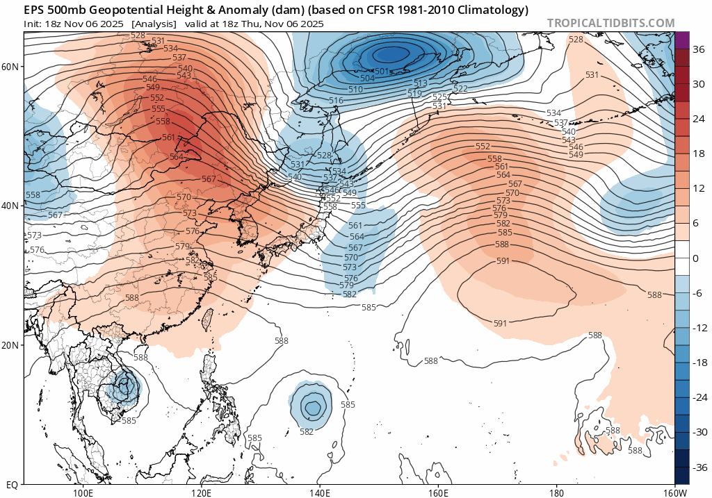
My thinking is later on there will be a phoon headed towards China the next couple days,this will pump up the heights from the Yellow Sea into Japan along with the MJO headed into the WP,so that should be height rises towards Mid Nove for a few days,guess the good news right now is the MJO could possibly go into the COD,but anyways what the EPS seems to be showing today is a trough going thru East Asia round the 15th,so we'd probably be seeing a CF right before thanksgiving and back to BN temps at least for a bit..JMO

-

November 2025 general discussions and probable topic derailings ...
tavwtby replied to Typhoon Tip's topic in New England
climate breakdown? sounds like a great time to me, and granted a little early in the season, but climate breakdown??? i need explanation. -

Central PA Fall Discussions and Obs
Superstorm replied to ChescoWx's topic in Upstate New York/Pennsylvania
Is it lake enhanced? . -
 It's nearly to the western coast of Luzon at this point, for the center on the IR satellite.
 -

Fall 2025 WX Discussion Thread
Holston_River_Rambler replied to Carvers Gap's topic in Tennessee Valley
RAP and HRRR give us a radar presentation like a little cyclone tomorrow. I wonder if that will verify? -
 They rip
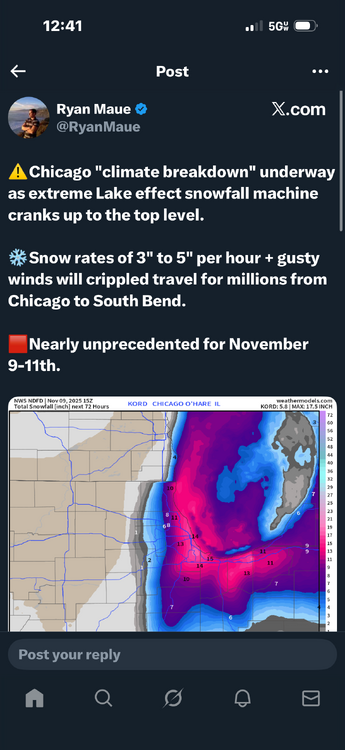
-
 Fung-Wong just made landfall in central Luzon as a 115-mph typhoon, very large storm too. It’s forecast to move across Luzon at a good clip, so hopefully doesn’t cause too many flooding problems.
 -

November 2025 general discussions and probable topic derailings ...
Snowedin replied to Typhoon Tip's topic in New England
Sending good vibes and torches to the homies back home. Let’s keep that southerly flow going!
-

11/8-11/10 First Snow and Lake Effect Event
KeenerWx replied to Geoboy645's topic in Lakes/Ohio Valley
Took a tour through some cams across Porter County. Looks like perhaps a RA/SN mix along the 94 corridor. But down towards Valparaiso, snowing heavy & accumulating nicely.


.png.e4cd31edb4f067def5392e8a70fe12a0.png)