Paulie21
-
Posts
68 -
Joined
-
Last visited
About Paulie21

- Birthday 03/19/1994
Recent Profile Visitors
2,617 profile views


-
Dec 6-7th (It's not a clipper) Clipper
Paulie21 replied to Chicago Storm's topic in Lakes/Ohio Valley
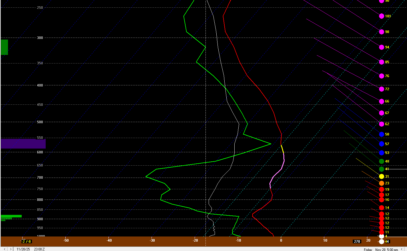
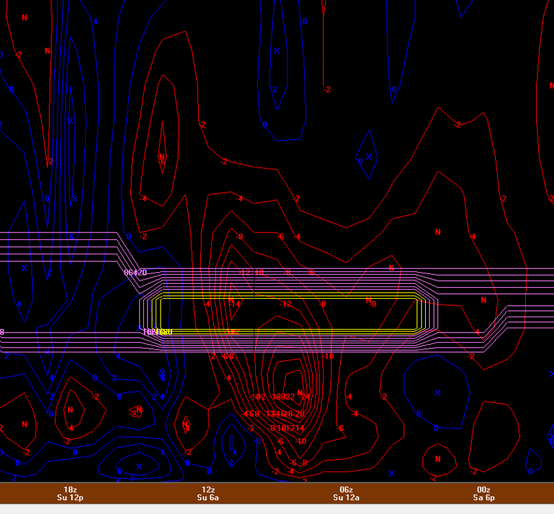
Pretty much all models hinting at a nice corridor of higher UVVs for northern IL tonight between 850mb - 750mb. Not perfectly co-located with the small area of DGZ but not bad at all for a couple hours of 1"+/hr rates perhaps. Not perfectly textbook case but looks like theta-e lines in the cross section are more spaced out and climbing. Perhaps some slantwise convection possible? Not a perfect setup but it does coincide with best LRs (saturated) in the sounding, strong speed shear above veering wind profile, AND weak absolute vorticity. Could really thump right before dawn.
- 97 replies
-
- 11
-

-

-
Nov 28-30th Post Turkey Day Winter Storm
Paulie21 replied to Chicago Storm's topic in Lakes/Ohio Valley
I think 8-10” is fair forecast. Thinking 16 hours + of snow. Averaging 1/2” per hour ish. Wherever this enhanced H5 band of UVV's lands will definitely have some higher rates/bigger flakes, liking I-88 to I-90 corridor (for now). Wouldn't rule out some stray TSSN in this weenie band.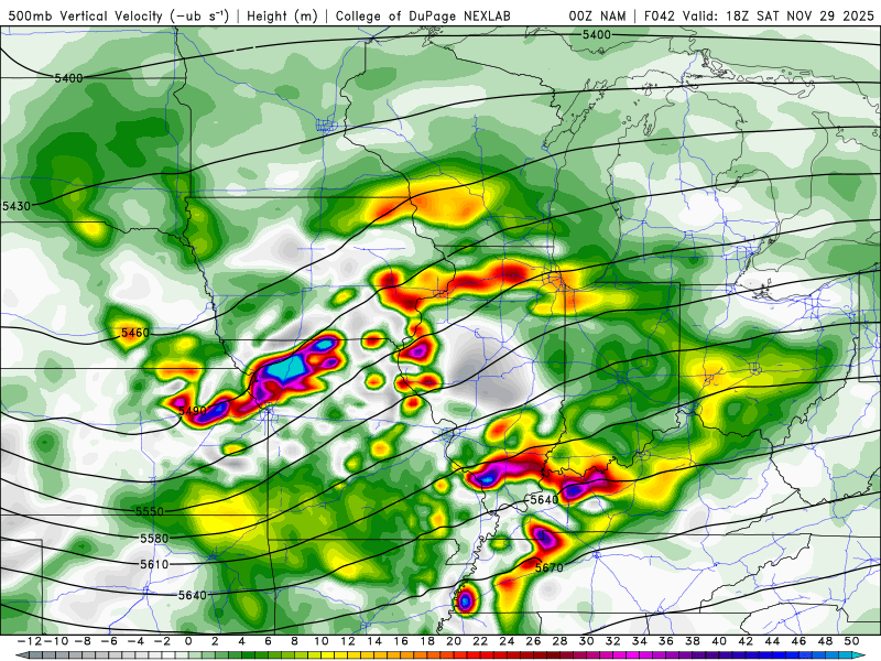
-
Nov 28-30th Post Turkey Day Winter Storm
Paulie21 replied to Chicago Storm's topic in Lakes/Ohio Valley
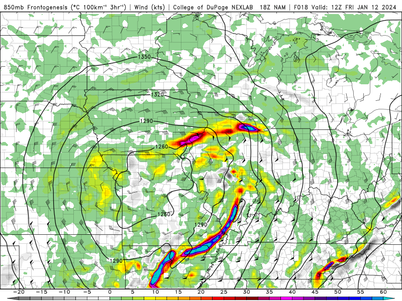
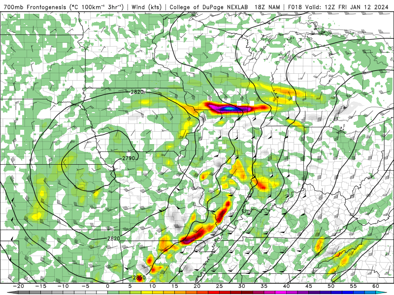
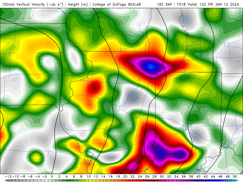
Hope the GIF works.. 18z NAM for ORD here. Pretty decent co-location between Omega and DGZ. Fairly shallow DGZ sitting at 100-150mb depth; and though best omega is a bit above, still not too bad. There's also some slight jet coupling perhaps earlier in the event. Tough to tell the ratios between WAA snow, decent dynamics, but also at worst some precip mixing. Personally think KLOT is a bit lambish but it is tough to tell for now. We'll have a better idea with high res models of course. Hoping we can squeeze a brief weenie band somewhere midday in nIL.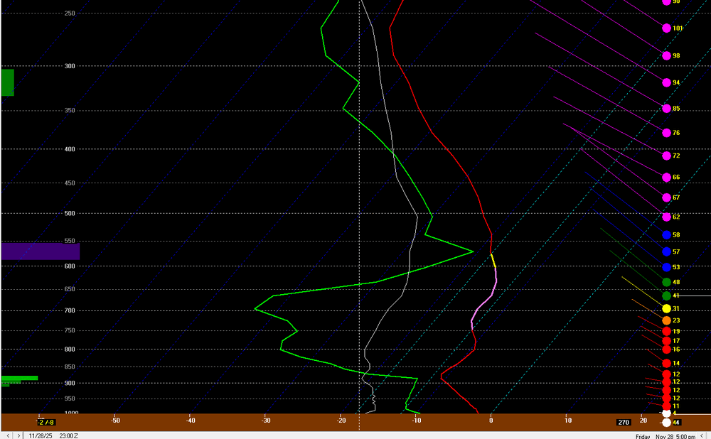
-
11/8-11/10 First Snow and Lake Effect Event
Paulie21 replied to Geoboy645's topic in Lakes/Ohio Valley
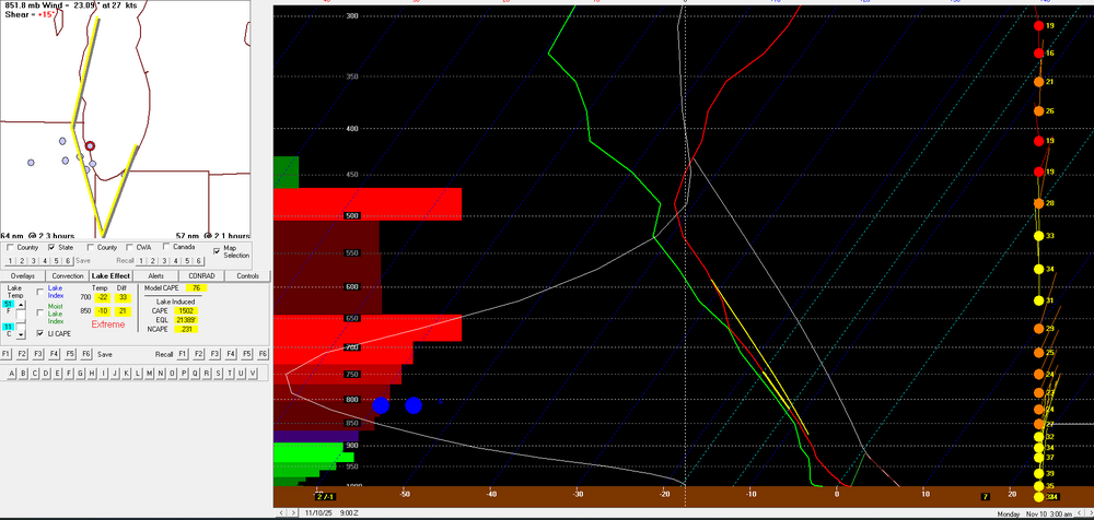
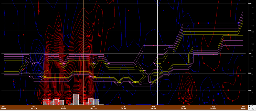
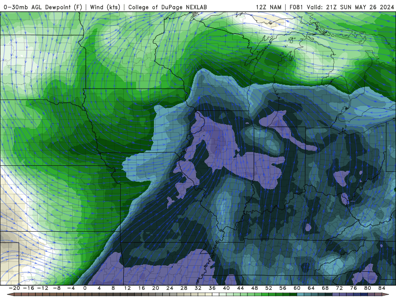
Airmass tonight into tomorrow features H5 temps from -39C to -41C approximately and H85 temps at around -10C. Meanwhile lake temps are in the low 50s, I'm using 51 so using 11C. Pretty impressive lapse rates and given EL levels are approaching 25kft the lake induced CAPE may be near 1500 J/kg on the new HRRR. Values overall are 'extreme' for a few hours for KCGX and LM3 per bufkit. Seems like a fairly decent fetch along the lake, included 925mb RH% and streamlines as a visual. Pretty tremendous omega values co-located with the DGZ will only add the big flakes/aggregates, also seen on the overview image. Likely not as noteworthy given we already have plenty of lake induced CAPE but liking the theta-e contours in the vertical for some weak symmetric stability. Some limiting factors may be subtle low level inversions at times along with moisture depth/saturation throughout the layer. Think another issue may be a bit of directional shear at times will wobble the band enough to limit those high accumulations in a single area.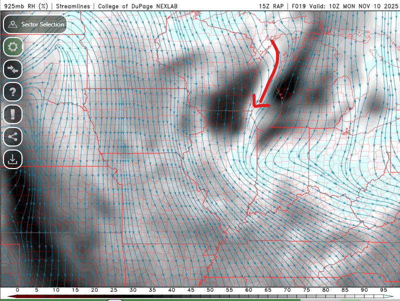
- 213 replies
-
- 11
-
-
-
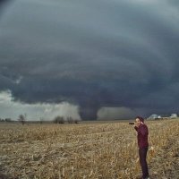
It's got that look honestly.
-
2024 Short/Medium Range Severe Weather Discussion
Paulie21 replied to Chicago Storm's topic in Lakes/Ohio Valley
End of NAM hype but Sunday is looking more and more interesting. Has already looked pretty solid on globals the last couple of days too.
-
Did Someone Say Clipper(Hybrid)!?! 1/18-1/19
Paulie21 replied to Frog Town's topic in Lakes/Ohio Valley
Yeah the LE looks almost textbook. Crazy long fetch with steady 600+ lake induced CAPE for hours. Could definitely see 3"+/hr rates in that at times. -
Sitting just shy of 6" in West Dundee. Had some pingers mixing in for a couple hours, back to all snow. Flakes slowly improving here
-
Yeah NIU coop obs at 7am got 6.0 with 0.61 liquid equivalent.
-
Weenie band in full force on the NAM.
-
Fun morning commute brought to you by the new RAP
-
There's a good consensus on the morning stuff really ripping across NE IL at ~12Z Very strong lift nearly maxing out in the shallow DGZ and then some. Steep lapse rates above 700mb with a hint of some frontogenetic banding. Truly cannot rule out some TSSN in this weenie band. Gonna be snow globing right in time for morning commute. Edit: Also, just looked at bufkit, some near 0 EPV in a large portion of this column for a couple hours.
-
Good snippet from Gino regarding these aggregates: "the recipe for the HUGE aggregates like that is deep ascent throughout the column, through a wide temp range to get a variety of flake types and then the key is a deep isothermal layer near or just below 0C where the snow is wet and prone to clumping. This is about as perfect of a set-up for that as you'll see"
-
Yeah these ratios are definitely a buzzkill. DGZ is rather shallow and most of the time the omega is nothing to write home about either. Here's 12Z HRRR for KDPA. Wouldn't be surprised if front end WAA thump over performs a bit, but overall liking midday Tuesday for NW/W burbs. Liking my chances here in West Dundee. Although UVV's aren't a bullseye, it's much more promising the prior hours. Additionally, liking the theta-e during that time too for some weak symmetric stability, although the lack of fgen banding might inhibit the potential. Either way, it wants to puke out over an inch of concrete in an hour during lunch time.
-
Another promising GFS run on the 12Z, slight bump north, wetter, bit of a stronger low. A bit far out still but nice to see favorable UVV's increase from previous runs.