

wegoweather
-
Posts
136 -
Joined
-
Last visited
About wegoweather

Recent Profile Visitors
2,275 profile views


-
Have had some interesting interactions with weather "technology" this week at high school sporting events. Monday night the school we were at had a Thor Guard system still turned on while their new Perry Weather system was also active. The Perry Weather alarm cleared the stadium about 8 minutes before the Thor Guard sounded. 30 minutes later the Thor Guard sounded the all clear while the Perry Weather system had reset it's 30 minute delay twice and still had around 20 minutes to go. The Thor Guard never sounded again, but the Perry system reset it's 30 minute clock 2 more times. Total delay was over 70 minutes and there were two visible CC lighting flashes which didn't set off the Thor or reset the Perry. Last night at another school there was visible CC lightning in the distance. The referees wanted to clear the field but the school's AD was on site and said their warning system indicated the game could continue. Lightning continues west and north of the stadium. Then a CC lightning just east of the stadium flashes. Referees clear the field, and the school's warning system never sounded. While I agree about the "crying wolf", the risk associated with not warning can be high.
-

Winter 2025-26 Medium/Long Range Discussion
wegoweather replied to michsnowfreak's topic in Lakes/Ohio Valley
I can already hear the CBus people talking about how they got cheated out of 57 inches of snow. -
Winter 2025-26 Short Range Discussion
wegoweather replied to SchaumburgStormer's topic in Lakes/Ohio Valley

-
Nov 28-30th Post Turkey Day Winter Storm
wegoweather replied to Chicago Storm's topic in Lakes/Ohio Valley
-
Nov 28-30th Post Turkey Day Winter Storm
wegoweather replied to Chicago Storm's topic in Lakes/Ohio Valley
Winter Storm Warning up for LOT, MKX, ILX. -
Nov 28-30th Post Turkey Day Winter Storm
wegoweather replied to Chicago Storm's topic in Lakes/Ohio Valley
Yes x 4 -
March 14-15 Severe Weather Outbreak
wegoweather replied to MazooWeather's topic in Lakes/Ohio Valley
Looks like they went to update the Tor Warning to say the threat had moved on and the warning would expire at 12:15, and someone took it as a new Tor Warning for all of DuPage and Kendall county. -
Winter 2024-25 Medium/Long Range Discussion
wegoweather replied to michsnowfreak's topic in Lakes/Ohio Valley
The video titled "Will we have a winter" and talks about warm moderation between the 10th through the 25th or 30th with potential for a favorable winter pattern returning early January? I get the jealousy from those whose following ends at anonymous posts on a bad facebook page and this website, but this thread is titled "Medium / Long Range Discussion". Wiithout BAM type posts all we have are zzzz with 384 Hr 2m surface temp screenshots and "Torch Incoming" posts. -
Flipped back to snow at KDPA. We'll see what we get out of the last couple of hours.
-
Haven't gone back to look but I seem to remember some of the CAMs generally modeling where we sit currently (at least in the LOT CWA).
-
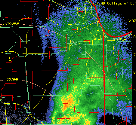
Looks like you can see it from ILX Radar.
-
With the amount of snow and the low ratios, compaction is going to really factor in. Would be interesting if someone had the time to run two snowboards and do an aggregate hourly and storm total measurements.
-
Small error in the LOT WSW text in regards to the counties.
-
Pavement accumulations have started again at KDPA. 1.5" slush storm total so far.
-
NAM back NW a bit and a little wamer for Chicago metro.


