All Activity
- Past hour
-

11/8-11/10 First Snow and Lake Effect Event
Powerball replied to Geoboy645's topic in Lakes/Ohio Valley
I miss the Snow Advisory and Heavy Snow Warning headlines too... -

11/8-11/10 First Snow and Lake Effect Event
sbnwx85 replied to Geoboy645's topic in Lakes/Ohio Valley
Vort max is coming ashore now. Band should shift towards Illinois. Strong meso low and a Lake Huron connection creating decent snows across Western Michigan. That should come south and keep the snow falling off and on until about midnight locally.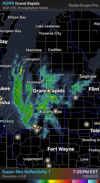
-

November 2025 general discussions and probable topic derailings ...
Cyclone-68 replied to Typhoon Tip's topic in New England
I’m so sorry..I’ll keep you in my thoughts and hopefully your situation will improve -

2025-2026 Fall/Winter Mountain Thread
Maggie Valley Steve replied to Buckethead's topic in Southeastern States
32 at Cataloochee. -
Slowly bleeding in over the mountains
-
11/8-11/10 First Snow and Lake Effect Event
sbnwx85 replied to Geoboy645's topic in Lakes/Ohio Valley
7.5” from today. 3.5” in the last hour. Storm total is 9” including yesterday’s system. -
Now snowing here at 1750. 35.6
-
Temp down to 35 degrees now.
-

-
11/8-11/10 First Snow and Lake Effect Event
snowman33 replied to Geoboy645's topic in Lakes/Ohio Valley
The recent HRRR runs have the main band stationary over Lake County, IL. Gets O'Hare into the heavier totals. -
Started tiny flurries about an hour ago, currenly lightly/moderately snowing and 34°. I'll try and post a pic in a min
-
Yep. It's pretty common that a contrarian will attack science across multiple disciplines. The book Merchants of Doubt describes how the contrarian industry operations, why they do it, and the strategies they use. There was even a "secret" book that apparently had been circulating within the industry to assist contrarians in formulating their attacks on science. it was called "Bad Science: A Resource Book" and was discovered during the tobacco lawsuits. I had no idea how pervasive and devious the industry is. The gaslighting the industry uses is so damaging it takes decades (literally) to unwind the faux beliefs they've sowed in public. This is why I think it may take two more decades before any real traction to mitigate climate change takes hold. Fortunately sanity prevails in the long run. Unfortunately it is usually delayed until a significant amount of damage has occurred.
-
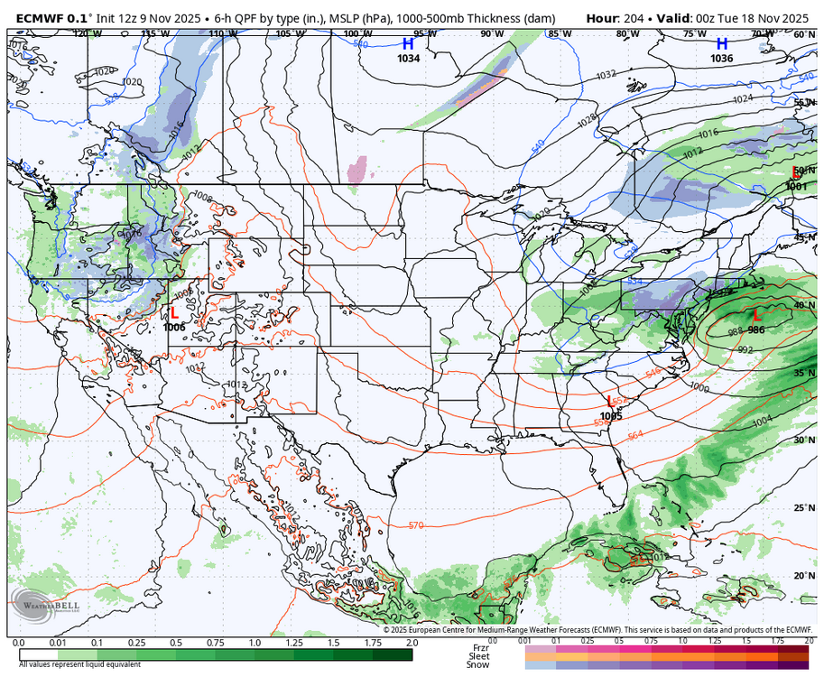
This upcoming week should include both first trackable flakes and first long range trackable but unlikely wintry threat. These are fun seasonal milestones to achieve... Nicely covered by the previous posts. I'm looking forward to some webcams and images from Chicago later tonight.
-

Fall 2025 WX Discussion Thread
Holston_River_Rambler replied to Carvers Gap's topic in Tennessee Valley
@Knoxtronhows it looking down your way? I’d say I’m about 2 hours from temps cooperating for snow. Looks like several places near crossville are already there -

11/8-11/10 First Snow and Lake Effect Event
KeenerWx replied to Geoboy645's topic in Lakes/Ohio Valley
Incredible How much have you gotten from the lake so far? -
Just dropped to 39 here in Black Mountain.
-

E PA/NJ/DE Autumn 2025 Obs/Discussion
Birds~69 replied to PhiEaglesfan712's topic in Philadelphia Region
Stuff moving in, Soutwest to Northesst,....
-
Snowing here at 2000 feet.
-
Unless I'm forgetting something in between, we haven't had a legit lasting HL blocking period with a real -NAO since Jan 2011. We really are due for one
-
I'm just looking to see if we can get some flakes flying
- Yesterday
-

Central PA Fall Discussions and Obs
Blizzard of 93 replied to ChescoWx's topic in Upstate New York/Pennsylvania
Fantasy digital snow tracking season has begun thanks to the 12z Euro.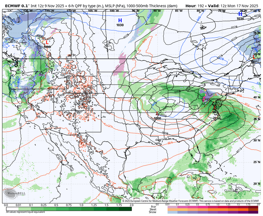
-
Surprise thunderstorm here
-
11/8-11/10 First Snow and Lake Effect Event
sbnwx85 replied to Geoboy645's topic in Lakes/Ohio Valley
2” in the last half hour. My math isn’t great but I think that’s 4”/hour. Bonkers stuff. The rest of the winter is going to be boring after this. -

November 2025 general discussions and probable topic derailings ...
Typhoon Tip replied to Typhoon Tip's topic in New England
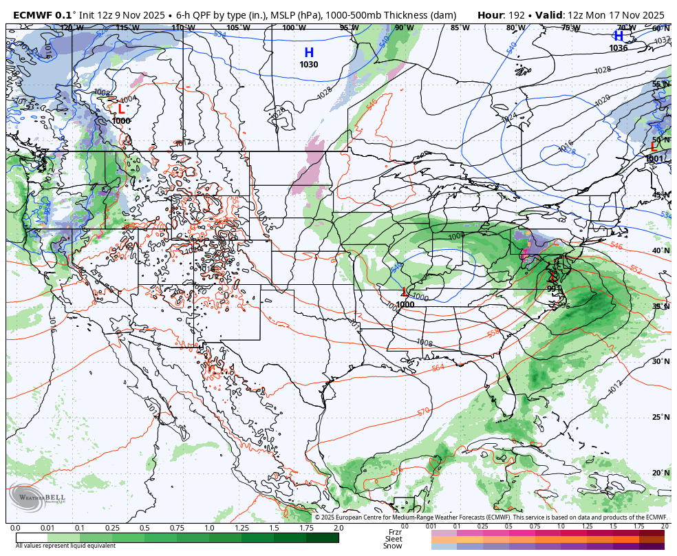
Can't say I actually disagree here ... whether this chart about actually occurs in related, the time frame in question is vulnerable to early season winter expression. This has been very consistent in the numerical teleconnectors, with a lowering -(AO/NAO). The AO and NAO share domain space; they are not exactly collocated. The NAO appears to be weighting the AO down when looking at the different ensembles spatial depictions of the H500 hgt anomalies, the expression of which are also setting up over the western limb ( E/NE Canada/ Baffin Island/ D. Straight ...etc) of the NAO domain. The cyclone genesis/track correlation for that type is S of of. The problems are the notoriously poor handling of the NAO in terms of spatial layout nuances and amplitude. It makes it less useful as a forecast planning tool as say the PNA, which given to it's massive size, tends to be change slower, making it more reliable ( bigger objects taking longer to change and so forth ) Lot of concepts to juggle here ...I know. The operational runs have been fiddling with the notion of above ... hinting in then abandoning, then back in with it... fits that notoriety of being an unruly index. But, so long as the signal is there in both numerical and synoptical presentation, the probability for a cold system type during that period is > than daily climatology.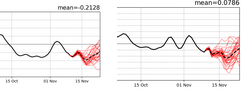
-
Feels like deep winter out there today. Gonna be 60 already by Thu though, and 70 by Saturday.