All Activity
- Past hour
-
 Oh, absolutely! Knowing potential error in forecasting is useful. It can help determine an edge Agreed. Models struggle along tight gradients. That's universal regardless of boundary type (dry-moist, warm-cold, land-water, etc...) ... Advantage will always go to the finer resolution modeling system.
 -
Blah.......ring of nothing
-
Many towns holding large outdoor events will error on the side of caution Friday and Saturday because of the extreme heat warnings and at least a 50% chance of T-storms and reschedule - those 2 combined are dangerous even for younger people. Unfortunately I am sure emergency rooms will be packed with heat related illnesses.
-

2026-2027 Super El Nino
MarcmmKU replied to Stormchaserchuck1's topic in Weather Forecasting and Discussion
What part is wrong? December 1997 and 2004 were indeed +QBO, + ENSO, and below normal. 2018 near normal. Refute the claim. These are numbers not opinions. You can be warm biased without literally lying like you currently are. -

2026-2027 Super El Nino
snowman19 replied to Stormchaserchuck1's topic in Weather Forecasting and Discussion
NOAA has raised the scale again: -
OMG please, please, please....... The surf at most locals is a freakin lake..... wave energy like 20 to 29 ..... boring........
-
 Looks like there will be plenty of power available on the grid for the upcoming heat, no power watches or warning forecast - yet: Those interested in the New England grid should check out this site: https://www.iso-ne.com/isoexpress/web/guest/charts
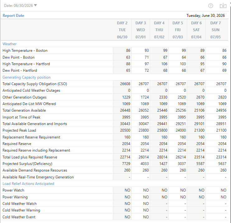
-

Pittsburgh PA Summer 2026 Thread
Ahoff replied to TheClimateChanger's topic in Upstate New York/Pennsylvania
5 minute obs are are 82 at 11:20, 90 will be tough at that pace. -
2026-2027 Super El Nino
snowman19 replied to Stormchaserchuck1's topic in Weather Forecasting and Discussion
Wrong! You’re an idiot. Delete your account -
11AM Round up EWR: 86 LGA: 86 TEB: 85 BLM: 85 New Brnswck: 85 ACY: 84 ISP: 84 PHL: 83 TTN: 83 NYC: 82 JFK: 80
-
I should have done the contest from Thursday to Sunday.
-
some sort of system rolling down from NY state-some areas will go cloudy within a couple hrs...will be interesting to see if any of these systems mess up the heat potential next 3-4 days
-

2026-2027 Super El Nino
csnavywx replied to Stormchaserchuck1's topic in Weather Forecasting and Discussion
The entire warm pool is being discharged. Not only is there not any significant trade resistance this time around (remember '15?), quite a bit of activity has been ongoing away from the equator in addition to being on it. Modeling has steadily been playing catchup since the start of the event as it gradually incorporates all of the additional accumulated wind stress and eckman transport. This will be a colossal east-based event and trying to short it or fade it or talk it down is a fool's game. Look I get it, I like snow too and very early on (Dec/Jan) I was hoping we'd get a moderate event with the indo-pacific warm pool still intact. But that ain't happening. Better off cheering for some exotically warm winter up north that forces some weirdly favorable wave breaks downstream and south. Or save your emotional capital for the backlash Nina period. These big Ninos do have a tendency to cause climate regime shifts, so it's not always a bad thing once the event clears. -
 Some cloud contamination this afternoon may be enough to keep things just under the 90 F threshold here.
 -
Yeah, it has been a great link to use during the heatwaves since it was established. They even have a records section from previous years and months. The Queens corridor into Interior Nassau at times has seen some of the strongest compressional heating east of the Hudson.
-
-
I agree. Was working some summer league games and got in the car at 3-2 and listened to the wheels fall off. They had 2 runners thrown out at the plate in extra innings in the past 2 weeks which could have changed the outcome of both games. Right now they are making fundamental errors which major league players shouldn't. Offensively, they are horrible. I do think Coswer is trying to get more selective at the plate, but still can't hit breaking balls. Neither can Mayo. And who knows what is in Henderson's head since the first month. I feel bad for Baz since he gets no run support. A lot broken right now and it is probably too much to fix.
-
85/71 at my station
-
2026-2027 Super El Nino
csnavywx replied to Stormchaserchuck1's topic in Weather Forecasting and Discussion
GLAAM just dropped from record highs to slightly above normal. I think we're at risk of ruthlessly extrapolating some short term mean reverting variability here. It's definitely coupled to the atmosphere. Hell, there's a standing wave set up in the tropical Pacific already. -
 I find it to be alright...I don't think its anything truly groundbreaking over traditional MOS. What can be very valuable about it is how it provides temperatures based on percentile which can be a huge asset in highly anomalous patterns. For example, I think it was a couple years ago when they were getting very big heat in the West I remember some places where the 90th percentile which was verifying over the typical median which is spit out. I think it absolutely sucks though along boundaries, which I mean can be expected to a degree, but it almost always, always to favor towards the warmer side of the boundary. I've seen NBM bust by like 15F because it had the warm front blowing through and that never happened. I also like how it does not have the limit of reporting cloud cover...so it will pick up on the high clouds while traditional MOS will spit out CLR
 -

2026-2027 Super El Nino
bluewave replied to Stormchaserchuck1's topic in Weather Forecasting and Discussion
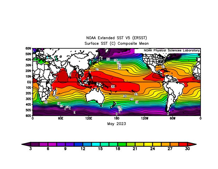
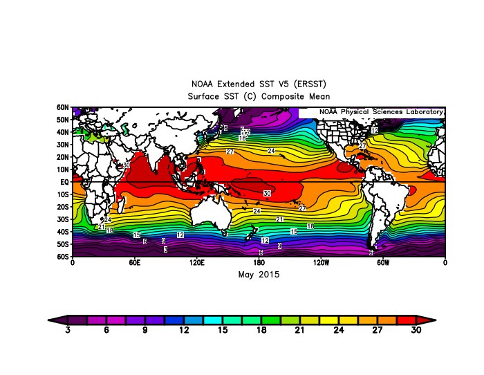
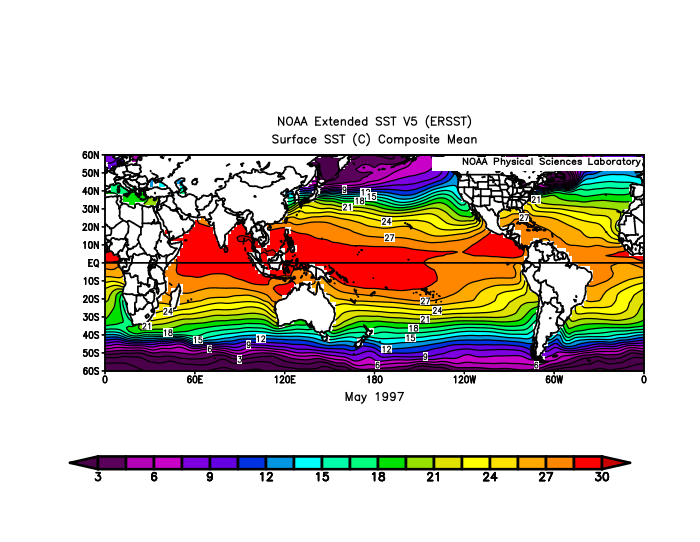
The more Niña-like pattern is probably being enhanced by how much warmer the Indian Ocean through the Maritime Continent to around the Dateline is than all the other previous super El Niños at this time of year. So we get a westward extension of the forcing overlapping with the El Niño standing wave. Notice how the dates of the record warmth going back to March in the East coincided with the forcing moving from the Indian Ocean to the WPAC. Plus the interaction between the record SSTs in the Mid-latitudes could also be influencing the pattern. Even the state of the Arctic could be playing a role. The extent of the +30C pool is larger than 2023 at this time when we were having a much cooler El Nino-like pattern from the late spring into summer. So we are getting a head start on the Niña-like influences which waited until closer to the winter in December 2015 and January 2024 to occur. +30 C warm pool expansion since the late 1990s during the late spring of developing super El Niños
-
Wow, 84 here. Was 88 yesterday
-

E PA/NJ/DE Summer 2026 Obs/Discussion
JTA66 replied to PhiEaglesfan712's topic in Philadelphia Region
Currently my forecasted highs for Thursday and Friday are only 100F. Somehow that feels like a small victory. (But yeah, I taking the over.) -
89 here, already surpassed yesterday’s high of 88. More humid today as well.


