All Activity
- Past hour
-

Pittsburgh/Western PA WINTER ‘25/‘26
jwilson replied to Burghblizz's topic in Upstate New York/Pennsylvania
If you believe long-range CFS forecasting, it could be a spring loaded with severe weather opportunities. High shear predicted going forward for most of Western PA and the Midwest. I've already seen a couple (weak) hook echoes attached to supercells on radar nearby, and the dying remnants of a wall cloud. Neither actually dropped a tornado, it would seem, but nonetheless unusual, especially for this early. -
March is marching
-
Was gonna say, the change we want to see
-
Just about to say, the 18z NAM is SE. Not that every run matters, but I'd take it for sure.
-
18z nam…
-

2026 Mid-Atlantic Severe Storm General Discussion
NorthArlington101 replied to Kmlwx's topic in Mid Atlantic
Wind driven moderate feels like a decent guess for Monday right now. I’d lean 45% wind sig 2 10% tor sig 1 Hail idc -

Central PA Spring 2026 Discussion/Obs Thread
Itstrainingtime replied to Voyager's topic in Upstate New York/Pennsylvania
LSV already upgraded to a 30% risk for Monday. Ominous. SPC mentioning strong to intense tornadoes. And it's only March. -
Seasons in seasons. got my snow now I want warmth.
-
Brian loves the warmth. Use to be a snow weenie.
-
doubt it-bad pattern and climo gets worse by the day. I'm ready for spring...
-
has forced squall line/qlcs, with damaging winds and embedded tors written all over it.
-

E PA/NJ/DE Spring 2026 Obs/Discussion
RedSky replied to PhiEaglesfan712's topic in Philadelphia Region
Spring forward even more -
No it won't. I hate severe, unless it's severe cold.
-
Don’t worry buddy, we’ll get ya to snow one more time.
-
SPC already has a 45% area for Day 3 in S IN, S IL, and W KY.
-
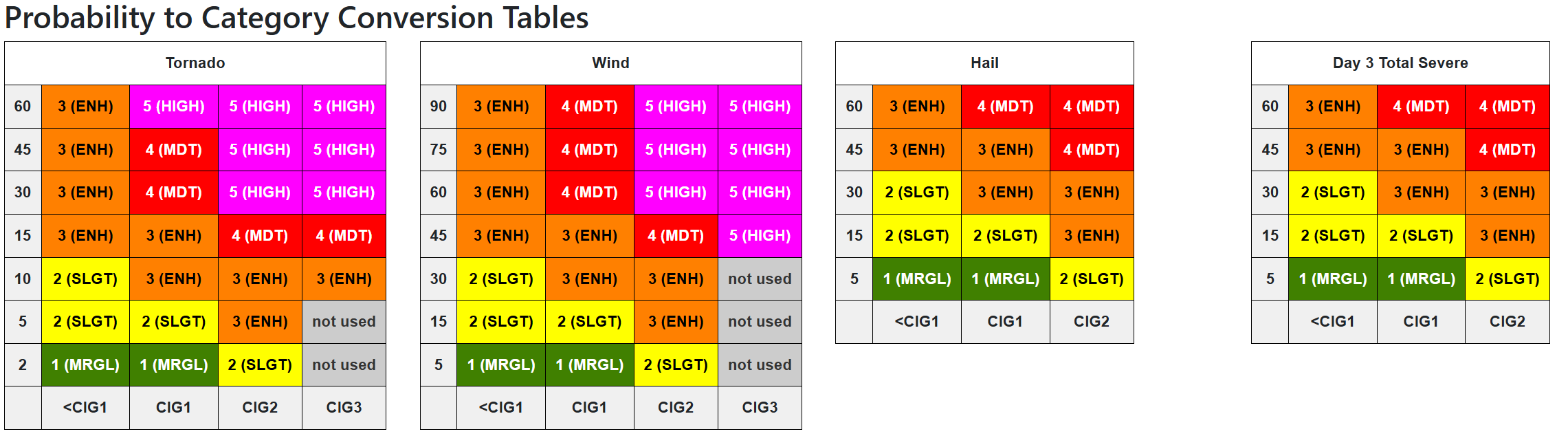
Remember the new conversion tables
- 174 replies
-
- 2
-

-
- severe
- thunderstorms
- (and 7 more)
-
Van Wert (of course lol) wants to kick off the weekend with an 80mph Tpole snapping semi flipping dust storm lol. Tis a bit breezy with multiple 60+ gusts here. for the last 4-5 hours. most N/S highways and Interstates are closed with flipped semi's around here. Preliminary Local Storm Report National Weather Service Northern Indiana 127 PM EDT Fri Mar 13 2026 ..TIME... ...EVENT... ...CITY LOCATION... ...LAT.LON... ..DATE... ....MAG.... ..COUNTY LOCATION..ST.. ...SOURCE.... ..REMARKS.. 0115 PM Non-Tstm Wnd Dmg 2 N Van Wert 40.89N 84.58W 03/13/2026 Van Wert OH Emergency Mngr Multiple semi trucks rolled over and power poles down in Van Wert county. A lot of blowing dust too.
-
I mean if it continues I see 45% wind hatched at least for sure
-
Good lord this wind is kinda shitty.
-
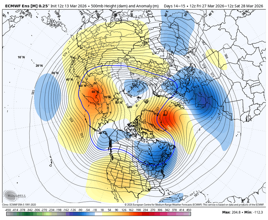
WB 12Z EPS: may be a month too late but worth keeping an eye on the last week of March period.
-
Not really.
-
that's top tier for a synoptic wind event in this region.
-
86 mph gust at KMIE. Multiple semis blown over on I 69 south of FWA.
-
Yeah wowza thankfully the moisture isn’t there but still adequate .
-
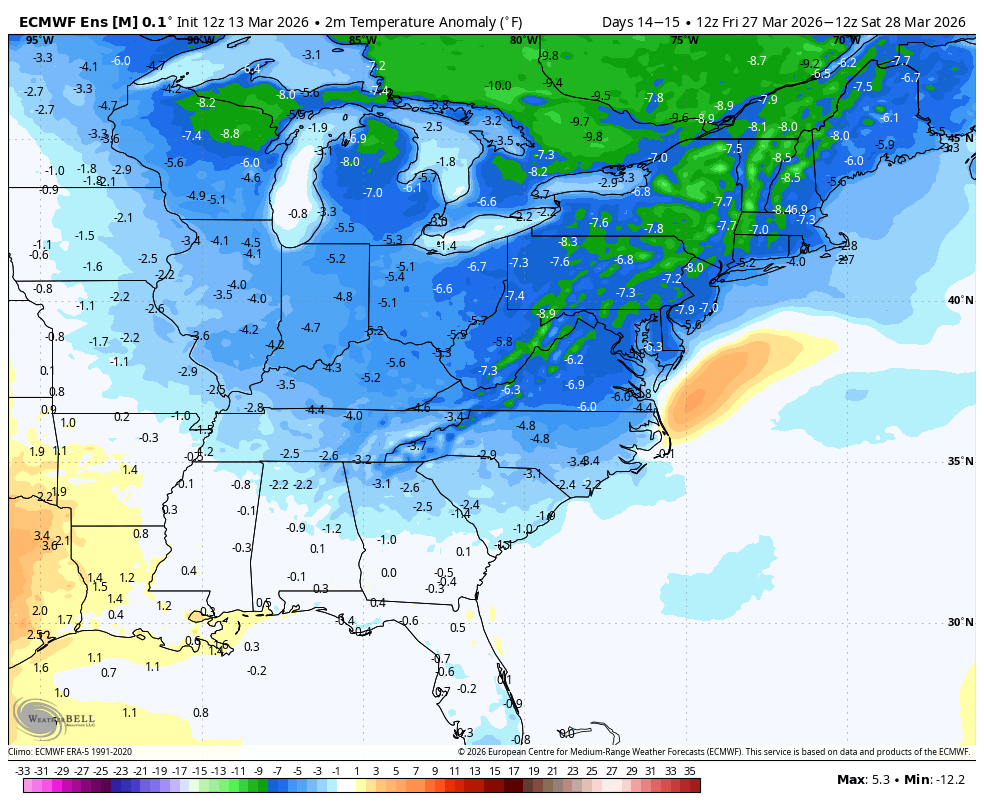
LWX afternoon AFD DISCUSSION... KEY MESSAGE 1...A strong cold front will arrive Monday, bringing strong winds and the potential for severe thunderstorms. The Mid Atlantic should be in the warm sector of a powerful low pressure system over the Great Lakes on Monday. A deep upper trough pushing east of the Mississippi Valley will be taking on a negative tilt. Winds throughout the atmosphere will be very strong, along with notable low level wind shear (though more speed than direction). Dew points in the upper 50s to lower 60s and modest mid level lapse rates will limit instability but there should still be enough to support convection. The thermodynamic profile could be one of the primary factors into just how significant the severe weather is. There is some threat for some leading cellular development in the warm sector which could pose a wind and tornado risk. Then, a squall line is likely to develop ahead of the sharp cold front. Damaging winds, some potentially significant, will be a threat with the squall line. A QLCS tornado threat could also be present, although the shear vectors will be more parallel to the line vs. the more favorable perpendicular. Seasonally high precipitable water will also result in heavy rain, although storms will be moving quickly. Timing is still a bit uncertain, but the most favorable conditions combined with afternoon/early evening timing are projected east of the Blue Ridge. SPC has highlighted a somewhat rare 30 percent day 4 severe outlook for this area. Besides the convective winds, gradient winds will also be strong immediately ahead of and behind the front which could cause additional localized tree damage and/or complicate recovery efforts. Cold air will be rushing in immediately following the frontal passage. At a minimum, the Allegheny Mountains will change to snow for a time in upslope conditions. It remains uncertain if any postfrontal precip lingers to the east long enough to change over.