All Activity
- Past hour
-

E PA/NJ/DE Summer 2026 Obs/Discussion
The Iceman replied to PhiEaglesfan712's topic in Philadelphia Region
With that main system going northeast of the city this morning, there should be a boundary set up right across SE PA. Actually looking like one of the better tornado threats in a while. -
Second heavy rain meso issued by WPC Mesoscale Precipitation Discussion 0766 NWS Weather Prediction Center College Park MD 1128 AM EDT Sat Jul 18 2026 Areas affected...portions of the coastal Mid-Atlantic Concerning...Heavy rainfall...Flash flooding possible Valid 181528Z - 182128Z Summary...A couple rounds of showers and thunderstorms with heavy rainfall are expected into late this afternoon. Hourly rain amounts to 2.5" are possible, which could lead to flash flooding in urban areas. Discussion...A thermal boundary extends through portions of the Mid-Atlantic States. Near the boundary, showers and thunderstorms are showing some slight backbuilding character while moving northeast into New York City. Precipitable water values are 1.4-2". MU CAPE is 500-5000 J/kg across the region, with the maximum on the Eastern Shore. Effective bulk shear is ~40 kts. One bout of heavy rainfall in the very near term is expected across southeast NY and portions of CT, while later development is expected to the southwest which should ride up the boundary back into the Tri-State area. Hourly rain amounts to 2.5" are possible either from backbuilding, cell training, or mesocyclone formation. This would be most problematic in urban areas.
-
Picked up a little over an inch already and looks like another batch of moderate rain should be moving in from PA over the next couple of hours
-

2026-2027 Super El Nino
40/70 Benchmark replied to Stormchaserchuck1's topic in Weather Forecasting and Discussion
Good analogy....Snowfall won't prevent a cutter, but it can delay/retard the warming perhaps even trigger the development of a triple point low, while the upper levels still flood with warmth. Difference here is the lower levels are most responsive to ENSO, and it's actually the upper levels that lag. -

2026-2027 Super El Nino
snowman19 replied to Stormchaserchuck1's topic in Weather Forecasting and Discussion
The South American weather service updated yesterday, they kept the El Niño Costero (coastal) warning in effect, their disco says it’s very likely that a strong El Niño Costeto goes right into April, 2027 The well coupled El Niño standing wave is sticking out like a sore thumb And the TC parade has begun in the central, western and eastern PAC, with the most activity projected in the EPAC -

2026 Spring/Summer Mountain Thread
Maggie Valley Steve replied to Buckethead's topic in Southeastern States
After another round of thunderstorms overnight, another chance today with rainfall rates up to 3 inches per hour are possible.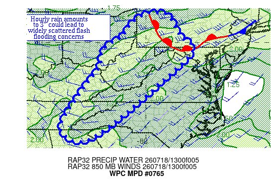
-
the wild card throughout the day is how the smoke will affect the daytime heating and instability - this is an odd setup
-

Saturday, July 18, 2026 Thunderstorm/Severe Weather Potential
LSC97wxnut replied to weatherwiz's topic in New England
Not sure which thread to put this in, but are the storms in New York all there is for today, or are those supposed to die off and we'll see more later? -

Saturday, July 18, 2026 Thunderstorm/Severe Weather Potential
WxWatcher007 replied to weatherwiz's topic in New England
Discrete this afternoon, the line this evening. -
Their meadow tea is amazing.
-
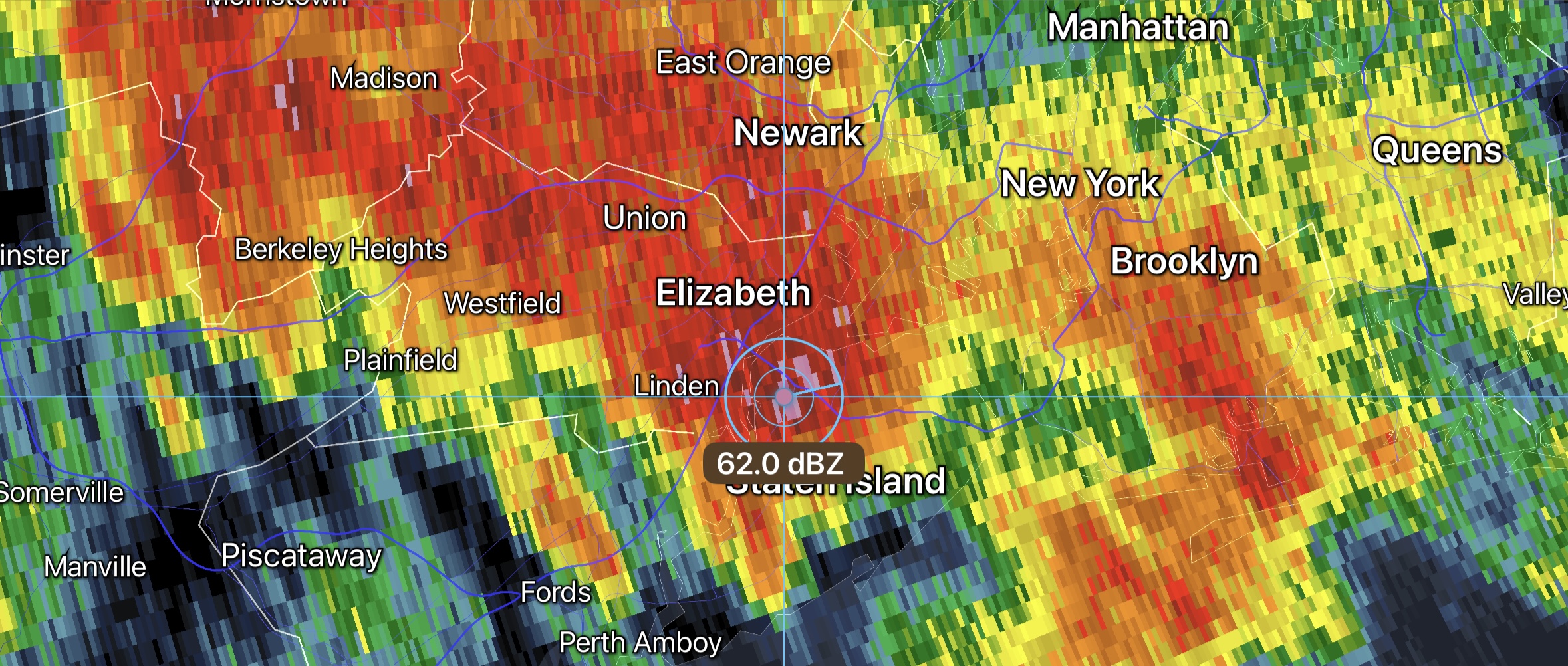
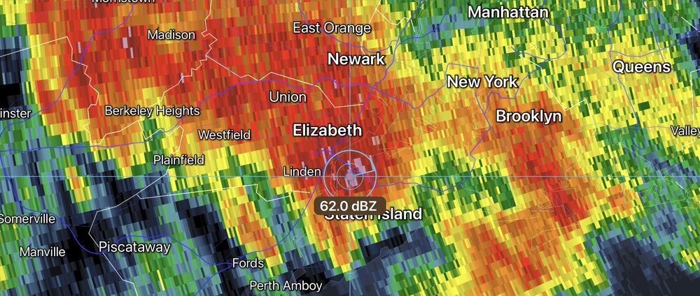
Flash flood threat NYC metro with this warm frontal training first round of convection. Some hail also beginning to show up. Tropical PWATS with this. Mesoscale Precipitation Discussion 0766 NWS Weather Prediction Center College Park MD 1128 AM EDT Sat Jul 18 2026 Areas affected...portions of the coastal Mid-Atlantic Concerning...Heavy rainfall...Flash flooding possible Valid 181528Z - 182128Z Summary...A couple rounds of showers and thunderstorms with heavy rainfall are expected into late this afternoon. Hourly rain amounts to 2.5" are possible, which could lead to flash flooding in urban areas. Discussion...A thermal boundary extends through portions of the Mid-Atlantic States. Near the boundary, showers and thunderstorms are showing some slight backbuilding character while moving northeast into New York City. Precipitable water values are 1.4-2". MU CAPE is 500-5000 J/kg across the region, with the maximum on the Eastern Shore. Effective bulk shear is ~40 kts. One bout of heavy rainfall in the very near term is expected across southeast NY and portions of CT, while later development is expected to the southwest which should ride up the boundary back into the Tri-State area. Hourly rain amounts to 2.5" are possible either from backbuilding, cell training, or mesocyclone formation. This would be most problematic in urban areas.
-
If this is the appetizer, can't wait for the entree
-

2026 Atlantic Hurricane Season
Windspeed replied to Stormchaserchuck1's topic in Tropical Headquarters
If nothing else, at least it is a feature to track and watch. There is nothing much to add beyond the most recent posts. Spot on. It's a mid-level system / pulsing MCS. Let's see if it will ramp up again this evening. We need persistent deep convection to drive inflow and get vorticity to resolve in the low levels. That happening out over the GOM sooner than later determines if we get get a TC or just beneficial rains to the upper peninsula. Again, it's something interesting to watch, and we may not get many of these this season. -
Nice morning for a bike ride. 0.22" this morning. 3.87" for the month.
-
That’s fair, I like to think most of us here understand how these discussions work but weenies may not. The clouds and smoke as mentioned will obviously help tell the story of what may or may not happen later.
-
@high risk could there be some differential heating boundaries later? I'm assuming that with the rain/storms in PA, the WF will not push as far north and increase risk for a few tornadoes?
- 1,060 replies
-
- 1
-

-
- severe
- thunderstorms
- (and 7 more)
-

Saturday, July 18, 2026 Thunderstorm/Severe Weather Potential
weatherwiz replied to weatherwiz's topic in New England
Definitely going to be interesting early evening, guidance increases instability just out ahead of the main activity moving in. If we can get upwards of 1500 J of MLCAPE to build in like some guidance shows there will be some wind damage for sure. Of course given the directional shear there would be the risk for a few tornadoes. Won't be getting much sun today but our instability is going to be coming from increasing dewpoints...if we get dews 73-74-75 in...watch out -
Make sure you check for ticks!
-
But why no watch for later yet?
-
Just wanted to clarify since some would assume it covered the entire days activities.
-
The steady rain in NE PA is drying up. All these things are great signs. Full steam ahead for mid to late afternoon.
-
You don’t say
-
Should be getting a MCD soon, probably in next hour
- 1,060 replies
-
- 1
-

-
- severe
- thunderstorms
- (and 7 more)
-
This is only regarding the morning threat.
-

2026 Mid-Atlantic Severe Storm General Discussion
batmanbrad replied to Kmlwx's topic in Mid Atlantic
visible does seem to show some decent clearing as you get west of MoCo...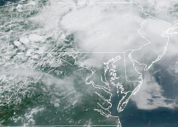
- 1,060 replies
-
- 2
-
-
- severe
- thunderstorms
- (and 7 more)