All Activity
- Past hour
-
 -13F
-13F -
Definitely an interesting battle between AI and the legacy models in the extended. Friday hasn’t trended any more exciting yet.
-
Most guidance continues to show this threat. Still some discrepancy on where the best totals will be but it looks like to me the highest totals would be 3" wherever that sets up. Everywhere else it looks like a 0.5-2" at most.
-
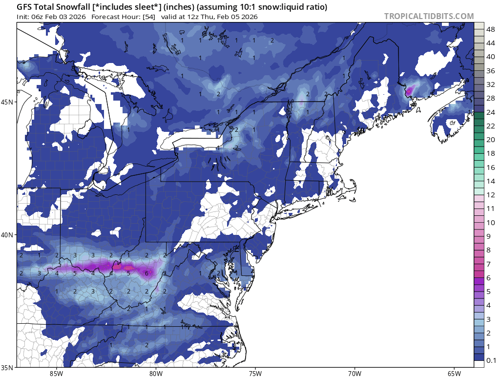
6Z GFS. Time to reel this big fish in.

-
11F. Snow Pack and clear skies doing its thing
- Today
-

E PA/NJ/DE Winter 2025-26 Obs/Discussion
MickeyTim6533 replied to LVblizzard's topic in Philadelphia Region
man, this place is a morgue -

2025-2026 ENSO
so_whats_happening replied to 40/70 Benchmark's topic in Weather Forecasting and Discussion
This is rather disappointing and honestly can't say I'm surprised. Something like this happened very similar last year around this time with the pinching off of a little lobe of SPV in the Eastern US/ SE Canada. It was around mid to late February when this started to take hold..thumb.gif.3c2e892d8ed0a90f31e570de14c0b986.gif)
-
Who knows, these days. Could be something or nothing.
-
Looks like 0.2" to 0.5" potential (snow not QPF sadly) ... Friday night into Saturday may start to show slight snow potential too in advance of bitterly cold arctic outbreak. Would expect some in mountains at very least.
-

February 2026 Medium/ Long Range Discussion: Buckle Up!
stormtracker replied to Weather Will's topic in Mid Atlantic
Not a snowstorm I wanna catch. -
Middle TN has had the temps but the middle finger on the snow dept. ouch.
-
Love this thread.
-

WxUSAF's weak ass frontal passage thing.
WxWatcher007 replied to dailylurker's topic in Mid Atlantic
This reminds me of needabiggerboat or something like that, who probably had the funniest stuff in the history of this forum. -

February 2026 Medium/ Long Range Discussion: Buckle Up!
Jebman replied to Weather Will's topic in Mid Atlantic
Lets reel in PD 3! -

February 2026 Medium/ Long Range Discussion: Buckle Up!
Ji replied to Weather Will's topic in Mid Atlantic
Euro had a vd snowstorm to out south lol -
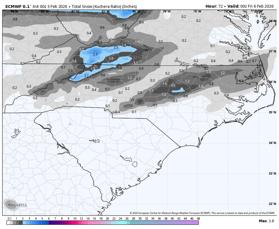
0Z Euro targets RDU with a nice hit:
-
Running way under forecast lows again tonight. Forecast was 21, currently 16.
-
Southeast ridge said, "Remember me?!"
-
Let's see if it's own ensambled will follow suit.
-
Down to 17.6 seems like my area has been the cold zone on LI. The rest of the island seems to be low 20s
-
 GFS is brutal
 -
Oz GFS is coĺd
-
Mid Atlantic guy but I was in last threads and you guys go nuts again and I think we will again Plus we really can’t warm up because south winds over your snowpack meets our snowcrete!
-
Got 7.2" Analysis has me at 5.5-5.9". Not great, not terrible. Seems that one station has messed everything up in Lee. EDIT: Just realized this includes the previous storm. Got 1.5" before zr and 2.0" after for a total of 10.7" so it's way off.
-

E PA/NJ/DE Winter 2025-26 Obs/Discussion
snowwors2 replied to LVblizzard's topic in Philadelphia Region
Only made it to 28.8° today!


.gif.9829953170999df3e89c68755b6940f3.gif)


