All Activity
- Past hour
-
 No one likes a lot of freezing rain. Give me .005to .10 of an inch after a big snowfall, It looks fantastic. Anything more just destructive and no need for it.
 -
I'm honestly not sure how much further this can come north from a phase alone (famous last words). The Euro is the highest latitude it can reach bar confluence retreat (which is a possibility). Realistically I think we see a slightly messier phase so we don't need to worry that much even if the confluence is a bit overdone.
-

January 2026 regional war/obs/disco thread
ineedsnow replied to Baroclinic Zone's topic in New England
there will be zero mixing anywhere -

Possible Record Breaking Cold + Snow Sunday 1/25 - Tuesday 1/27
MANDA replied to TriPol's topic in New York City Metro
Gotta like that look. Just need to keep it or improve on it. If we can keep these 18Z trends going at 00Z and then 12Z tomorrow that would be great....at least on the EURO, GGEM and UKMET. If the GFS comes to the party and stays so much the better. -
I really don’t want to see Bam take a victory lap.
-
.thumb.png.4150b06c63a21f61052e47a612bf1818.png)
January 2026 regional war/obs/disco thread
HIPPYVALLEY replied to Baroclinic Zone's topic in New England

-

January 2026 regional war/obs/disco thread
CoastalWx replied to Baroclinic Zone's topic in New England
I taught him better -
I fucking don't. Sorry. Again I hope your area gets good snow. I hope we all do. But if shit has to get amped just so you can get 24" while I get 4 and slop then it will not be as fun for a lot of people
-

January 2026 regional war/obs/disco thread
Damage In Tolland replied to Baroclinic Zone's topic in New England
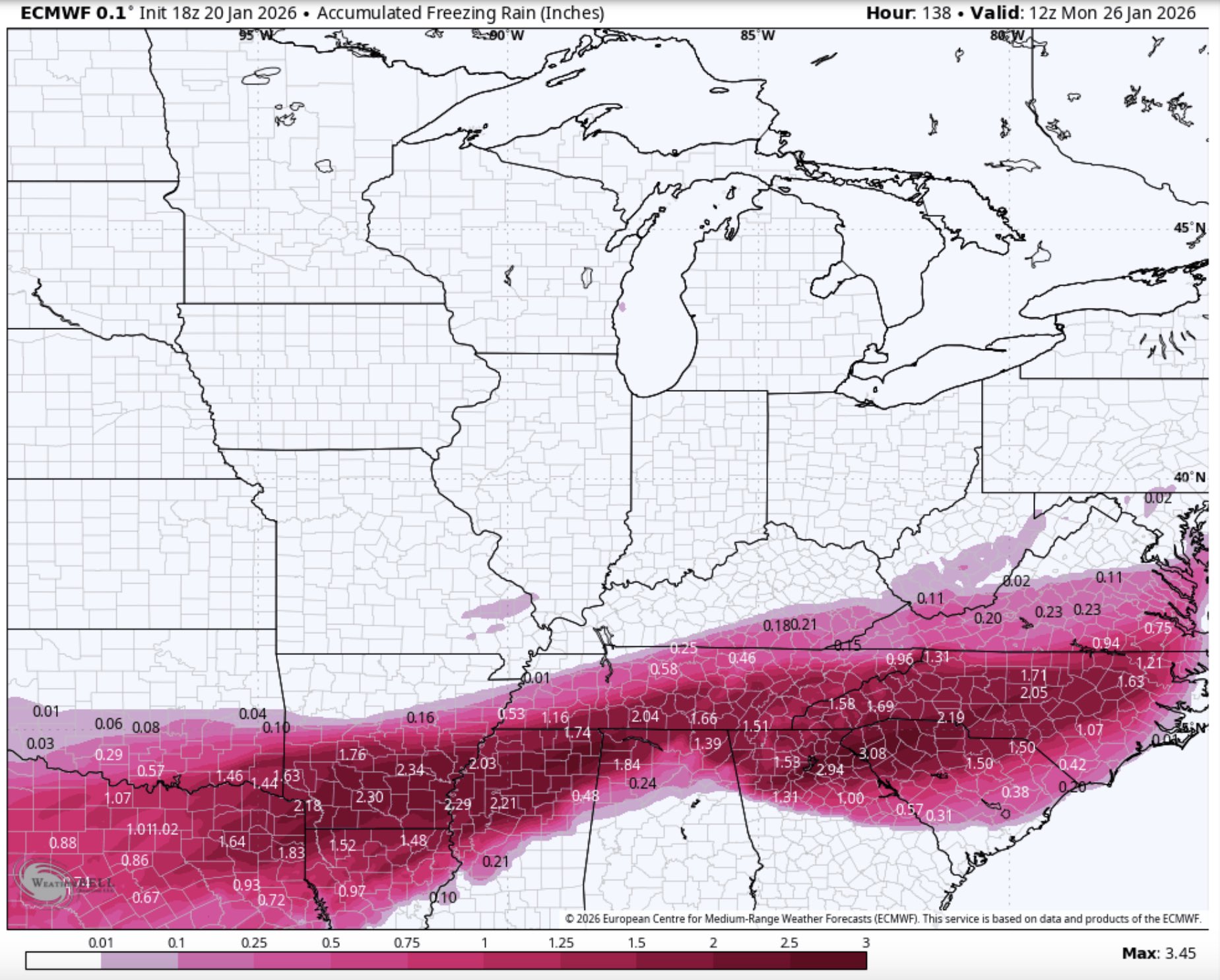
18z Euro 1-4” of ZR down south. Someone is getting 98 ice down there
-
Why are you trying to spoil all of the cliff diving
-
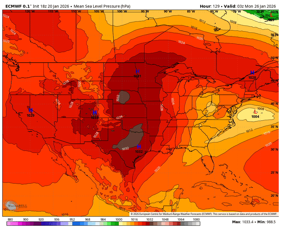
I still wouldn't want to cheer for more phasing as that will introduce a lot more mixing issues. We saw that scenario a day or so ago with some models taking the primary into TN and KY, then doing a hop to the coast. The 18z Euro has hints of this with lower MSLP into WV. The 12z run has much less evidence of this. Just something to keep tabs on moving forward.
-
Finished dinner and pulled out one of these to cope with the thread(s). Saving the rest for Saturday.
-
I was looking at that member pin map in banter, we are so close. Are you near the Jordan Springs BBQ gas station?
-
Maryland Mesonet episode is on Outdoors Maryland right now. I know it's a repeat, but very cool!
-

January 2026 regional war/obs/disco thread
Prismshine Productions replied to Baroclinic Zone's topic in New England
Hell way it keeps ticking we might score double in the Valley while the coast gets skunked again with mixed Sent from my SM-S166V using Tapatalk -

Richmond Metro/Hampton Roads Area Discussion
RVASnowLover replied to RIC Airport's topic in Mid Atlantic
Euro had sleet reaching close to Fredericksburg. The HP was weaker. Something to keep an eye on. Mixing seems likely though southside and into HR -
So Lucy has arrived. Ugh.
-
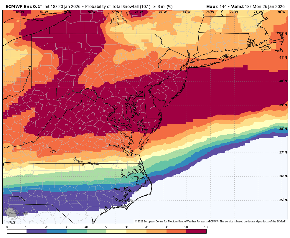
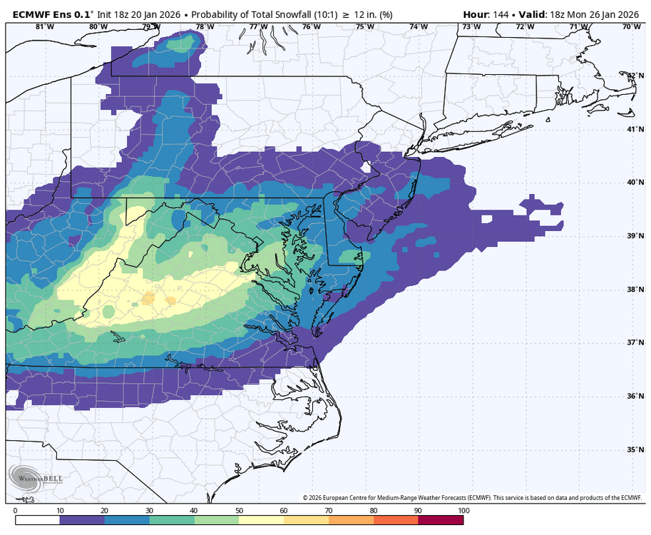
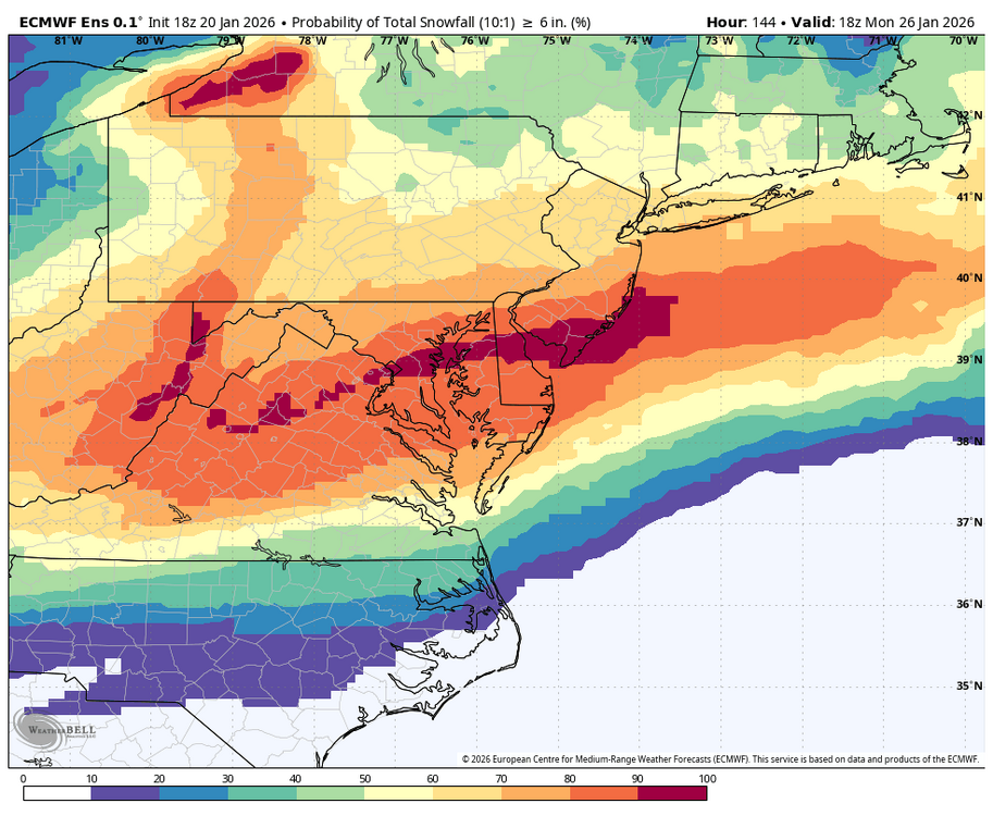
Ok, dusted off the EPS snow prob. Maps. 12, 6 and 3 inches from WB 18Z EPS

-
This is a rare storm as far as thermals go. We have legit arctic air in place for this one. I want it as amped as it can get.
-
I get your concern, but as is, we're good and I think this is where we want it, no more amplification
-
nuked++++++++++
-

2025-2026 Fall/Winter Mountain Thread
BlueRidgeFolklore replied to Buckethead's topic in Southeastern States
While I agree, this seems like one of those Arctic air masses that can show more suppression later on. We’ll know more soon but this is one of those setups where it could trend south. -
Well boys I started up the hill to the top of the cliff. Going to wait there for a bit. Holler if things get better if not I’ll jump Friday. It hurts when u hit the bottom
-
The temps on the Euro could be cause for concern. The gradient between northern Delaware at 16 degrees and the Beaches 60 miles away at 35 is interesting.
-
If trends are continuing to move it north…that means the High is not as strong as first though.