All Activity
- Past hour
-
The 7th driest June 1st to 16th at Islip. Time Series Summary for ISLIP-LI MACARTHUR AP, NY Driest June 1st to 16th Click column heading to sort ascending, click again to sort descending. 1 1967-06-16 T 0 2 1994-06-16 0.15 0 3 2005-06-16 0.23 0 4 1988-06-16 0.27 0 5 1999-06-16 0.31 0 6 2021-06-16 0.36 0 7 2026-06-16 0.38 0 8 1981-06-16 0.64 0 9 1973-06-16 0.67 0 10 2004-06-16 0.68 0
-

Junorch obs and discussion 2026
Damage In Tolland replied to Damage In Tolland's topic in New England
These things always seem to fizzle in summer with convection involved -
I wonder if we see a small high risk on the new D1. That is a wild environment that will be evolving today. That is a very elongated line of supercells which develop ahead of the cold front later and not to mention supercells which develop along and ride parallel to the front and will be ingesting destabilizing air from the south.
-
But the CAPE is too low! "Only" 1291! Lapse rates not high by Midwest standards. So it works there but not here?
-
I’m buying decent rains
-

Central PA Summer 2026 Discussion/Obs Thread
pawatch replied to Voyager's topic in Upstate New York/Pennsylvania
With the blues skies it was still warm out in the sun. But beautiful day! -
Central PA Summer 2026 Discussion/Obs Thread
pawatch replied to Voyager's topic in Upstate New York/Pennsylvania
55 degrees and rain showers this morning. Yesterday low 42 degrees was 13 degrees below normal. Record was 40 degrees set in 1960. -
Forget the stupid hazard type. But holy hell WTF
-
Both TWN and WUN show far more sun today than the past while and even getting warmish to 23C. TWN has gusts to 80 km/h just after midnight for 3 hr but the sus part is sustained (40 km/h) and gusts are stable during the early hours, there s no way with a strong low and dynamic system like that. Gusts may get even higher. WUN has my lowest at 1am at 989mb. TWN was wildly off with temps this week; about 5C off a few recent days including now.
-
Junorch obs and discussion 2026
Damage In Tolland replied to Damage In Tolland's topic in New England
Sell the coastal . Convection will rob most of the moisture -
Yeah that one hurt a lot.
-
Good, we need the R+.
-

2026 Mid-Atlantic Severe Storm General Discussion
Eskimo Joe replied to Kmlwx's topic in Mid Atlantic
Let's be honest for a moment, a lot of managers and "senior leaders" are excited about AI because it means less staff. Focusing on weather, the only advantage I've seen from the AI models so far is they come out faster. I haven't seen any meaningful performance in accuracy beyond D3 as a customer of the weather enterprise. That includes the private sector and government. I've been in a few private sector test groups with AI guidance for "perfect long range forecasting", and the verification scores beyond D7 are laughable. I don't need a 15 day forecast, I just need 95% confidence out 72 hours! - Today
-

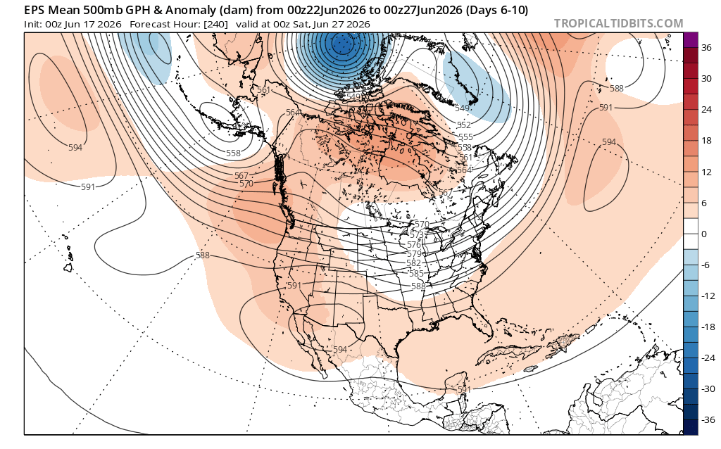
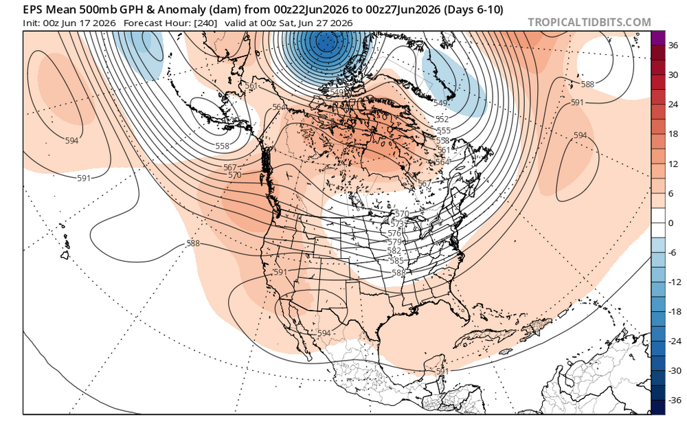
2026-2027 Super El Nino
bluewave replied to Stormchaserchuck1's topic in Weather Forecasting and Discussion
The 500 mb pattern is beginning to look more Nino-like during the second half of June. Finally getting the familiar ridge just west of British Columbia. This is allowing the typical June El Niño trough to form near the Great Lakes.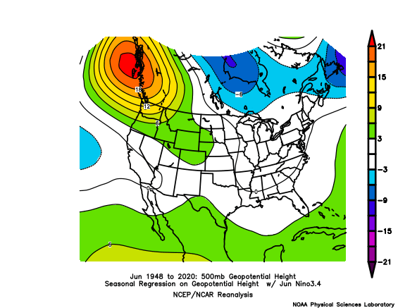
-

Central PA Summer 2026 Discussion/Obs Thread
Mount Joy Snowman replied to Voyager's topic in Upstate New York/Pennsylvania
Looks like 58 will be the low. Humidity creeping up today but nothing too bad. Looks like fairly minimal action tomorrow. Carry on. -

2026-2027 Super El Nino
PhiEaglesfan712 replied to Stormchaserchuck1's topic in Weather Forecasting and Discussion
Get ready for 30C minimums in November and December. -

2026-2027 Super El Nino
snowman19 replied to Stormchaserchuck1's topic in Weather Forecasting and Discussion
And this is quite the WWB…. -

Potential Tropical Cyclone One
LongBeachSurfFreak replied to WxWatcher007's topic in Tropical Headquarters
Track and structure scream throw in the towel for this ever being named. . -

Occasional Thoughts on Climate Change
WolfStock1 replied to donsutherland1's topic in Climate Change
Google is your friend. https://www.agweb.com/opinion/doomsday-addiction-celebrating-50-years-failed-climate-predictions https://bradleyhook.com/why-extreme-climate-change-predictions-failed-what-we-can-do-now/ https://reason.com/2025/04/16/3-apocalyptic-climate-change-predictions-that-failed-to-come-true/ https://www.forbes.com/sites/michaelshellenberger/2019/11/25/why-everything-they-say-about-climate-change-is-wrong/ (does include some Al Gore stuff) etc. etc. Just search on "climate change failed predictions" -
Let’s coastal next week.
-
No hope for drought ravaged areas of northern piedmont. Discussion from RAH: QPF still remains quite variable and in flux, but remains rather light (mostly under a 0.25 to 0.50). The GFS shows absolutely nothing over the drought plagued northern Piedmont of NC. The hi-res models are now coming into range, but do not offer much hope. We need a pattern change. The pattern has been so persistent with either a dominate ridge aloft or a zonal flow. The areas east of the Appalachians have had an atypical mountain shadow hole in the rainfall due variations of a dominate westerly flow in the mid levels for quite some time. We need a break in the mid/upper levels over our region or a dominate Bermuda high with SW flow aloft to consistently bring Gulf moisture and lift to the region. This is not seen in the foreseeable future. The zeros keep stacking up.
-
Potential Tropical Cyclone One Discussion Number 4 NWS National Hurricane Center Miami FL AL012026 400 AM CDT Wed Jun 17 2026 The center of the low pressure area is very near the Middle Texas coast, and offshore buoy observations indicate that maximum winds remain 25 kt. A line of deep convection has formed over the northwestern Gulf waters since the last advisory, but due to strong westerly shear, this activity is located more than 120 n mi to the east/southeast of the low-level center. As a result, the latest Dvorak classification from TAFB is Too Weak To Classify, meaning the system does not have the convective organization necessary to be designated as a tropical cyclone. The current motion is northeastward, or 045/5 kt. The system is embedded in strengthening low- to mid-level southwesterly flow, and with another trough approaching from the northwest, it is expected to accelerate northeastward today. The track guidance has shifted slightly westward on this cycle, and the center of the low is therefore likely to straddle the Texas coast for much of the day, before moving farther inland over eastern Texas or Louisiana tonight. The NHC official track has been nudged westward, close to the TVCN and HCCA consensus aids. The prospects for this system to become a tropical cyclone may be decreasing. With the low-level center unlikely to fully emerge over the Gulf waters for an appreciable amount of time, and 25-30 kt of westerly shear expected to continue for the next 12 hours, it will be difficult for the system to gain the convective organization necessary to become a tropical cyclone before it moves inland tonight. Even if the system doesn't become a tropical cyclone, there could still be some strengthening of the wind field well east of the center during the day, and the NHC official forecast will continue to show a peak of 35 kt in 12 hours. After that, all of the global models now show the system opening up into a trough over Louisiana by tonight. The official forecast shows the system as a remnant low at 24 hours, but it's entirely possible it will have dissipated by then. The global models show the remnant low-level vorticity continuing eastward across the Southeast U.S. on Thursday and Friday, and the ECMWF, Canadian, and UKMET models indicate that a low pressure system could redevelop, especially once the system moves offshore over the western Atlantic. The exact nature of this low is unclear at this time, but we will monitor model trends for the possibility of tropical cyclone formation over the western Atlantic late this week or this weekend. Regardless of whether the system becomes a tropical cyclone, heavy rainfall and life-threatening flash flooding will be the primary hazards with this system. KEY MESSAGES: 1. Potentially life-threatening flash flooding and urban flooding are likely through Thursday across southern Louisiana, southern Mississippi, southern Alabama, southwestern Georgia and the Florida Panhandle, with possible flooding near the Upper Texas coast. Ongoing heavy rainfall could prolong the flood threat into the weekend. 2. Tropical-storm-force winds are expected along the Louisiana coast today from Sabine Pass to Morgan City where a Tropical Storm Warning is in effect. 3. Minor to moderate coastal flooding is expected along portions of the Upper Texas and Louisiana coastlines today. FORECAST POSITIONS AND MAX WINDS INIT 17/0900Z 28.0N 96.7W 25 KT 30 MPH...POTENTIAL TROP CYCLONE 12H 17/1800Z 29.1N 95.2W 35 KT 40 MPH...TROPICAL STORM 24H 18/0600Z 31.1N 92.8W 25 KT 30 MPH...POST-TROP/REMNT LOW 36H 18/1800Z...DISSIPATED $$ Forecaster Berg
-
.thumb.jpg.6a4895b2a43f87359e4e7d04a6fa0d14.jpg)
Central PA Summer 2026 Discussion/Obs Thread
Yardstickgozinya replied to Voyager's topic in Upstate New York/Pennsylvania
I bet he's feeling good about himself today. -
If it was bit stronger and a bit larger, yeah it could shunt the surface moisture flow into the OH Valley. But I think its too little too late. It's already embedded into the established SW flow of the incoming trough over the conus and will like be absorbed into it. Not a non 0 effect but not as much as if it were stronger IMO. Crazy jet dynamics with the incoming trough, gonna be hard to overcome those.
-
Yep. They're really bullish on keeping the main event long tracked lines of sups with little consolidation. That surface low looks to do a good job of clearing out the brewing line in Iowa after it moves through later. 60+KT LLJ on some of the models is nothing to scoff at. Good long track sup setup its looking like between I70 an I80.