All Activity
- Past hour
-
^I thought that was CAPE or SRH at first glance and did a sharp double take
-

February 2026 Medium/ Long Range Discussion: Buckle Up!
ravensrule replied to Weather Will's topic in Mid Atlantic
This is where being the only board pervert comes in handy. -

Mid-Long Range Discussion 2026
WinstonSalemArlington replied to BooneWX's topic in Southeastern States
February 18 -
Has anyone ever studied the relationship between Nor'easters that go out to sea and the sudden weight gain of ducks? I had to get rid of a lot of bread that I purchased before this past weekend's storm.
-

Friday February 6 FROPA / WINDEX small event
CoastalWx replied to HoarfrostHubb's topic in New England
Nam looks good. Still need to fine tune dong placement. -
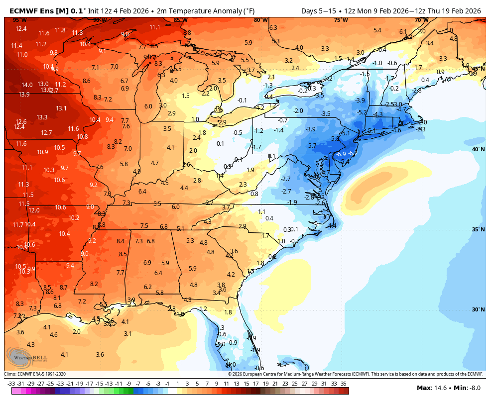
The brief return to freezing temperatures hasn't been all that impressive. From the point where we went below freezing at 7pm on January 23, we were consecutively below freezing for 234 hours ending at 12:45 PM on Monday. Through now, there have been 9.5 hours out of the past 293 that have been at or above freezing with a maximum temperature of 34° : Monday 2/2 Above freezing from 12:45 - 4:50 pm (4 hours 5 minutes) - max temp 34° Tuesday 2/3 Above freezing 10:15 to 11:00am and 1:30 - 1:45 pm (1 hour total) - max temp 33° Today 2/4 Above freezing 11:10am - 3:30 pm (4 hours 20 minutes total) - max temp 34° Current temperature is 31.6° (3:58pm)
-

February 2026 Medium/ Long Range Discussion: Buckle Up!
SomeguyfromTakomaPark replied to Weather Will's topic in Mid Atlantic
The EPS hasn't been amazing this season IMO. I'll take a blend of everything at 10 days and not even focus on one model suite. -

February 2026 Medium/ Long Range Discussion: Buckle Up!
Chris78 replied to Weather Will's topic in Mid Atlantic
I'm kind of surprised how awful the eps snow mean is for next weekend. A little deflating -

2025-2026 Fall/Winter Mountain Thread
Tyler Penland replied to Buckethead's topic in Southeastern States
Dumping snow here in Blowing Rock now Sent from my Pixel 10 Pro using Tapatalk -

Friday February 6 FROPA / WINDEX small event
Kitz Craver replied to HoarfrostHubb's topic in New England
We 18z Nam -

Winter 2025-26 Short Range Discussion
sbnwx85 replied to SchaumburgStormer's topic in Lakes/Ohio Valley
Duster incoming tomorrow. Followed by a DAB+ Friday. Lake effect looks paltry before another DAB+ Sunday. Stacking DABs -

Pittsburgh/Western PA WINTER ‘25/‘26
MikeB_01 replied to Burghblizz's topic in Upstate New York/Pennsylvania
10 days haha Here we go again. Time to reel in another big one -

Pittsburgh/Western PA WINTER ‘25/‘26
colonel717 replied to Burghblizz's topic in Upstate New York/Pennsylvania
I kind of wish the models waited until Day 4 to show something. I was doing so good with sleep and not watching 0z models as they came out. Now they are sucking me in... -
The wind reversal prospects are dropping off quickly. I’m starting to think there actually may not end up not being a major SSWE and an SPV split like @so_whats_happening has been musing….
-

E PA/NJ/DE Winter 2025-26 Obs/Discussion
Birds~69 replied to LVblizzard's topic in Philadelphia Region
32F/Sunny, expected low 5F Nockamixon Feb 1st (Facebook) t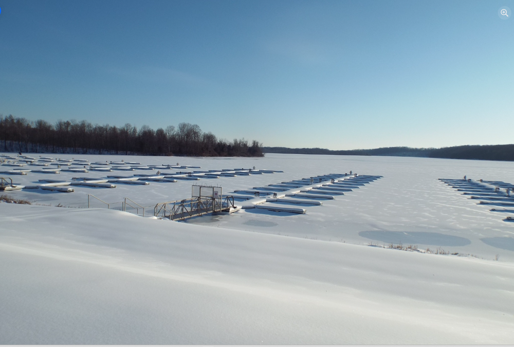
-

February 2026 Medium/ Long Range Discussion: Buckle Up!
Jake Wx replied to Weather Will's topic in Mid Atlantic
yea... were not torching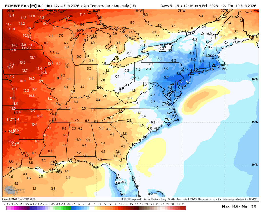
-
Pittsburgh/Western PA WINTER ‘25/‘26
colonel717 replied to Burghblizz's topic in Upstate New York/Pennsylvania
KEY MESSAGE 1... An Alberta Clipper will track through the Great Lakes and bring another round of snow to the region Friday morning into early Saturday. In general, forecast values across the lowlands average around 2.5 inches, with localized areas measuring as high as 4 inches. Peak times for snow accumulation still look to be between 10am and 5pm, which will likely impact the Friday evening commute. There is very little uncertainty about the snow type; it is expected to be light, fluffy snow, with snow-liquid ratios ranging from 18:1 to 21:1. Higher amounts are likely in the ridges with enhanced rate due to upsloping. 3 to 6 inches are currently expected with locally higher amounts possible. Blizzard conditions are also possible given the character of the snow and eventual wind gusts up to 45mph. In coordination with surrounding offices, a Winter Storm Watch was issued for the ridges of WV and PA. In the evening, an advancing cold front may result in another period of increased snow rates, and possibly snow squalls. Be prepared for rapidly crashing temperatures into the single digits, gusty winds, and low visibility if snow squalls develop. -
I remember reading about the Jan thaw getting muted too and it ended up +10 over a 10 day stretch. But sure, the cold has won out in the extended more often than not for the first 2/3 of winter. But I don’t think many have been predicting toucans and stunned iguanas. It’s more just a relaxation of the pattern with more snow/ptype threats and more fair weather days above freezing given the latitude gain of the temp gradient.
-
Feb 4-5 significant SE snow threat
WinstonSalemArlington replied to GaWx's topic in Southeastern States
-
2/7, 2/12, 2/15 Can we bat .667? I'd like to hit on at least one of the latter two, having the higher upside.
-
It has some support now.... Euro AI made a huge step south and has a 2 to 3 inch snow mean across NC at day 9.
-
Fair point, lol
-

February 2026 Medium/ Long Range Discussion: Buckle Up!
GreyHat replied to Weather Will's topic in Mid Atlantic
12z GFS says give it to NC/VA again as the HP suppresses it down. Neat to see all the different outcomes. Different model 12z runs show 2m temps warm with the exception of Euro and GFS. I also notice the 850mb level is warm on all 12z models, the 700mb level is cold on all 12z model runs.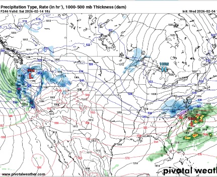
-

Is we back? February discussion thread
Damage In Tolland replied to mahk_webstah's topic in New England
Saturday Wednesday Vday -
Nope, just keeping it real: what’s good for one is good for all.