All Activity
- Past hour
-

Central PA Fall Discussions and Obs
Blizzard of 93 replied to ChescoWx's topic in Upstate New York/Pennsylvania
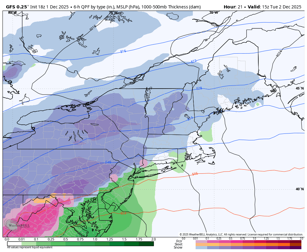
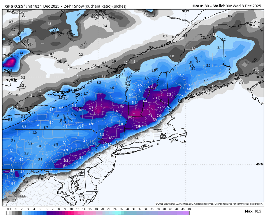
CTP with a very detailed forecast here : SHORT TERM /3 AM TUESDAY MORNING THROUGH TUESDAY NIGHT/... Quick moving storm to bring the first widespread plowable snowfall of the season to central PA early Tuesday. The snow accumulation will result in travel impacts and disruptions for the Tuesday morning commute to work and school. Key Takeaways/Messages: *Snow onset 3-6AM window from west to east (give or take 1hr) with temps cold enough to support accumulation and deteriorating road conditions *Heaviest snow 5-10AM west to 7AM-12PM east with rates generally <1 in/hr (0.50-0.75" range) *Snow end time 10AM-2PM west to east; snow showers or flurries linger through the evening downwind of Lake Erie over the western Alleghenies and Laurel Highlands *Total snowfall in the 2-4/3-5" range for most of the area; exceptions are the far southeast (lower amounts 0.5-2") due to rain/wintry mix and the Coal region into the Poconos (higher amounts 4-6") *Sullivan County has the highest probability (50-70%) of localized snowfall >6" *Snow character will initially be on the dry side with temps in the 20s but trend wetter/slushy as temps rise near/above freezing by the early afternoon *No significant wind impacts expected with this system; winds will increase early Tuesday night with gusts up to 20 mph We are most confident in a widespread moderate to high end winter wx advisory scenario given the fast moving nature of the system. We anticipate the highest snowfall totals over the northeast to east-central quadrant of the CWA or to the east of US-15 and north of I-81/I-78. Any melted snow or slush will refreeze Tuesday night with low temps in the lower 20s. -

First Winter Storm to kickoff 2025-26 Winter season
mreaves replied to Baroclinic Zone's topic in New England
I just noticed that you doubled your elevation at the new house compared to pit 2 in Maine. Congrats! -
https://x.com/nypost/status/1995555955707117813?s=46
-
We just can’t buck this years long trend of fast flow northern stream dominance can we?
-

December 2025 regional war/obs/disco thread
RUNNAWAYICEBERG replied to Torch Tiger's topic in New England
The never ending forecasting dilemma. -

Winter 2025-26 Medium/Long Range Discussion
ChiTownSnow replied to michsnowfreak's topic in Lakes/Ohio Valley
Clipper fest.. not sure if these are considered clippers but either way, let's keep it white till Christmas -

First Winter Storm to kickoff 2025-26 Winter season
HoarfrostHubb replied to Baroclinic Zone's topic in New England
Worcester Public closed. That’s a bit early I get it. Helps parents sort out child care etc. Also, my Wunderground app seems to be bringing in accumulating snow kind of early. Like 9AM. That seems off -
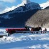
Clear skies at dusk. 33/23
-
Central PA Fall Discussions and Obs
Blizzard of 93 replied to ChescoWx's topic in Upstate New York/Pennsylvania
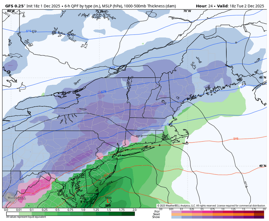
CTP : SYNOPSIS... * The first widespread plowable snowfall of the season will cause travel impacts and disruptions early Tuesday * Arctic cold front will deliver snow showers/squalls and bitter cold temperatures Thursday through Friday morning * Reinforcing cold blast will ensure the first part of December will be colder than the historical average with the potential for another storm system this weekend or early next week -
Hopefully more next spring in northeast MD!
-
34 degrees 24 dp in my backyard in Owings Mills
-
 Went from a Winter Storm Watch for 7"+ over to a Winter Weather Advisory for 2" - 6" Im figuring maybe 3" if I am lucky.
 -
You'd think just from dumb luck we'd stumble into a storm one of these days....
-
I forsee a Meteorologist tag next to your username soon.
-
Awesome, UVA is a great school and really nice to have the in state price. You’re doing great with your met analyses! Keep it up.
-
Yep! Graduation out of the Oakton area last year and honestly you can't beat UVA for the in-state price. Though, luckily I have both Amtrak and a car for my traveling needs if Nova can finally reel in the big one someday. I'm also an env sci major and am taking their Atmosphere and Weather class (which usurpingly I've quite enjoyed and will be taking Synoptic meteorology in the 2027 when it is offered) which has helped me construct the far longer (and hopefully useful) posts I've been able to make in the long range threads. Its always been awesome having Mets like you post the dynamics behind storms so as I try to learn actual meteorology please let me know if I'm on the right track with my analyses.
-

First Winter Storm to kickoff 2025-26 Winter season
powderfreak replied to Baroclinic Zone's topic in New England
The bottom is falling out up here as soon as the sun went down. Feels like it’ll be single digits in like two hours. 19/8 and cratering. I was thinking a nice cold night could help the battle zones. -
Yeah not surprised by the choice. I also expect others to follow suit
-
18z GFS gets the precip in to late. The cold is gone taken verbatim for the Friday storm.
-
Central PA Fall Discussions and Obs
Blizzard of 93 replied to ChescoWx's topic in Upstate New York/Pennsylvania
The 18z GFS says hello!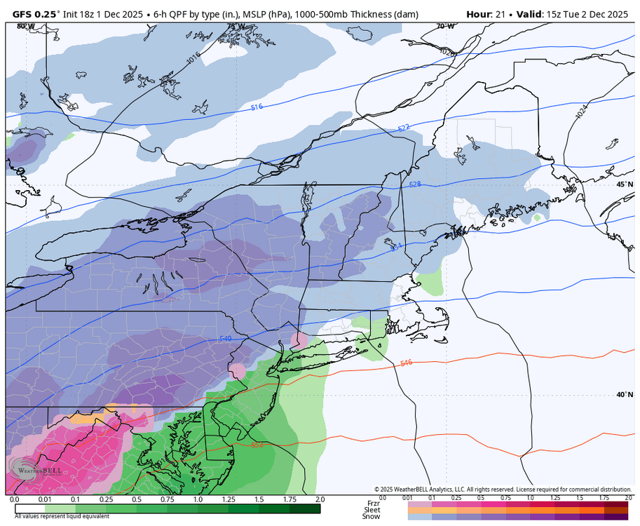
-

December 2025 OBS and Discussion
coastalplainsnowman replied to wdrag's topic in New York City Metro
So you're tellin' me there's a chance? -
43.5 for the high 42 at 4pm 39.5 at 5pm
-

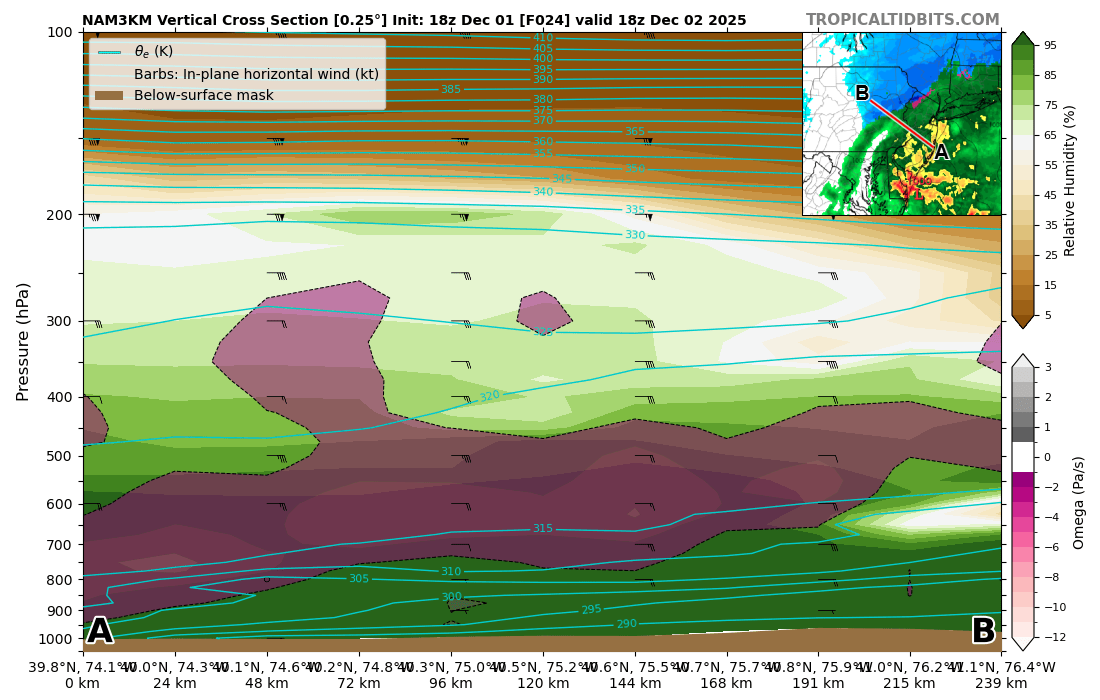
12/3 Snow/Sleet/Mix Bag of Everything Discussion/OBS
Newman replied to Mikeymac5306's topic in Philadelphia Region
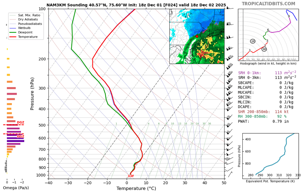
3k actually never gets KABE above freezing at 850s (though it's close), but does sneak to 33 at 925 down to the surface. At 1-2pm tomorrow, the 3k shows rain BUT some deep lift just below the DGZ and even stretching into the DGZ. The DGZ is pretty high up in the atmosphere, but as you can see in the skew-T the sounding is marginally above freezing. If you can get some deep lift and rates to increase within a backside band as the storm departs, you could potentially finish with some heavy snow and fat dendrites if the column cools isothermally back to freezing. Of course, all of this could be for nothing and if 1.) The mesos are correctly handling temperatures and 2.) The rates aren't heavy enough to cool the column then we'll definitely see the lower end of snow totals materialize. Just wanted to point out a way that you could potentially see higher end (3-4" totals) materialize along the I-78 corridor which is currently the 90 percentile from the NWS.
-
Central PA Fall Discussions and Obs
Blizzard of 93 replied to ChescoWx's topic in Upstate New York/Pennsylvania
I’ll be sleeping because it is not supposed to start until closer to 6 am, Lol! -
Ya think!