All Activity
- Past hour
-
Graf was correct again!!!!!! The NWS promised a 60% likelihood of storms. SPC issued a Severe Watch. Graf said partly cloudy with a 15% chance of any rain............ I have had 3 sprinkles. Graf is proving itself as a very credible source of information. This cannot be denied.
-

2026-2027 Record-breaking El Nino
jaxjagman replied to Stormchaserchuck1's topic in Weather Forecasting and Discussion
The warmth the past couple weeks in 1.2 tops the 82-97,pretty impressive either way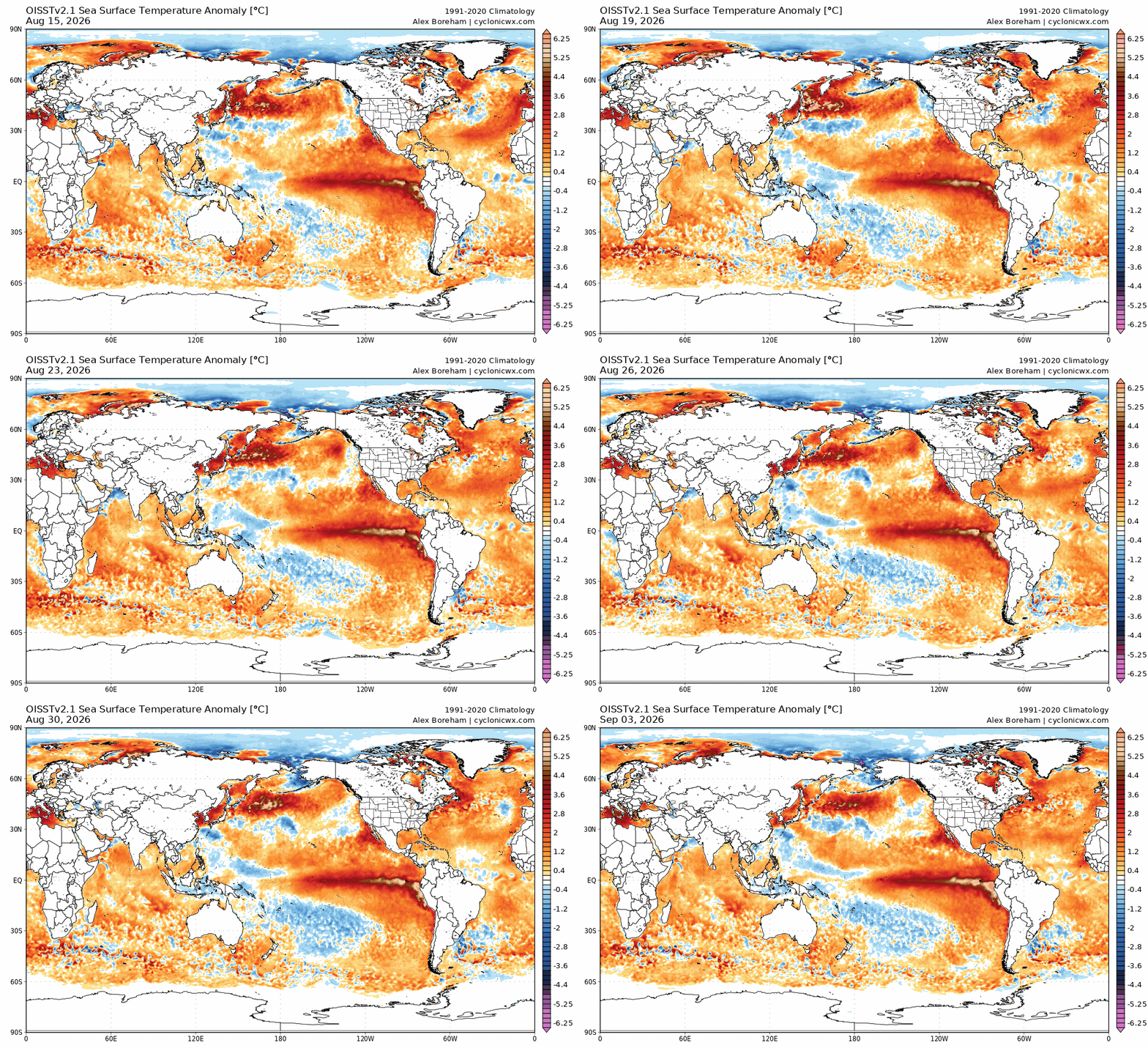
-
97
-

2026 Mid-Atlantic Severe Storm General Discussion
dailylurker replied to Kmlwx's topic in Mid Atlantic
I missed everything to the north until last evening when I started missing everything to the sw. At least I got to see flases of distance lightning last night lol -

2026-2027 Record-breaking El Nino
EasternLI replied to Stormchaserchuck1's topic in Weather Forecasting and Discussion
On the latest 30 day means of VP 200 anomalies. I see only one other event even remotely comparable to this one. 97-98 and this one looks like a beast next to that even. Super impressive stuff. I mean just look at this thing... -
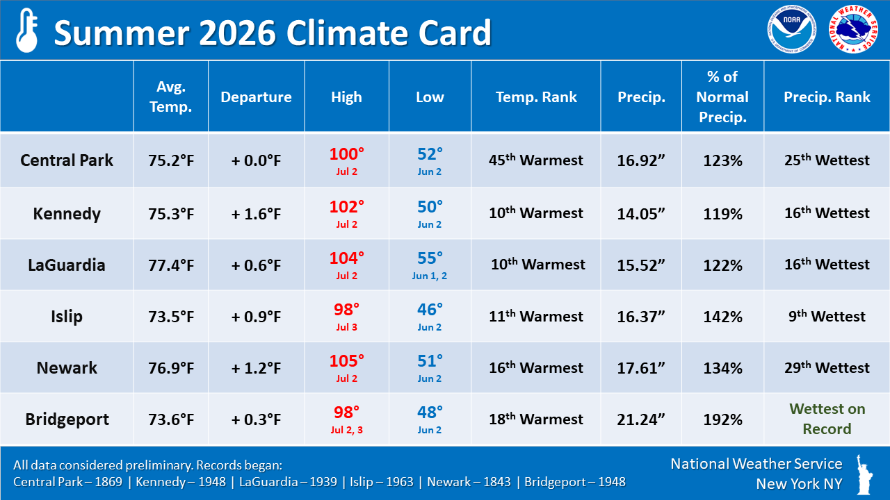
https://www.weather.gov/okx/climatecard Above summer stats locally.
-
As bad as a hurricane hitting the southeast can be, without them the southeast does not get enough precipitation.
-

2026-2027 Record-breaking El Nino
forkyfork replied to Stormchaserchuck1's topic in Weather Forecasting and Discussion
that's the most effort you people deserve -
88.8 today nice one.
-
The only given this winter is that Hubba Hubba Dave and I Need Frozen will somehow manage above normal snow in a Super Duper El Niño. All kidding aside, I do believe there will be a sharp gradient this winter, where you and I at least hit average. I think the interior has some potential to cash in on marginal events. In other words, I don’t think it’s a full dumpster fire N of RT 2.
- Today
-
Sunday weather looks amazing.
-
2026-2027 Record-breaking El Nino
EasternLI replied to Stormchaserchuck1's topic in Weather Forecasting and Discussion
After falling back somewhat, albeit much less than earlier forecasts were advertising. Seemingly due to some -MT activity mostly. The next +AAM uptick is now imminent and from an already very elevated level (>+2). Likely achieving a new high for this event (>+3). This time, it seems poised to more readily affect the NH than any other time over the summer. So that will be interesting to see how that plays out and how it verifies. Right on time it feels like, to me, as we start heading through MET autumn but let's see how it goes. -
.thumb.jpg.6a4895b2a43f87359e4e7d04a6fa0d14.jpg)
Central PA Summer 2026 Discussion/Obs Thread
Yardstickgozinya replied to Voyager's topic in Upstate New York/Pennsylvania
Unless something happens tonight, I never did end up under a core of any cell over the course of the last several days. -

2026 Mid-Atlantic Severe Storm General Discussion
SolidIcewx replied to Kmlwx's topic in Mid Atlantic
With the damage in the southern half of PG, they could use to sit this one out. (I work Utility) -
Good storm in Burke again. This one is training over me. Had two big CTG lightning strikes while hanging on the porch. First was less than 200 yards away. The other was about 1/4 mile away.
- 2,557 replies
-
- 4
-

-
- severe
- thunderstorms
- (and 7 more)
-
Thanks Don I'll be 53!
-

Monday, August 31 - Thursday, September 3, 2026 Convective Episodes
klw replied to weatherwiz's topic in New England
That image looks like the board in a game of Risk as you realize you have no chance to fend off an attack from the Eastern US into Quebec. -
The problem with those 95 degree plus highs is they were isolated to the first half of summer. Summer ended after July 15th. I'm trying to find a winter equivalent for this- not even 2010-11 compares because it lasted until the end of January (the winter equivalent of July.) This was more like a winter that ended after January 15th. As far as el nino summers are concerned 1963, 1991 and 2002 were superior in longevity. This was more like 1994. The winter will also probably be more like 1994-95 than the winters that followed those longer summers. Thanks for the Happy Birthday Chris I had two deer visitors today who came right to my kitchen windows and I took pictures which I want to share but I have a 178 kb limit for sharing images how can I lift that limit?
-
A few areas could see an evening shower. Most of the region will remain dry. Cooler air will move in overnight. A cooler air mass will cover the region for the Labor Day weekend. In its wake, temperatures will generally peak in the middle and upper 70s. Readings in New York City could fall into the lower 60s with widespread 50s outside the City. The cool weather will likely continue through at least the middle of next week. The ENSO Region 1+2 anomaly was +4.2°C and the Region 3.4 anomaly was +2.6°C for the week centered around August 26. For the past six weeks, the ENSO Region 1+2 anomaly has averaged +3.93°C and the ENSO Region 3.4 anomaly has averaged +2.50°C. The ongoing strong El Niño, which has reached super El Niño threshold, will continue to strengthen through the summer. The SOI was -7.78 today. The preliminary Arctic Oscillation (AO) was +0.293 today.
-
I think there was around 5,000 tons of explosives used just from Sideling Hill to Martin’s Mt over a 5-year period. i spent a lot of time in that area as a kid, visiting family in Beans Cove, Rainsburg and Clearville.
-

2026 Atlantic Hurricane Season
Stormchaserchuck1 replied to Stormchaserchuck1's topic in Tropical Headquarters
-

2026 Atlantic Hurricane Season
LongBeachSurfFreak replied to Stormchaserchuck1's topic in Tropical Headquarters
Yeah it’s a major bummer for me. I was at least hoping for some development in the subtropics where sea surface temps are still above normal. On to tracking non tropical systems coming up the coast with a juiced STJ. This fall/winter likely includes major coastal impacts up the east coast. The outer banks may be in serious trouble . -
The most annoying thing is the FCC over regulation requiring local TV stations to keep broadcasting weather while a tornado warning is ongoing. There was one here that lasted for 3 hours and the TV mets ran out of things to say. This FCC over regulation needs to come to an end. Instead they should regulate the amount of commercial time allowed to TV stations to 5 minutes per 30 minute period. I understand a 5 minute update and a crawling scroll at the bottom of the screen with a radar inset, But 3 hours for a tornado warning that probably didn't even contain a real tornado? HELL NO How many of these tornado warnings contain real tornados? Not doppler funnel clouds? I propose we limit tornado warnings to only real verified on the ground tornados and doppler funnel clouds can be given tornado advisories or funnel cloud warnings or whatever. And if you think this is a trivial issue, an Atlanta TV station was given death threats for interrupting the Masters because of tornados that day. 5 minutes of coverage every hour is enough and a scrolling crawl at the bottom of the screen with a radar inset. Or maybe allow each state to handle it separately tornados are much more of a danger in other parts of the country.
-
2026 C and E Pacific tropical activity
LongBeachSurfFreak replied to GaWx's topic in Tropical Headquarters
Kauai is really going to luck out here. This could easily rival Iniki if it were slightly further east on the recurve .