All Activity
- Past hour
-
 Decent snow growth now. Driving around and man the piles are huge. There was some QPF in the snow. This was a great storm. Cars are just buried.
 -

MO/KS/AR/OK 2025-2026 Winter Discussion
lookingnorth replied to stormdragonwx's topic in Central/Western States
The storm total was about 6.5" in Norman. That's less than I was hoping for, but I kind of expected it to underperform somehow. Plus, it was still the biggest snowstorm I've personally experienced since January 2010 in NC, so I can't complain. I like how it's supposed to be cold the next few days, so while I'm sure it will melt a good bit in the sun, melting should be slower than it is after some storms. -
This would be how many times in a supposed La Niña that the 757 has gotten a major snowstorm that misses Richmond to the south? [emoji28] .
-
The Euro family is still by far the best model family available.
-
That's real nice for 5 days out!!
-
Picked up a general 1 to 2 inches after the last obs that I posted last night. Measuring this was a nightmare with the wind. I'll call it 15.0" total all said and done. Seeing two 20.0" reports just to my east near Lake Wallenpaupack. I guess it's possible. Great storm!
-
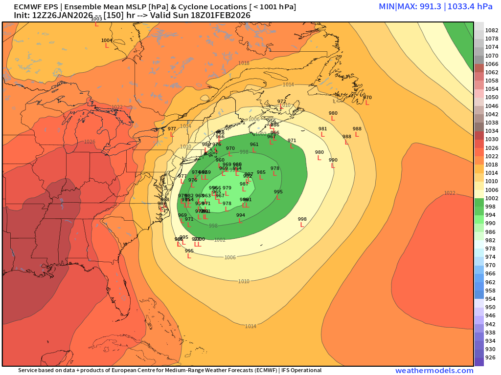
Exactly my (albeit uneducated) thoughts. Seems like the SLP mean is being dragged by some outliers east. That’s a lot of lows hugging the coast. Not sure we can reasonably ask for anything else at this point.
-

E PA/NJ/DE Winter 2025-26 Obs/Discussion
hazwoper replied to LVblizzard's topic in Philadelphia Region
Yeah, but it is a pretty massive spread. Plenty of time. -
 Seems like they’re going to keep coming every few days / week
 -

Central PA Winter 25/26 Discussion and Obs
pawatch replied to MAG5035's topic in Upstate New York/Pennsylvania
Storm total 10” I have 300’ of drive I cleared 4 times with a snowblower during the storm. Finished cleaning everything up at 11:00 am this morning. Send the next one -
I'm not at all surprised at the 12z Euro. I posted at 7 am that I was not enthusiastic about the EURO. But, the GEM, GEPS, GEFS and GFS all shifted toward snow. I'm honestly not enthralled with the deterministic Euro after it insisted run after run last weekend that I would receive .80 - .90" of freezing rain. I received .01" freezing rain. Total failure. And, the Euro AI ensemble gave me 15.5" to 16.5" of snow for 24 hrs. pre event Friday/Saturday. I received 3 inches of snow and 3 inches of sleet. The Euro family needs improvement to regain credibility with anyone paying close attention.
-
You would have loved February 5, 1978, the great northeast blizzard of 1978. Did a loop. I got 18 inches, here.
-

Richmond Metro/Hampton Roads Area Discussion
Avid6eek replied to RIC Airport's topic in Mid Atlantic
I'm happy with where things are today. If I could lock in the 12z GFS blizzard-cane I would. Hopefully this week's cold weather will cool the coastal waters down enough to put us in an even better position when the time comes. I'd much rather have a howling N wind off a 32'ish degree Chesapeake Bay than the current 40'ish degree bay.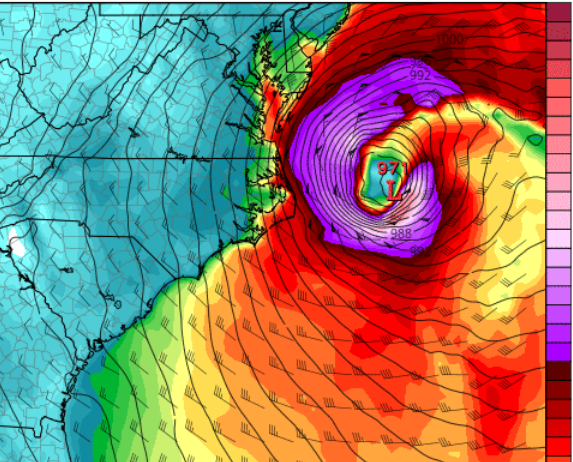
-
There was a time where this would always tick west. What do yall think? Can we bring back that reality?
-
As expected nice gap on vis along I-80. I'd post image but I'm at work lol.
-
There are some members way east but seems the th biggest cluster is on the coast.
-

The “I bring the mojo” Jan 30-Feb 1 potential winter storm
Ravens94 replied to lilj4425's topic in Southeastern States
The talk of 1980 500mb charts are really similar to this setup. Just need a bombing low off GA https://www.weather.gov/mhx/Mar011980EventReview -
So as we can see, there are 3 main scenarios/clusters - 1) way OTS fish storms, no one gets anything except maybe cape cod gets clipped, 2) storm tracks from OBX NNE with some tucks/scrapers, 3) miller B esque storms bombing out too late for us.
-
Per NOAA, CP ended the day with 1.82 inches.
-
The following evolution looks reasonable to be. Both the 12z GEPS-par and 12z Euro are very similar. The Euro was missing some juice. The 12z GFS, Euro, and GEPS-para are slightly west of their previous positions with the slp. Below is a 12z comparison (not comparing to 6z runs) of the GEPS-para and Euro. Left is GEFS-para and right is Euro. Generally, that is pretty good agreement for low placement. Per the GEPS-para, I tend to think the northern stream system will be stronger over the eastern Tenn Valley than the Euro has. The Euro tends to be a little biased towards drier systems. The GEPS-para was the first to nail mixing issues over NE TN with this last system. Can it trend west to northwest? Sure, but that is a tighter window with each passing run.
-
Upton with 20- 30 percent chance of 6 inches or more https://mesonet.agron.iastate.edu/wx/afos/p.php?pil=AFDOKX&e=202601261832 Deterministic and ensemble models show a piece of energy breaking off the polar vortex and shifting into the Southeast this weekend before lifting off the Mid-Atlantic coast. This would then help develop a surface low emerging off the Carolina coast during Saturday and strengthen the storm as it heads northeast, perhaps approaching the 40N/70W benchmark at some point Sunday or Sunday night. Did not deviate from NBM PoPs (20-30%) from Saturday night through Sunday night. Too early to have much confidence with the probability of occurrence and certainly with any details of the storm this many days away. With that said, NBM shows a 20-30% chance of at least 6 inches of snow across the area for the event. Additionally, there is at least moderate to high confidence that temperatures would be cold enough to support snow at the start of the event.
-

Pittsburgh/Western PA WINTER ‘25/‘26
MikeB_01 replied to Burghblizz's topic in Upstate New York/Pennsylvania
so you're saying theres a chance... -
All the folks saying "I'd rather this be east" and "we don't wanna be in the bullseye this far out" and "right where we want it" are very much off base here, imo. This is a very very different type of storm than the one we just had - it's not a huge storm banging into a cold airmass from the southwest. Synoptically, there is a pretty razor thin margin for this thing to amplify and go negative quickly enough to become the coastal crawling monster we want it to be. The whole trough is WAY too east for anything else to work. The blizzard scenario for us is already at the far western end of the envelope of realistic possibilities. There's no way this cuts or goes west of us, it's essentially meteorologically impossible for it to do so. We want every run to be crushing us - because there's a pretty thin line between a big storm for us and something OTS or a Hatteras/Cape Cod scraper or New England recurve bender, and every run that comes in on the wrong side of that line reduces the chances that something magic happens for us.
-

Possible coastal storm centered on Feb 1 2026.
dryslot replied to Typhoon Tip's topic in New England
Some better clustering with the members that are west of the mean.
-
Can you post the 6z for comparison?