All Activity
- Past hour
-

January 25/26 Jimbo Back Surgery Storm
WinstonSalemArlington replied to Jimbo!'s topic in Southeastern States
As far northeast as Roanoke -
Can we stop with the stupid Kuchera maps?
-

2025-2026 Fall/Winter Mountain Thread
Maggie Valley Steve replied to Buckethead's topic in Southeastern States
Light snow at the Top of Cataloochee. -

January 25/26 Jimbo Back Surgery Storm
Brick Tamland replied to Jimbo!'s topic in Southeastern States
-

1/24-1/25 Major Winter Storm - S. IL, IN, and OH
Frog Town replied to A-L-E-K's topic in Lakes/Ohio Valley
Nice trends overnight! This is all because MI was removed from the thread. Mother Nature's humor.. -

“Cory’s in LA! Let’s MECS!” Jan. 24-26 Disco
Go Kart Mozart replied to TheSnowman's topic in New England
That's an interesting point. When I look at the soundings in the regions depicted as sleet on the maps, I see the only violation of 0c is the narrow nose right at 700mb. In reality, I wonder if it is sleet mixed with snow that forms below 700mb? -

January 24-26: Miracle or Mirage JV/Banter Thread!
Bubbler86 replied to SnowenOutThere's topic in Mid Atlantic
I have some neighbors who had power/electric bills over $700 last bill....the previous years they are $200-$300. Kwh went from 7-8 cents to 12-13. -

Let’s talk winter!! Ohio and surrounding states!! 24'-25'
pondo1000 replied to buckeye's topic in Lakes/Ohio Valley
There may have been one of 10+ since then but it wasn’t memorable. -

Central PA Winter 25/26 Discussion and Obs
Mount Joy Snowman replied to MAG5035's topic in Upstate New York/Pennsylvania
Low of 5. It's wild with these temps that (1) we have a major snowstorm even happening at all and (2) some of us have to worry about mixing. Hi-res models seem to be all over the place with the extent of the sleet. Today's 12z runs crucial, starting with the HRRR which is firing as we speak. Let's do this. -
January 24-26: Miracle or Mirage JV/Banter Thread!
Bubbler86 replied to SnowenOutThere's topic in Mid Atlantic
Organic Fowl looks pretty well stocked. 'Roids for everyone. -

Jan 24-26 Weekend Snow and Sleetfest Model Thread Part Tres
mitchnick replied to H2O's topic in Mid Atlantic
Flow right out of the eastern equatorial Pacific. https://www.ssec.wisc.edu/data/us_comp/large -
Temp on the rise From 10F to 12F -9
-

Extreme Cold, Snow & Sleet: SECS 1/25 - 1/26
weathermedic replied to TriPol's topic in New York City Metro
Good write up (as usual) with the morning AFD out of Upton: A major winter storm will impact the region Sunday into at least early Monday. A Winter Storm Warning Remains in effect for the entire area. Arctic air has settled over the area courtesy of a sprawling 1048 mb high pressure over the northern plains. This high pressure will settle over New England tonight as a winter storm materializes over the southeastern US. Low pressure will develop over the south and be forced to track around the deep cold air damming signature east of the Appalachians tonight, with secondary low development taking place along the Middle Atlantic coast on Sunday. This low pressure will then deepen as it tracks towards the Long Island coast late Sunday into Sunday night before shifting offshore on Monday. The main uncertainty with the system continues to revolve around the timing of potential mixing with sleet for the southern/coastal portion of the region Sunday evening. The model guidance is in overall agreement on the key pieces with the winter storm, but differ slightly on the northward extent and timing of a warm nose around 750 mb. Generally took a blend of partial thicknesses from the GFS, ECMWF, NAM, and RGEM Sunday evening. Most of the guidance has settled on any potential wintry mix occurring around or just after 00z Monday. The NAM is the most aggressive and quickest with the warm nose (sometime mid to late afternoon) and wanted to at least blend its thicknesses in case the warm nose comes in a bit faster than currently expected, which has happened in past events. Snow will quickly develop from south to north across the area Sunday morning as the region lies underneath an intense polar jet streak lifting into southeast Canada. The snow will fall into arctic air with surface temperatures only in the low to mid teens. This is a bit unusual for the area as most snow events over the Tri-State occur with temperatures in the 20s or low 30s. The snow will quickly accumulate as the intensity picks up through the morning. Mid level thermal forcing will increase over the area, especially heading into the afternoon. The 850-700 mb frontogenesis is impressive and the overall deep layer of vertical velocities over the area strongly support heavy snow over the region in the afternoon. Only a slight increase in temperatures is expected in the afternoon, except the southern half of the area where temperatures rise into the mid 20s. As the warming in the middle levels continues, the chance for a mix with sleet near the coast increase sometime late in the afternoon or evening. It needs to be emphasized that the overall impacts will not change and significant snow will occur before any wintry mix. There is a possibility the heavy snowfall rates will be able to hold back the warm nose just enough or create an isothermal layer on the 0C isotherm to prolong heavy snow for even just an hour two. The 00z HREF indicated several hours of over a 60 percent chance of greater than 1 inch per hour rates, and even has a few hours over 80 percent. The probability for greater than 2 inches per hour on the HREF in the afternoon/early evening ranges from 20 to 40 percent. The guidance also offers impressive QPF values between 18z Sunday and 00z Monday with potential of at least a half inch liquid, giving more confidence there will be heavy snowfall over the area. A few lightning strikes cannot be ruled out in the heaviest bands with the impressive dynamics aloft and deep moisture being lifted over the low level arctic air. The strong mid level frontogenesis lifts northeast between 00-06z Monday and this should serve to gradually reduce precip rates. There may also be drying aloft, which will start to reduce snowfall rates where it remains all snow. The southern half of the area should see a wintry mix of sleet, potentially mixed with snow if the warm nose is not as deep. There is also a chance for some light freezing rain and a light glaze of ice as the drying aloft occurs, cutting off snow growth along with the thinning of the depth of the low level cold air. This may also be dependent on how close the low pressure ends up to Long Island. The consensus of the modeling keeps the low just south and east of Long Island, but if it were to end up closer to the shore, some parts of eastern Long Island could briefly rise above freezing with light plain rain briefly possible. The system starts pulling away from the area late Sunday night into Monday morning. Some bands of light snow may return as the trailing upper trough approaches and the thermal profiles become colder heading into Monday. Probabilities for precip decrease significantly Monday afternoon and there is potential anything that falls may just be flurries. Snowfall totals are largely consistent with the previous forecast ranging from around 10 inches near the coast and around 16 inches well inland. The potential of sleet is included in these totals for areas that may see a mix or a full changeover. SLRs are tricky with this event as the arctic air mass supports a higher ratio (around or just above 15:1), especially early in the event. The increasing moisture aloft and warmer air in the middle levels will likely lower ratios to 12-14:1 and will drop further with any mixing in the evening towards the coast. As noted above, snowfall rates of 1-2 inches per hour are expected in the afternoon and early evening. Winds will pick up in the afternoon and evening, especially near the coast and could create near white-out conditions/near blizzard conditions with winds gusting 30 to 40 mph at times. A mix or change to sleet will reduce this potential as visibilities would not be as low. -

Southern Crippler - Get well soon Jimbo Storm Obs
DTP replied to BooneWX's topic in Southeastern States
35/15 in Tega Cay-7 mi south of KCLT Decent 7-10 mph 020 breeze out there.. sky back to the west is overcast...be interested to see the low lvl deck as it gets closer- CAD plus a strong warm nose throws out some really oddball distinctive cloud patterns at lower levels -

Central PA Winter 25/26 Discussion and Obs
Blizzard of 93 replied to MAG5035's topic in Upstate New York/Pennsylvania
High res Canadian short range “Herpaderp” looking good too, lol!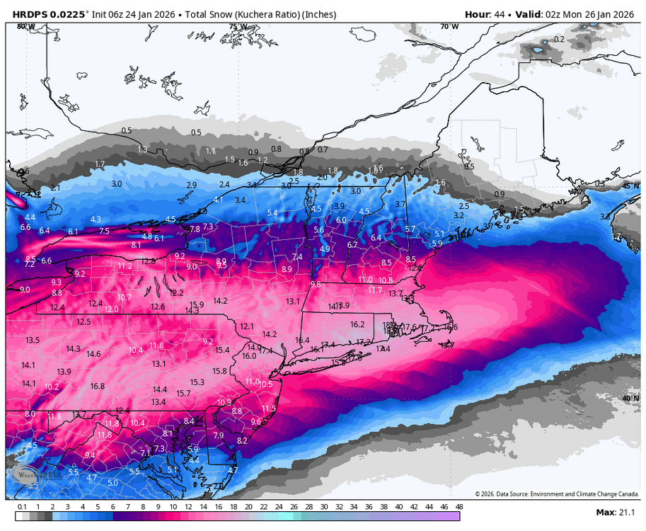
-

Pittsburgh/Western PA WINTER ‘25/‘26
MikeB_01 replied to Burghblizz's topic in Upstate New York/Pennsylvania
Merry Christmas Eve, everyone. . -

Arctic Hounds Unleashed: Long Duration Late January Cold Snap
WxWatcher007 replied to WxWatcher007's topic in New England
KART -35 ob with -53 WC Watertown always delivers. -
 Snow falling in south west Tn. 1-2 inches so far by the looks of it.
 -

Jan 24-26 Weekend Snow and Sleetfest Model Thread Part Tres
WeatherShak replied to H2O's topic in Mid Atlantic
[emoji38] I was just excited we both noticed it! His was more succinct! Cheers! -

“Cory’s in LA! Let’s MECS!” Jan. 24-26 Disco
Ginx snewx replied to TheSnowman's topic in New England
LFG 6z GFS Kuchera 6Z Euro depth.png.3286a98be7d3aab6cad600dd6792fc61.png)
.png.ae9005b1f8191388f61bd57138298696.png)
-
 28 here as well. Still hanging on to a few snowflakes, but I'm back to mostly sleet.
 -

Extreme Cold, Snow & Sleet: SECS 1/25 - 1/26
WeatherGeek2025 replied to TriPol's topic in New York City Metro
Grab a small wrench and tap it numerous times. Like actually hit it -
 Down to 28° with all snow in Ooltewah. Hoping we can hang on long enough for a dusting just to cover the grass at least. Sent from my SM-S916U using Tapatalk
 -

Arctic Hounds Unleashed: Long Duration Late January Cold Snap
ariof replied to WxWatcher007's topic in New England
Alton Bay Ice Runway (B18) should be ready once the storm passes. They're at 11" right now, and need another 1-2" to open. Once they are open this year they should be open for a while. https://www.facebook.com/AltonBaySeaplaneBaseandIceRunway/ -

Extreme Cold, Snow & Sleet: SECS 1/25 - 1/26
sussexcountyobs replied to TriPol's topic in New York City Metro
Pump is hot. My boiler guy should be here within a half hour.


