All Activity
- Past hour
-
My dad got a better view over in Wisconsin .
-

Rise of the Machines: January 18-19 Winter Storm Obs Thread
metagraphica replied to WxWatcher007's topic in New England
@The 4 Seasons 1.3" in the morning and 2.6" last night. 3.9" total. (just a trace on Saturday after sunset) -

Winter 2025-26 Short Range Discussion
WestMichigan replied to SchaumburgStormer's topic in Lakes/Ohio Valley
You got your snow last week. Time to let someone else in on the aciton -
This would actually make sense. I've been watching winter storms forecast across the mid-south turn into Kentucky maulers (80% of the time) for over 50 years now.
-

Rise of the Machines: January 18-19 Winter Storm Obs Thread
TheSnowman replied to WxWatcher007's topic in New England
Holy Crap!! I Almost Jacked!! I ALMOST Jacked!! 7"!! MOST SNOW I’ve Seen since February of 2022! And of COURSE I was Home almost 2 1/2 Months just waiting for Snow, get Screwed like I’ve never been screwed time after time, and Now I LEAVE to LA Tomorrow! Can Only Enjoy 36 Hours of this. WTF. 15.25” Season. -
@high risk would have a better explanation, but usually if the models are struggling with surface temps while everything else looks normal, it is something to do with how they are implementing approximations via a boundary layer scheme. Global and regional models simply can't calculate everything, so you effectively end up with little "models" inside of models. Models have always struggled with how to calculate the mixing and radiative transfer near the surface in stable conditions. The Euro is handling this poorly, which is how you get a minus teens forecast for parts of Virginia next week, which is not going to happen. I think it is even struggling with temps in the pre-storm period on Saturday, given the much colder surface temps than the GFS despite only 1° difference at 925mb. I'd just be cautious with any surface temp output from the Euro right now.
-

Central PA Winter 25/26 Discussion and Obs
Superstorm replied to MAG5035's topic in Upstate New York/Pennsylvania
That weekend storm is got me licking my chops! . -

Pittsburgh/Western PA WINTER ‘25/‘26
colonel717 replied to Burghblizz's topic in Upstate New York/Pennsylvania
Nice. Barely a dusting here. -
-

E PA/NJ/DE Winter 2025-26 Obs/Discussion
Lady Di replied to LVblizzard's topic in Philadelphia Region
Is your tank outside? Heat tape on the oil line(s) might help. Mine is in the basement with the line going into the top and not all the way down. I have to watch my gauge 'cause at 1/4 I'm out. -

January 2026 Medium/Long Range Discussion
Scarlet Pimpernel replied to snowfan's topic in Mid Atlantic
You're referring to the 06Z EPS that was shown earlier? I agree. I made these comments earlier, but (1) it stops at 144-h, and I don't think that's the entire storm and (2) to me, it appeared that the max snow area actually widened or expanded. Either way, yeah, one could argue that the axis shifted a bit south but right now it's mostly noise. -

Rise of the Machines: January 18-19 Winter Storm Obs Thread
WinterWolf replied to WxWatcher007's topic in New England
@The 4 SeasonsHad 2” Saturday. 3.75” yesterday(1.25” in the morning, and 2.50”last night). -

January 2026 Medium/Long Range Discussion
NorthArlington101 replied to snowfan's topic in Mid Atlantic
I think I’m still more concerned about suppression so I think I agree with you. My scenarios are good snowstorm, whiff south and something light, and snow -> way too icy. No idea how I’d weigh each option but finding it hard to see is getting skunked -

Rise of the Machines: January 18-19 Winter Storm Obs Thread
CCHurricane replied to WxWatcher007's topic in New England
Last burst on Cape overlooking Nantucket sound ~ 9AM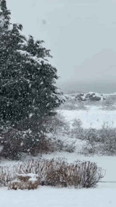
-

Rise of the Machines: January 18-19 Winter Storm Obs Thread
ineedsnow replied to WxWatcher007's topic in New England
4.25 as of now but im guessing you got the extra 1/4 in the last hour -

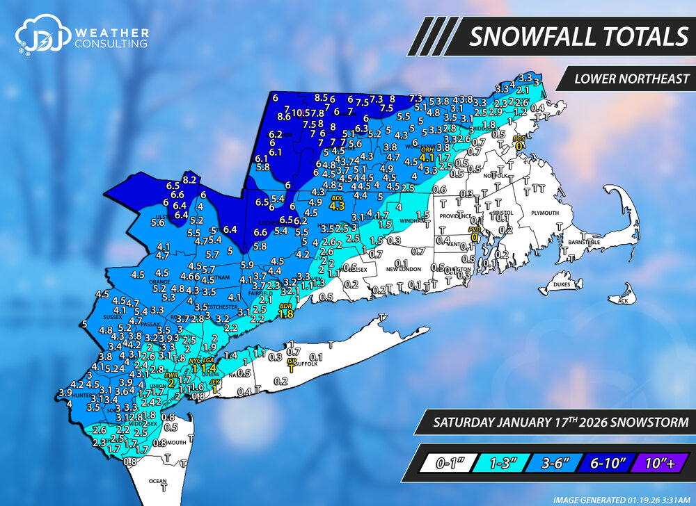
Storm potential January 17th-18th
The 4 Seasons replied to WeatherGeek2025's topic in New York City Metro
If anyone has any snowfall totals for Jan 18th ONLY, let me know, ill be doing maps for yesterdays system. These are the snowfall totals for the Jan 17th over performer. This only for the Saturday Jan 17th event Thanks to everyone who sent me reports, they were useful and i tried to include most of them if they could fit. You can always find all these maps along with CT and SNE here Lower Northeast Tri-State Area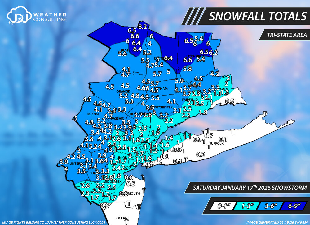
-
6z Euro was just a thing of beauty (except for the ice). How it unrolls the Baja low is almost perfect with how it has the shortwave moving through the Dakotas. There is going to be ice somewhere though. I think that is unavoidable with an overrunning setup.
-
Next 24-48 hours of model runs will be pivotal in determining what this looks like coming out. (i.e. one system vs. several smaller waves of overrunning moisture- Miller A/Miller B and what the orientation the incoming high will take on). Pretty confident a nice winter storm will scoot across, but in the mid-south there's always a chance the warm air across the gulf surges further north than modeled.
-
January 2026 Medium/Long Range Discussion
Scarlet Pimpernel replied to snowfan's topic in Mid Atlantic
I know, we've all been there, done that, have the T-shirt. Which is why I mentioned the GFS was showing that kind of scenario just the other day before it began suppressing everything, and everyone got freaked out at that. I still think currently, that's the least likely scenario...if anything I can see a snow to ice (or snow-ice-snow) outcome if this ends up going "too far" north in the end. -

Rise of the Machines: January 18-19 Winter Storm Obs Thread
HoarfrostHubb replied to WxWatcher007's topic in New England
Hubbardston MA. 4.0” Jan 18/19 -
Also, all of those happened during el ninos, with the 1966 and 2010 ones in strong el nino. Even the 1978 one had a borderline weak/moderate el nino.
-

January 2026 Short/Medium Range Thread
Weatheriscool replied to John1122's topic in Tennessee Valley
It is amazing that the Weather Channel literally has their forecasts pegged to the GFS; last night it had snow for my area Friday night Saturday and Saturday night, now, maybe an inch Friday night where before it was 1 - 3 for Friday night; 5 - 8 for Saturday, 1 - 3 for Saturday night -
Kinda just noise at this range though.
-

Rise of the Machines: January 18-19 Winter Storm Obs Thread
rimetree replied to WxWatcher007's topic in New England
Winding down. Measured 5"...not bad. -
If we do not get a MECS or two out of this pattern within the next 2 weeks there will be no explanation other than rotten luck.


