All Activity
- Past hour
-
Nope it fell apart just before reaching here, nothing but some mood drops. We blew the top off the thermometer today, topped out at 101.8!!!
-
I took mine too, but am parking in the garage later
-
Fwiw, both 16z and 17z HRRR have an MCS/line/complex come rolling through the region between midnight and 3am. 17z HRRR encompasses more of the region than the 16z run did. Not saying its severe, just something to think about overnight as we watch it develop out to our NW ETA - 18z HRRR same idea... but an hour or so faster
-
Up to 87
-

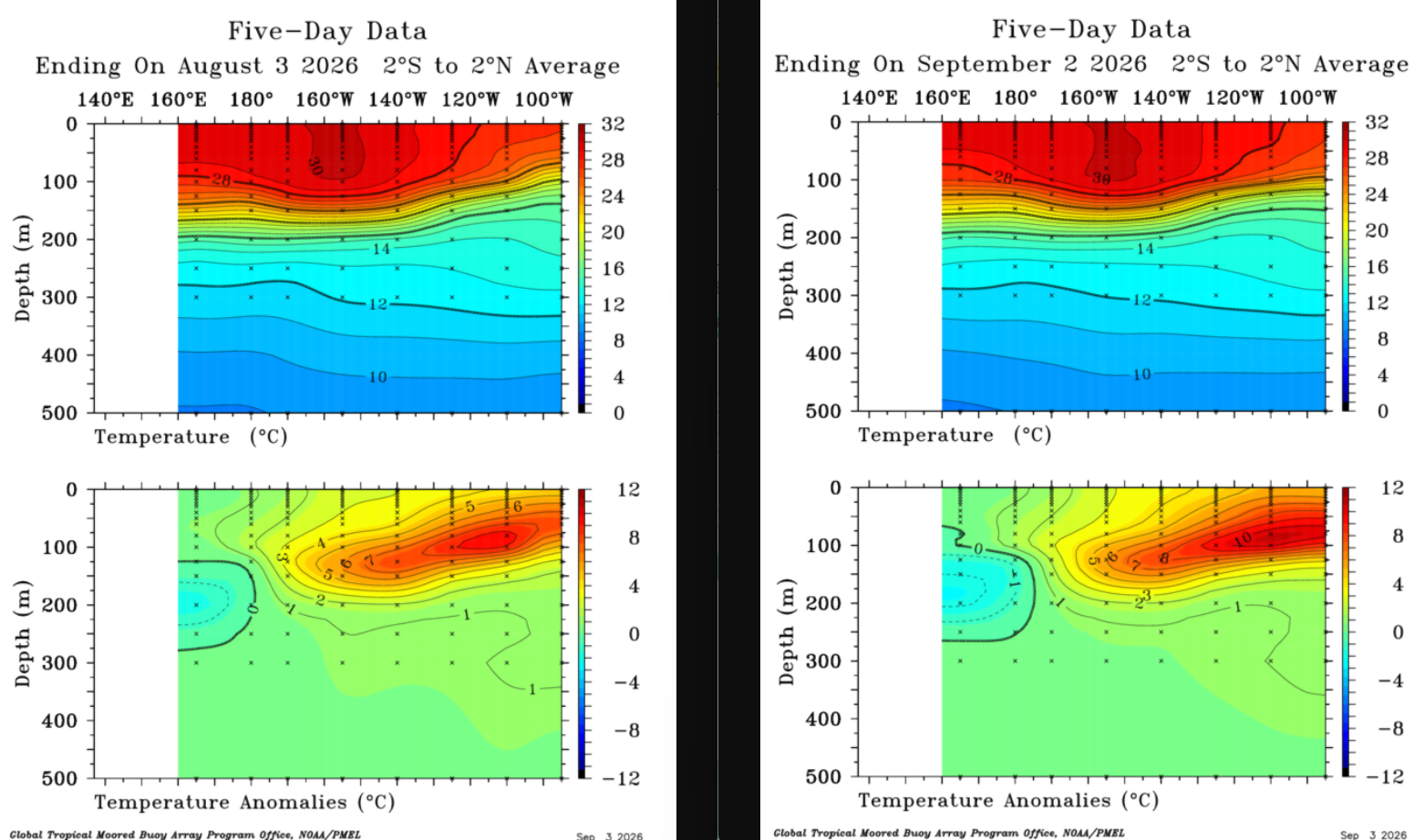
2026-2027 Record-breaking El Nino
GaWx replied to Stormchaserchuck1's topic in Weather Forecasting and Discussion
Indeed, it has become more E based despite a flat Nino 3.4 recently since Nino 3 has warmed some while Nino 4 has cooled some netting out to an essentially flat period for Nino 3.4. -
I'll tell you though, it felt great running in 69 degrees and cloudy yesterday. Not nice weather obviously, but great for outdoor exercise.
-
Thanks, Charlie. Interesting. The contradiction of viewpoints/supporting data and info as well as the complexities involved in this terrible disaster are why I said that most of what Martz put in that post is at least worthy of discussion/debate. I think that the odds of CC being at least a little involved are high. I feel that the main debate is whether CC was a major factor or just a minor factor. I agree that it’s too early to conclude anything and there likely will be continued disagreements in upcoming releases. We may never know the exact answer.
-
Taking my car tot he car wash, so we will get hit hard with storms later.
-
Excellent afternoon AFD from LWX for tonight into tomorrow .DISCUSSION... KEY MESSAGE 1...Slight Risk of severe thunderstorms today and Friday. Clouds have readily thinned in the wake of morning shower and thunderstorm activity. This is allowing for temperatures to rise quickly through the 80s to near 90. This heating will play an important role in the potential for severe weather through the evening hours. As of 2:30 PM, a few discrete (transient supercell) thunderstorms had developed over the Shenandoah Valley, and had a history of producing large hail and wind damage. These storms are developing in an area that has been clear since daybreak, and in an area of enhanced low-level convergence due to residual outflow from morning convection to the north, a washed out front, and terrain circulations. Anticipate this activity to continue into the late afternoon hours with a risk of localized damaging wind gusts and large hail. Meanwhile, upstream over the lower Great Lakes and Ohio Valley, a large reservoir of MLCAPE 3000-4000+ J/kg exists. The north end of this CAPE pool lies along the southern edge of the westerlies, with a 100+ kt 300 hPa jet streak and mid-level shortwave impulse located just to the north. This setup is favorable for the development of a Mesoscale Convective Complex (MCS), which is an organized line of thunderstorms that persists for several hours. Locally, mid-level lapse rates of 6.5-7 C/km (per latest mesoanalysis and the KIAD 12Z RAOB) atop a very moist boundary layer with surface dew points well into the 70s F will lead to increasing CAPE despite the late start at surface heating. The question then becomes just how organized upstream storms become, and how stable the boundary layer is heading further into the evening. A more organized and potent line of storms a bit earlier in the evening would result in a notably higher risk for more numerous damaging wind gusts, especially focused along the residual baroclinic zone/theta-e gradient which should lie near the Potomac River/US-50/I-66 this evening. A somewhat slower and/or more disorganized line would result in a lower risk for severe surface gusts, though some isolated damaging winds would still be possible given high CAPE/DCAPE and the shallow nature of the stable layer near the surface. Areas of western Maryland and perhaps into the eastern West Virginia panhandle are most likely to see the storms prior to the onset of appreciable nocturnal boundary layer stability. The area remains in a Slight Risk (level 2 out of 5) for severe weather from SPC as of the midday outlook update, driven mostly by the threat of damaging wind gusts. There is a threat for large hail in stronger cores, though mid-level lapse rates will gradually become less steep tonight. A linear storm mode would tend to be less favorable for large hail production (as opposed to discrete/individual cells), as well. A few discrete cells are possible this evening in weak low-level WAA, however, independent of any linear system that may affect the region. These storms would be most likely to develop over northern and central Virginia into central Maryland along a weak surface trough and the aforementioned moisture/instability gradient. Additional showers and thunderstorms, possibly strong to severe, are anticipated again on Friday. Timing is a bit uncertain given the subtle waves aloft, but increasing low-level convergence paired with another upper impulse may very well result in another round or two of storms with a damaging wind risk. The latest guidance has nudged the threat a bit further north, encompassing areas as far north as I-70 or the Mason-Dixon line (as opposed to I-66/US-50). This will depend on any residual early day clouds or convection, of course.
-
Just went out to my truck to get something and its just 101.1 outside here. Did you get any rainfall from the cell yesterday late in the day? Its been bone dry here for the last week and a half.
-
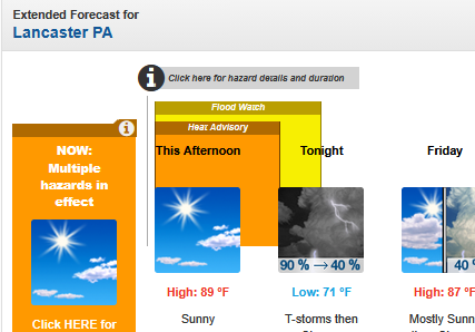
I see Mt. Holly and State College both issuing Heat Advisories for temps in the 80s now. (Maybe residual from a blown forecast or something. But still...)
-

Septorcher 2026 Discussion - Endless Summer
weatherwiz replied to Damage In Tolland's topic in New England
probably just misses east but given the strength, way too close to totally write off now for some of those islands. Big Island probably fine outside of dangerous waves but those far northwestern islands...I'd be a little sweaty if I were them. -
Ring of Fire week of mid 90s in September produces not a single drop of rain here. Not one.
-

2026-2027 Record-breaking El Nino
LakePaste25 replied to Stormchaserchuck1's topic in Weather Forecasting and Discussion
As I said yesterday, despite the “pause” in Nino 3.4 in August, it has become significantly more east-based regardless.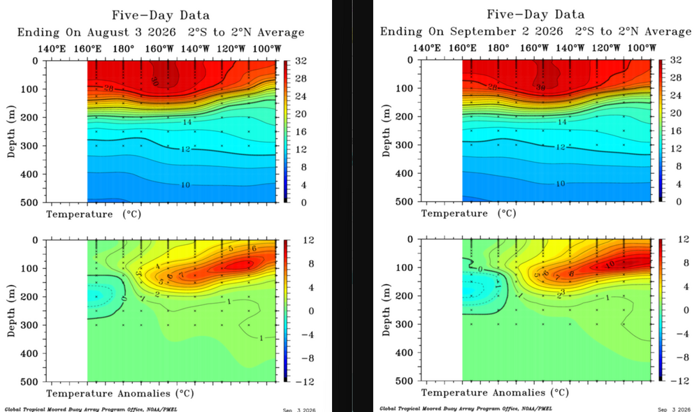
-

Septorcher 2026 Discussion - Endless Summer
WxWatcher007 replied to Damage In Tolland's topic in New England
Looks like a very near miss to me. I had flights and hotels pulled up yesterday though. -
Such a storm today would be unreal with regard to damage
-
 Similarities to 2025. That's what I thought you meant when responding to my post. Edit: nevermind, I see the PNA was negative 3/4 months last year. We are also following 2024 close with the 90N Summer +AO and that had this DJF PNA 1.70 2025 1.05 1.41 80-90N ridging in the Winter sometimes will pop a low south of it, over the Aleutian islands. That's what I mean by +PNA coming from the arctic
 -
That's what the model predicted. I'm not talking about the Great Lakes.
-
2026-2027 Record-breaking El Nino
GaWx replied to Stormchaserchuck1's topic in Weather Forecasting and Discussion
Nino 1+2 is very warm, but Adam’s post: -is ignoring the effect of GW on skewing Nino 1+2 upward in 2026 vs 1997. The highest relative weekly in 1997 was +4.1 (set twice). Relative values for Nino 1+2 are currently 0.5 or more cooler than the non-relatives. NOAA and other orgs have recently been using relative values as official because of the skewing caused by GW. -He’s looking at yesterday’s daily rather than at a weekly average, which is what the historical data is based on. -These OISST charts have recently been warmer than the released NOAA weeklies as has been noted in many posts since July. -Let’s see what this Monday shows for relative Nino 1+2 averaged over this week. I doubt it will reach +4.1, but we’ll see. I’m guessing high 3s. -

2026 Mid-Atlantic Severe Storm General Discussion
Eskimo Joe replied to Kmlwx's topic in Mid Atlantic
It's likely the hail core interfering with the radar beam. Note how the broad rotation is behind the best VIL.- 2,408 replies
-
- 1
-

-
- severe
- thunderstorms
- (and 7 more)
-
There were 2 tornadoes within the derecho
-
I thought that was a tornado outbreak. That's how my mind remembers that event anyway. Didn't we have another one around Memorial Day weekend in the same year?
-
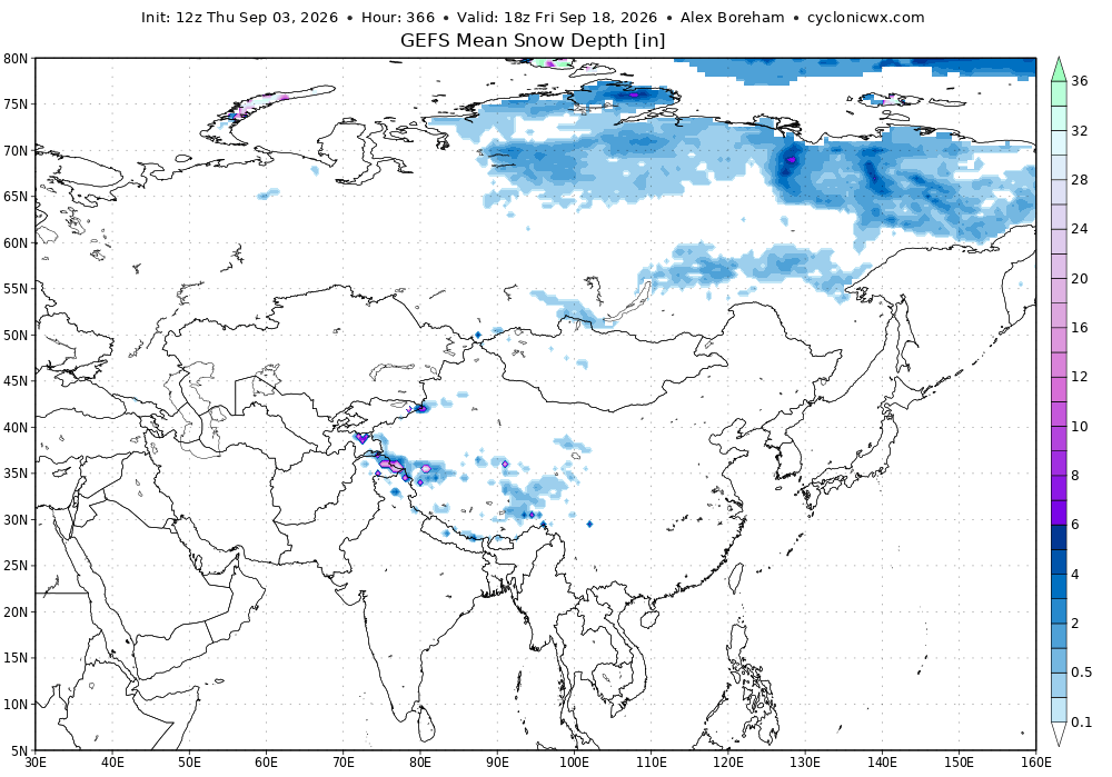
almost that time of year. GEFS is hinting at a pattern favorable for early season snow cover advance, but time will tell on that.
-
The HRRR shows nothing for Augusta/Rockingham thru 4 pm. It is wrong as convection is firing Staunton to Harrisonburg. The NAM 3k is on the money. Sorry to lose it.
-
By all accounts the 1821 hurricane that hit NYC on this date was even worse. A Cat 4 right into NJ and a Cat 3 up to NYC and a direct hit! Our own Labor Day hurricane before Labor Day even existed!