All Activity
- Past hour
-
Could be a dirty filter, or having the temp control(thermostat) set to run the fan all the time(On) instead of setting it to Auto.
-
I had to zoom in pretty far to make out the new icon image. At first I thought it was crab.
-
 It’s real https://www.fox8live.com/2026/06/27/heat-humidity-this-weekend-storms-return-mid-week/
 -
With some of the hardcore warminstas in there, yeah anything positive posted (cold/snow) about the upcoming winter will probably earn you a weenie.
-

Central PA Summer 2026 Discussion/Obs Thread
pawatch replied to Voyager's topic in Upstate New York/Pennsylvania
85 degrees DP 69 I’M sweating…wheel barrowing topsoil 700 cubic feet. -

2026 Mid-Atlantic Severe Storm General Discussion
high risk replied to Kmlwx's topic in Mid Atlantic
I think it's justified. Lapse rates and instability are modest, but shear is workable, and convection should be organized and timed well for our area. CAMs all look pretty good. Friday has some potential too.- 983 replies
-
- 1
-

-
- severe
- thunderstorms
- (and 7 more)
-
The 12z GFS was very robust to our north with the EML plume middle of next week. It's focused up into PA but it's been jumping around a lot and varying in intensity the past handful of runs. This is the most impressive I've seen it depicted to this point. Large area of 8+ values up in PA. It then gets shunted off the coast without really getting across the M/D line (actually kind of comical how it kind of just stops at the border). This will be the thing to watch for severe chances next week.
- 983 replies
-
- 2
-
-
- severe
- thunderstorms
- (and 7 more)
-

Winter 2026-2027 Seasonal Outlook
GaWx replied to WinstonSalemArlington's topic in Southeastern States
I just posted this elsewhere: 1. Asheville temp. records go back to 1876 and thus include 1877-8. Whereas Dec was mild/AN at 43.6, Jan was actually snowy and cold/BN (35.2) and Feb was NN (39.8). So, DJF averaged 39.5, which is actually NN. In Jan, they had well above normal snow with 4” on the 4th and 4.5” on the 31st! They had a low of 7F on the 7th. So, I wonder why this source per your post said:The winter of 1877–1878 in North Carolina was remarkably warm, largely recognized as an exceptionally mild season brought on by a historic 'Super' El Niño event.This doesn’t at all jibe with this Asheville data and I haven’t found any data for any other locale in NC going that far back.Data from here: https://www.weather.gov/wrh/Climate?wfo=gsp —————2. Regarding other super-El Nino winters in the SE:-1888-8: Feb 1889 had a SE major snowstorm and was cold allowing for DJF to avg BN-1957-8: cold winter overall with cold in Jan and especially Feb. and was snowy overall, esp in Feb, which included deep SE-1965-6: cold winter overall thanks to quite cold in Jan and overall snowy in part of SE thanks to Jan/Feb-1972-3: historic ZR Jan N GA and vicinity; historic snowstorm Feb AL to NC, including deep SE; overall NN temps with BN Feb-1982-3: very snowy much of SE, including historic snow much of area in spring! ATL had biggest snowstorm as well as snowiest winter since 1939-40! It hasn’t been matched since! Overall NN temps.-1991-2: ATL and nearby had a major snowstorm in Jan. Otherwise it was a mild winter.-1997-8: NN temps overall with cold Dec, mild Jan, and NN Feb-2015-6: AN temps overall due to warmest on record Dec as JF were actually BN to NN—————In summary, -a super-Nino doesn’t point to an expected warm SE winter as only 2 of the 9 averaged mild in DJF. Only one, 1991-2, averaged mild throughout DJF.-Super El Niño winters tend to average mild in the N tier of the US, not the SE.-Dec will be favored to be AN as 6 of these 9 had a mild Dec, including the warmest on record-Jan/Feb averaged out will be favored to be BN with most of the 9 BN overall, with some quite cold months in some cases-AN wintry precip prospects are better than avg. All it takes is one major snow in the SE in many cases.-AN rainfall prospect is the best news of all due to the drought! -
Hoisting the Sultan Signal: Heavy Rain Event July 5-7
dendrite replied to WxWatcher007's topic in New England
Bummer. Not even a dent. -
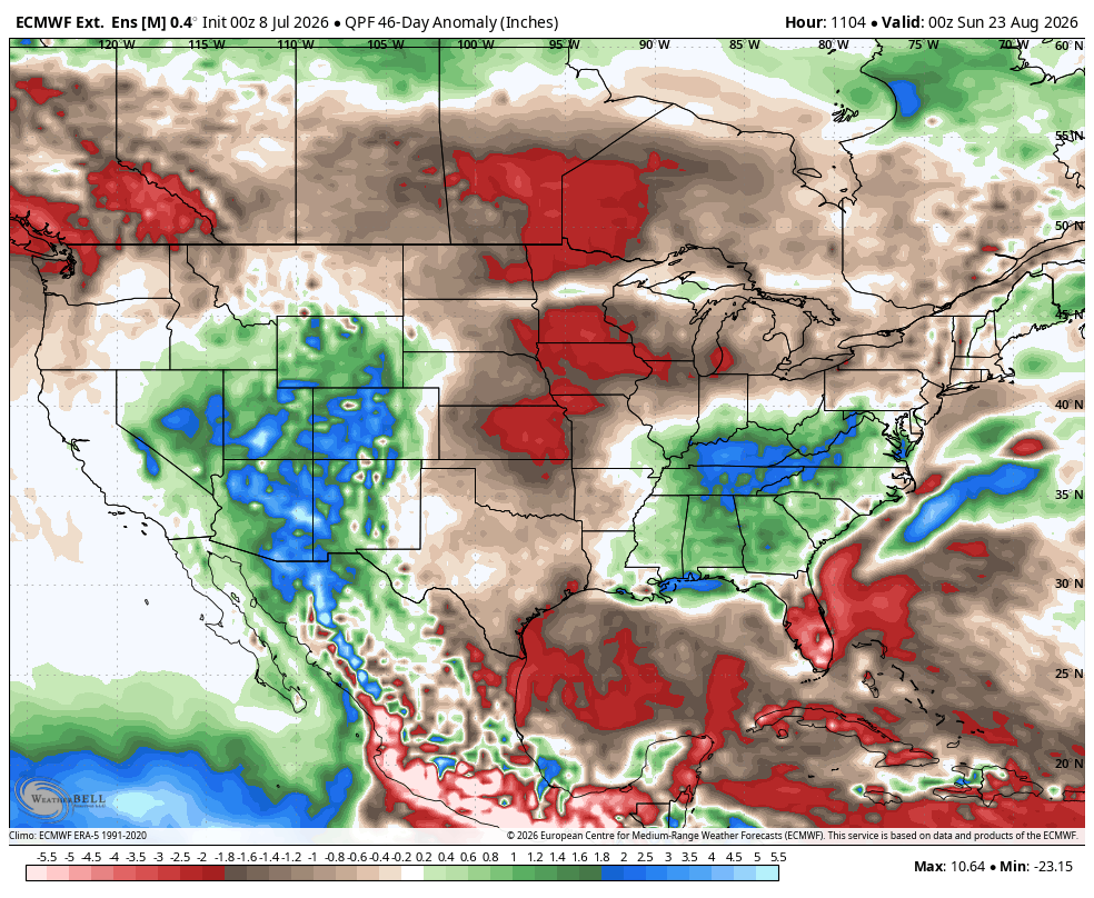
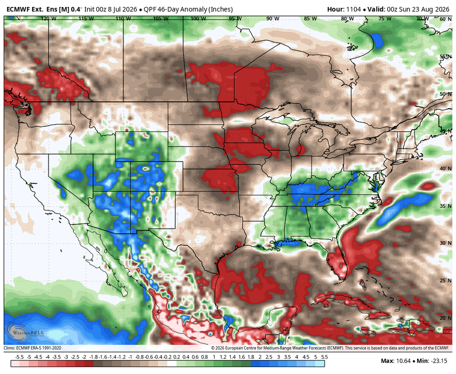
The long range extended EPS really wants to dry out the Plains. This is a signal for the shorter term guidance to keep correcting stronger with the 500mb ridges and heat than what the longer range guidance has been showing. So it’s possible our area could continue to see repeating major heatwaves from time to time through at least the rest of July.
-

2026-2027 Super El Nino
Stormchaserchuck1 replied to Stormchaserchuck1's topic in Weather Forecasting and Discussion
That kind of SSTA orientation in the N. Atlantic right now favors a -NAO Winter. -
88...above forecast
-
 I don’t think most people realize how dangerous this is at a societal level.
 -
Might be able to sneak in a 90 today, gonna be super close… With dew-points in the 60s though it doesn’t feel too bad at all in the shade. Perfect summer day! That hot and muggy stretch last week really did a wonderful job of acclimatizing my body for deep summer heat. After a week full of mid-upper 70s DPs under my belt, my tolerance for upcoming heat has certainly gone up. Today was easy peazy.
-

Occasional Thoughts on Climate Change
Typhoon Tip replied to donsutherland1's topic in Climate Change
Synoptic scaffolding of what's going on between the Azores and the Urals through that area of the hemisphere really argues for the apex of this current burst to be about 4 days from now. - Today
-
Yes, but may have something to do with me turning the AC off and opening the windows. That said, I noticed it before turning it off. Imagine has something to do with the indoor and outdoor temperature (at least in my house) being equal, thus the AC not running as often and therefore not dehumidifying at the same level?
-

Central PA Summer 2026 Discussion/Obs Thread
Voyager replied to Voyager's topic in Upstate New York/Pennsylvania
Well, hopefully those who saw them this past weekend won't see them again. -
 ....I can't even begin to tell you how bad it is with hs students including athletes. We literally have to teach players how to pay attention and how to absorb and understand what is being taught.
 -
It’s not nearly as hot as last week but I still suffered in the humidity while working in the yard. I’m getting soft in my old age.
-
Hopefully the outflow boundary delivers as it moves through Raleigh.
-
 I visualize data for a living. I can't imagine there being a circumstance where I would find that graphic meaningful. It would even be odd if your range was 90-95. The word "authority" is doing a lot of heavy lifting IMO.
 -
what about the heavy T- storms tomorrow and Friday with possible flooding downpours ?
-
Falls lake getting hit yet again. Just a storm magnet all of a sudden.
-
Upgrade to slight for tomorrow for DC and points east?
-

Occasional Thoughts on Climate Change
donsutherland1 replied to donsutherland1's topic in Climate Change
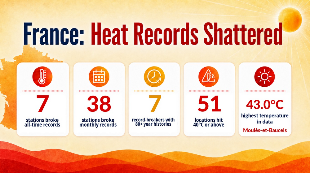
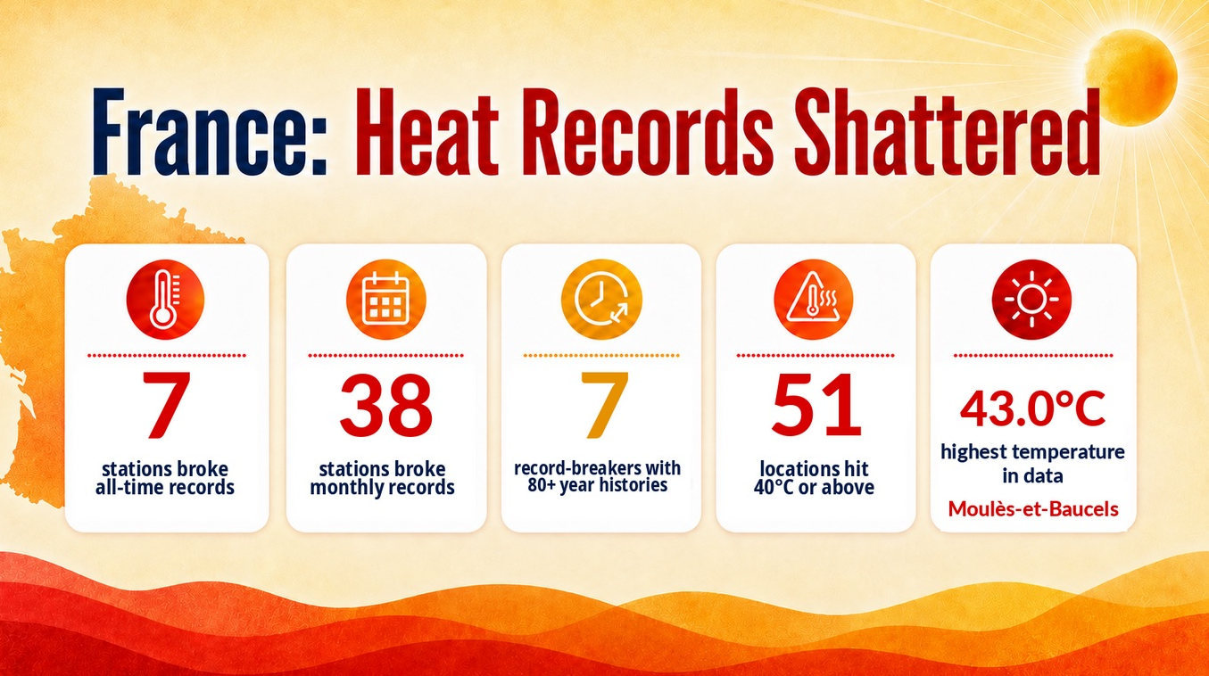
All-time record heat returned to France today. The temperature reached as high as 109.4F (43.0C) today.