All Activity
- Past hour
-

January 25-26 Winter Storm Potential
Hurricane Agnes replied to Ralph Wiggum's topic in Philadelphia Region
Not so much for ice (sleet/ZR) versus snow though.... Although I remember going on a senior class trip to Tamiment in the Poconos back in '79 in January and there was ZR that weekend with the slopes too slick to ski on and then the temps hit 40, so it was either ice skating in their indoor rink or board games. -
It was always a B/C to me Though technically for us it's an over running warm front style thump as the coastal does nothing here and hits New England
-
Ah...don't know why I though tthat was "much" later
-

Jan 24-26 Weekend Snow and Sleetfest Model Thread Part Tres
Solution Man replied to H2O's topic in Mid Atlantic
The cleaner transfer to the coast is cleaner and earlier -
 NWS has 7-11 Sunday and 2-4 Sunday night at Farmingdale
 -

Pittsburgh/Western PA WINTER ‘25/‘26
southpark replied to Burghblizz's topic in Upstate New York/Pennsylvania
Me too -

Pittsburgh/Western PA WINTER ‘25/‘26
SteelCity87 replied to Burghblizz's topic in Upstate New York/Pennsylvania
My point and click just jumped to 5-9 on sunday fwiw. -
Bigger as in a larger geographic spread? Doesn't really make a difference since Jan 22 hit Boston hard. Given the cold, it will be a good stress test for the T.
-

Fall/Winter Banter - Football, Basketball, Snowball?
tnweathernut replied to John1122's topic in Tennessee Valley
If I ever move from the house my wife and I built, just know it will be somewhere north and west of I-81.............. Not sure why i need to tell you guys this, but felt it needed to be verbalized. lol -

January 24-26: Miracle or Mirage JV/Banter Thread!
Nomz replied to SnowenOutThere's topic in Mid Atlantic
when green line go past blue line bad -
January 24-26: Miracle or Mirage JV/Banter Thread!
32º replied to SnowenOutThere's topic in Mid Atlantic
I assume that freezing rain could cement all the sleet into one solid mass. -
 this i think 8-10 a great forecast for a wide swath south of 78, if you want to account for under or over performance a general 6-12 from north central jersey through middlesex ocean monmouth down to philly
 -

Central PA Winter 25/26 Discussion and Obs
GrandmasterB replied to MAG5035's topic in Upstate New York/Pennsylvania
If you toggle 0Z and 12Z it's definitely a small improvement at 12Z for us southerners. Central is a solid hold, maybe a hair drier but really just noise. This 12Z run falls in with other guidance either holding that sleet line off or giving us an extra 30 miles or so of breathing room. -
.thumb.jpg.6a4895b2a43f87359e4e7d04a6fa0d14.jpg)
Central PA Winter 25/26 Discussion and Obs
Yardstickgozinya replied to MAG5035's topic in Upstate New York/Pennsylvania
-
 Rambler I cannot post this image gif. If you’d be kind to do so. Definitely can see how things are unfolding with it. .
 -

Pittsburgh/Western PA WINTER ‘25/‘26
colonel717 replied to Burghblizz's topic in Upstate New York/Pennsylvania
Look to mesos to pick out the banding. -
.thumb.jpeg.f5c6ba9d911ec96b3b124f8606aee58e.jpeg)
Possible Record Breaking Cold + Snow Sunday 1/25 - Tuesday 1/27
TJW014 replied to TriPol's topic in New York City Metro
Updated map. Will this pan out? No clue, but that's why I'm not a met. Some minor tweaks from the last one, and unless we see major trends within the next 24 hours, I don't think I'll make any adjustments. I guess you could call it a near worse-case scenario but I'm sticking to a lower/conservative side. I think the mixing line makes it up to CT, then following just north/west of the Fall Line. ENE winds will bring a period of rain to coastal NJ, keeping totals lower. Freezing rain up to 0.25" possible for inland NJ, south of Raritan Bay. However, if the mixing line quickly retreats, or doesn't even make it that far north/east, totals here will be higher, possibly add 50% to what's projected on the map (not in pink). Areas north/west of Easton, PA - Mahwah, NJ should remain all snow, 12-18" likely, possibly higher amounts in higher elevations.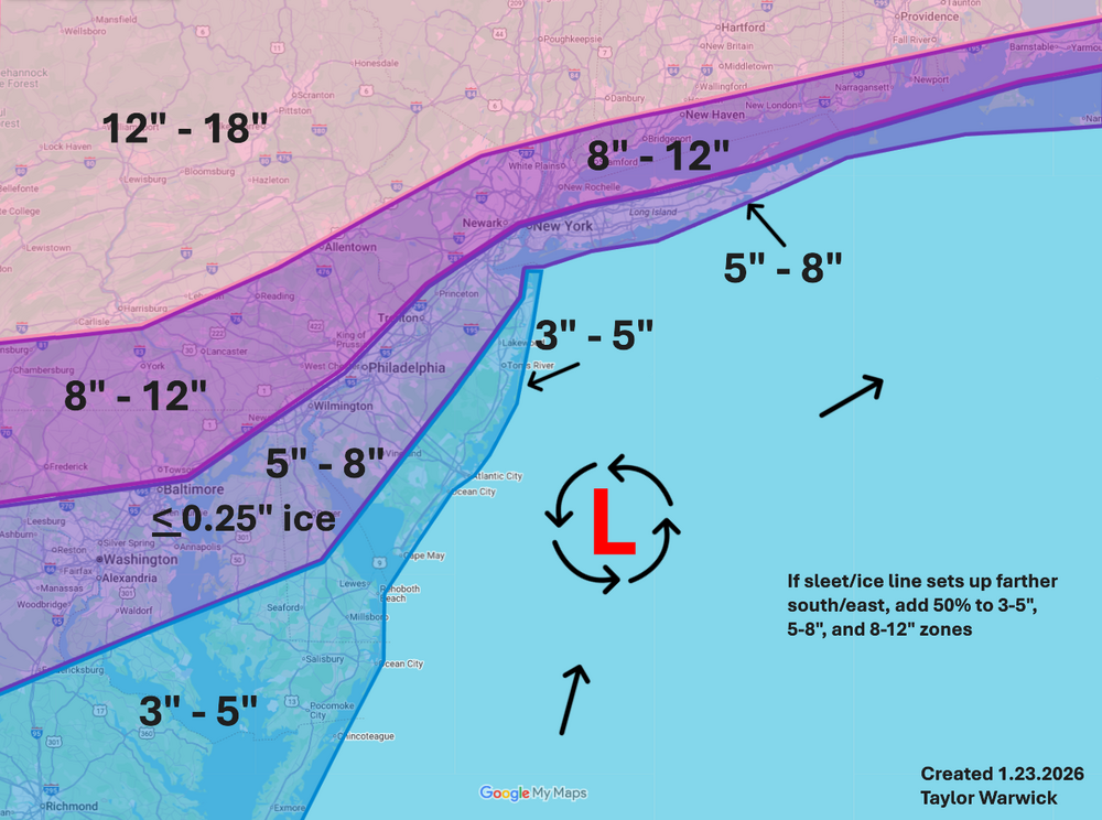
-

Pittsburgh/Western PA WINTER ‘25/‘26
MikeB_01 replied to Burghblizz's topic in Upstate New York/Pennsylvania
Classic . -

January 24-26: Miracle or Mirage JV/Banter Thread!
caviman2201 replied to SnowenOutThere's topic in Mid Atlantic
Ok that really is impressive now that Mt. Holly has issued their warnings... -
Fall/Winter Banter - Football, Basketball, Snowball?
tnweathernut replied to John1122's topic in Tennessee Valley
I can see the future with Musk in charge of a weather model..................... Looks like a snowstorm 17 days from now (8-12 inches). Thanks, I'll head to the store and buy a shovel. -
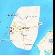
RAH Issues Winter Storm Warning for rest of central NC ...WINTER STORM WARNING IN EFFECT FROM 7 PM SATURDAY TO 1 PM EST MONDAY... * WHAT...Heavy mixed precipitation of largely sleet and freezing rain expected. Total ice accumulations between three tenths and three quarters of an inch. Total sleet and snow accumulations up to two inches. * WHERE...For much of the Piedmont and northern Coastal Plain of central North Carolina. * WHEN...From 7 PM Saturday to 1 PM EST Monday. * IMPACTS...Significant ice accumulation on power lines and tree limbs may cause widespread and long-lasting power outages. Travel could be treacherous. The hazardous conditions could impact the Monday morning commute. PRECAUTIONARY/PREPAREDNESS ACTIONS... Persons should consider delaying all travel. If travel is absolutely necessary, drive with extreme caution. Consider taking a winter storm kit along with you, including such items as tire chains, booster cables, flashlight, shovel, blankets and extra clothing. Also take water, a first aid kit, and anything else that would help you survive in case you become stranded.
-

Jan 24-26 Weekend Snow and Sleetfest Model Thread Part Tres
baltosquid replied to H2O's topic in Mid Atlantic
I can't speak to how good it is, but now that you mention the RRFS, heights got lower a tick at the end of its 15z run. Only out to 18 hours but at that point precip is already starting in the south central CONUS. This isn't a high value data point or anything but better than the other direction. -

January 2026 Medium/Long Range Discussion
NorthArlington101 replied to snowfan's topic in Mid Atlantic
It's got it, just buries it into the Gulf of Mexico and struggles to get it up the coast once it crosses over Florida. Goes OTS -

Jan 24-26 Weekend Snow and Sleetfest Model Thread Part Tres
IUsedToHateCold replied to H2O's topic in Mid Atlantic
Glad to see the southward trend continues. Nina FTW. NAM thermals from this morning are probably overbaked, we will get a better grasp tomorrow on p-type. I feel confident that even if we sleet a lot, the sleet is going to really pile up, but I'm more confident we're going to see a lot of snow. I'm sticking with 10-12 for DC. -

1/24-1/25 Major Winter Storm - S. IL, IN, and OH
michsnowfreak replied to A-L-E-K's topic in Lakes/Ohio Valley
Hopefully the bleeding has stopped. Still a difference between American and foreign models. Temps will be in the low teens during the snowfall 12z qpf for DTW ICON- 0.15 GFS- 0.18 NAM- 0.24 GEM- 0.31 EUR- 0.31 RGEM- 0.36