All Activity
- Past hour
-
This pattern has been absolute hell. Not only did last weeks pressure changes mess with migraines and sinus issues, but I am in the process of moving and trying to conserve air conditioning and the temperature has either been too hot or when it does cool down, the air is some of the most wet and soupy mix I have ever felt.
-
not only severe, but WPC says flooding could be a concern too: Mesoscale Precipitation Discussion: #0227 (Issued at 635 PM EDT Mon May 05 2025 ) MPD Selection Mesoscale Precipitation Discussion 0227 NWS Weather Prediction Center College Park MD 635 PM EDT Mon May 05 2025 Areas affected...portions of eastern VA into the DMV and far eastern WV Concerning...Heavy rainfall...Flash flooding possible Valid 052235Z - 060300Z Summary...Training convection will be capable of hourly totals of 1-3" with short-term (3-hr) totals as high as 2-4". Isolated to scattered instances of flash flooding are possible (and may be locally significant in sensitive urban/mountainous terrain). Discussion...Radar and GOES-East satellite imagery indicate the proliferation of convection across portions of eastern VA/NC over the past several hours, moving fairly rapidly (~25 kts) towards the N-NE within nearly unidirectional flow on the eastern periphery of a large, deep layer (850-200 mb) closed low centered over IL/IN/KY. The mesoscale environment in the vicinity and downstream of the aforementioned convection is characterized by SBCAPE of 1000-2000 J/kg, PWATs of 0.8-1.3" (between the 75th and 90th percentile, per IAD sounding climatology), and deep layer (0-6km shear) of 20-40 kts (per 22z SPC SFCOA analysis). The strongest cells have been capable of impressive instantaneous rainfall rates of 3-5"/hr (per MRMS estimates), which has resulted in estimated hourly rainfall totals of up to 2.5" (where deeper convective cells have been able to occasionally train, mainly to the east of I-95 in eastern VA). Recent hi-res CAMs have not handled the evolution of convection particularly well, and recent observational trends (including continued overshooting/cooling cloud tops via GOES-East imagery) suggest that localized hourly totals of 1-3" will continue to manifest farther north (into the more sensitive DMV region) with storm propagation (as a pool of 1500-2000 J/kg of SBCAPE remains untapped). While both of the hourly updating CAMs (HRRR/RRFS) are handling the convection poorly, the 18z HREF suite does still give a good idea of the potential for excessive rainfall through 03z (with 40-km neighborhood probabilities for 2" and 3" exceedance of 20-30% and ~10%, respectively). Given locally sensitive terrain (per FFGs as low as 0.75-1.50" and 1.50-2.50" for 1-hr and 3-hr periods, respectively) over urbanized terrain along and near I-95 and over portions of the Appalachians in the vicinity of northern VA, western MD, and far eastern WV, isolated to scattered instances of flash flooding are possible (and may be locally significant, should 2-4" totals occur over the most sensitive localities). Churchill ATTN...WFO...AKQ...CTP...LWX...RAH... ATTN...RFC...MARFC...SERFC...NWC... LAT...LON 39827743 39597667 39037647 37767669 36447699 36217739 36777738 37437742 38277778 39617833
-
Even 1:1 ratios would be great
-
that's the only model that looks like that and the radar does not look like that will verify.. congrats on hitting the wrong nail
-
I'm at .06 today .21" total. I didn't want the 5" that the euro had, but was looking for 1.5" or so. We will see what happens the next day or so I guess.
-
Beautiful afternoon
-
Luckily, the shed structurally came through pretty well. Just need to add a some roofing once I figure out how to remove our fallen friend.
-
After awhile of living down here in the desertification district of Texas, you catch on. Reportedly decillions of long metric tons of rain are on their way today, tonight and early tomorrow. I believe it. But those green flood watches. They are 170 miles NORTH of us. You live down here long enough, you learn. We are shyte out of luck - AGAIN. We'll see drizzle, and hours and hours and hours and hours and hours and hours and hours and hours and hours and hours and hours and hours and hours and hours and hours and hours and hours and hours and hours and hours and hours and hours and hours and hours and hours and hours and hours and hours and hours and hours of light mist and light drizzle. The 9 billion year rains are bubbling up all around Buda, but rest assured 99.9999999999999999 percent of the rain will - you guessed it - waterboard Dallas and points north and east. This includes Washington DC. Some communities in Dallas have already gotten 23 plus this year and are on track for a 60 inch rain year easy. NOT US. NO WAY. Not even in 1 million years. Not even one season like that. Rain hates me and rain absolutely abhors Buda. Some horrible pos has erected a permanent Klingon Anti Rain Shield around north Hays County. We are shyte out of luck. We'll have category 987 -level Drought by September, and cracks in that ground so wide, I will fall in AGAIN and really shatter my left knee this time! The Austin Metropolitan Region is out of luck for the foreseeable future, probably well into the 2030s. We are so up shyts creek, that Texas could get a Cat 5 hurricane. We'd get the 190 mph winds, the tornadoes and the damage. We'd get probably half an inch of rain, while Dallas would get about 14 feet of rain and the Trinity River would get so high it would drown south Oklahoma. I would sell everyone out, for a chance to live in Cherrapunji, India. They get ~1050 inches a year, every year.
-
Biggest heat this summer will mostly be well west of New England.
-
That is a wild severe warning box
-
That cell turned out to be wicked, turned into Quarter size hail. Lots of leaves down and a gust to 47 mph. Luckily it has moved North now and seems as if the vehicles didn’t get any damage.
-
Tornado warning just NE of Richmond.
-
Looks like another sneaky severe evening.
-
Congrats Freak and Dendy and Dryslot
-
Plenty of time to trend north which seems likely
-
Perfect track Fri/Sat for SNE. I don’t want to hear any bitching come winter now.
-
Had a decent downpour that got us to 0.15" for the day here. 0.55" for the event so far, which is pretty disappointing. Hopefully we'll get lucky with a t-storm tomorrow afternoon. If not, the advertised big soaking 4 day period is going end up a big disappointment. Definitely a big bust for the Euro model which showed ridiculously high amounts for days.
-
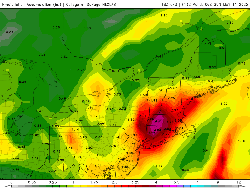
.71 so far. Radar looks anemic for now We’ll see how the 3-6” forecasts here some had and flood watches work out . Time will tell
-
1.2” today, 3” MTD
-
Just got warned BULLETIN - IMMEDIATE BROADCAST REQUESTED Severe Thunderstorm Warning National Weather Service Baltimore MD/Washington DC 617 PM EDT Mon May 5 2025 The National Weather Service in Sterling Virginia has issued a * Severe Thunderstorm Warning for... Northwestern Stafford County in northern Virginia... Southeastern Fauquier County in northern Virginia... Southern Prince William County in northern Virginia... * Until 645 PM EDT. * At 616 PM EDT, a severe thunderstorm was located 7 miles west of Stafford, moving north at 15 mph. HAZARD...Quarter size hail. SOURCE...A trained weather spotter observed quarter size hail in Glendie. IMPACT...Some hail damage to agriculture is expected. * Locations impacted include... Heflin, Ruby, Somerville, and Roseville. PRECAUTIONARY/PREPAREDNESS ACTIONS... For your protection move to an interior room on the lowest floor of a building. && LAT...LON 3841 7748 3840 7756 3854 7767 3858 7751 TIME...MOT...LOC 2216Z 158DEG 15KT 3842 7754 HAIL THREAT...OBSERVED MAX HAIL SIZE...1.00 IN WIND THREAT...RADAR INDICATED MAX WIND GUST...<50 MPH
- 477 replies
-
- 1
-

-
- severe
- thunderstorms
- (and 2 more)
-
I picked up a bunch of veggie plants today and was going to put them in this evening, but I’ll wait a day and keep them safe under the patio table. In other words, I’m jinxing myself out of any thunderstorms tonight.
-
Looking at RadarScope again I think it’ll scoot to my west, but I’ve heard rumbles in the distance, so who knows.
-
CT should be ok by Sat late morning but AEMATT may have a wettie
-
Storm total here now .92
-

2025 Lawns & Gardens Thread. Making Lawns Great Again
Brewbeer replied to Damage In Tolland's topic in New England
mine's getting long and it's only Cinco de Mayo !


.thumb.png.4150b06c63a21f61052e47a612bf1818.png)


