All Activity
- Past hour
-
We'll see what August has to offer but you have to think the hottest of the hot is behind us for this summer. With the wet period underway that would tend to make it harder to reach into the upper 90's +.
-
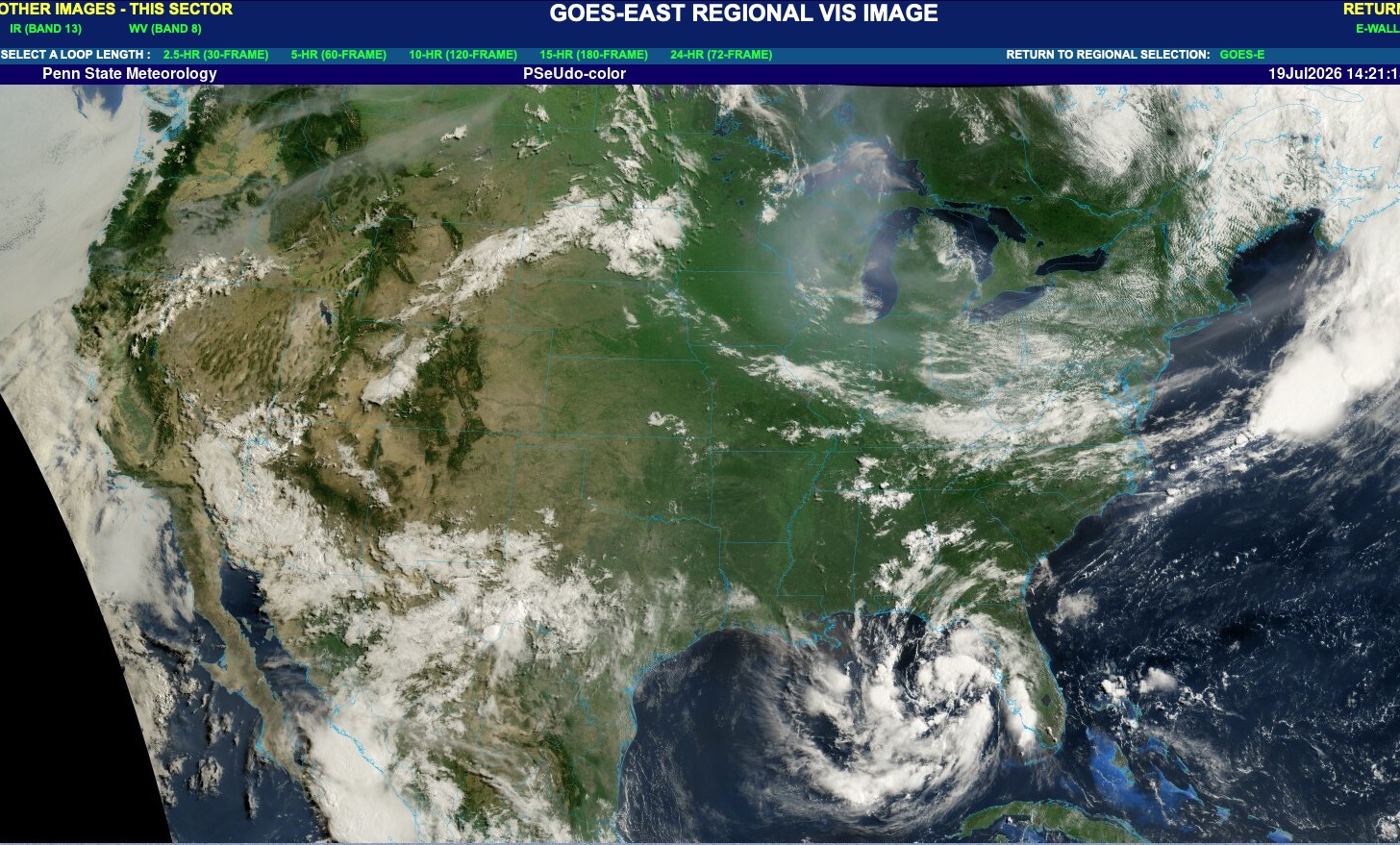
Why does it seem like there’s still residual wildfire smoke?
-
Happy to have joined the smoke party that we missed out on last week.
-
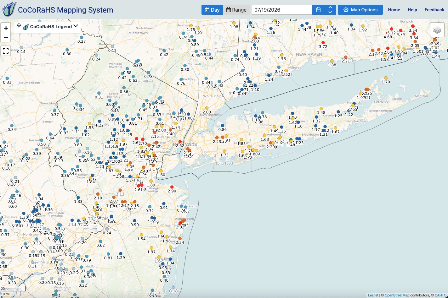
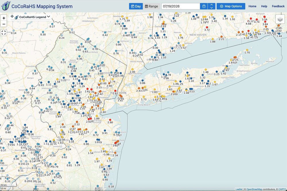
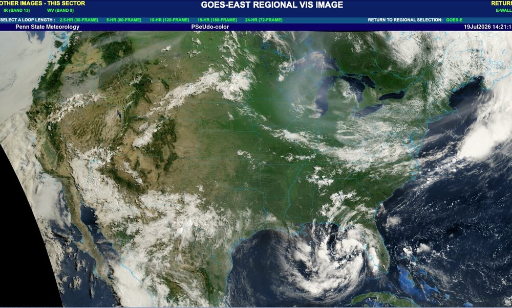
Total rainfall here yesterday was.99". Received .92" from morning round and just .07" second round during the evening. Nice out this morning with a light breeze, generally blue skies although some slight haze is lingering. Smoke still continues to spill into the western lakes region and then filters east from there. Much more diluted than recent days. Rainfall map attached. Western areas of the sub forum kind of got shafted. Surprised some locations didn't see bigger totals based on training echoes on radar yesterday south of 78 and north of I195 and across the city and LI. My lawn is looking great for mid July! I have not had to water much if at all over the last month around here. Enjoy the day!
-
TD2 advisories to be initiated at 11AM.
-
It seems that I got lucky yesterday compared to nearly CoCoRaHS stations, and ended up with .77” from early and afternoon storms. The two closest stations to my east got about half that. I also didn’t expect to still smell smoke today.
-
Corrected July 18. Had July 19 in there. When I was doing July 19, I was like "That looks familiar" lol.
-
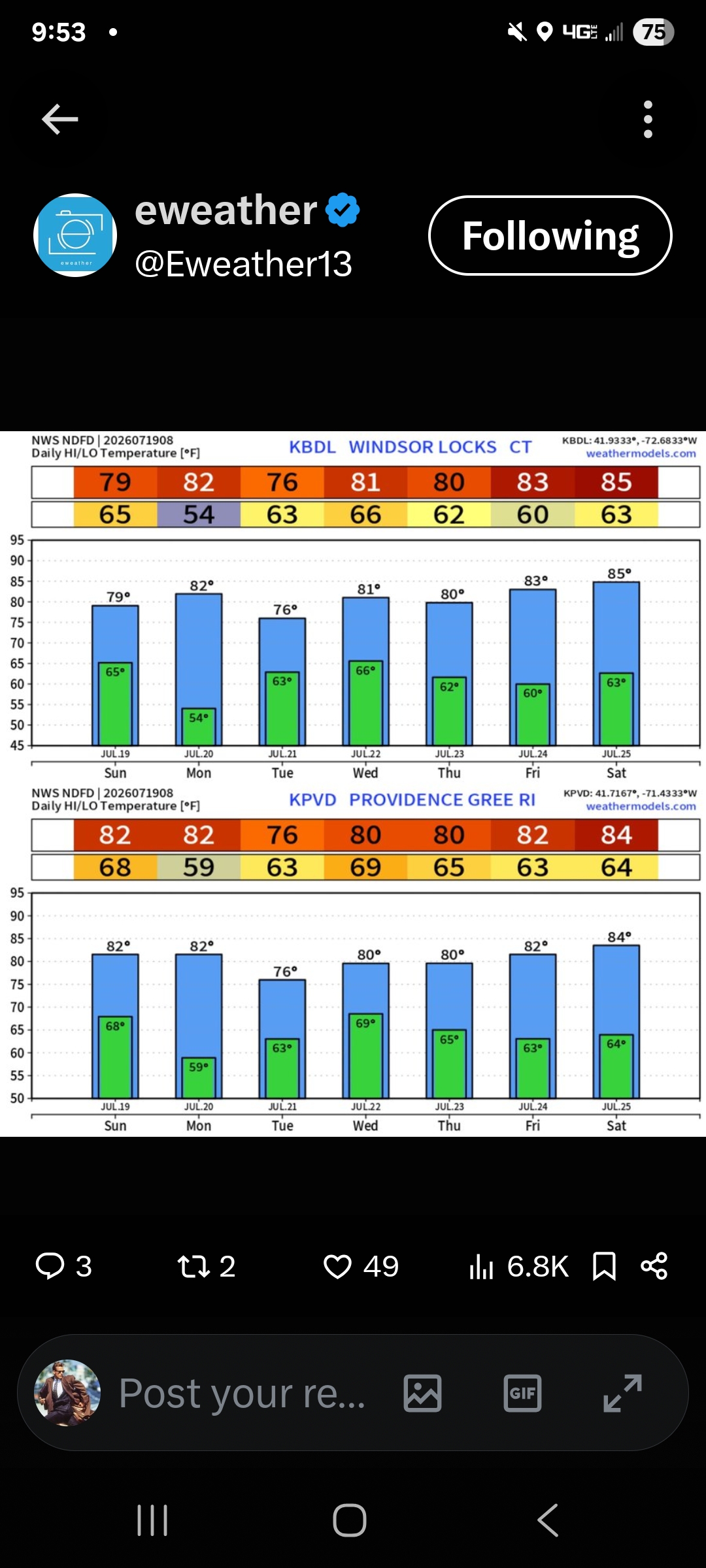
Looks like warm temps the next couple days around 90. We'll see. Point cast is not really that reliable. It was to be 85 yesterday, and only made it to the upper 70's. Smoke has been light.
-
July 19 1987: The town of Floodwood lives up to its name with nearly 6 inches of rain in two days. For Sunday, July 19, 2026 1886 - A hurricane from the Gulf of Mexico crossed Florida causing great damage from Cedar Keys to Jacksonville. (David Ludlum) 1960 - Cow Creek and Greenland Ranch in Death Valley, CA, reported morning lows of 102 degrees. The afternoon high at Greenland Ranch was 124 degrees, and the high at Cow Creek that afternoon was 126 degrees. The coolest low for the entire month for both locations was 82 degrees. (The Weather Channel) 1974 - A severe thunderstorm with winds to 80 mph and up to two inches of rain washed out four to five foot deep sections of roadway in Lake Havasu City, AZ. Three persons in a station wagon died as it was carried 3000 feet down a wash by a ten foot wall of water. (The Weather Channel) 1977 - Thunderstorms produced torrential rains over parts of southwestern Pennsylvania. Some places receive more than twelve inches in a seven hour period. The heavy rains cause flash flooding along streams resulting in widespread severe damage. The cloudburst floods Johnstown with up to ten feet of water resulting in 76 deaths, countless injuries, and 424 million dollars damage. (David Ludlum) (The Weather Channel) 1987 - Fifteen cities in the western and the southeastern U.S. reported record low temperatures for the date, including Winnemucca, NV, with a reading of 33 degrees. Flagstaff AZ reported a record low of 34 degrees. Afternoon and evening thunderstorms produced severe weather in New York State and New Jersey. High winds and hail two inches in diameter injured two persons and caused considerable damage to crops in the Pine Island area of central New York State. (The National Weather Summary) (Storm Data) 1988 - Thunderstorms in Nebraska produced more than five inches of rain at Red Cloud, including two inches in fifteen minutes. Torrid temperatures continued over California, with record highs of 115 degrees at Red Bluff and 116 degrees at Redding. (The National Weather Summary) (Storm Data) 1989 - Early morning thunderstorms in the Lower Mississippi Valley produced 5.50 inches of rain south of Alexander, AR, in just ninety minutes, and flash flooding which resulted claimed the life of one woman. Thunderstorms in Indiana produced 4.95 inches of rain in twelve hours east of Muncie. Eight cities in the southwestern U.S. reported record high temperatures for the date, including Las Vegas, NV, with a reading of 115 degrees, and Phoenix, AZ, with a high of 116 degrees. The low that night at Phoenix of 93 degrees was the warmest of record for that location. (The National Weather Summary) (Storm Data) 2005 - A severe heat wave gripped the region during early to mid-July. Las Vegas, NV tied their all-time record high temperature of 117 degrees, equalling the old record set on July 24, 1942. 2006 - The first of two severe thunderstorms hits the St. Louis area, causing the largest power outage in the city's history with over 570,000 people losing electricity. Observances: 19 Sun National Daiquiri Day 19 Sun Seneca Falls Convention 19 Sun National Ice Cream Day 19 Sun Flight Attendant Safety Professionals' Day 19 Sun International Retainer Day 19 Sun National Football Day 19 Sun National Urban Beekeeping Day 19 Sun National Words with Friends Day
-
 It's been top 5 hottest June 1 through July 15 period with mostly ridging in the east. Only now are troughs being introduced.
 -
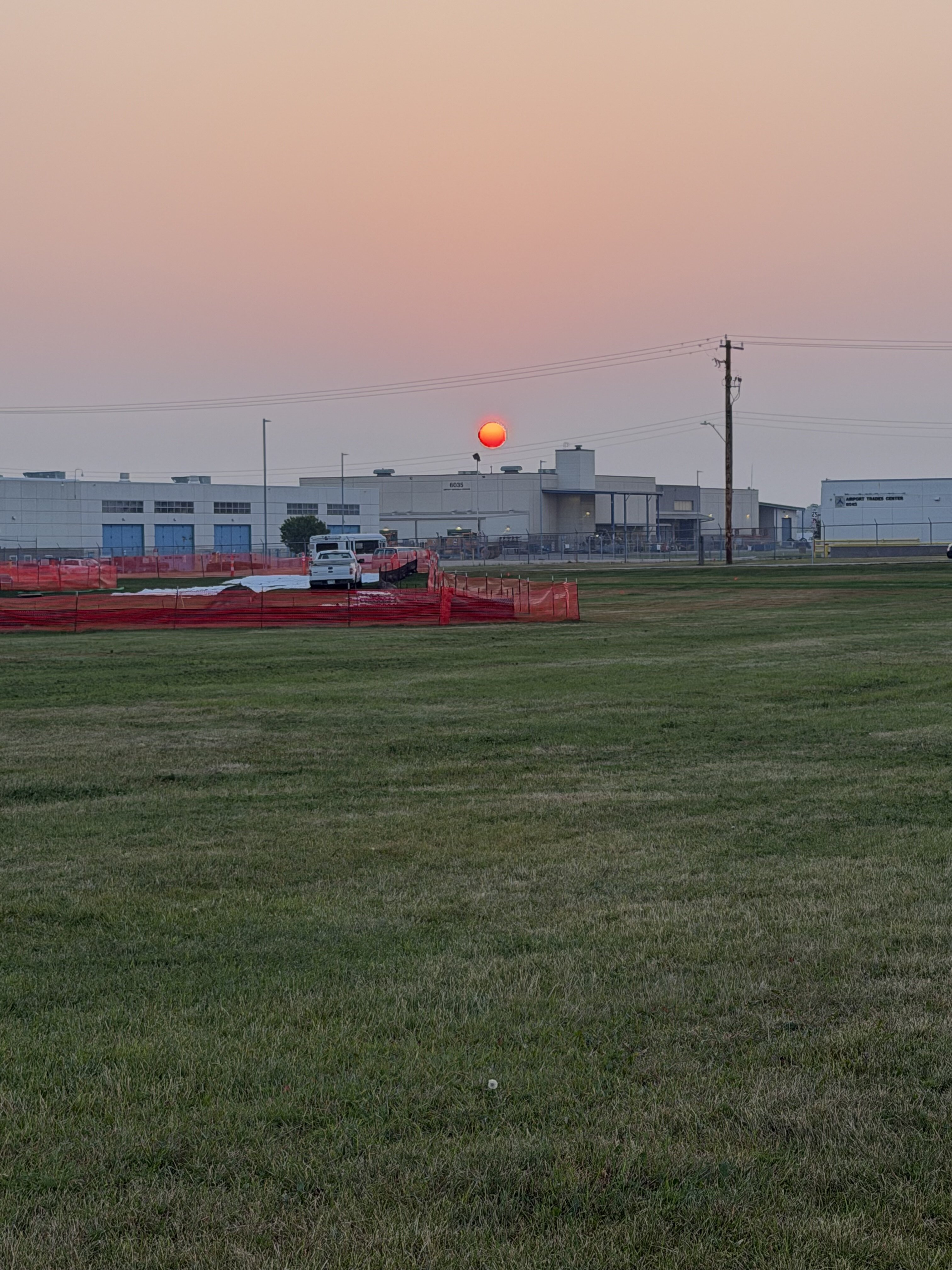
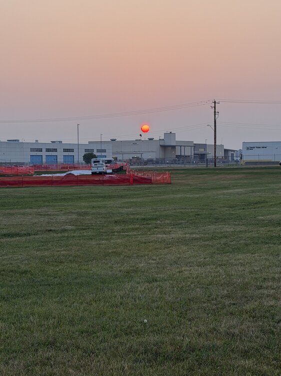
Smoke is back. Sunrise at the airport dog park this morning.
-
 Perfection! Today Sunny, with a high near 74. Northwest wind around 14 mph. Tonight Clear, with a low around 50. Northwest wind around 6 mph becoming calm in the evening. Monday Sunny, with a high near 78. Calm wind becoming west around 6 mph in the afternoon. Monday Night Increasing clouds, with a low around 57. Calm wind. Tuesday A slight chance of showers between 2pm and 5pm, then a chance of showers and thunderstorms after 5pm. Mostly cloudy, with a high near 74. Light south wind increasing to 5 to 10 mph in the morning. Winds could gust as high as 21 mph. Chance of precipitation is 30%. Tuesday Night A chance of showers and thunderstorms, then showers and possibly a thunderstorm after 8pm. Low around 66. Southeast wind 3 to 7 mph. Chance of precipitation is 90%. Wednesday Showers and possibly a thunderstorm. Patchy fog before 9am. High near 76. Southwest wind 5 to 10 mph, with gusts as high as 21 mph. Chance of precipitation is 80%. Wednesday Night Showers likely, mainly before 9pm. Mostly cloudy, with a low around 56. West wind 3 to 8 mph. Chance of precipitation is 60%. Thursday Mostly sunny, with a high near 75. Northwest wind 6 to 8 mph. Thursday Night Mostly clear, with a low around 55. Calm wind. Friday Sunny, with a high near 79. Light west wind. Friday Night Mostly clear, with a low around 57. Calm wind. Saturday Mostly sunny, with a high near 80. Calm wind becoming west around 5 mph in the afternoon.
 -

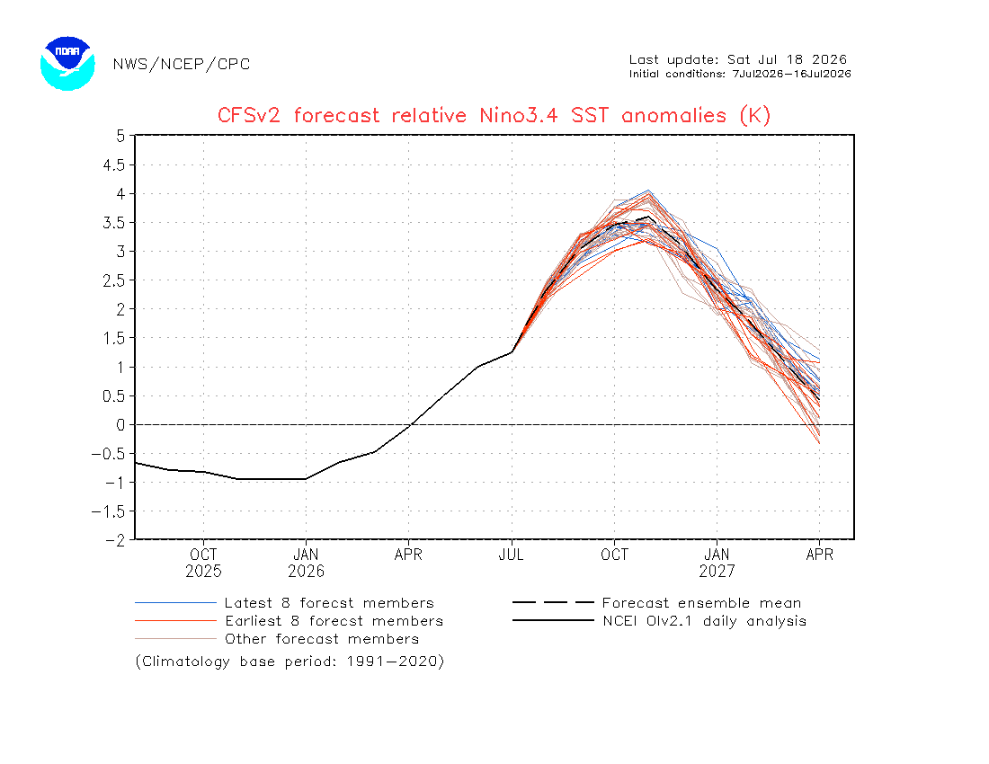
2026-2027 Super El Nino
GaWx replied to Stormchaserchuck1's topic in Weather Forecasting and Discussion
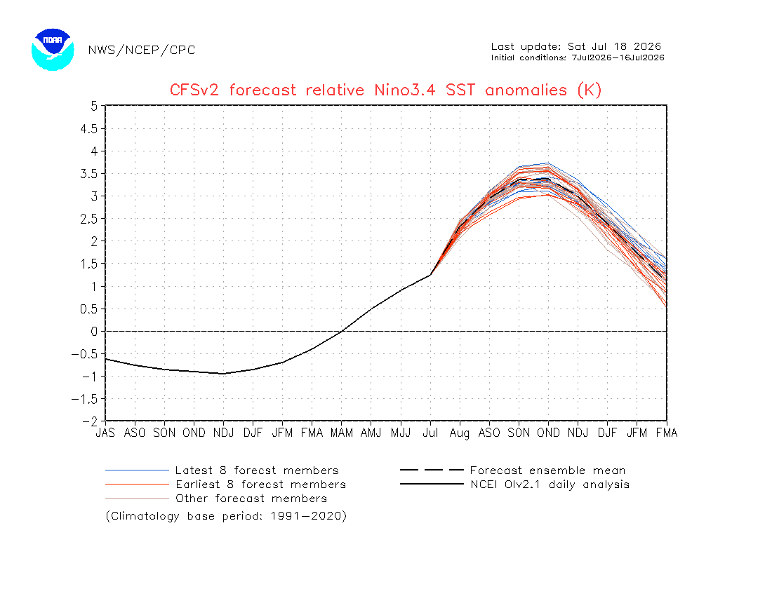
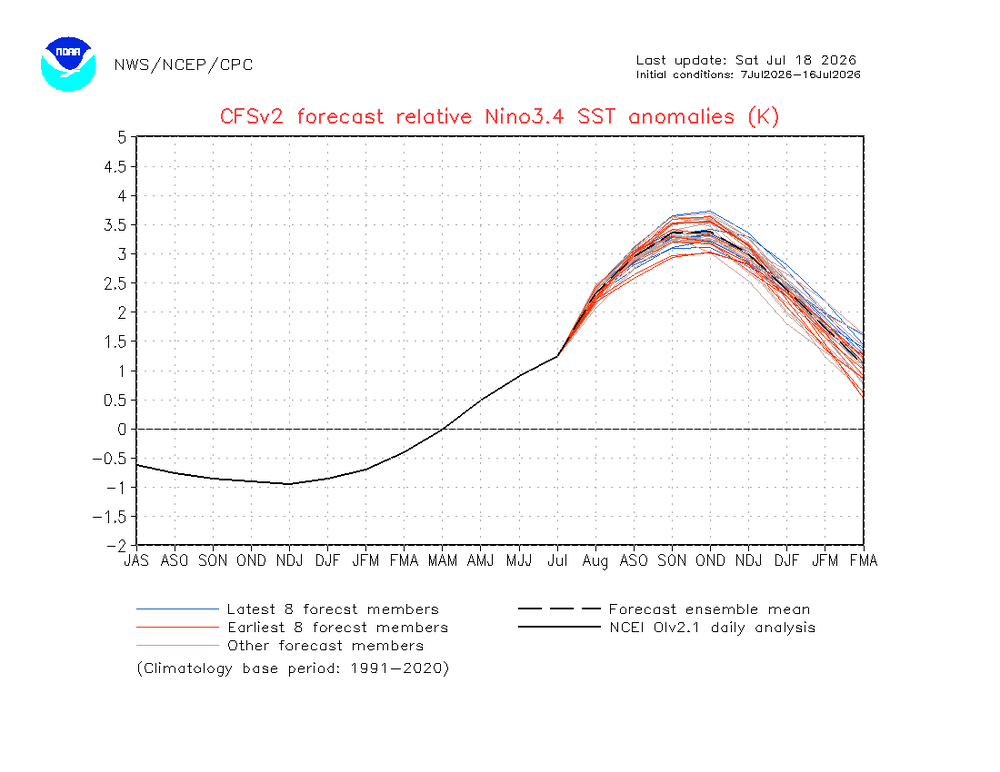
The latest CFSv2 run’s mean is at new highs for peak: Monthly relative 3.4 progged peak ~+3.6 (Nov), which is way above current record (back to 1950) warmest of +2.69 (Jan ‘83) : 3 month relative 3.4 progged peak ~+3.35 (SON and OND), which is way above the record back to 1950 of +2.52 (NDJ 1982-3)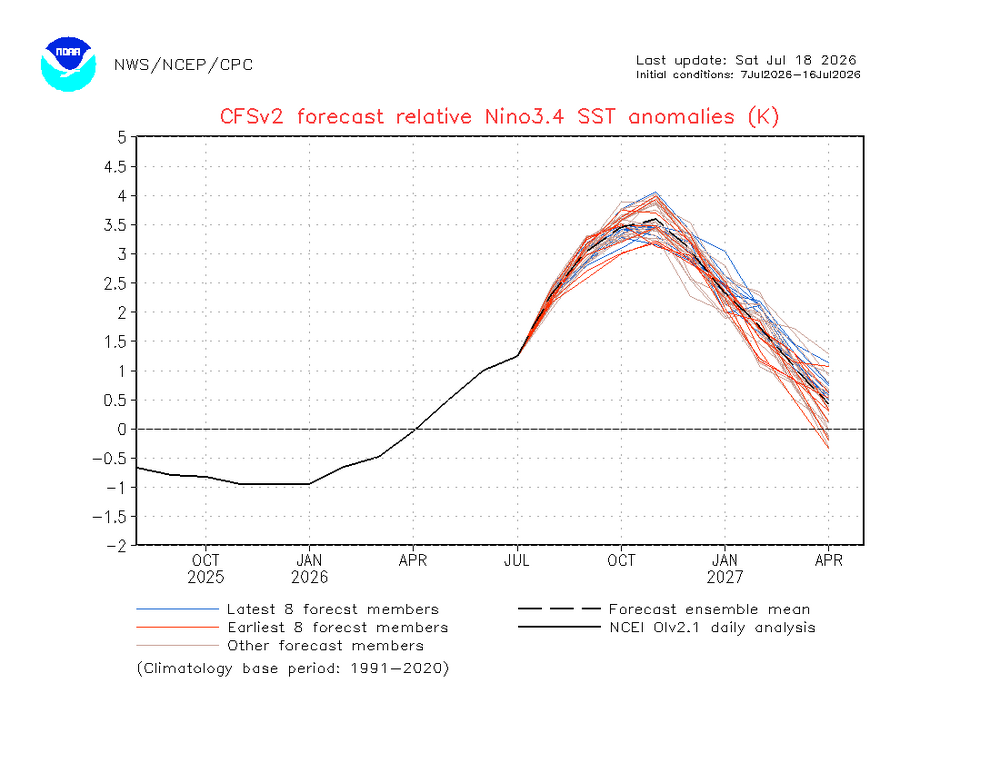
-
Hopefully Canada isn't torched by Pacific puke for most of the winter.
-
 Should be some 40s at the rad sites tomorrow morning.
 -

E PA/NJ/DE Summer 2026 Obs/Discussion
BBasile replied to PhiEaglesfan712's topic in Philadelphia Region
That nice air hasn't quite reached here yet. Currently 77F with a 68 dew. -
Yeah, I should have been more clear - I meant that it "should" be a rainy winter with more southern stream lows. But I will believe in mythical rain when I see it in my desert.
-
 Take those temperatures for the peak of summer.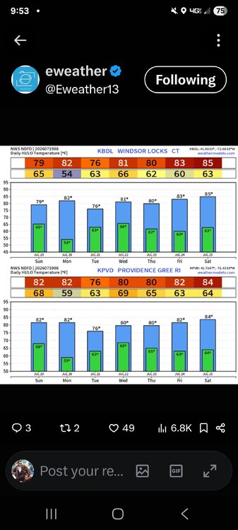
-

Saturday, July 18, 2026 Thunderstorm/Severe Weather Potential
Sey-Mour Snow replied to weatherwiz's topic in New England
Ya there was a long swath of 3-6” in southern CT. -
Back broken?
-

E PA/NJ/DE Summer 2026 Obs/Discussion
LVblizzard replied to PhiEaglesfan712's topic in Philadelphia Region
That cold front feels nice. Windows are open to let in the less humid and non smoky air. Tuesday’s threat looks interesting…would be nice to make up for yesterday’s whiff around here. - Today
-
Picked up 0.03” from a brief but heavy shower this morning and yes, you can slice the air with a knife today. It is that thick
-
 First shot across the bow
 -

2026 Mid-Atlantic Severe Storm General Discussion
Eskimo Joe replied to Kmlwx's topic in Mid Atlantic
What would have been needed for more robust, widespread severe given that profile? -
NHC will initiate advisories on Potential Tropical Cyclone Two (formerly AL91) located over the Gulf of America, at 1000 AM CDT (1500 UTC) Please pin this @buckeyefan1or other mod. TIA