All Activity
- Past hour
-
I'll admit you lost me as you've given us quite a bit to digest there. Gonna need a minute.
-
0.75” in Naperville. Was thinking 0.5” but the tick north on 06z convinced me otherwise. I anticipate a healthy wood virga.
-
Too many people speaking in absolutes too many days out...5 days out ANYTHING is on the table
-
CAPE storm attempt #2? I'm here for you buddy lol. LFG!
-
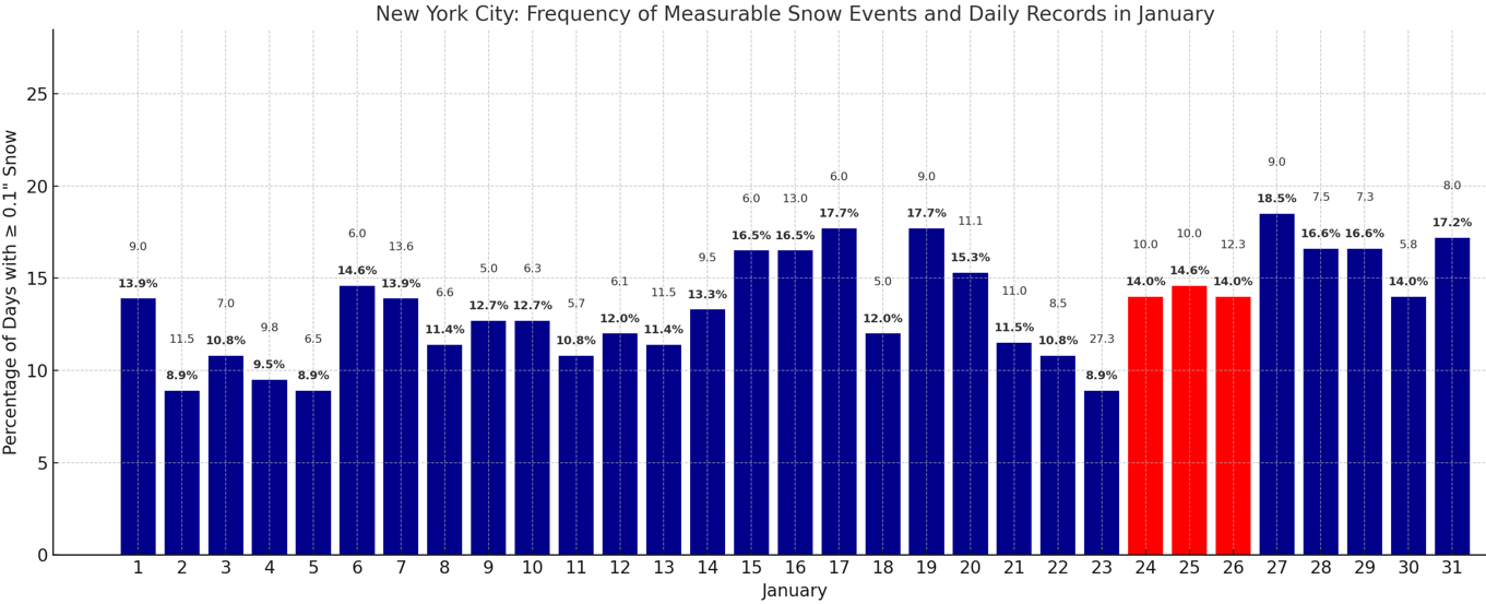
 For reference, the frequency of measurable snow events and the highest daily snowfall. The January 24-26 period is highlighted in red to reflect the coming storm.
-
Spot on GMan! The excitement that builds up days before the expected event is so much fun to discuss. Then we all get hit with that sour bug 3 days before each event. What happened overnight seems pretty typical for 76-84 hours out in the SE. Let's stay calm and see what transpires through tonight. GSP NWS are the best in the business. We are fortunate to have them. And they are responsible for some of the most difficult forecasting in the country. Since they are forecasting from the highest elevations to the Laurens/Greenwood area.
-
Been a good winter, why not!
-

January 25/26 Jimbo Back Surgery Storm
Blacksburg Coach replied to Jimbo!'s topic in Southeastern States
Hey guys, First post on these boards. Looks like those of us from High Point up to Roanoke are on Ice Storm watch as of now. The good news is the Euro soundings look like a lot of sleet before switching to freezing rain at the end. -
This is what model watching is all about folks. We can't expect clean model runs from now until Saturday. In any event, remember this - no one really cares if you switch to sleet if you're staring at a foot of snow. These robust systems tend to do that anyway given their dynamic nature. We can start to panic a bit if the LOW ends up in PA.
-
we do often see models strengthen the hP in the short term. But it's a losing battle if we have a triple phase I fear. The balancing act we need is incredibly thin. We need a strong enough HP and a weak enough Baja interaction to keep things flat and suppressed. But not too flat and also not too strong. Cliomo and history though would tell me to expect a strengthening of the HP and CAD in the short term but the question remains does that really matter if we can't avoid the phase of doom out west? The UK and EURO for sure stopped the trend at 06z but we need a reversal from them starting asap
-
Fuck that. This storm is like getting 2/7 off suit and we flopping deuces and luckies. chips all in before the river.
-
Good morning. Kept my forecast for DC at 4-8+ for now. Probably gonna revise up to 6-10 if the 12z suite doesn’t move much.
-

Richmond Metro/Hampton Roads Area Discussion
eaglesin2011 replied to RIC Airport's topic in Mid Atlantic
Let’s hope that trend continues.. I’m going out to get a generator today (if they aren’t already gone) just in case… Unfortunately where I am the power lines are not buried underground so good chance the power goes out even if it’s just a big snow -

Richmond Metro/Hampton Roads Area Discussion
nw baltimore wx replied to RIC Airport's topic in Mid Atlantic
It sounds like they should, but it also sounds like the northern stream data may not be as well sampled until the arctic high gets over the conus later tomorrow. I could be entirely wrong about that, but reading that WPC statement tells me that it's too early to throw in the towel. -
I would expect some sort of warmer correction and a pullback between lobes of cold air injections. Timing that out is tricky, but might be that late 2nd into third week of the forecast. That's always tough to pick out at this range.
-
#22
-
I'm gutted this morning, too, like the rest of you. It makes me wonder why I even bother with this hobby. I have repeatedly told people it cannot snow anymore in Hickory, and I've been right for the past five years. I actually gave a bit of a positive forecast to several friends/family over the past two days, indicating that this time it finally looked likely we would get some snow. I should never have changed my message, it appears. It's amazing how invested I allow myself to get in this. I do like winter weather, all types, so a mega sleet storm would be something pretty cool to see, but being buried in an inch-plus coating of ice from freezing rain doesn't sound nearly as fun. We will see...
-
2nd day in a row it barely got cold wtf! I got down to 14 in November with no snow cover and I can only get to 18 last night?! Only 20 day before that......
-

January 2026 regional war/obs/disco thread
The 4 Seasons replied to Baroclinic Zone's topic in New England
12Z runs -
They should raise the flood gates in preparation Don't need to put them up if you never take them down. 28.6/14 and full sun Where's the obs thread?
-
Like others are saying, if we can lock in an incredible front-end thump of 10-15” region-wide with 2”/hr rates, I don’t really care if it mixes after the fact.
-

Winter 2025-26 Short Range Discussion
SchaumburgStormer replied to SchaumburgStormer's topic in Lakes/Ohio Valley
Maybe a dab here -

January 2026 regional war/obs/disco thread
ineedsnow replied to Baroclinic Zone's topic in New England
Sunday A chance of snow after 8am. Mostly cloudy, with a high near 13. North wind 3 to 6 mph. Chance of precipitation is 40%. Sunday Night A chance of snow. Mostly cloudy, with a low around 4. North wind 3 to 5 mph. Chance of precipitation is 50%. Monday A chance of snow. Partly sunny, with a high near 18. North wind 5 to 8 mph. Chance of precipitation is 40% -
Low of 1 @ 800 feet in Sparta. It could've ticked lower after I left for work. I had -4 on the car driving out past Newton through Hampton. The digital welcome sign for our campus read -5 at 7:15 am. Also, low of -12 out in Walpack. Impressive cold.
-
Yesterday someone said that it could end up coming too far north and he was mocked mercilessly. This whole "the block is too strong" or "there's no way it can cut with that arctic high" is stupid, because when the models trend in an unfavorable direction the rest of it obviously also changed. Weather is always transient, and never assume anything is impossible. I can think of a million examples of storms that started oht with suppression being the only risk, only to end up raining to Albany.