All Activity
- Past hour
-
I know there’s a few forecasts out there calling for a hyperactive/high ACE Atlantic season (namely JB…surprise, surprise), but this should lend some big pause:
-
Nothing heavy here 0.22” overnight
-
Third consecutive 1”+ CoCoRaHS report. That’s a rarity. Just shy of 4” total. Will be interesting to see the ground truth totals from Burke to Ft Belvior.
-
Incredibly cool for mid June.
-
Wxrisk.com updated their profile picture. entsodopSr1fil9mf0337l46l03cm00l2hai8ahh70i7433u207455185th4 · LOW MID 90s a good bet JUNE 22-28 east of the mountains
-
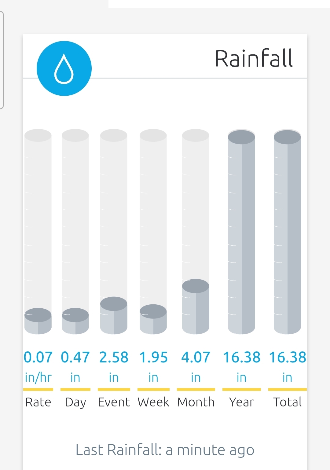
After getting skunked on Friday I'm pretty surprised at these totals. Still lightly raining. 2.58" Saturday to this morning

- Today
-
60 degrees this morning. Picked up .05” rain overnight. My fishing league starts this week and looks like it is going to get canceled due to high water. River been running high all season, one of the worst springs I can remember for fishing.
-
-
Another 1” on top of 0.9” for a total of 1.9” this weekend. 2.5” MTD
-
 W3era changed their profile photo
 -
W3era joined the community
-
The models look hot as hell in the long range. Hopefully they're all wrong.
-
And here it has been dry all weekend other than a few minutes of very light drizzle. Grey and dreary in the 60s, so not summery but not bad. I even had to water some of the garden.
-
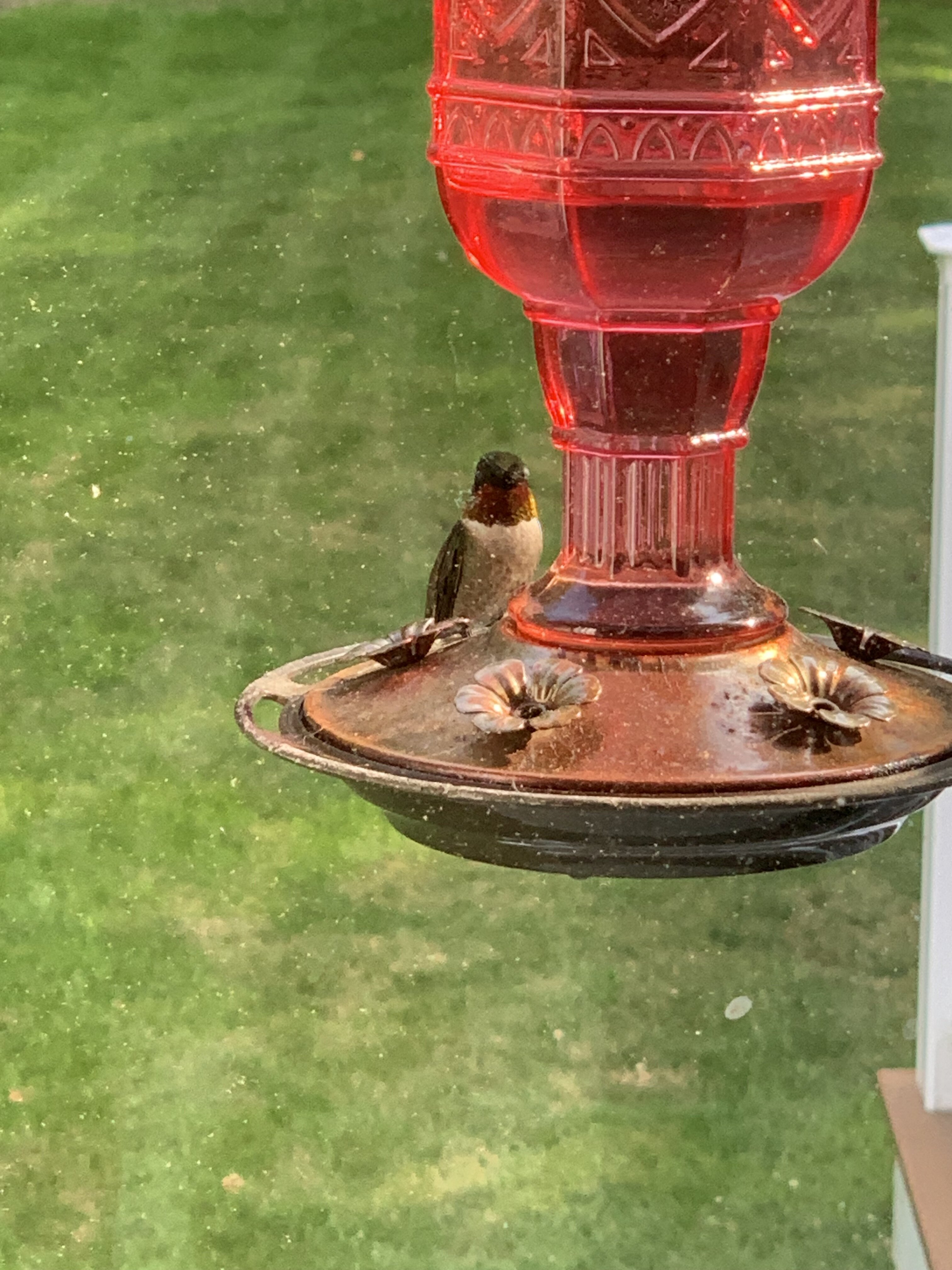
No wonder the hummers have been going crazy lately. They must have some sense of what’s coming. It’s weird as for the last few weeks or so, the feeders have been kind of quiet after the early surge in May and now they’re back with a vengeance! I think we should take the hint.

-
 Meatyorologist joined the community
 -
 centralvawx joined the community
 -
I can remember days in July & August when temperatures stayed in the low 60s and it rained all day. It's not common, but it happens once in a while. WX/PT
-

June 2025 discussion-obs: Summerlike
LongBeachSurfFreak replied to wdrag's topic in New York City Metro
60s would have been nice, right on the ocean it struggled at 59 for most of the day. The cloud deck was so thick there was almost no noticeable warming even in the afternoon. -
39° and rain Friday afternoon. What a way to start the weekend.
-
It seems to come a tropical downpour here around every 2 or 3 hours, all day and all night and that forecast looks to hold through about Thursday. We may get hot after that, but it's so wet, it's tough to get too hot here. It will take some soil drying to pull it off.
-
Could definitely use some in fallston area - mostly a whiff over the weekend so far - so something overnight would be welcome.
-
Lots of places 2” plus. Got zero here crazy. We could use a little
-
I will probably be fact checked, but I really can't remember a 3 day stretch (yesterday today and tomorrow) so far into June that stayed in the 60s.
-
Up to 1.85 in today and it is still raining. EDIT: Looks like it has finally stopped and today's total was 1.91 in.
-
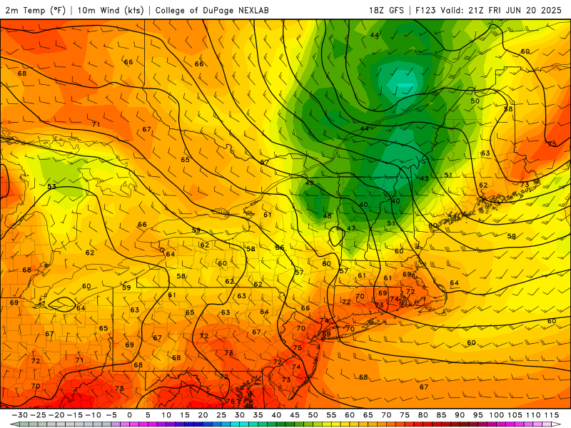
Big heat and humidity hit this weekend and look to last without a real end in sight. That short wave Thursday looks legit. Major severe potential for nearly the entire state, depending on timing.
-
We haven't done squall lines well at all in the Mid-Atlantic in recent years, but this setup certainly favors very organized intense convection. Pop-up stuff occurs with weak forcing, and the cold front arriving during peak heating (and it should plenty hot with high dew points) with a modestly strong upper level trough will provide strong forcing.
- 1,034 replies
-
- 2
-

-
- severe
- thunderstorms
- (and 2 more)
-
Could be, or it could just be low-level speed convergence which is kind of hinted at on a few HRRR 850 mb images. Regardless, us Howard County folks look to be left out of the show again......
-
Dry weekend here so far. Today was nice for planting, I'm another who did that. Maybe some hope on radar.
-
Parr's Ridge is a force. It could be dry on my commute to Columbia and then a sprinklefest as I pass Mt. Airy.