All Activity
- Past hour
-
Lot of crispy tcu going up. Can see your anvil bombs on the N-NW horizon. Fun day
-

Central PA Summer 2026 Discussion/Obs Thread
Superstorm replied to Voyager's topic in Upstate New York/Pennsylvania
Gorgeous weather. Bottle this up! . -
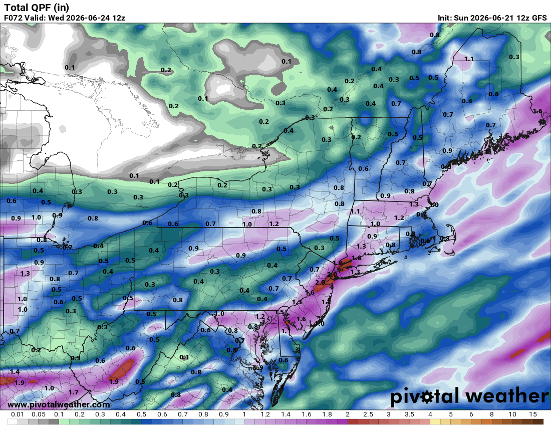
Certainly would be nice if GFS is right about heavy rain across our area, but who knows. 12z HRRR has heavy rain going over our area, but obviously the day before it's very difficult for the models to predict which areas will get 1 to 2 inches and which areas only a quarter inch. Hopefully we'll get lucky with the heavy downpours. I'm desperate for heavy rain.
-

2026-2027 Super El Nino
LakePaste25 replied to Stormchaserchuck1's topic in Weather Forecasting and Discussion
Not that unusual in super Nino events. I wouldn’t expect 24/7 +AAM and it’ll probably bounce back quickly. -

2026 Spring/Summer Mountain Thread
Maggie Valley Steve replied to Buckethead's topic in Southeastern States
Happy Summer Solstice! It's all downhill from here until Fall! -
FWIW - the 12z CSU MLP maps have reduced quite a bit.
-
It's been great so far. But me thinks this rubber band is about to snap lol.
-
2026-2027 Super El Nino
LakePaste25 replied to Stormchaserchuck1's topic in Weather Forecasting and Discussion
I know @bluewave brings this up a lot, but I will forever be fascinated by the clean phase 8 pass through in January 2022. With all of the competing Nina forcing going on, I don’t know how we pulled that off especially during an actual Nina. -
I hope that stuff stays east of me. Got the grill going and don’t want to stand out in the rain
-
2026-2027 Super El Nino
LakePaste25 replied to Stormchaserchuck1's topic in Weather Forecasting and Discussion
I consider 2021-2022 to be an east-based La Niña.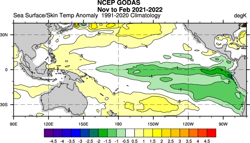
-

Central PA Summer 2026 Discussion/Obs Thread
Itstrainingtime replied to Voyager's topic in Upstate New York/Pennsylvania
What makes you say that? WPC precip map is weighted heavily to our NE with the heaviest rainfall. -

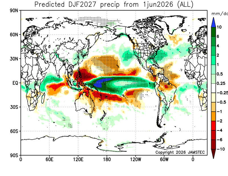
2026-2027 Super El Nino
mitchnick replied to Stormchaserchuck1's topic in Weather Forecasting and Discussion
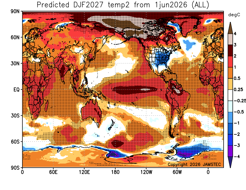
The Jamstec. My new favorite seasonal model...so far. https://www.jamstec.go.jp/aplinfo/sintexf/e/seasonal/outlook.html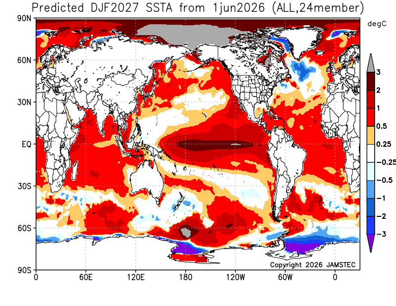
- Today
-

Central PA Summer 2026 Discussion/Obs Thread
mahantango#1 replied to Voyager's topic in Upstate New York/Pennsylvania
I'm glad I have my irrigation pump set up to pump water out of the creek for my garden. I watered Friday and yesterday morning. -
Just had a really close CG. Just getting grazed by a developing cell.
-
Beautiful Father’s Day. Enjoy all
-
Yeah I would expect the latter in the warm season but those can also produce big rains.
-
It's interesting how that thing's changed over the week running up to it ... It was originally sort of weird quick coastal ( that looked dubious, admittedly), replete with a burst of NE flow and drilling rains ... Probably 60 F tops. Now, it's more like it's just a humid disjointed morass with less structure overall.
-
Yep-skunk zone. T-storms area to the south and stratiform heavy rain along I-90. We need it, hope I’m wrong. But this is a summer SWFE that always tries to nudge north. Maybe the T-storms zone can nudge N too.
-
On target for the worst Fathers Day I remember.
-
I've heard (usually from @high risk ) that the HRRR tends to overmix out low level moisture - could that be a factor here?
- 817 replies
-
- 1
-

-
- severe
- thunderstorms
- (and 7 more)
-
HRRR and RRFS have meaty storms and in two distinct waves. However, CAPE is rather low for this time of year for a svr event. Hodographs look better on the NAM/HRRR but not so much on the RRFS. 0-3 km CAPE is lacking on the HRRR and RRFS, so I have to wonder about tor potential. It is fairly strong s/w for June passing just to our N and overall wind fields are good, so perhaps the dynamical part will make up for the rather low CAPE and that's why the HRRR and RRFS show meaty storms. PWATs ramp up nicely during the day. K-indices fcst get to upper 30s so likely big rain producers.
- 817 replies
-
- 2
-
-
- severe
- thunderstorms
- (and 7 more)
-
Another cloudy dreary day. I can't believe how stuck in this cloudy wet pattern we have been in here. About a month so far. Depressing.
-
I'm more "in" on this one than the prior events. It could still fizzle - and I certainly don't think it's going to be an "outbreak" - but storm coverage has higher confidence it seems - and the shear does raise some eyebrows! Also I'll be in the office - which seems to guarantee good storms (my office is in the core of the building with no windows - so I essentially miss anything that happens during cool events).
-

2026-2027 Super El Nino
PhiEaglesfan712 replied to Stormchaserchuck1's topic in Weather Forecasting and Discussion
About 2 years ago, I did the composites on the moderate and strong la ninas. 1975-76 was the closest to being east based of the strong la ninas. 1949-50 is probably the best example of an east based la nina, with 1970-71 and 1984-85 possibly being east based.