All Activity
- Past hour
-
I know it won’t happen this way (probably), but I’m gonna get grumpy if every front in the next 10 days passes at like 5am like today’s guidance wants to do
-

2026-2027 Super El Nino
GaWx replied to Stormchaserchuck1's topic in Weather Forecasting and Discussion
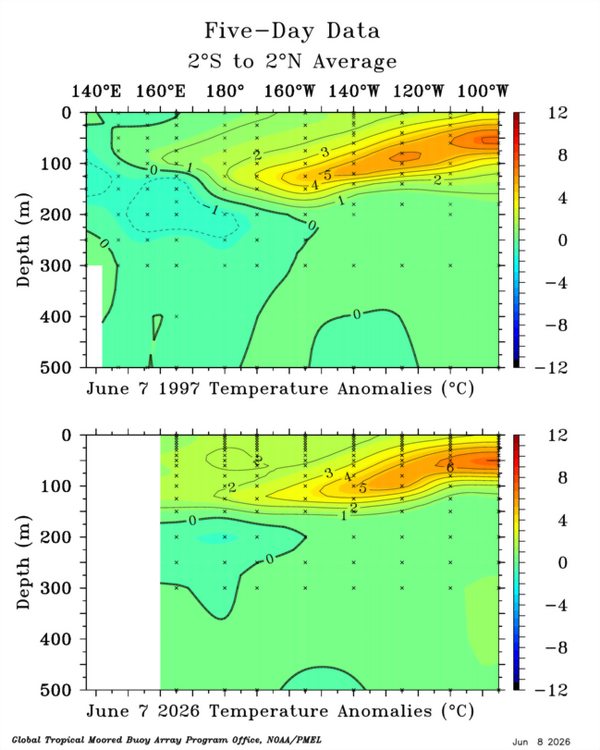
Thanks. Some of us have already been discussing ‘26-7 vs ‘97-8. On Saturday I posted that per the Euro progs, ‘26-7 is looking to evolve into a much less E based Nino than ‘97-8, which became the most E based Nino on record (back to 1951-2). When I refer to E based, I’m referring to the differences between 1+2 and 3 vs 3.4 and 4. This is what I posted: More on 97. Here were the monthlies: 1+2 3 4 3.4 1997 6 26.12 3.00 28.13 1.51 29.23 0.26 28.82 1.09 1997 7 25.59 3.63 27.90 2.09 29.37 0.47 28.86 1.56 1997 8 24.96 3.96 27.71 2.59 29.29 0.50 28.75 1.89 1997 9 24.69 3.96 27.74 2.84 29.44 0.68 28.85 2.13 1997 10 24.69 3.67 28.06 3.08 29.34 0.58 29.08 2.36 1997 11 26.12 4.47 28.37 3.27 29.39 0.69 29.12 2.41 1997 12 27.06 4.25 28.53 3.30 29.11 0.57 28.89 2.29 1998 1 28.12 3.55 28.74 3.08 28.95 0.64 28.93 2.38 1998 2 28.74 2.64 28.90 2.49 28.79 0.59 28.78 2.03 1+2 (peak 4.47) and 3 (peak 3.3) were way, way stronger than 4, which remained just wk (peak 0.69) and even way stronger than 3.4 (peak 2.41)! The forecast for ‘26 is much stronger in 3.4/4 and stronger in 3, but not as strong in 1+2: Per latest Euro, here are peak non-rel. monthlies: 1+2: 3.9 3: 3.9 3.4: 3.7 4: 2.4 That’s only a contrast of 1.5 from E to W compared to 3.8 in ‘97! And contrast from 1+2 to 3.4 is a mere 0.2 vs 2.1 in ‘97!! So, the prog is for ‘26 to be E based but way more balanced and thus not nearly as E based as the extremely E based ‘97. -

Central PA Summer 2026 Discussion/Obs Thread
mahantango#1 replied to Voyager's topic in Upstate New York/Pennsylvania
76 was the high here today. -

Junorch obs and discussion 2026
Damage In Tolland replied to Damage In Tolland's topic in New England
You can’t just look at mapped out charts for temps. Look big picture, Climo , water in ground , source region , trough axis etc . If you look at everything the pattern next week looks like 78-86 for highs . Probably a day or two like today then warming -

2026-2027 Super El Nino
Typhoon Tip replied to Stormchaserchuck1's topic in Weather Forecasting and Discussion
As the humanity bus goes over the cliff… -

Mid-Long Range Discussion 2026
WinstonSalemArlington replied to BooneWX's topic in Southeastern States
-
Too early for that No, it looks to me more like it’s just a regression to what happened all last winter Very sting Ninos more correlate to a sub tropical jet and on this side of the solstice with summer still suing we are nowhere near engineering that sort of hemispheric response until the seasonal gradient steepens next autumn/winter That is … if it really gets strong enough to exceed RONI numbing
-
Got slammed again with .39" in less than an hour earlier. Some hail but nothing bigger than marble size.
-

2026-2027 Super El Nino
donsutherland1 replied to Stormchaserchuck1's topic in Weather Forecasting and Discussion
It will be interesting to see how strong the ongoing and rapidly developing El Niño becomes. Only the 1997-98, 2015-16, and 2023-24 El Niño events saw the 6-week moving average for Region 3.4 reach or exceed +0.9°C in June or July. -
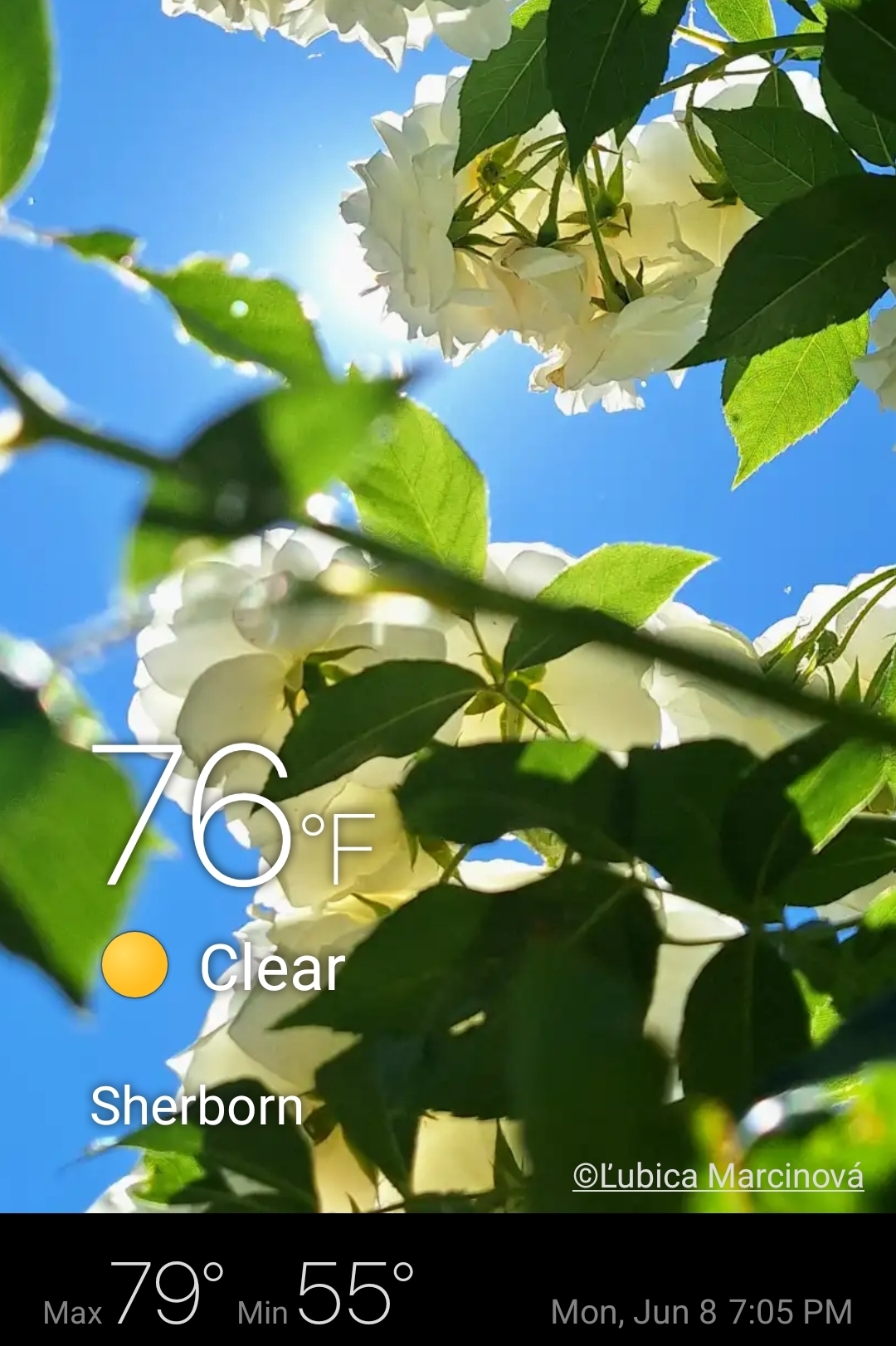
Absolute perfection out there now. 76° / 48° with clear skies.

-

2026-2027 Super El Nino
so_whats_happening replied to Stormchaserchuck1's topic in Weather Forecasting and Discussion
So when can we start to discuss the differences between how these two similiarish ENSO events will evolve?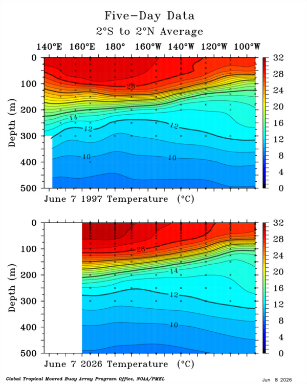
-
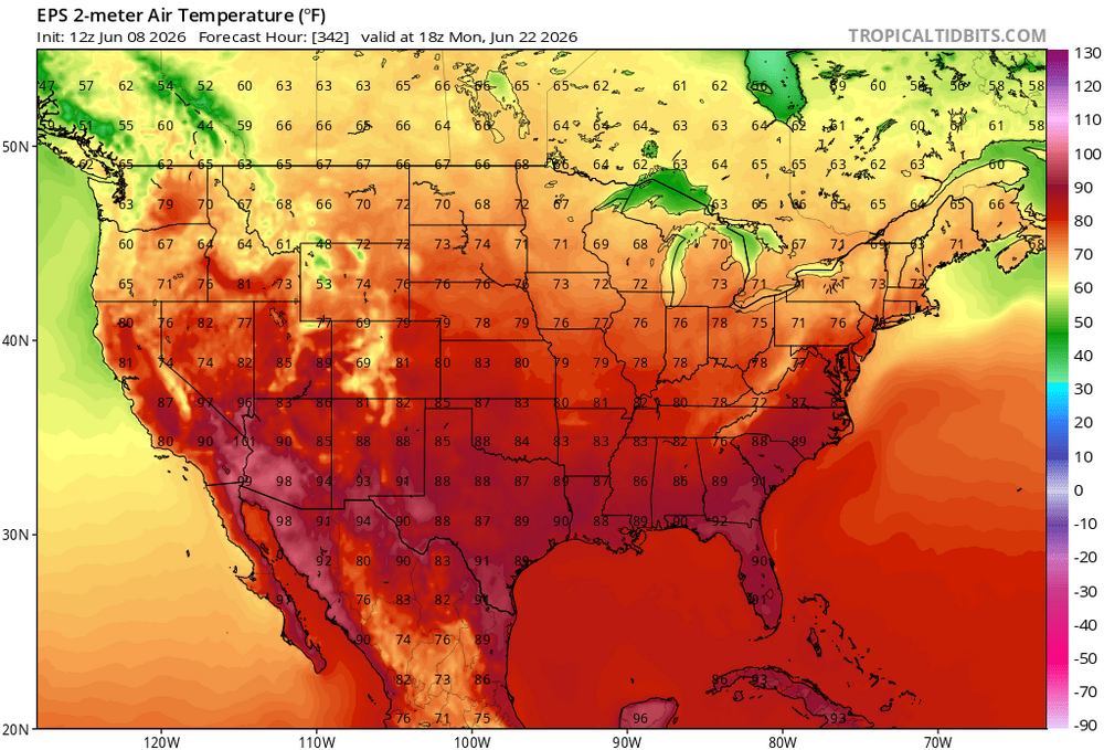
So I should just pencil in my PDS blizzard warning?

-
Yeah its not a hot pattern, we'll see if we sneak in a day or two of post front/wave clouds and cool
-
EPS not much better there sparky
-
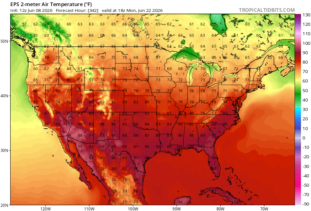
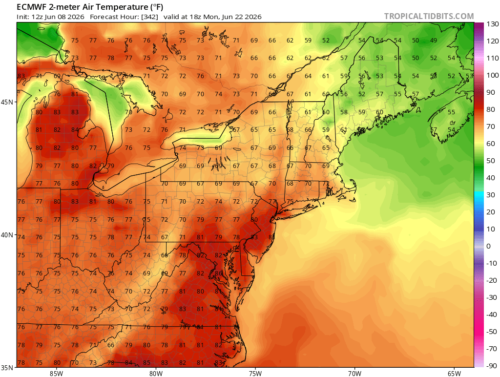
Above normal temperatures will return for the remainder of the week by Wednesday or Thursday. Tomorrow will see highs in the lower 80s. Wednesday should see highs in the lower to perhaps middle 80s. The temperature could approach or reach 90° to end the week. Parts of the region could experience a heatwave during the second half of the week. The ENSO Region 1+2 anomaly was +2.6°C and the Region 3.4 anomaly was +1.3°C for the week centered around June 3. For the past six weeks, the ENSO Region 1+2 anomaly has averaged +1.95°C and the ENSO Region 3.4 anomaly has averaged +0.98°C. The ongoing El Niño will continue to strengthen through the summer. The SOI was -25.52 today. The preliminary Arctic Oscillation (AO) was +0.597 today. Based on sensitivity analysis applied to the latest guidance, there is an implied near 76% probability that New York City will have a warmer than normal June (1991-2020 normal). June will likely finish with a mean temperature near 74.8° (2.8° above normal). That would make June 2026 the fifth warmest June on record. Supplemental Information: The projected mean would be 3.4° above the 1981-2010 normal monthly value.
- Today
-
non-confirmed tornado warning with now hail high into the sky, 60dbz going way up there
-
Junorch obs and discussion 2026
Damage In Tolland replied to Damage In Tolland's topic in New England
Remember the last few time you did this . Posted op runs. And they turned out 20-30 degrees warmer upon verification. When will you learn? -

-
-
At 7am
-
Mid-Long Range Discussion 2026
WinstonSalemArlington replied to BooneWX's topic in Southeastern States
Monster trough next week -
It was puking hail for a long bit for me, clogging gutters. But most of it half inch or smaller. Largest one I found was a hair over an inch, but those didn't last long.
-

2026-2027 Super El Nino
Brewbeer replied to Stormchaserchuck1's topic in Weather Forecasting and Discussion
Those of us with access to resources will probably manage ok and pull through just fine. It’s the ones who don’t that we need to be thinking about. -
Annoyed I will be missing the severe threats in MBY due to a planned trip to Cleveland to visit family tomorrow through Friday.
-
I thought today was supposed to be warmer. It’s an absolutely beautiful day.


.thumb.gif.f92b16c631a1d15d405ed77b33f0710d.gif)